Narrow Results By
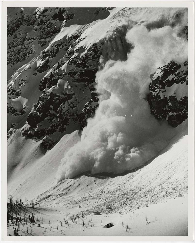
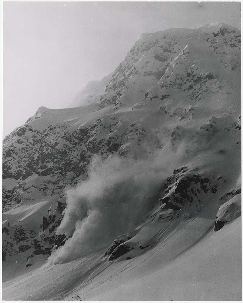
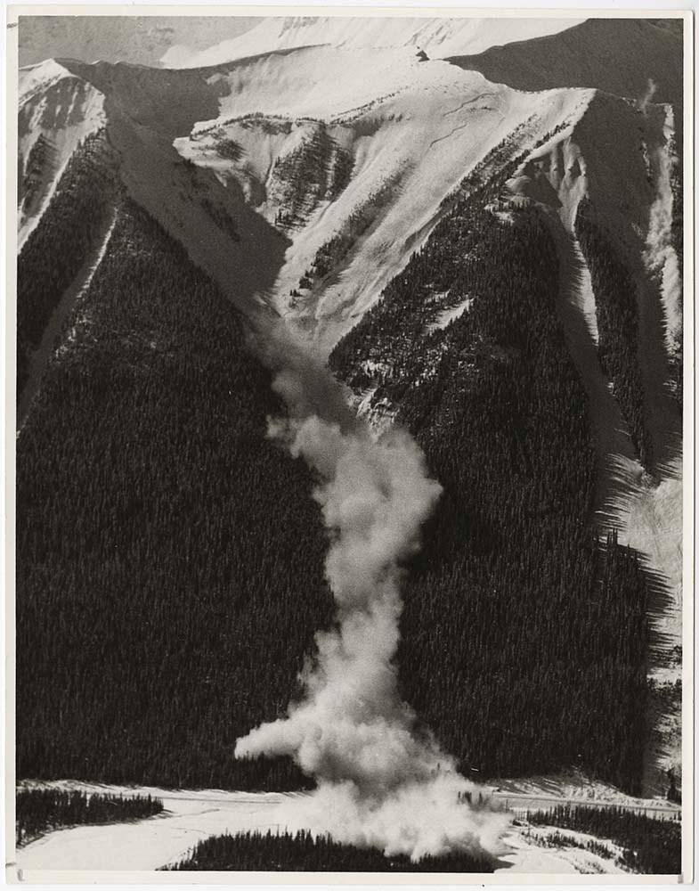
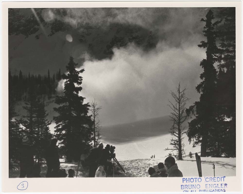
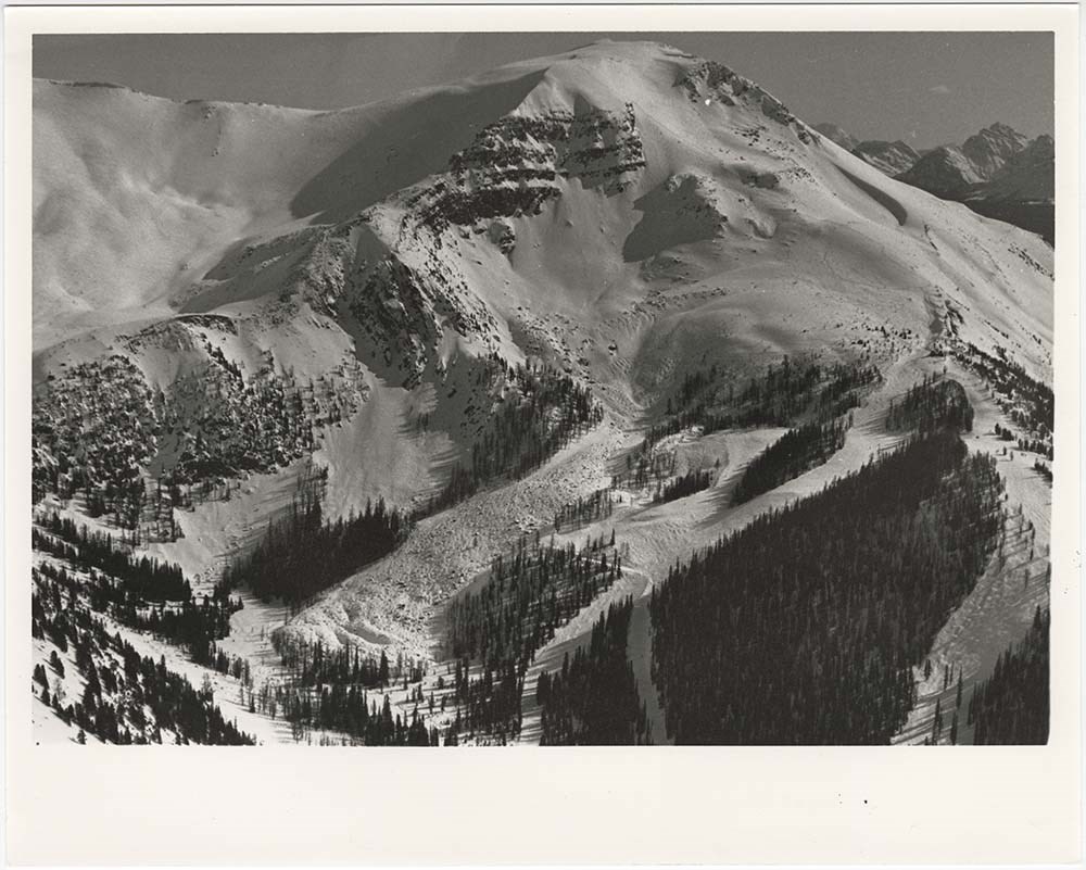
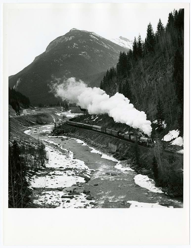
Avalanche -- Banff-Jasper [2/2]
https://archives.whyte.org/en/permalink/descriptions56747
- Part Of
- Bruno Engler fonds
- Scope & Content
- File pertains to 31 b&w prints of aerial photographs of mountains in winter with a road featured at the bottom of the frame - most likely the Banff-Jasper Highway. Also includes close-up shots of various avalanches, including a controlled blast filmed by a group of people and another controlled bla…
- Date Range
- [ca. 1980]
- Reference Code
- V190 / VI / A / vi / b / PA - 29 to PA - 59
- Description Level
- 5 / File
- GMD
- Photograph
5 images
- Part Of
- Bruno Engler fonds
- Description Level
- 5 / File
- Fonds Number
- M323 / S40 / V190
- Series
- VI : Retained file, A : Alphabetical order
- Sous-Fonds
- V190
- Sub-Series
- vi : Avalanches, b : Banff-Jasper
- Accession Number
- 7436
- Reference Code
- V190 / VI / A / vi / b / PA - 29 to PA - 59
- GMD
- Photograph
- Date Range
- [ca. 1980]
- Physical Description
- 31 photographs : b&w ; 20.3 x 25.4 cm or smaller
- History / Biographical
- See fonds level description
- Scope & Content
- File pertains to 31 b&w prints of aerial photographs of mountains in winter with a road featured at the bottom of the frame - most likely the Banff-Jasper Highway. Also includes close-up shots of various avalanches, including a controlled blast filmed by a group of people and another controlled blast via helicopter along the Banff-Windermere Highway.
- Subject Access
- Aerial photography
- Avalanches
- Banff-Jasper Highway
- Banff-Windermere Highway
- Mountains
- Winter
- Geographic Access
- Banff National Park
- Jasper National Park
- Kootenay National Park
- Alberta
- Language
- English
- Creator
- Engler, Bruno
- Title Source
- Original title kept
- Processing Status
- Processed
Images

This material is presented as originally created; it may contain outdated cultural descriptions and
potentially offensive content.
Read more.
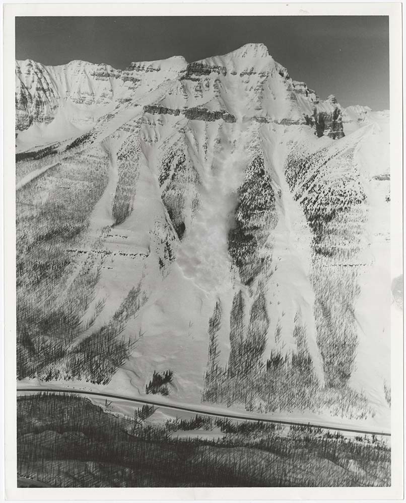
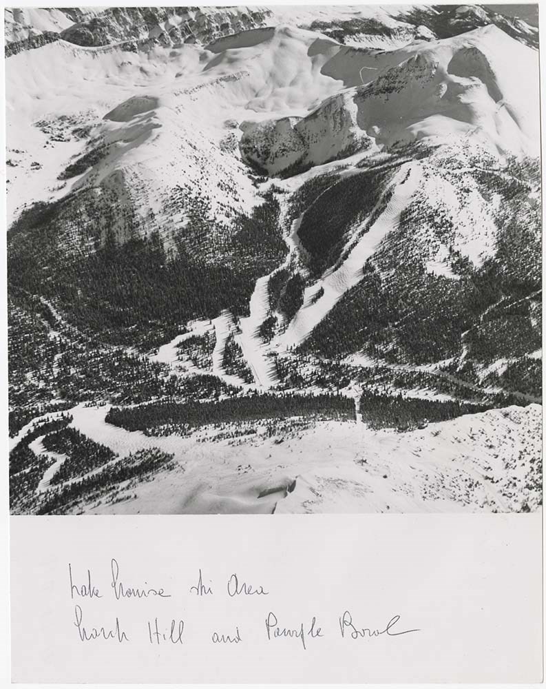
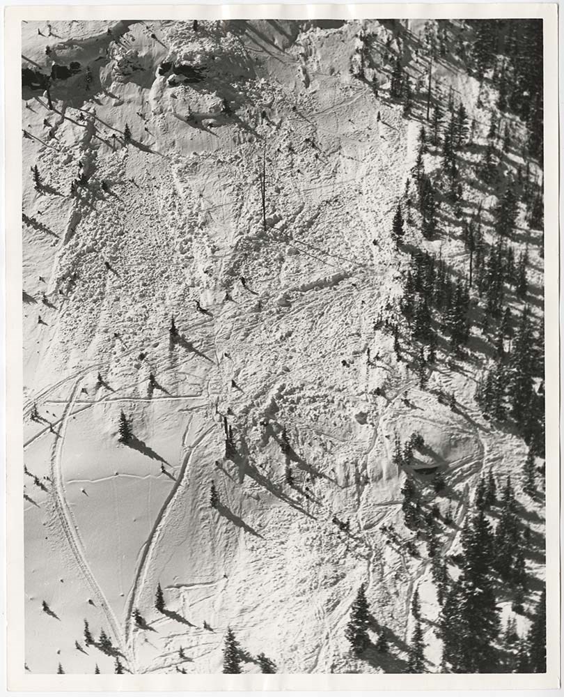
Avalanche Zones
https://archives.whyte.org/en/permalink/descriptions56753
- Part Of
- Bruno Engler fonds
- Scope & Content
- File pertains to 58 b&w prints of various avalanche areas and slides around Banff National Park, mostly focussed along stretches of highways and in and around ski areas, including backcountry ski areas like Assiniboine.
- Date Range
- [ca. 1977-1990]
- Reference Code
- V190 / VI / A / vi / d / PA - 01 to PA - 58
- Description Level
- 5 / File
- GMD
- Photograph
4 images
- Part Of
- Bruno Engler fonds
- Description Level
- 5 / File
- Fonds Number
- M323 / S40 / V190
- Series
- VI : Retained file, A : Alphabetical order
- Sous-Fonds
- V190
- Sub-Series
- vi : Avalanches, d : Zones
- Accession Number
- 7436
- Reference Code
- V190 / VI / A / vi / d / PA - 01 to PA - 58
- GMD
- Photograph
- Date Range
- [ca. 1977-1990]
- Physical Description
- 58 photographs : b&w ; 20.3 x 25.4 cm or smaller
- History / Biographical
- See fonds level description
- Scope & Content
- File pertains to 58 b&w prints of various avalanche areas and slides around Banff National Park, mostly focussed along stretches of highways and in and around ski areas, including backcountry ski areas like Assiniboine.
- Subject Access
- Aerial photography
- Avalanches
- Banff-Jasper Highway
- Backcountry skiing
- Lake Louise Ski Area
- Mountains
- Ski areas
- Sunshine Ski Resort
- Winter
- Geographic Access
- Banff National Park
- Alberta
- Mount Assiniboine
- Mount Assiniboine Provincial Park
- British Columbia
- Language
- English
- Related Material
- V190 / VI / A / vi / d / NA - 01 to NA - 09
- Creator
- Engler, Bruno
- Title Source
- Original title kept
- Processing Status
- Processed
Images
This material is presented as originally created; it may contain outdated cultural descriptions and
potentially offensive content.
Read more.
Azure River 83D/12 B.C.
https://archives.whyte.org/en/permalink/catalogue23459
- Medium
- Library - Maps and blueprints (unannotated; published)
- Map
- Published Date
- 1986
- Publisher
- Surveys and Mapping Branch, Dept. of Energy, Mines and Resources
- Edition
- 3rd ed.
- Call Number
- NTS
- 83D/12
- Edition
- 3rd ed.
- Publisher
- Surveys and Mapping Branch, Dept. of Energy, Mines and Resources
- Published Date
- 1986
- Physical Description
- 1 map : col
- Scale
- Scale: 1:50,000
- Relief: Contour interval 100 feet.
- Subjects
- Azure River
- British Columbia
- Notes
- National Topographic System
- Accession Number
- 19,000
- Call Number
- NTS
- 83D/12
- Collection
- Archives Library
This material is presented as originally created; it may contain outdated cultural descriptions and
potentially offensive content.
Read more.
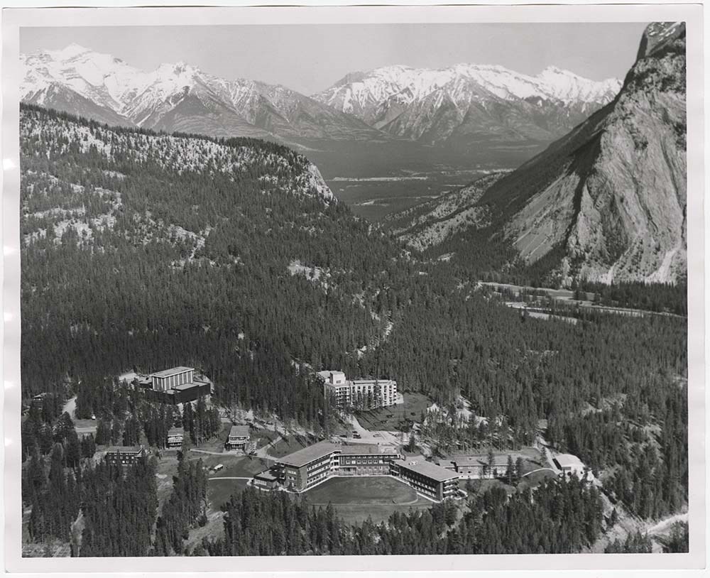
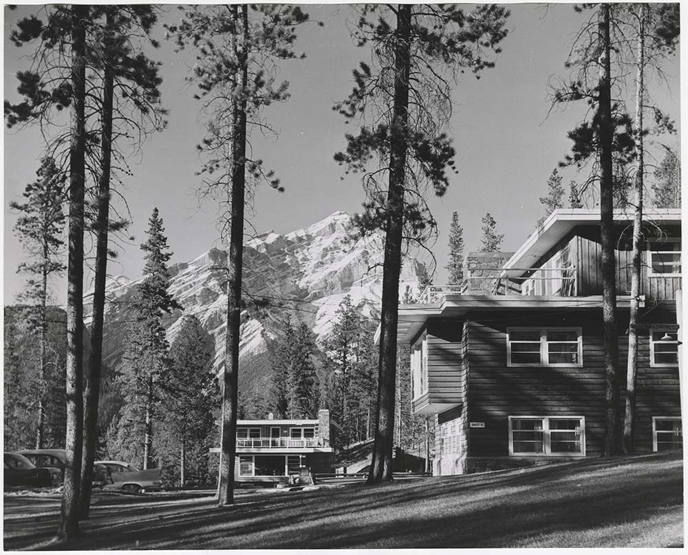
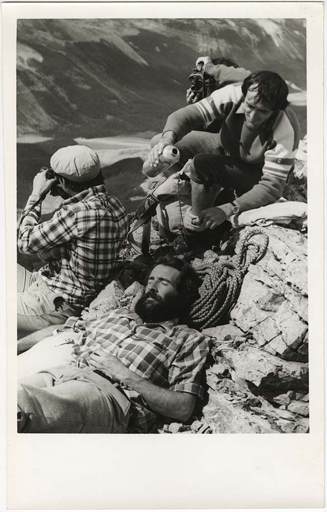
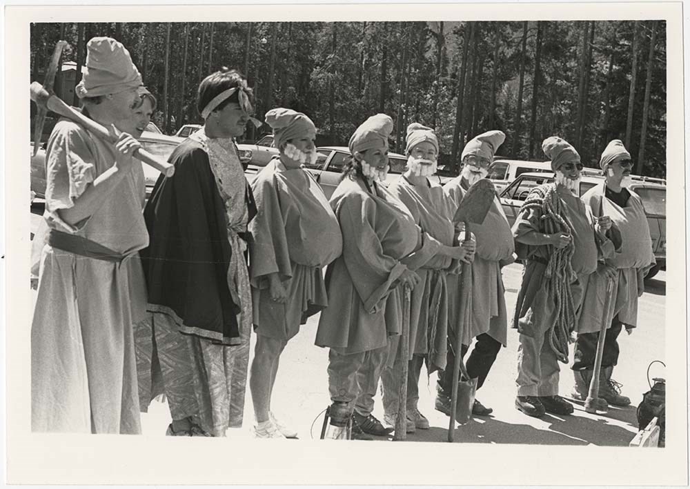
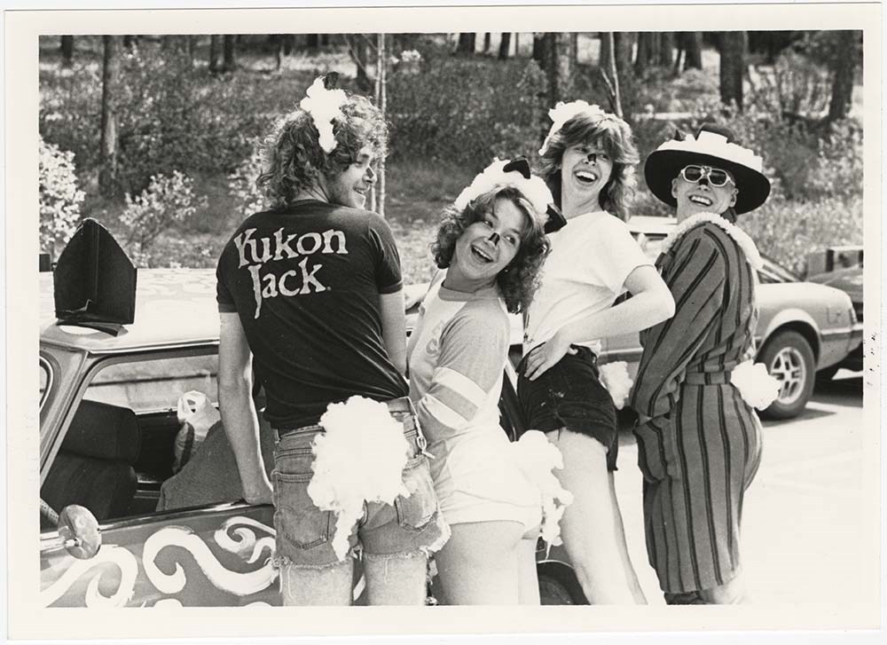
- Part Of
- Bruno Engler fonds
- Scope & Content
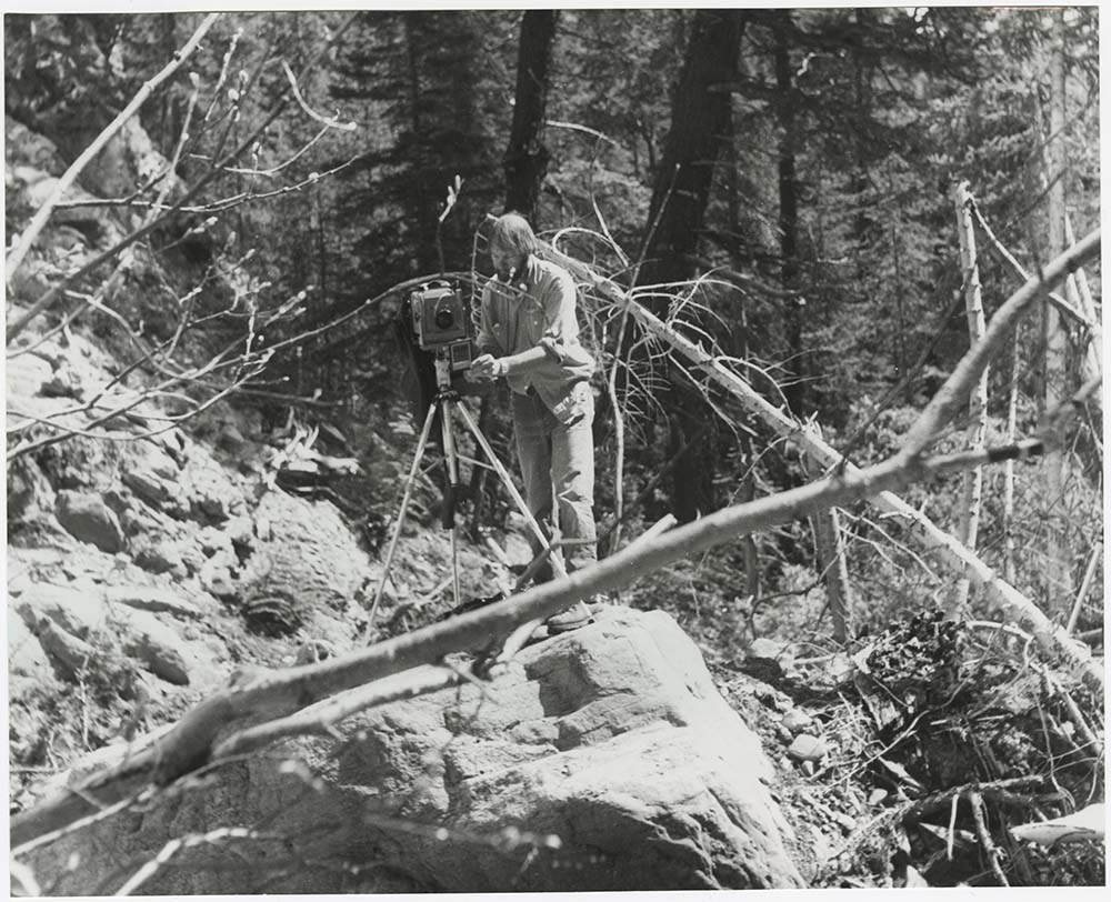
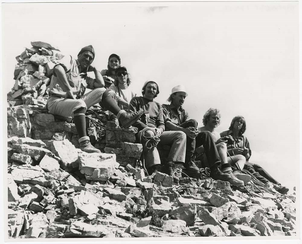
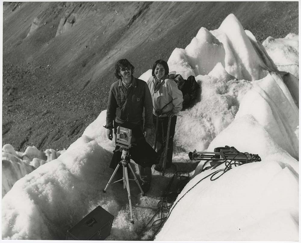
- File pertains to 59 b&w & colour prints of the Banff Centre. Includes interior and exterior shots of campus buildings and the 1980 Banff Centre Car Rally, the Banff Centre Wilderness Course from the mid-1970s - a course that combined mountaineering and photography, and portraits of Centre Director …
- Date Range
- [ca. 1974-1987]
- Reference Code
- V190 / VI / B / i / PA - 01 to PA - 59
- Description Level
- 5 / File
- GMD
- Photograph
- Textual record
10 images
- Part Of
- Bruno Engler fonds
- Description Level
- 5 / File
- Fonds Number
- M323 / S40 / V190
- Series
- VI : Retained file, B : Alphabetical order
- Sous-Fonds
- V190
- Sub-Series
- i : Banff Centre
- Accession Number
- 7436
- Reference Code
- V190 / VI / B / i / PA - 01 to PA - 59
- Date Range
- [ca. 1974-1987]
- Physical Description
- 59 photographs : b&w & col. ; 20.3 x 25.4 cm or smaller
- History / Biographical
- See fonds level description
- Scope & Content
- File pertains to 59 b&w & colour prints of the Banff Centre. Includes interior and exterior shots of campus buildings and the 1980 Banff Centre Car Rally, the Banff Centre Wilderness Course from the mid-1970s - a course that combined mountaineering and photography, and portraits of Centre Director Dr. Paul Fleck. Also includes newspaper clippings and documents pertaining to the High Altitude Wilderness Course.
- Name Access
- Fleck, Paul D.
- Gertsch, Rudy
- Subject Access
- Aerial photography
- Banff Centre
- Banff School of Fine Arts
- Buildings
- Climbing
- Community events
- Guides
- Mountains
- School
- Photography
- Portrait
- Theatre
- Geographic Access
- Banff
- Banff National Park
- Alberta
- Language
- English
- Creator
- Engler, Bruno
- Title Source
- Original title kept
- Processing Status
- Processed
Images


This material is presented as originally created; it may contain outdated cultural descriptions and
potentially offensive content.
Read more.
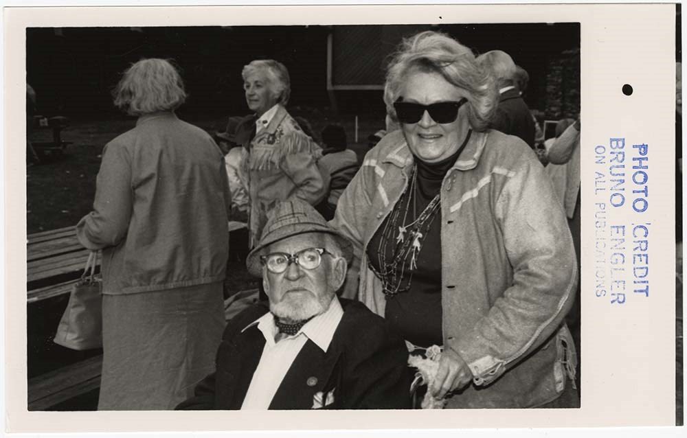
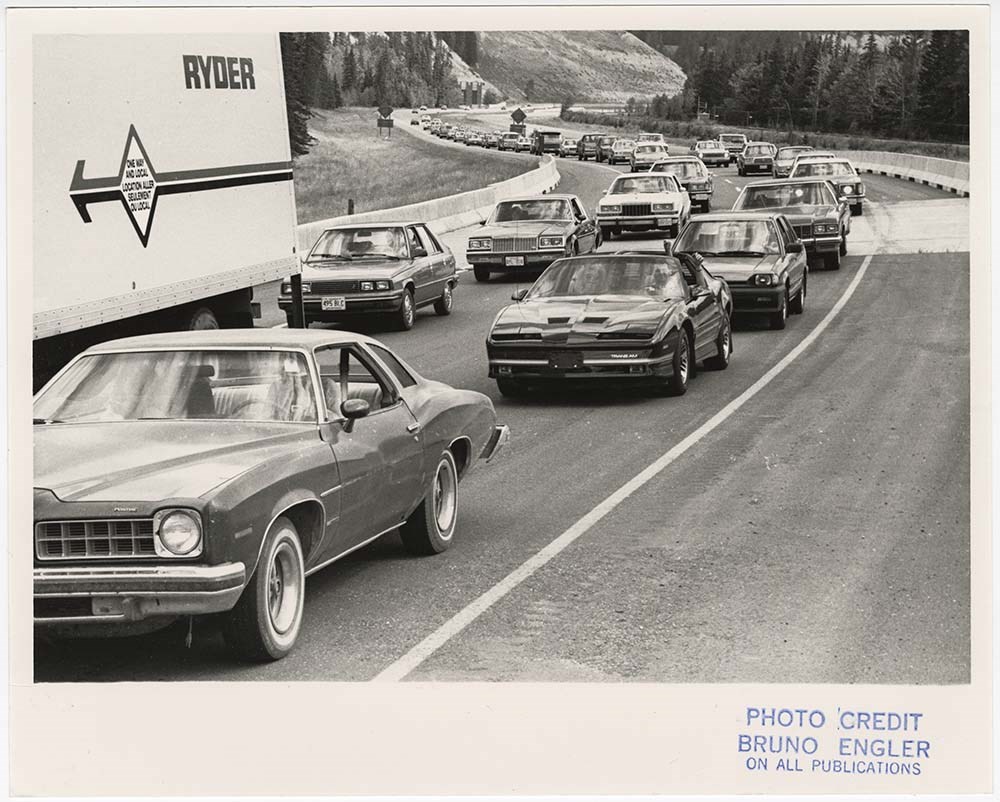
- Part Of
- Bruno Engler fonds
- Scope & Content
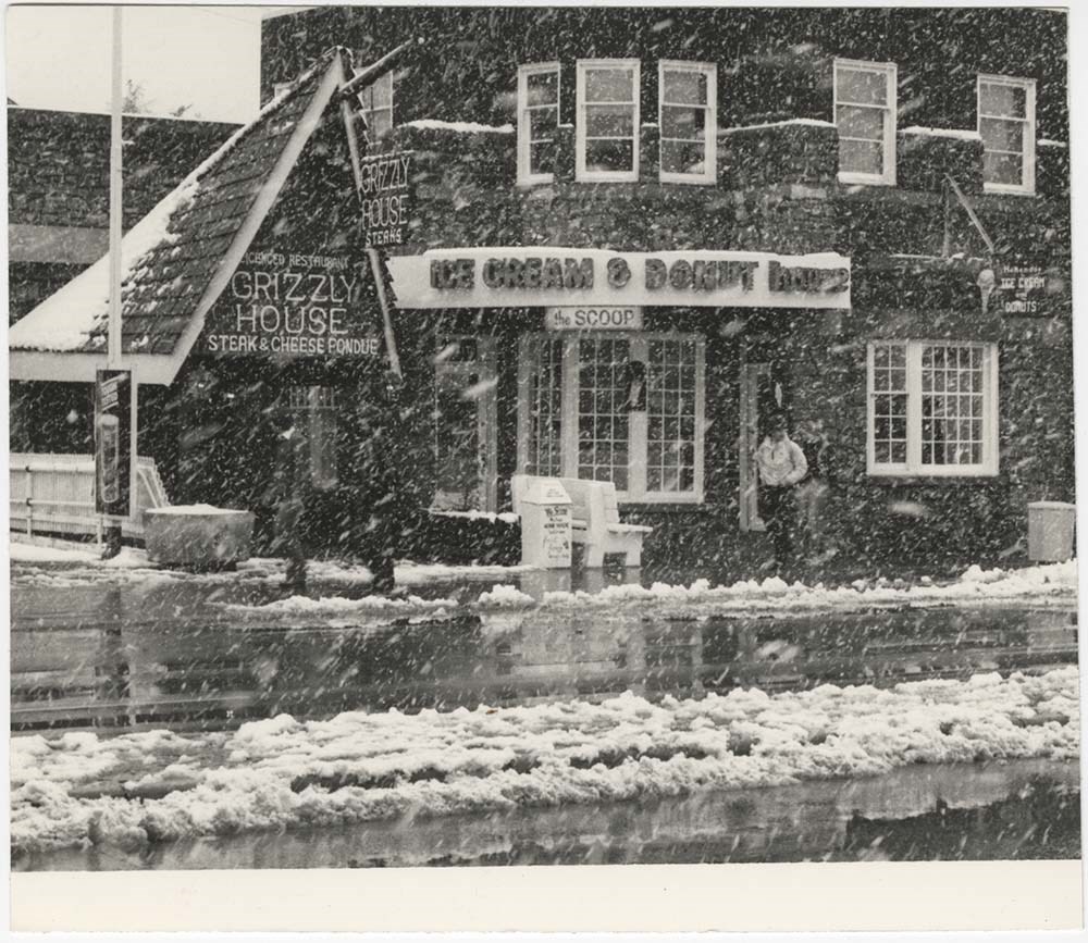
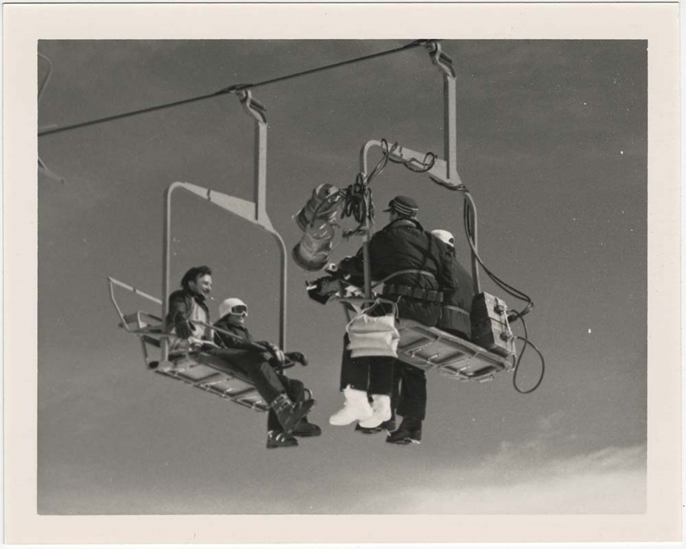
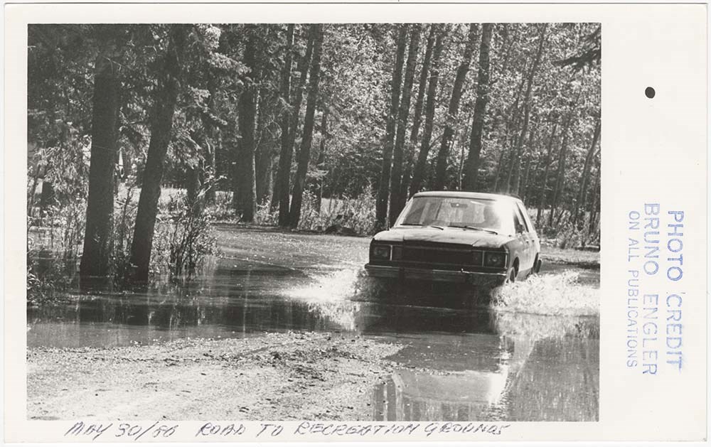
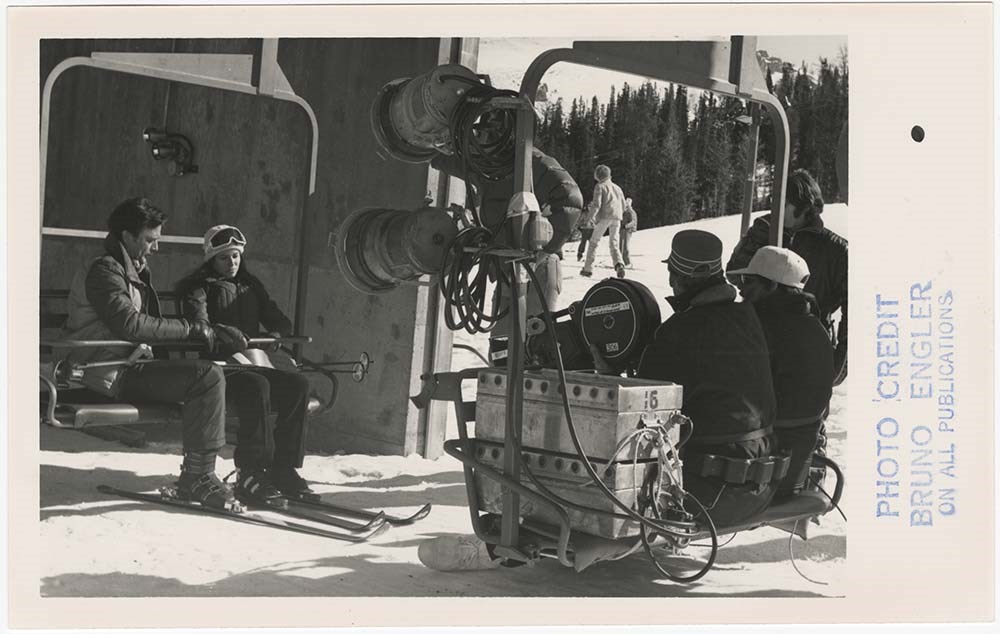
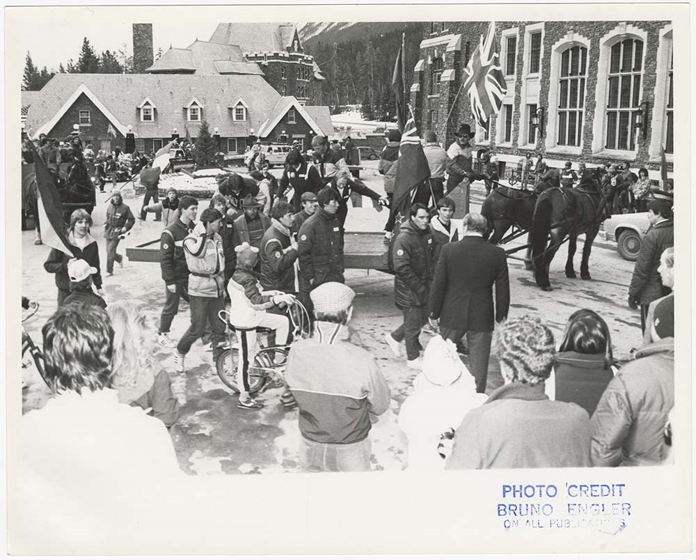
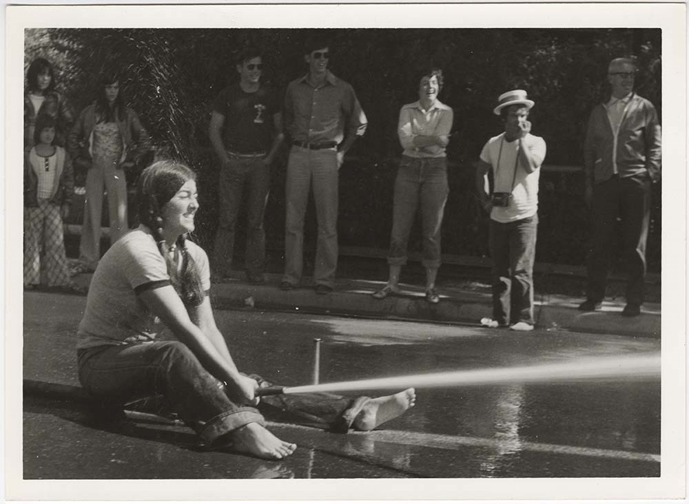
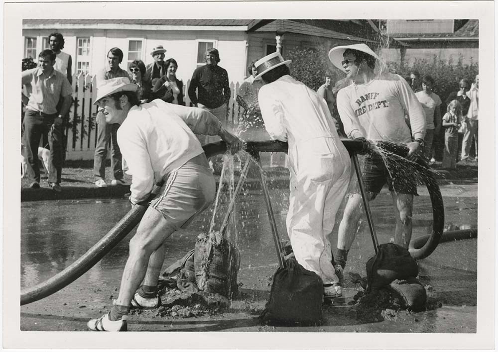
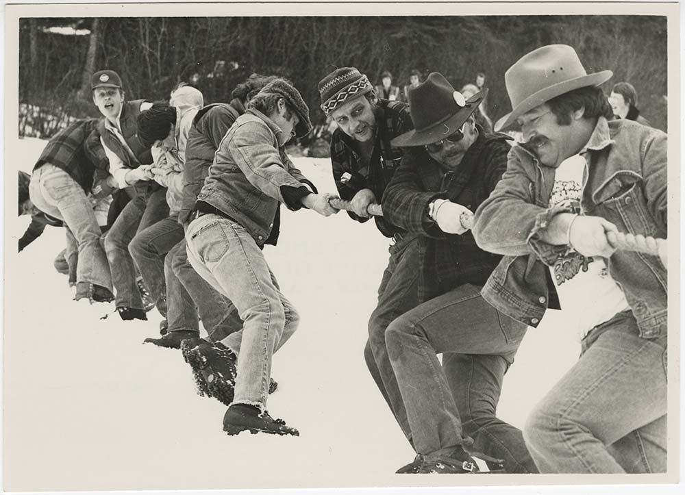
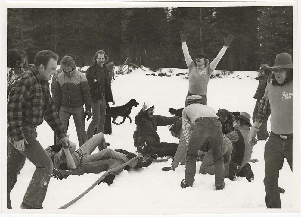
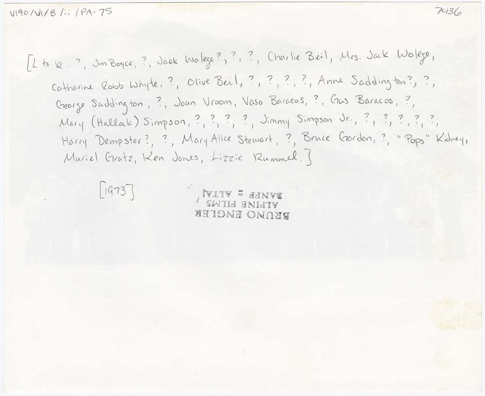
- File pertains to 136 b&w & colour prints of various Banff community events, including Back to Banff 1985, unseasonable snowfall, mild flooding of area around the recreation grounds and Buffalo Nation Museum, summer traffic jams, an unidentified parade, the designation of Mt. Jimmy Simpson, Banff Wi…
- Date Range
- [ca. 1965-1985]
- Reference Code
- V190 / VI / B / ii / PA - 01 to PA - 136
- Description Level
- 5 / File
- GMD
- Photograph
20 images
- Part Of
- Bruno Engler fonds
- Description Level
- 5 / File
- Fonds Number
- M323 / S40 / V190
- Series
- VI : Retained file, B : Alphabetical order
- Sous-Fonds
- V190
- Sub-Series
- ii : Banff Events
- Accession Number
- 7436
- Reference Code
- V190 / VI / B / ii / PA - 01 to PA - 136
- GMD
- Photograph
- Date Range
- [ca. 1965-1985]
- Physical Description
- 136 photographs : b&w & col. ; 25.2 x 20.2 cm or smaller
- History / Biographical
- See fonds level description
- Scope & Content
- File pertains to 136 b&w & colour prints of various Banff community events, including Back to Banff 1985, unseasonable snowfall, mild flooding of area around the recreation grounds and Buffalo Nation Museum, summer traffic jams, an unidentified parade, the designation of Mt. Jimmy Simpson, Banff Winter Carnival, RCMP Musical Ride, Banff Triathlon, and filming at Norquay Ski Hill.
- Name Access
- Beil, Charlie
- Boyd, Larry
- Carleton, Dorothy
- Carleton, Ed
- de Grandmaison, Sonia
- Hart, E. J. (Ted)
- Harvey, Ralph
- Madsen, Ken
- Rummel, Lizzie
- Simpson, Jimmy, Jr.
- Simpson, Mary (Hallock)
- Stewart, Maryalice Harvey
- Whyte, Catharine
- Wright, Scotty
- Subject Access
- Automobiles
- Back to Banff Day
- Banff Winter Carnival
- Buildings
- Businesses
- Banff townsite
- Community events
- Films and film making
- Norquay Ski Hill
- Parade
- Portrait
- Royal Canadian Mounted Police
- Ski areas
- Skiing
- Winter
- Winter sports
- Geographic Access
- Banff
- Banff National Park
- Alberta
- Language
- English
- Related Material
- V190 / VI / B / ii / NA - 01 to NA - 06
- Creator
- Engler, Bruno
- Title Source
- Original title kept
- Processing Status
- Processed
Images


This material is presented as originally created; it may contain outdated cultural descriptions and
potentially offensive content.
Read more.
Banff land use bylaw
https://archives.whyte.org/en/permalink/catalogue23276
- Medium
- Library - Maps and blueprints (unannotated; published)
- Map
- Published Date
- November 13, 1989
- Call Number
- C4-1.19
- Responsibility
- sgd. Barlow et al.
- Published Date
- November 13, 1989
- Physical Description
- 1 map
- Scale
- Scale: 1 : 5,000
- Subjects
- Banff townsite
- Call Number
- C4-1.19
- Collection
- Archives Library
This material is presented as originally created; it may contain outdated cultural descriptions and
potentially offensive content.
Read more.
Banff National Park (general)
https://archives.whyte.org/en/permalink/descriptions55338
- Part Of
- Murray Hay fonds
- Scope & Content
- File consists of 4 prings : col. 35.1 x 24.8 cm or smaller and 4 maps (2 paper, 2 overlays) : col., on mylar ; 60.4 x 30. cm or smaller. File pertains to aerial views of Banff National Park, showing the towns of Banff and Lake Louise, ski hills (Norqay Ski Hill, Sunshine Village, and Lake Louise Sk…
- Date Range
- ca.1976-ca.2000
- Reference Code
- V795 / II / B / v / 1-2
- Description Level
- 5 / File
- GMD
- Map
- Private record
- Part Of
- Murray Hay fonds
- Description Level
- 5 / File
- Fonds Number
- M570 / V795
- Series
- V795 / II : Unpublished Material
- Sous-Fonds
- V795
- Sub-Series
- V795 / II / B : Alberta / v : Banff National Park
- Accession Number
- 2019.41
- Reference Code
- V795 / II / B / v / 1-2
- GMD
- Map
- Private record
- Date Range
- ca.1976-ca.2000
- Physical Description
- 4 prints : col. 35.1 x 24.8 cm or smaller
- 4 maps (2 paper, 2 overlays) : col., annotations, on mylar ; 60.4 x 30. cm or smaller
- Scope & Content
- File consists of 4 prings : col. 35.1 x 24.8 cm or smaller and 4 maps (2 paper, 2 overlays) : col., on mylar ; 60.4 x 30. cm or smaller. File pertains to aerial views of Banff National Park, showing the towns of Banff and Lake Louise, ski hills (Norqay Ski Hill, Sunshine Village, and Lake Louise Ski Resort), as well as other georgraphic features. The mylar overlays contain various amounts of detail and annotations - one consists of a dark red sheet overlayed with place names in negative.
- Notes
- Items not in oversize stored in downstairs vault.
- Name Access
- Hay, Murray
- Subject Access
- Advertising
- Artist
- Ski Maps
- Map
- Cartography
- Sports and recreation
- Tourism
- Tourist information
- Winter
- Winter sports
- Ski area
- Sunshine Village
- Norquay Ski Hill
- Lake Louise Ski Area
- Geographic Access
- Banff
- Lake Louise
- Banff National Park
- Alberta
- Canada
- Canadian Rocky Mountains
- Language
- English
- Creator
- Hay, Murray
- Title Source
- Title based on contents of file
- Processing Status
- Processed
This material is presented as originally created; it may contain outdated cultural descriptions and
potentially offensive content.
Read more.
Banff natureguide : natural history and trail information, including maps of Banff Townsite & vicinity, Bow Valley area, Mountain Parks region
https://archives.whyte.org/en/permalink/catalogue24342
- Medium
- Library - Maps and blueprints (unannotated; published)
- Map
- Published Date
- 1983
- Publisher
- Calgary : Blackbird Naturographics
- Call Number
- C6-6.1b
- Publisher
- Calgary : Blackbird Naturographics
- Published Date
- 1983
- Physical Description
- 5 maps on 1 sheet : col
- Scale
- Scales vary
- Accession Number
- 16,500
- Call Number
- C6-6.1b
- Collection
- Archives Library
This material is presented as originally created; it may contain outdated cultural descriptions and
potentially offensive content.
Read more.
Banff natureguide : natural history and trail information, including maps of Banff Townsite & vicinity, Bow Valley area, Mountain Parks region
https://archives.whyte.org/en/permalink/catalogue23409
- Medium
- Library - Maps and blueprints (unannotated; published)
- Map
- Published Date
- 1983
- Publisher
- Calgary : Blackbird Naturographics
- Call Number
- C6-6.1b
- Publisher
- Calgary : Blackbird Naturographics
- Published Date
- 1983
- Physical Description
- 5 maps on 1 sheet : col
- Scale
- Scales vary
- Accession Number
- 16,500
- Call Number
- C6-6.1b
- Collection
- Archives Library
This material is presented as originally created; it may contain outdated cultural descriptions and
potentially offensive content.
Read more.
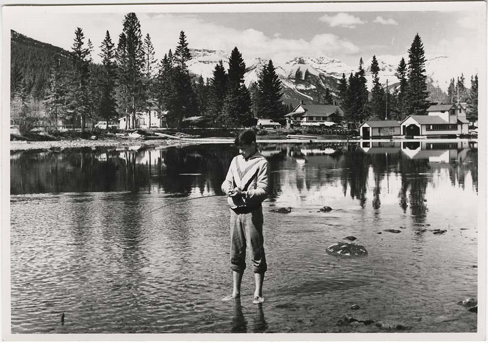
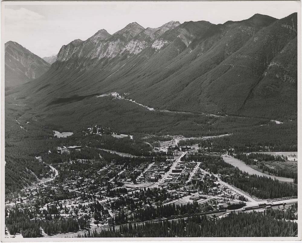
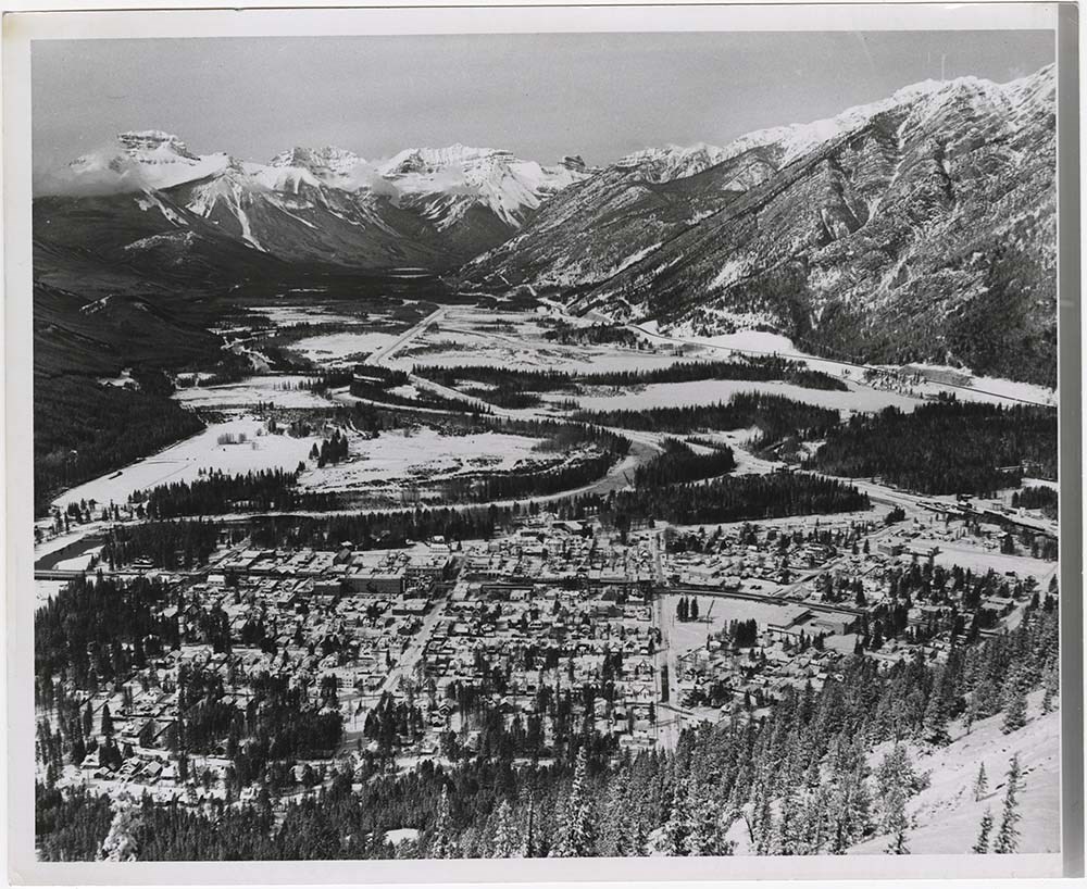
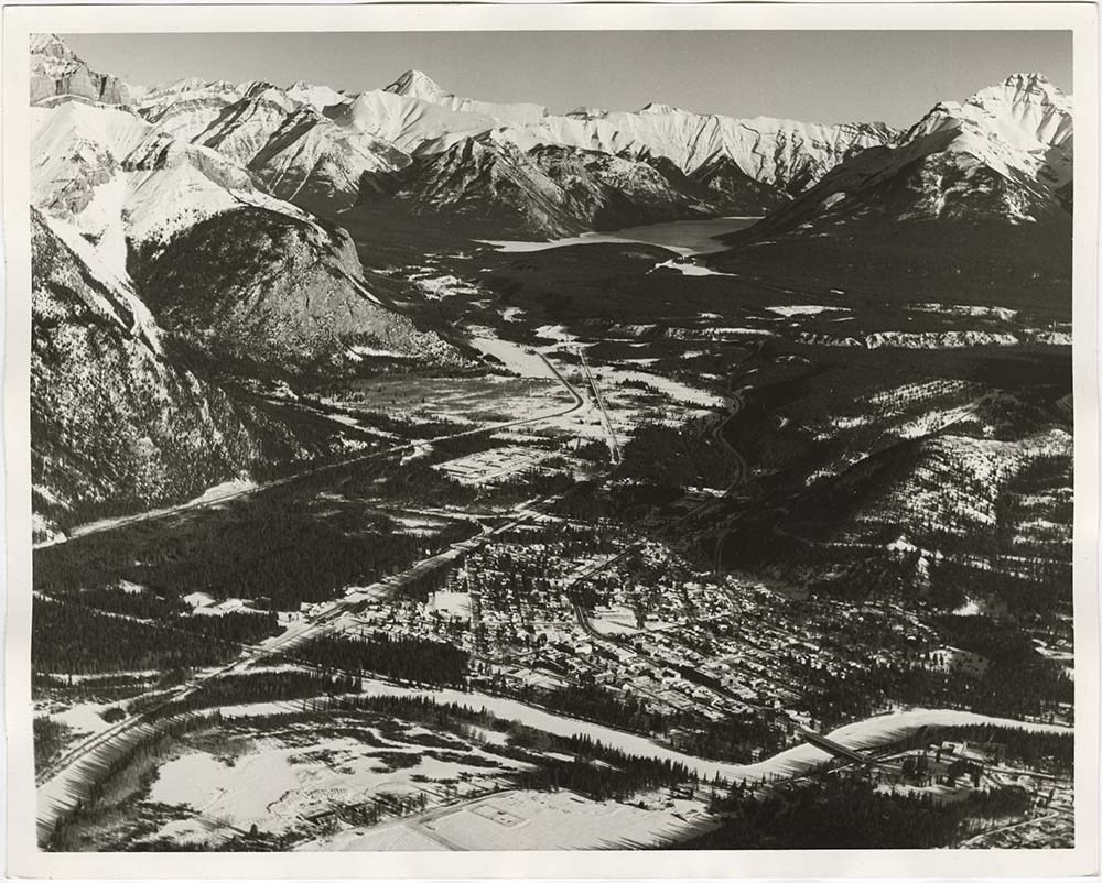
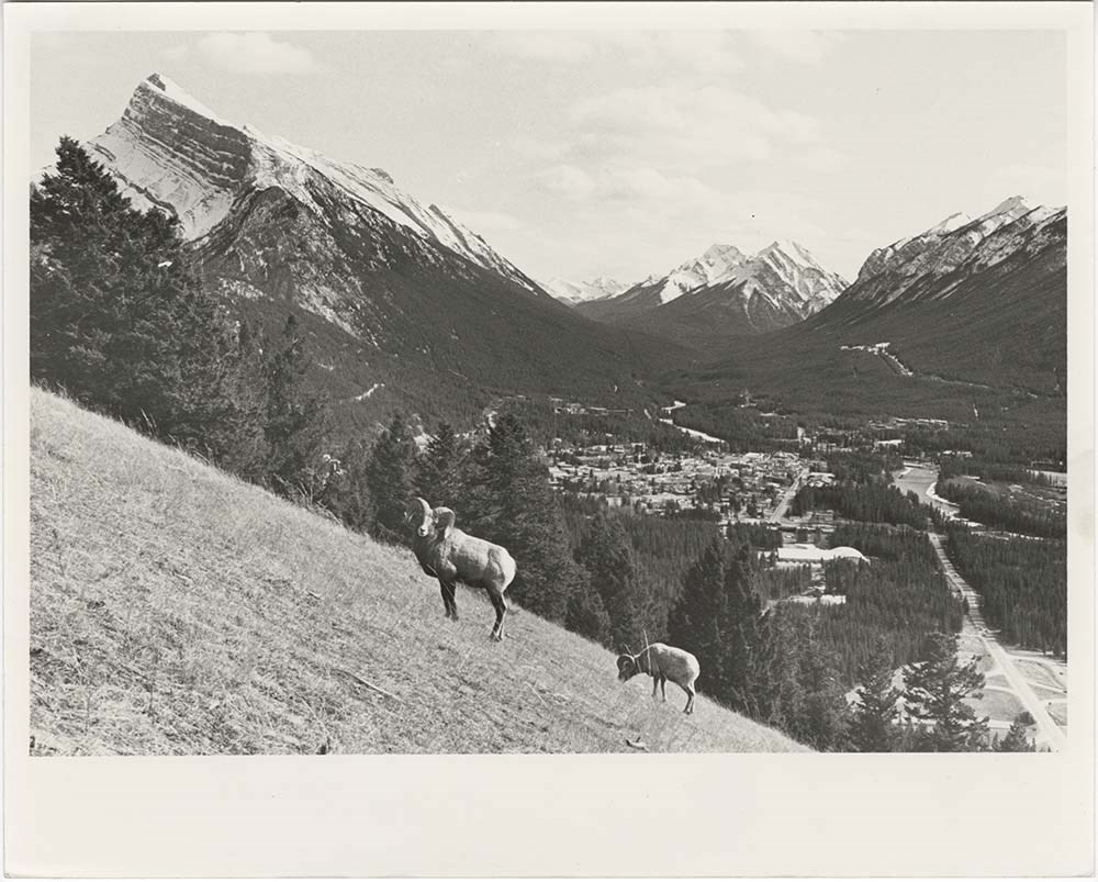
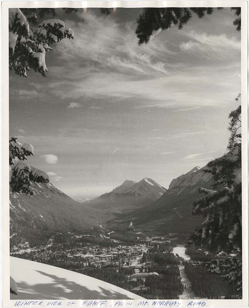
Banff Townsite
https://archives.whyte.org/en/permalink/descriptions57483
- Part Of
- Bruno Engler fonds
- Scope & Content
- File pertains to 30 b&w & colour prints of the Banff townsite from various angles, usually from Mount Norquay and Tunnel Mountain. Also includes shots of people at the opening of the Banff Upper Hot Springs, fishing in the river, and painting at Vermillion Lakes.
- Date Range
- 1959-1983
- Reference Code
- V190 / VI / B / ix / PA - 01 to PA - 30
- Description Level
- 5 / File
- GMD
- Photograph
11 images
- Part Of
- Bruno Engler fonds
- Description Level
- 5 / File
- Fonds Number
- M323 / S40 / V190
- Series
- VI : Retained file, B : Alphabetical order
- Sous-Fonds
- V190
- Sub-Series
- ix : Banff Townsite
- Accession Number
- 7436
- Reference Code
- V190 / VI / B / ix / PA - 01 to PA - 30
- GMD
- Photograph
- Date Range
- 1959-1983
- Physical Description
- 30 photographs : b&w & col. ; 25.2 x 20.2 cm or smaller
- History / Biographical
- See fonds level description
- Scope & Content
- File pertains to 30 b&w & colour prints of the Banff townsite from various angles, usually from Mount Norquay and Tunnel Mountain. Also includes shots of people at the opening of the Banff Upper Hot Springs, fishing in the river, and painting at Vermillion Lakes.
- Subject Access
- Activities
- Animals
- Aerial photography
- Artist
- Banff townsite
- Banff Upper Hot Springs
- Big Horn Sheep
- Bow River
- Bow River Boat House
- Buildings
- Fishing
- Mountains
- scenic
- Winter
- Geographic Access
- Banff
- Banff National Park
- Alberta
- Language
- English
- Creator
- Engler, Bruno
- Title Source
- Original title kept
- Processing Status
- Processed
Images


This material is presented as originally created; it may contain outdated cultural descriptions and
potentially offensive content.
Read more.
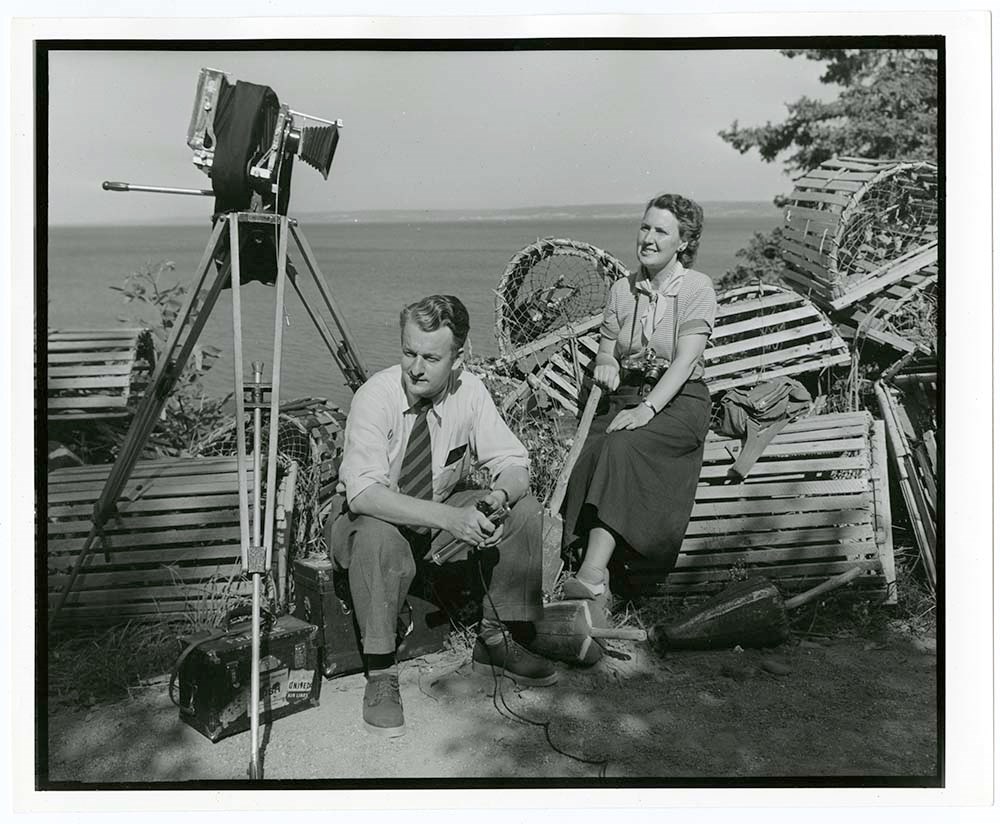
- Part Of
- Nicholas Morant fonds
- Scope & Content
- File pertains to BC museum train, Canadian Pacific Railway. Includes two sets labelled: BC museum train, key set, April 1'78, 14 items; BC train 2860, April 1'78, 9 items
- Date Range
- [between 1930 and 1980]
- Reference Code
- V500 / C1 / 6
- Description Level
- 5 / File
- GMD
2 images
- Part Of
- Nicholas Morant fonds
- Description Level
- 5 / File
- Fonds Number
- M300 / S20 / V500
- Series
- I.C. Photography : prints
- Sous-Fonds
- V500
- Accession Number
- .
- Reference Code
- V500 / C1 / 6
- GMD
- Date Range
- [between 1930 and 1980]
- Physical Description
- 23 photographs : prints, b/w
- Scope & Content
- File pertains to BC museum train, Canadian Pacific Railway. Includes two sets labelled: BC museum train, key set, April 1'78, 14 items; BC train 2860, April 1'78, 9 items
- Notes
- NM note: fibre-based prints made by Nicholas Morant
- Geographic Access
- British Columbia
- Processing Status
- Processed
Images

This material is presented as originally created; it may contain outdated cultural descriptions and
potentially offensive content.
Read more.
Belcourt Lake, British Columbia
https://archives.whyte.org/en/permalink/catalogue23495
- Medium
- Library - Maps and blueprints (unannotated; published)
- Map
- Published Date
- 1986
- Publisher
- Ottawa : Surveys and Mapping Branch
- Call Number
- NTS
- 93I/8
- Publisher
- Ottawa : Surveys and Mapping Branch
- Published Date
- 1986
- Physical Description
- 1 map : col
- Scale
- Scale: 1:50,000
- Accession Number
- 24,000
- Call Number
- NTS
- 93I/8
- Collection
- Archives Library
This material is presented as originally created; it may contain outdated cultural descriptions and
potentially offensive content.
Read more.
Big White Ski Resort
https://archives.whyte.org/en/permalink/descriptions54877
- Part Of
- Murray Hay fonds
- Scope & Content
- File consists of 2 prints : col ; 35 x 28 cm. File pertains to Murray Hay's rendering of the ski area at Big White Ski Resort in Kelowna, British Columbia. File includes two unlabelled, draft print reproductions of original paintings.
- Date Range
- ca.1976-ca.2000
- Reference Code
- V795 / II / A / iv / 5
- Description Level
- 5 / File
- GMD
- Map
- Private record
- Part Of
- Murray Hay fonds
- Description Level
- 5 / File
- Fonds Number
- M570 / V795
- Series
- V795 / II : Unpublished Material
- Sous-Fonds
- V795
- Sub-Series
- V795 / II / A : British Columbia / iv : Okanagan Area
- Accession Number
- 2019.41
- Reference Code
- V795 / II / A / iv / 5
- GMD
- Map
- Private record
- Date Range
- ca.1976-ca.2000
- Physical Description
- 2 prints : col. ; 35 x 28 cm
- Scope & Content
- File consists of 2 prints : col ; 35 x 28 cm. File pertains to Murray Hay's rendering of the ski area at Big White Ski Resort in Kelowna, British Columbia. File includes two unlabelled, draft print reproductions of original paintings.
- Name Access
- Hay, Murray
- Subject Access
- Ski Maps
- Map
- Cartography
- Ski area
- Tourism
- Tourist information
- Winter
- Winter sports
- Sports and recreation
- Big White Ski Area
- Art
- Artist
- Geographic Access
- Kelowna
- British Columbia
- Canada
- Language
- English
- Related Material
- M570 / III / A / v / 1
- Creator
- Hay, Murray
- Category
- Sports, recreation and leisure
- Title Source
- Title based on contents of file
- Processing Status
- Processed
This material is presented as originally created; it may contain outdated cultural descriptions and
potentially offensive content.
Read more.
Blue Creek, Alberta
https://archives.whyte.org/en/permalink/catalogue23502
- Medium
- Library - Maps and blueprints (unannotated; published)
- Map
- Published Date
- 1981
- Publisher
- [Ottawa]: Surveys an Mapping Branch, Dept. of Energy, Mines and Resources
- Edition
- 3rd edition
- Call Number
- NTS
- 83E/7
- Edition
- 3rd edition
- Publisher
- [Ottawa]: Surveys an Mapping Branch, Dept. of Energy, Mines and Resources
- Published Date
- 1981
- Physical Description
- 1 map : col
- Scale
- 1:50,000
- Accession Number
- 27,000
- Call Number
- NTS
- 83E/7
- Collection
- Archives Library
This material is presented as originally created; it may contain outdated cultural descriptions and
potentially offensive content.
Read more.
Blue River 83D/3 B.C.
https://archives.whyte.org/en/permalink/catalogue23507
- Medium
- Library - Maps and blueprints (unannotated; published)
- Map
- Published Date
- 1986
- Publisher
- Surveys and Mapping Branch, Dept. of Energy, Mines and Resources
- Edition
- 3rd ed.
- Call Number
- NTS
- 83D/3
- Edition
- 3rd ed.
- Publisher
- Surveys and Mapping Branch, Dept. of Energy, Mines and Resources
- Published Date
- 1986
- Physical Description
- 1 map : col
- Scale
- Scale: 1:50,000
- Relief: Contour interval 100 feet
- Subjects
- Blue River
- British Columbia
- Notes
- National Topographic System
- Accession Number
- 19,000
- Call Number
- NTS
- 83D/3
- Collection
- Archives Library
This material is presented as originally created; it may contain outdated cultural descriptions and
potentially offensive content.
Read more.
[Bluewater Creek, B.C.]
https://archives.whyte.org/en/permalink/catalogue23509
- Medium
- Library - Maps and blueprints (unannotated; published)
- Map
- Published Date
- 1980
- Publisher
- Dept. of Energy, Mines and Resources
- Edition
- Edition 2
- Call Number
- NTS
- 82N/11
- Edition
- Edition 2
- Publisher
- Dept. of Energy, Mines and Resources
- Published Date
- 1980
- Physical Description
- 1 map : col
- Scale
- Scale: 1:50,000
- Relief: Contour Interval 100 ft.
- Subjects
- Bluewater Creek
- British Columbia
- Notes
- National Topographic System
- Accession Number
- 12,000
- 7030
- Call Number
- NTS
- 82N/11
- Collection
- Archives Library
This material is presented as originally created; it may contain outdated cultural descriptions and
potentially offensive content.
Read more.
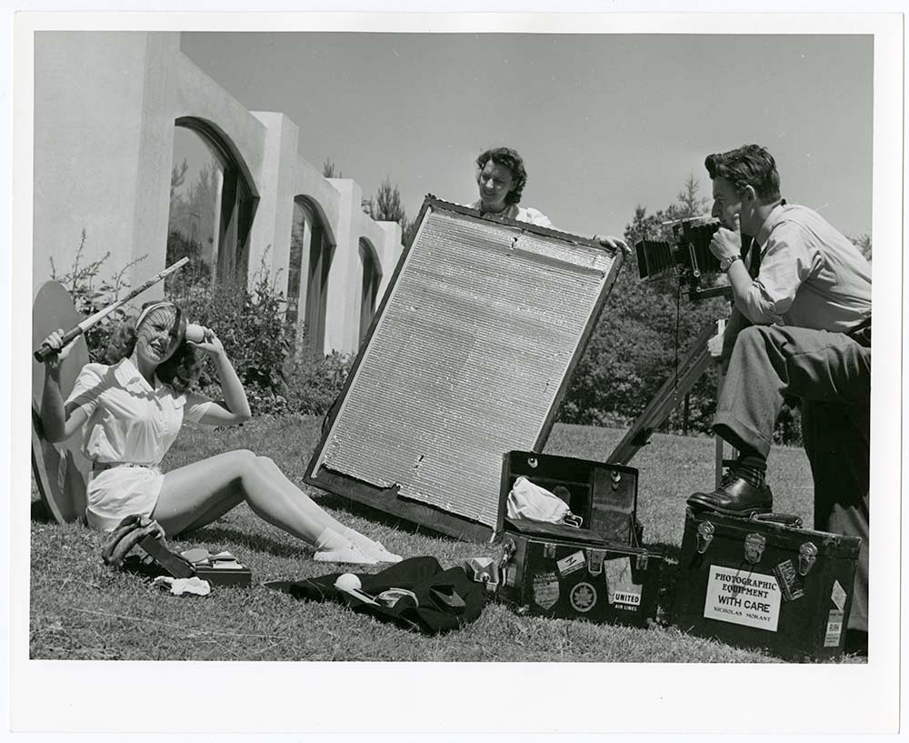
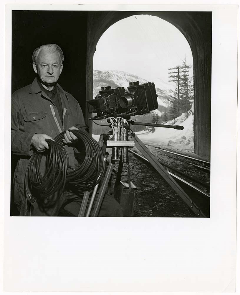
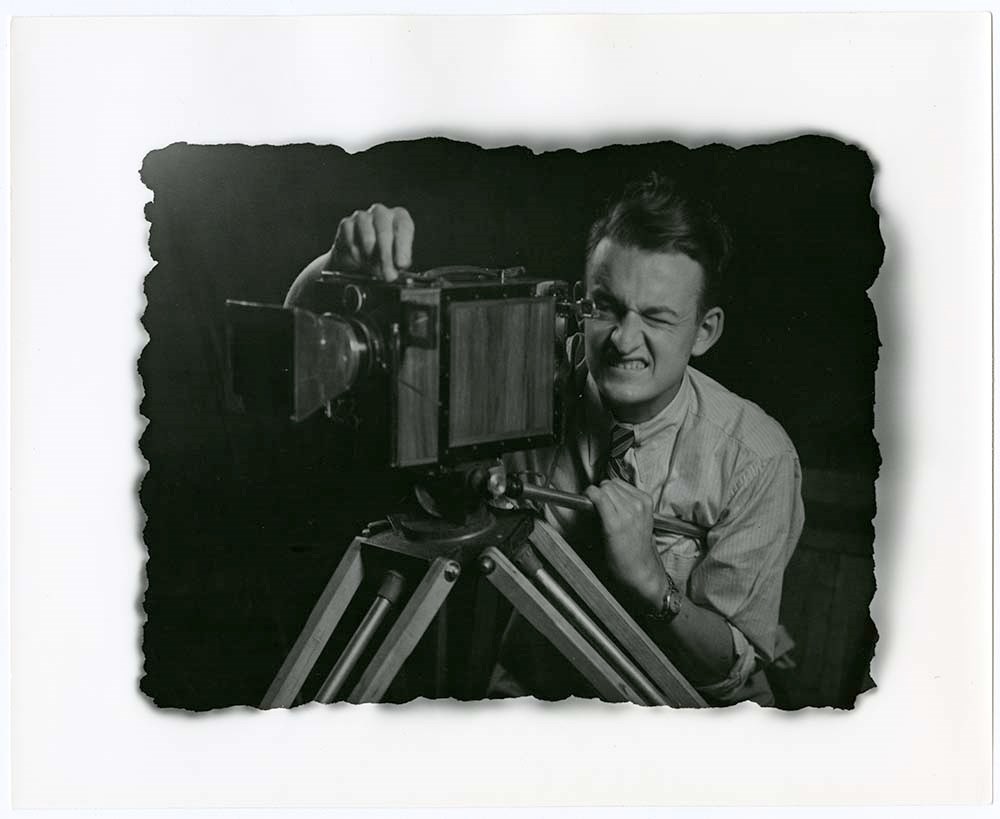
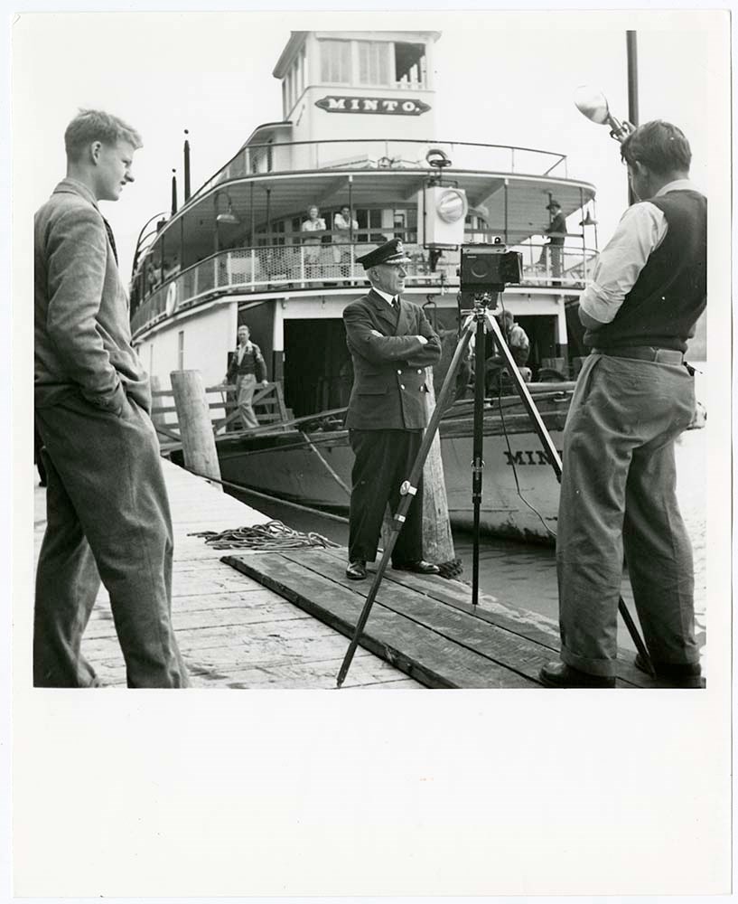
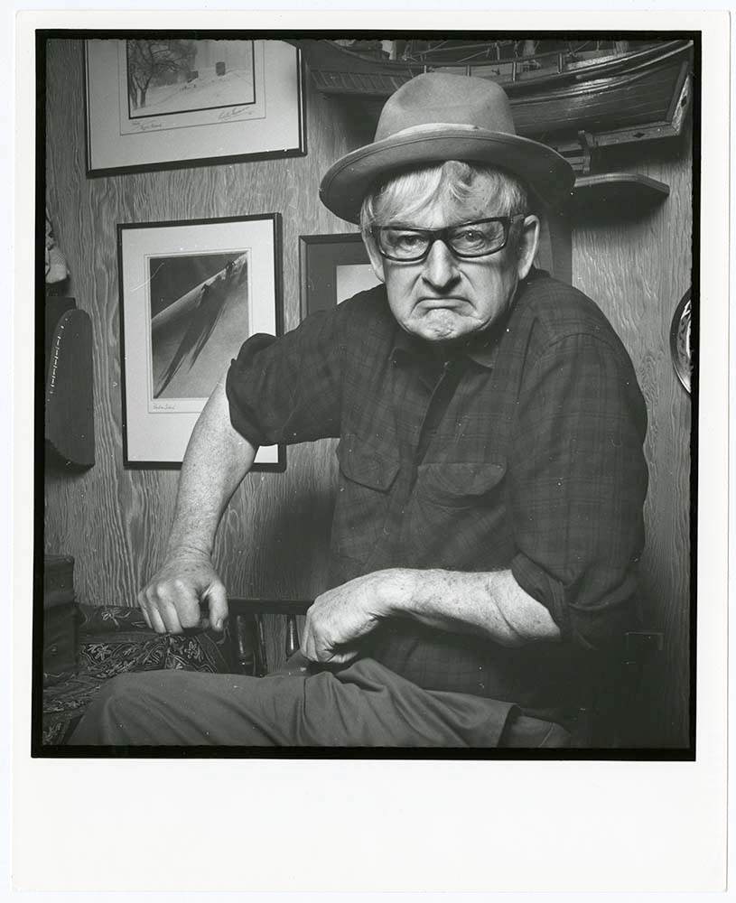
Book - Personalities
https://archives.whyte.org/en/permalink/descriptions21604
- Part Of
- Nicholas Morant fonds
- Scope & Content
- File contains variety of views assembled for book use. Content pertains to Nick Morant at work, Willie Morant, railways, hotels, ships, people at work
- Date Range
- [between 1930 and 1980]
- Reference Code
- V500 / C1 / 8, 9
- Description Level
- 5 / File
- GMD
7 images
- Part Of
- Nicholas Morant fonds
- Description Level
- 5 / File
- Fonds Number
- M300 / S20 / V500
- Series
- I.C. Photography : prints
- Sous-Fonds
- V500
- Accession Number
- .
- Reference Code
- V500 / C1 / 8, 9
- GMD
- Date Range
- [between 1930 and 1980]
- Physical Description
- 45 photographs : prints, b/w
- Scope & Content
- File contains variety of views assembled for book use. Content pertains to Nick Morant at work, Willie Morant, railways, hotels, ships, people at work
- Geographic Access
- Canada
- Processing Status
- Processed
Images
This material is presented as originally created; it may contain outdated cultural descriptions and
potentially offensive content.
Read more.
- Part Of
- Luxton family fonds
- Scope & Content
- File consists of one colour photograph depicting a view of Bow Lake, taken in October 1983.
- Date Range
- 1983
- Reference Code
- LUX / III / A3c / PA - 1
- Description Level
- 5 / File
- GMD
- Photograph
- Part Of
- Luxton family fonds
- Description Level
- 5 / File
- Fonds Number
- LUX
- Series
- LUX / III / A : Norman Luxton family
- Sous-Fonds
- LUX / III : Luxton family sous-fonds
- Sub-Series
- LUX / III / A3 : Collected material
- Accession Number
- LUX
- Reference Code
- LUX / III / A3c / PA - 1
- GMD
- Photograph
- Date Range
- 1983
- Physical Description
- 1 photograph : col. print ; 10 x 10 cm
- Scope & Content
- File consists of one colour photograph depicting a view of Bow Lake, taken in October 1983.
- Notes
- Photograph is annotated on back: "Bow Lakes Oct. /83"
- Subject Access
- Environment
- Landscapes
- Mountains
- Geographic Access
- Canada
- Alberta
- Banff National Park
- Bow Lake
- Language
- English
- Conservation
- Item stored in mylar
- Category
- Environment
- Title Source
- Title based on contents of file
- Processing Status
- Processed
This material is presented as originally created; it may contain outdated cultural descriptions and
potentially offensive content.
Read more.
Brewster house
https://archives.whyte.org/en/permalink/descriptions55681
- Part Of
- Maryalice Harvey Stewart fonds
- Scope & Content
- File consists of 14 photographs depicting interior and exterior views of the Brewster family residence in Banff, ca. 1981.
- Date Range
- 1981
- Reference Code
- V605 / I / B / PA - 1 to 14
- Description Level
- 5 / File
- GMD
- Photograph
- Part Of
- Maryalice Harvey Stewart fonds
- Description Level
- 5 / File
- Fonds Number
- M9
- S13
- V605
- Series
- V605 / I : Professional records
- Sous-Fonds
- V605
- Sub-Series
- V605 / I / B : Research and other professional records
- Accession Number
- 1300
- 7412
- Reference Code
- V605 / I / B / PA - 1 to 14
- GMD
- Photograph
- Date Range
- 1981
- Physical Description
- 14 photographs : b&w and col. prints ; 25 x 20 cm and 8.5 x 8.5 cm
- Scope & Content
- File consists of 14 photographs depicting interior and exterior views of the Brewster family residence in Banff, ca. 1981.
- Notes
- Original envelope stored in file, annotated on back: "Brewster House Fall 1981???"
- Geographic Access
- Canada
- Alberta
- Banff
- Reproduction Restrictions
- Copyright status unknown
- Language
- English
- Related Material
- M9 / I / B / 10
- Title Source
- Original title from storage envelope used
- Processing Status
- Processed
This material is presented as originally created; it may contain outdated cultural descriptions and
potentially offensive content.
Read more.
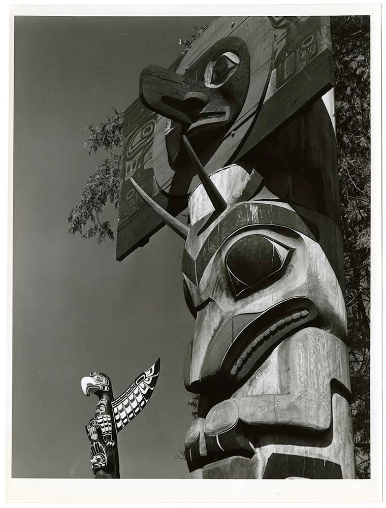
British Columbia and Pacific Coast
https://archives.whyte.org/en/permalink/descriptions21579
- Part Of
- Nicholas Morant fonds
- Scope & Content
- File pertains to scenic views, cities and town, buildings, bridges, ships and boats, totems poles. Includes the following areas: Revelstoke, Kamloops, Thompson Rivers, Nelson, Emerald Lake, Ashcroft, Vancouver, Vancouver Island, Victoria, north coastal BC
- Date Range
- [between 1930 and 1980]
- Reference Code
- V500 / C1 / 10, 11
- Description Level
- 5 / File
- GMD
2 images
- Part Of
- Nicholas Morant fonds
- Description Level
- 5 / File
- Fonds Number
- M300 / S20 / V500
- Series
- I.C. Photography : prints
- Sous-Fonds
- V500
- Reference Code
- V500 / C1 / 10, 11
- GMD
- Date Range
- [between 1930 and 1980]
- Physical Description
- 43 photographs : prints, b/w
- Scope & Content
- File pertains to scenic views, cities and town, buildings, bridges, ships and boats, totems poles. Includes the following areas: Revelstoke, Kamloops, Thompson Rivers, Nelson, Emerald Lake, Ashcroft, Vancouver, Vancouver Island, Victoria, north coastal BC
- Notes
- NM note: fibre-based prints made by Nicholas Morant
- Geographic Access
- British Columbia
- Processing Status
- Processed
Images

This material is presented as originally created; it may contain outdated cultural descriptions and
potentially offensive content.
Read more.