Narrow Results By
AAF aeronautical chart : North Saskatchewan River / compiled for the U.S. Army Air Forces by the U.S. Coast and Geodetic Survey
https://archives.whyte.org/en/permalink/catalogue24364
- Medium
- Library - Maps and blueprints (unannotated; published)
- Map
- Published Date
- 1943
- Publisher
- Washington, D.C.
- Call Number
- C6-12.1
- Publisher
- Washington, D.C.
- Published Date
- 1943
- Physical Description
- 1 map : col
- Scale
- 1 : 1,000,000
- Subjects
- Saskatchewan River, North
- Aviation
- Accession Number
- 4008
- Call Number
- C6-12.1
- Collection
- Archives Library
This material is presented as originally created; it may contain outdated cultural descriptions and
potentially offensive content.
Read more.
Alaska as a frontier of defence to Japan
https://archives.whyte.org/en/permalink/catalogue21517
- Medium
- Library - Maps and blueprints (unannotated; published)
- Map
- Published Date
- August 2, 1942
- Publisher
- Victoria newspaper
- Call Number
- C13-1.16
- Publisher
- Victoria newspaper
- Published Date
- August 2, 1942
- Subjects
- Alaska, United States
- Notes
- Article from Victoria newspaper
- Accession Number
- 400
- Call Number
- C13-1.16
- Collection
- Archives Library
This material is presented as originally created; it may contain outdated cultural descriptions and
potentially offensive content.
Read more.
[Banff - Sketch plan of Banff townsite]
https://archives.whyte.org/en/permalink/catalogue23259
- Medium
- Library - Maps and blueprints (unannotated; published)
- Map
- Published Date
- 1940
- Publisher
- Department of Mines and Resources
- Call Number
- C4-1.5
- Publisher
- Department of Mines and Resources
- Published Date
- 1940
- Physical Description
- 1 map : black and white
- Scale
- Scale: 400' = 1"
- Subjects
- Banff townsite
- Notes
- Duplicate - Map Room - Accn. 1038, 2933
- Accession Number
- 1161
- 1038
- 2933
- Call Number
- C4-1.5
- Collection
- Archives Library
This material is presented as originally created; it may contain outdated cultural descriptions and
potentially offensive content.
Read more.
[Blairmore 82G/9 West, Alberta]
https://archives.whyte.org/en/permalink/catalogue23501
- Medium
- Library - Maps and blueprints (unannotated; published)
- Map
- Published Date
- 1946
- Publisher
- Dept. of Mines and Techinical Surveys
- Call Number
- NTS
- 82G/9W
- Publisher
- Dept. of Mines and Techinical Surveys
- Published Date
- 1946
- Physical Description
- 1 map : col
- Scale
- Scale: 1:50,000
- Relief: Contour interval 100'
- Subjects
- Blairmore
- Western Alberta
- Notes
- National Topographic System
- Call Number
- NTS
- 82G/9W
- Collection
- Archives Library
This material is presented as originally created; it may contain outdated cultural descriptions and
potentially offensive content.
Read more.
[BRIDGE PLAN #1 - Plan of Proposed Bridge Site for Healy Creek at mile 4.2] (3)
https://archives.whyte.org/en/permalink/catalogue23236
- Medium
- Library - Maps and blueprints (unannotated; published)
- Map
- Published Date
- Dec. 14, 1946/Jan. 14, 1947
- Publisher
- Engineering and Construction Service, Surveys and Engineering Branch, Dept. of Mines and Resources, Banff, Alta.
- Call Number
- C2-10.1 (d)
- Publisher
- Engineering and Construction Service, Surveys and Engineering Branch, Dept. of Mines and Resources, Banff, Alta.
- Published Date
- Dec. 14, 1946/Jan. 14, 1947
- Scale
- Scale: 1 ": 40 ft.
- Relief: Counter interval 2ft.
- Subjects
- Mount Assiniboine Provincial Park
- Notes
- 4) BRIDGE PLAN #2- Plan of Proposed Bridge Site for Healy Creek at Mile 9.8
- Healy Creek - Mt. Assiniboine Highway survey by K.R. Ford
- Accession Number
- 2158
- Call Number
- C2-10.1 (d)
- Collection
- Archives Library
This material is presented as originally created; it may contain outdated cultural descriptions and
potentially offensive content.
Read more.
[British Columbia, Highways] Alberta Motor Association
https://archives.whyte.org/en/permalink/catalogue24512
- Medium
- Library - Maps and blueprints (unannotated; published)
- Map
- Published Date
- 1941
- Call Number
- C10-1.1
- Published Date
- 1941
- Scale
- 1 inch-40 miles
- Subjects
- British Columbia
- Highways
- Notes
- Tourist information for 1941 on reverse side of map
- Accession Number
- 400
- Call Number
- C10-1.1
- Collection
- Archives Library
This material is presented as originally created; it may contain outdated cultural descriptions and
potentially offensive content.
Read more.
[British North America]
https://archives.whyte.org/en/permalink/catalogue21421
- Medium
- Library - Maps and blueprints (unannotated; published)
- Map
- Published Date
- 1754-1761
- Publisher
- Canadian Geographic Journal (Public Archives of Canada)
- Call Number
- C11-1.2
- Publisher
- Canadian Geographic Journal (Public Archives of Canada)
- Published Date
- 1754-1761
- Subjects
- British North America
- Accession Number
- 495
- Call Number
- C11-1.2
- Collection
- Archives Library
This material is presented as originally created; it may contain outdated cultural descriptions and
potentially offensive content.
Read more.
[Callum Creek 82G/16 East, Alberta]
https://archives.whyte.org/en/permalink/catalogue23528
- Medium
- Library - Maps and blueprints (unannotated; published)
- Map
- Published Date
- 1943
- Publisher
- Dept. of Mines and Technical Surveys
- Call Number
- NTS
- 82G/16E
- Publisher
- Dept. of Mines and Technical Surveys
- Published Date
- 1943
- Physical Description
- 1 map : black and white
- Scale
- Scale: 1:50,000
- Relief: Contour interval 100'
- Subjects
- Callum Creek
- Alberta
- Notes
- National Topographic System
- Call Number
- NTS
- 82G/16E
- Collection
- Archives Library
This material is presented as originally created; it may contain outdated cultural descriptions and
potentially offensive content.
Read more.
Canal topography from Lake Minnewanka to the sink.
https://archives.whyte.org/en/permalink/catalogue23362
- Medium
- Library - Maps and blueprints (unannotated; published)
- Map
- Published Date
- July 16, 1941 (revised August 8, 1941)
- Call Number
- C5-6.27(b)
- Published Date
- July 16, 1941 (revised August 8, 1941)
- Scale
- 1" = 100'
- Subjects
- Calgary Power Co. Ltd.
- Hydrology
- Notes
- (rolled on top of map case)
- Accession Number
- 3079
- Call Number
- C5-6.27(b)
- Collection
- Archives Library
This material is presented as originally created; it may contain outdated cultural descriptions and
potentially offensive content.
Read more.
Cascade Development Sketch Plan of the Ghost River Diversion
https://archives.whyte.org/en/permalink/catalogue23361
- Medium
- Library - Maps and blueprints (unannotated; published)
- Map
- Published Date
- March 31, 1941
- Call Number
- C5-6.27(a)
- Published Date
- March 31, 1941
- Scale
- 1" - 1000'
- Subjects
- Calgary Power Co. Ltd.
- Hydrology
- Notes
- A sketch plan showing approximate surface features of country between Ghost River and Lake Minnewanka
- Accession Number
- 3079
- Call Number
- C5-6.27(a)
- Collection
- Archives Library
This material is presented as originally created; it may contain outdated cultural descriptions and
potentially offensive content.
Read more.
Central British Columbia
https://archives.whyte.org/en/permalink/catalogue24534
- Medium
- Library - Maps and blueprints (unannotated; published)
- Map
- Published Date
- 1940
- Publisher
- Dept. of Lands, B.C.
- Call Number
- C10-6.5
- Publisher
- Dept. of Lands, B.C.
- Published Date
- 1940
- Scale
- Scale: 1:1,000,000
- Subjects
- Central British Columbia
- Accession Number
- 540
- 3349?
- Call Number
- C10-6.5
- Collection
- Archives Library
This material is presented as originally created; it may contain outdated cultural descriptions and
potentially offensive content.
Read more.
Classical Lands of the Mediterranean
https://archives.whyte.org/en/permalink/catalogue24862
- Medium
- Library - Maps and blueprints (unannotated; published)
- Map
- Published Date
- 1940
- Publisher
- National Geographic Society
- Call Number
- C13-12.14
- Publisher
- National Geographic Society
- Published Date
- 1940
- Scale
- Scale: 35 miles to 1 inch
- Relief: Bench mark
- Subjects
- Europe - Southern
- Accession Number
- 495
- Call Number
- C13-12.14
- Collection
- Archives Library
This material is presented as originally created; it may contain outdated cultural descriptions and
potentially offensive content.
Read more.
[Cowley 82G/9 East, Alberta]
https://archives.whyte.org/en/permalink/catalogue23562
- Medium
- Library - Maps and blueprints (unannotated; published)
- Map
- Published Date
- 1943
- Publisher
- Dept. of Mines and Technical Surveys
- Call Number
- NTS
- 82G/9E
- Publisher
- Dept. of Mines and Technical Surveys
- Published Date
- 1943
- Physical Description
- 1 map : black and white
- Scale
- Scale: 1:50,000
- Relief: Contour interval 100'
- Notes
- National Topographic System
- Call Number
- NTS
- 82G/9E
- Collection
- Archives Library
This material is presented as originally created; it may contain outdated cultural descriptions and
potentially offensive content.
Read more.
[Deep Valley Creek South, Alberta]
https://archives.whyte.org/en/permalink/catalogue23579
- Medium
- Library - Maps and blueprints (unannotated; published)
- Map
- Published Date
- 1947
- Publisher
- Dept. of Mines & Technical Survey
- Call Number
- NTS
- 82K/4E
- Publisher
- Dept. of Mines & Technical Survey
- Published Date
- 1947
- Scale
- Scale: 1:50,000
- Subjects
- Deep Valley Creek
- Alberta
- Notes
- National Topographic System
- Accession Number
- 12000
- Call Number
- NTS
- 82K/4E
- Collection
- Archives Library
This material is presented as originally created; it may contain outdated cultural descriptions and
potentially offensive content.
Read more.
[Deep Valley Creek South, Alberta]
https://archives.whyte.org/en/permalink/catalogue23580
- Medium
- Library - Maps and blueprints (unannotated; published)
- Map
- Published Date
- 1947
- Publisher
- Dept. of Mines & Technical Survey
- Call Number
- NTS
- 83K/4W
- Publisher
- Dept. of Mines & Technical Survey
- Published Date
- 1947
- Scale
- Scale: 1:50,000
- Subjects
- Deep Valley Creek
- Alberta
- Notes
- National Topographic System
- Accession Number
- 12000
- Call Number
- NTS
- 83K/4W
- Collection
- Archives Library
This material is presented as originally created; it may contain outdated cultural descriptions and
potentially offensive content.
Read more.
Drop-Front Desk
https://archives.whyte.org/en/permalink/artifact102.03.0104
- Date
- 1750 – 1825
- Material
- wood; metal
- Catalogue Number
- 102.03.0104
- Description
- A four-drawer secretary desk with drop front hinged and two pull-out supports for lowered front. All hardware in good condition. Governor Winthrop style. Interior of desk back has cubbyholes and two deep, narrow slot drawers. Also a hidden drawer centre top. Secret drawer has a letter inside fr…
1 image
- Title
- Drop-Front Desk
- Date
- 1750 – 1825
- Material
- wood; metal
- Dimensions
- 110.0 x 54.0 x 101.0 cm
- Description
- A four-drawer secretary desk with drop front hinged and two pull-out supports for lowered front. All hardware in good condition. Governor Winthrop style. Interior of desk back has cubbyholes and two deep, narrow slot drawers. Also a hidden drawer centre top. Secret drawer has a letter inside from Catharine's mother dated October 7, 1938, part of it reads: "I am going to find out about the age of the desk 150 years anyway & most likely older. My father bought it 60 years ago, from the old Derby house in Salem, where Lafayette stayed & the desk was old then." Letter now in Archives M36/164.
- Subject
- households
- furniture
- E.S. Morse
- Credit
- Gift of Catharine Robb Whyte, O. C., Banff, 1979
- Catalogue Number
- 102.03.0104
Images

This material is presented as originally created; it may contain outdated cultural descriptions and
potentially offensive content.
Read more.
[Dyson Creek 82J/10 East, Alberta]
https://archives.whyte.org/en/permalink/catalogue23597
- Medium
- Library - Maps and blueprints (unannotated; published)
- Map
- Published Date
- 1942
- Publisher
- Dept. of Mines and Technical Surveys
- Call Number
- NTS
- 82J/10E
- Publisher
- Dept. of Mines and Technical Surveys
- Published Date
- 1942
- Physical Description
- 1 map : black and white
- Scale
- Scale: 1:50,000
- Relief: Contour interval 100'
- Subjects
- Dyson Creek
- Alberta
- Notes
- National Topographic System
- Call Number
- NTS
- 82J/10E
- Collection
- Archives Library
This material is presented as originally created; it may contain outdated cultural descriptions and
potentially offensive content.
Read more.
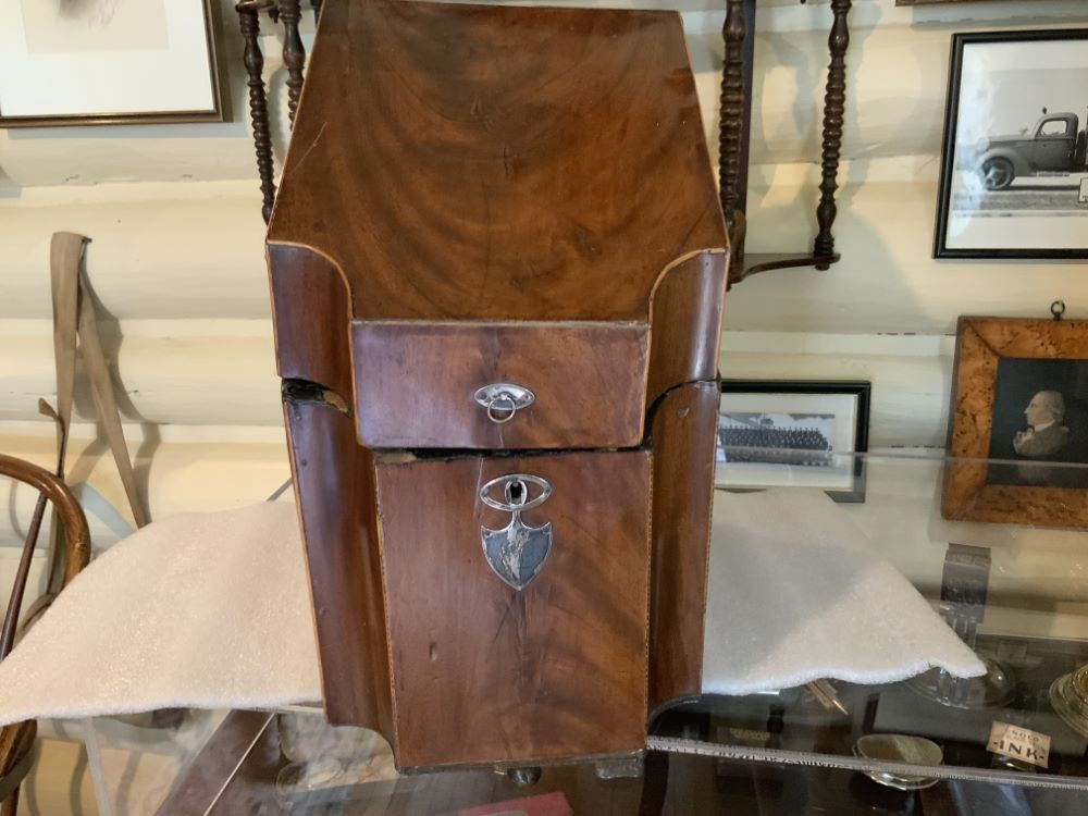
- Date
- 1750 – 1820
- Material
- wood; metal, silver; metal, brass
- Catalogue Number
- 104.20.0221
- Description
- A shaped wooden box with a hinged veneered cover. The box rests on small ball feet. The lid is bevelled to accommodate varying heights of knives. There is a keyhole at the front, near the top, of the box (key missing). A small sterling silver plaque beneath the keyhole is monogrammed “E.L.”.
1 image
- Title
- Flatware Tray
- Date
- 1750 – 1820
- Material
- wood; metal, silver; metal, brass
- Dimensions
- 22.5 x 40.4 x 29.0 cm
- Description
- A shaped wooden box with a hinged veneered cover. The box rests on small ball feet. The lid is bevelled to accommodate varying heights of knives. There is a keyhole at the front, near the top, of the box (key missing). A small sterling silver plaque beneath the keyhole is monogrammed “E.L.”.
- Subject
- households
- Credit
- Gift of Pearl Evelyn Moore, Banff, 1979
- Catalogue Number
- 104.20.0221
Images
This material is presented as originally created; it may contain outdated cultural descriptions and
potentially offensive content.
Read more.
[Gap 82 G/16 West - Alberta]
https://archives.whyte.org/en/permalink/catalogue23623
- Medium
- Library - Maps and blueprints (unannotated; published)
- Map
- Published Date
- 1944
- Publisher
- Dept. of Mines and Technical Surveys
- Call Number
- NTS
- 82G/16W
- Publisher
- Dept. of Mines and Technical Surveys
- Published Date
- 1944
- Physical Description
- Black and White
- Scale
- Scale: 1:50,000
- Relief: Contour interval 100'
- Subjects
- Gap 82 G/16 West - Alberta
- Notes
- National Topographical System
- Call Number
- NTS
- 82G/16W
- Collection
- Archives Library
This material is presented as originally created; it may contain outdated cultural descriptions and
potentially offensive content.
Read more.
[George Creek 83 C/10 East - Alta.]
https://archives.whyte.org/en/permalink/catalogue23626
- Medium
- Library - Maps and blueprints (unannotated; published)
- Map
- Published Date
- 1942
- Publisher
- Dept. of Mines and Technical Surveys
- Call Number
- NTS
- 83C/10E
- Publisher
- Dept. of Mines and Technical Surveys
- Published Date
- 1942
- Physical Description
- Black and white
- Scale
- Scale: 1:50,000
- Relief: Contour Interval 100 ft.
- Subjects
- George Creek 83 C/10 East - Alta.
- Notes
- National Topographic System
- Call Number
- NTS
- 83C/10E
- Collection
- Archives Library
This material is presented as originally created; it may contain outdated cultural descriptions and
potentially offensive content.
Read more.