Narrow Results By
[100 YR SWISS CENTENNIAL CLIMB 1999: Faye Summit notes. Bow Hut OCT - DEC 1998]
https://archives.whyte.org/en/permalink/descriptions57743
- Part Of
- Alpine Club of Canada fonds
- Scope & Content
- File consists of summit notes from Mount Fay produced by the Alpine Club of Canada between 1998 and 1999. Summit record includes entries from visitors to the various summits which pertain to individuals' hiking and climbing trips; details of specific events which occurred while at the summit, wildl…
- Date Range
- 1998-1999
- Reference Code
- M200 / V / A / 156
- Description Level
- 5 / File
- GMD
- Textual record
- Organization record
- Part Of
- Alpine Club of Canada fonds
- Description Level
- 5 / File
- Fonds Number
- M200
- V14
- S6
- Series
- M200 / V: Summit Records
- Sous-Fonds
- M200
- Sub-Series
- M200 / V / A: Identified Summit Records
- Accession Number
- accn. 2023.06
- Reference Code
- M200 / V / A / 156
- Responsibility
- Summit Registers and Notes produced by Alpine Club of Canada
- Date Range
- 1998-1999
- Physical Description
- 0.5 cm of textual records
- History / Biographical
- Mount Fay is located along the Continental/Great Divide, along the Alberta and British Columbia border. Mount Fay is part of the Canadian Rockies.
- Scope & Content
- File consists of summit notes from Mount Fay produced by the Alpine Club of Canada between 1998 and 1999. Summit record includes entries from visitors to the various summits which pertain to individuals' hiking and climbing trips; details of specific events which occurred while at the summit, wildlife sightings, trail updates, and related topics. File: M200 / V / A / 156: [100 YR SWISS CENTENNIAL CLIMB 1999: Faye Summit notes. Bow Hut OCT - DEC 1998]
- Notes
- For Bow Hut Register, see M200 / IV / F / 31
- Name Access
- Alpine Club of Canada
- Subject Access
- Alberta
- Alpine Club of Canada
- Backpacking
- British Columbia
- Climbing
- Club
- Description and travel
- Environment
- Environment and Nature
- Great Divide
- Hiking
- Mountain
- Mountaineering
- Mountaineers
- Mountains
- Record keeping
- Ski mountaineering
- Sports and leisure
- Sports and recreation
- Summit
- Trails
- Geographic Access
- Canada
- Canadian Rocky Mountains
- Great Divide
- Continental Divide
- Alberta
- British Columbia
- Mount Fay
- Access Restrictions
- Restrictions may apply
- Language
- English
- Related Material
- M235
- M200 / IV / F / 31
- Title Source
- Title based on contents of file
- Processing Status
- Processed
This material is presented as originally created; it may contain outdated cultural descriptions and
potentially offensive content.
Read more.
ACC Vancouver Office 1988-1990
https://archives.whyte.org/en/permalink/descriptions57832
- Part Of
- Alpine Club of Canada fonds
- Scope & Content
- File includes reports from the B.C. Section's Coordinator to the Board detailing work accomplished in 1988-1990.
- Date Range
- 1988-1990
- Reference Code
- M200 / I / A / 180
- Description Level
- 5 / File
- GMD
- Textual record
- Organization record
- Part Of
- Alpine Club of Canada fonds
- Description Level
- 5 / File
- Fonds Number
- M200
- V14
- S6
- Series
- M200 / I: Administrative records
- Sous-Fonds
- M200
- Sub-Series
- M200 / I / A: Club meeting minutes and reports
- Accession Number
- accn. 2023.06
- Reference Code
- M200 / I / A / 180
- Date Range
- 1988-1990
- Physical Description
- 0.5 cm of textual records
- Scope & Content
- File includes reports from the B.C. Section's Coordinator to the Board detailing work accomplished in 1988-1990.
- Notes
- Financials have been separated out into M200 / II / A / 136 ACC Vancouver Office 1988-1990 accn. 2023.06.
- Name Access
- Alpine Club of Canada
- Subject Access
- Administration
- Alpine Club of Canada
- Record keeping
- Records
- Report
- Club
- Organizations
- British Columbia
- Geographic Access
- Canada
- British Columbia
- Language
- English
- Related Material
- M200 / II / A / 136
- Title Source
- Original title
- Processing Status
- Processed
This material is presented as originally created; it may contain outdated cultural descriptions and
potentially offensive content.
Read more.
ARÊTE [ca. 1994-2016]
https://archives.whyte.org/en/permalink/descriptions57729
- Part Of
- Alpine Club of Canada fonds
- Scope & Content
- File consists of a summit record from Arête Peak produced by the Alpine Club of Canada between around 1994 and 2016. Summit record includes entries from visitors to the various summits which pertain to individuals' hiking and climbing trips; details of specific events which occurred while at the su…
- Date Range
- ca. 1994-2016
- Reference Code
- M200 / V / A / 137
- Description Level
- 5 / File
- GMD
- Textual record
- Organization record
- Part Of
- Alpine Club of Canada fonds
- Description Level
- 5 / File
- Fonds Number
- M200
- V14
- S6
- Series
- M200 / V: Summit Records
- Sous-Fonds
- M200
- Sub-Series
- M200 / V / A: Identified Summit Records
- Accession Number
- accn. 2023.20
- Reference Code
- M200 / V / A / 137
- Responsibility
- Summit Registers and Notes produced by Alpine Club of Canada
- Date Range
- ca. 1994-2016
- Physical Description
- 0.5 cm of textual record 1 volume
- History / Biographical
- Arête Peak is located in Yoho National Park, British Columbia. Nearby are Mount des Poilus and Isolated Peak.
- Scope & Content
- File consists of a summit record from Arête Peak produced by the Alpine Club of Canada between around 1994 and 2016. Summit record includes entries from visitors to the various summits which pertain to individuals' hiking and climbing trips; details of specific events which occurred while at the summit, wildlife sightings, trail updates, and related topics. File: M200 / V / A / 137: ARÊTE [ca. 1994-2016]
- Name Access
- Alpine Club of Canada
- Subject Access
- Alpine Club of Canada
- Backpacking
- British Columbia
- Climbing
- Club
- Description and travel
- Environment
- Environment and Nature
- Hiking
- Mountain
- Mountaineering
- Mountaineers
- Mountains
- National parks and reserves
- Parks Canada
- Record keeping
- Sports and leisure
- Sports and recreation
- Summit
- Trails
- Geographic Access
- Canada
- Canadian Rocky Mountains
- British Columbia
- Yoho National Park
- Access Restrictions
- Restrictions may apply
- Language
- English
- Conservation
- Register contains mold. Register has been placed in mylar.
- Related Material
- M235
- Title Source
- Title based on contents of file
- Processing Status
- Processed
This material is presented as originally created; it may contain outdated cultural descriptions and
potentially offensive content.
Read more.
British Columbia photographs compiled for a Book
https://archives.whyte.org/en/permalink/descriptions56189
- Part Of
- Douglas Leighton fonds
- Scope & Content
- File consists of photographs compiled by Douglas Leighton for a book on British Columbia. Photographs include cities, provincial parks, national parks, some locations included are Silver Star Mountain, Kaslo, Wells Gray Provinvial Park, Fort St. John, Summerland, Revelstoke, Glacier National Park, …
- Date Range
- 1981 - 1985
- 1987
- 1988
- 1990 - 1992
- 1994
- 1996
- 1999
- Reference Code
- V222 / VI / A / 1 - 2 / NS
- Description Level
- 5 / File
- GMD
- Photograph
- Transparency
- Part Of
- Douglas Leighton fonds
- Description Level
- 5 / File
- Fonds Number
- M133
- V222
- Series
- V222 / VI : Publication
- Sous-Fonds
- V222
- Sub-Series
- V222 / VI / A: Books
- Accession Number
- 2020.24
- Reference Code
- V222 / VI / A / 1 - 2 / NS
- Date Range
- 1981 - 1985
- 1987
- 1988
- 1990 - 1992
- 1994
- 1996
- 1999
- Physical Description
- 431 photographs : col. slides ; 35 mm
- Scope & Content
- File consists of photographs compiled by Douglas Leighton for a book on British Columbia. Photographs include cities, provincial parks, national parks, some locations included are Silver Star Mountain, Kaslo, Wells Gray Provinvial Park, Fort St. John, Summerland, Revelstoke, Glacier National Park, and Osoyoos.
- Name Access
- Leighton, Douglas
- Subject Access
- British Columbia
- Geographic Access
- British Columbia
- Summerland, BC
- Naramata, BC
- Vernon, BC
- Denver, BC
- Well Gray Provincial Park
- Cranbrook, BC
- Osoyoos, BC
- Language
- English
- Creator
- Douglas Leighton
- Category
- Sports, recreation and leisure
- Science and technology
- Natural resources
- Environment
- Commerce and industry
- Title Source
- Title based on contents of file
- Processing Status
- Processed
This material is presented as originally created; it may contain outdated cultural descriptions and
potentially offensive content.
Read more.
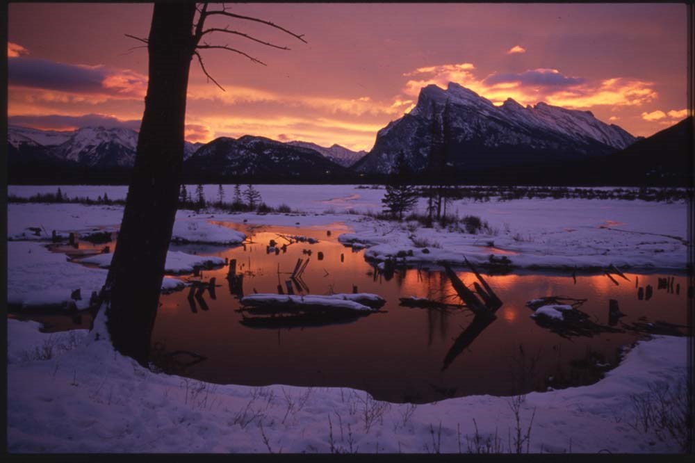
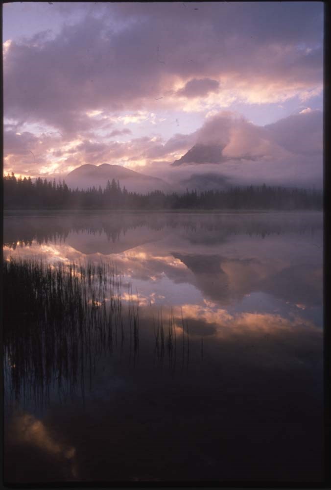
Canadian Rockies and other "active best"
https://archives.whyte.org/en/permalink/descriptions56446
- Part Of
- Douglas Leighton fonds
- Scope & Content
- File consists of photographs compiled by Douglas Leighton for publication. Includes photographs of landscapes, cityscapes, lakes, mountains, hotel, tourists, plants, waterfalls and glaciers.
- Date Range
- 1978
- 1981 - 1983
- 1987
- 1988
- 1990
- 1993 - 1995
- 1997
- 1998
- 2003
- 2006
- 2007
- Reference Code
- V222 / VI / C / 4 / NS - 1 to 119
- Description Level
- 5 / File
- GMD
- Photograph
- Transparency
4 images
- Part Of
- Douglas Leighton fonds
- Description Level
- 5 / File
- Fonds Number
- M133
- V222
- Series
- V222 / VI : Publication
- Sous-Fonds
- V222
- Sub-Series
- V222 / VI / C: Compiled for publication
- Accession Number
- 2020.24
- Reference Code
- V222 / VI / C / 4 / NS - 1 to 119
- Date Range
- 1978
- 1981 - 1983
- 1987
- 1988
- 1990
- 1993 - 1995
- 1997
- 1998
- 2003
- 2006
- 2007
- Physical Description
- 119 photographs : col. slides ; 35 mm
- Scope & Content
- File consists of photographs compiled by Douglas Leighton for publication. Includes photographs of landscapes, cityscapes, lakes, mountains, hotel, tourists, plants, waterfalls and glaciers.
- Name Access
- Leighton, Douglas
- Subject Access
- British Columbia
- Geographic Access
- Alberta
- British Columbia
- Banff National Park
- Banff
- Calgary, AB
- Edmonton, AB
- Kootenay, BC
- Yoho National Park
- Jasper National Park
- Cranbrook, BC
- Vancouver, BC
- Language
- English
- Creator
- Douglas Leighton
- Title Source
- Title based on contents of file
- Processing Status
- Processed
Images
This material is presented as originally created; it may contain outdated cultural descriptions and
potentially offensive content.
Read more.
Crown Mountain [register]
https://archives.whyte.org/en/permalink/descriptions57741
- Part Of
- Alpine Club of Canada fonds
- Scope & Content
- File consists of a summit record from Crown Mountain produced by the Alpine Club of Canada from around 1991 to 2017. Summit record includes entries from visitors to the various summits which pertain to individuals' hiking and climbing trips; details of specific events which occurred while at the su…
- Date Range
- ca. 1991-2017
- Reference Code
- M200 / V / A / 154
- Description Level
- 5 / File
- GMD
- Textual record
- Organization record
- Part Of
- Alpine Club of Canada fonds
- Description Level
- 5 / File
- Fonds Number
- M200
- V14
- S6
- Series
- M200 / V: Summit Records
- Sous-Fonds
- M200
- Sub-Series
- M200 / V / A: Identified Summit Records
- Accession Number
- accn. 2023.19
- Reference Code
- M200 / V / A / 154
- Responsibility
- Summit Registers and Notes produced by Alpine Club of Canada
- Date Range
- ca. 1991-2017
- Physical Description
- 1 volume 1 cm of textual record
- History / Biographical
- Crown Mountain is located in British Columbia near Grouse Mountain and Goat Mountain in southwestern, B.C.
- Scope & Content
- File consists of a summit record from Crown Mountain produced by the Alpine Club of Canada from around 1991 to 2017. Summit record includes entries from visitors to the various summits which pertain to individuals' hiking and climbing trips; details of specific events which occurred while at the summit, wildlife sightings, trail updates, and related topics. File: M200 / V / A / 154: Crown Mountain [register]
- Name Access
- Alpine Club of Canada
- Subject Access
- Alpine Club of Canada
- Backpacking
- British Columbia
- Climbing
- Club
- Description and travel
- Environment
- Environment and Nature
- Hiking
- Mountain
- Mountaineering
- Mountaineers
- Mountains
- Record keeping
- Sports and leisure
- Sports and recreation
- Summit
- Geographic Access
- Canada
- British Columbia
- Vancouver
- Vancouver, BC
- Access Restrictions
- Restrictions may apply
- Language
- English
- Conservation
- Register consists of loose pages. Evidence of water and rust damage throughout register.
- Related Material
- M235
- Title Source
- Title based on contents of file
- Processing Status
- Processed
This material is presented as originally created; it may contain outdated cultural descriptions and
potentially offensive content.
Read more.
Dolomite Peak July 30, 1998 - Sept. 6, 2004
https://archives.whyte.org/en/permalink/descriptions57788
- Part Of
- Alpine Club of Canada fonds
- Scope & Content
- File consists of a summit record from Dolomite Peak produced by the Alpine Club of Canada between 1998 and 2004. Summit record includes entries from visitors to the various summits which pertain to individuals' hiking and climbing trips; details of specific events which occurred while at the summit…
- Date Range
- 1998-2004
- Reference Code
- M200 / V / A / 205
- Description Level
- 5 / File
- GMD
- Textual record
- Organization record
- Part Of
- Alpine Club of Canada fonds
- Description Level
- 5 / File
- Fonds Number
- M200
- V14
- S6
- Series
- M200 / V: Summit Records
- Sous-Fonds
- M200
- Sub-Series
- M200 / V / A: Identified Summit Records
- Accession Number
- accn. 7779
- Reference Code
- M200 / V / A / 205
- Responsibility
- Summit Registers and Notes produced by Alpine Club of Canada
- Date Range
- 1998-2004
- Physical Description
- 1 volume 1 cm of textual record
- History / Biographical
- Dolomite Peak is located in the Bow Valley of Banff National Park, Alberta. It is near the Continental Divide/Great Divide, and is part of the Canadian Rockies. Nearby are Cirque Peak, Observation Peak, Peyto Lake, and Bow Lake.
- Scope & Content
- File consists of a summit record from Dolomite Peak produced by the Alpine Club of Canada between 1998 and 2004. Summit record includes entries from visitors to the various summits which pertain to individuals' hiking and climbing trips; details of specific events which occurred while at the summit, wildlife sightings, trail updates, and related topics. File: M200 / V / A / 205: Dolomite Peak July 30, 1998 - Sept. 6, 2004
- Name Access
- Alpine Club of Canada
- Subject Access
- Alberta
- Alpine Club of Canada
- Backpacking
- Banff
- Banff National Park
- Bow Valley
- British Columbia
- Climbing
- Club
- Description and travel
- Environment
- Environment and Nature
- Great Divide
- Hiking
- Mountain
- Mountaineering
- Mountaineers
- Mountains
- Record keeping
- Sports and leisure
- Sports and recreation
- Summit
- Trails
- Geographic Access
- Canada
- Canadian Rocky Mountains
- Rocky Mountains
- Continental Divide
- Great Divide
- Alberta
- British Columbia
- Banff National Park
- Bow Valley
- Peyto Lake
- Bow Lake
- Cirque Peak
- Observation Peak
- Dolomite Peak
- Access Restrictions
- Restrictions may apply
- Language
- English
- Related Material
- M235
- Title Source
- Original title
- Processing Status
- Processed
This material is presented as originally created; it may contain outdated cultural descriptions and
potentially offensive content.
Read more.
Isolated Peak Summit Records
https://archives.whyte.org/en/permalink/descriptions57690
- Part Of
- Alpine Club of Canada fonds
- Scope & Content
- Files consist of summit notes and summit registers and notes from Isolated Peak between 1996 and 2012 produced by the Alpine Club of Canada. Summit records include entries from visitors to the various summits which pertain to individuals' hiking and climbing trips; details of specific events which …
- Date Range
- 1996-2012
- Reference Code
- M200 / V / A / 83 to 84
- Description Level
- 5 / File
- GMD
- Textual record
- Organization record
- Part Of
- Alpine Club of Canada fonds
- Description Level
- 5 / File
- Fonds Number
- M200
- V14
- S6
- Series
- M200 / V: Summit Records
- Sous-Fonds
- M200
- Sub-Series
- M200 / V / A: Identified Summit Records
- Accession Number
- accn. 8002
- accn. 2023.19
- Reference Code
- M200 / V / A / 83 to 84
- Responsibility
- Summit Registers and Notes produced by Alpine Club of Canada
- Date Range
- 1996-2012
- Physical Description
- 2 volumes ca. 2 cm of textual records
- History / Biographical
- Isolated Peak is located in Little Yoho Valley of Yoho National Park, B.C. in the Canadian Rockies. Nearby are Mount McArthur, Arete Peak and Mont des Poilus, Vice President and President Mountains.
- Scope & Content
- Files consist of summit notes and summit registers and notes from Isolated Peak between 1996 and 2012 produced by the Alpine Club of Canada. Summit records include entries from visitors to the various summits which pertain to individuals' hiking and climbing trips; details of specific events which occurred while at the summit, wildlife sightings, trail updates, and related topics. Files include: M200 / V / A / 83: Summit Register - Isolated Peak, July 1996 - Aug 2009 M200 / V / A / 84: Isolated Peak [2009-2012]
- Name Access
- Alpine Club of Canada
- Subject Access
- Alpine Club of Canada
- Backpacking
- Backcountry skiing
- British Columbia
- Climbing
- Club
- Cross-country skiing
- Description and travel
- Environment
- Environment and Nature
- Hiking
- Mountain
- Mountaineering
- Mountaineers
- Mountains
- National parks and reserves
- Parks Canada
- Record keeping
- Ski area
- Ski areas
- Ski mountaineering
- Skiing
- Skiers
- Snowshoes and snowshoeing
- Sports and leisure
- Sports and recreation
- Summit
- Trails
- Winter sports
- Geographic Access
- Canada
- Canadian Rocky Mountains
- Rocky Mountains
- British Columbia
- Yoho National Park
- Little Yoho Valley
- The Vice President
- The President
- Isolated Peak
- Access Restrictions
- Restrictions may apply
- Language
- English
- French
- Conservation
- Summit notes are loose pages and contain water damage. Summit notes may contain rust damage.
- Related Material
- M235
- Biographical Source Notes
- Peak Finder, Isolated Peak, Canadian Rockies Database: https://cdnrockiesdatabases.ca/peaks/687#undefined1
- Title Source
- Title based on contents of file
- Processing Status
- Processed
This material is presented as originally created; it may contain outdated cultural descriptions and
potentially offensive content.
Read more.
Mount McArthur 1995-2001
https://archives.whyte.org/en/permalink/descriptions57789
- Part Of
- Alpine Club of Canada fonds
- Scope & Content
- File consists of a summit record from Mount McArthur produced by the Alpine Club of Canada between 1995 and 2001. Summit record includes entries from visitors to the various summits which pertain to individuals' hiking and climbing trips; details of specific events which occurred while at the summi…
- Date Range
- 1995-2001
- Reference Code
- M200 / V / A / 206
- Description Level
- 5 / File
- GMD
- Textual record
- Organization record
- Part Of
- Alpine Club of Canada fonds
- Description Level
- 5 / File
- Fonds Number
- M200
- V14
- S6
- Series
- M200 / V: Summit Records
- Sous-Fonds
- M200
- Sub-Series
- M200 / V / A: Identified Summit Records
- Accession Number
- accn. 7779
- Reference Code
- M200 / V / A / 206
- Responsibility
- Summit Registers and Notes produced by Alpine Club of Canada
- Date Range
- 1995-2001
- Physical Description
- 1 volume 0.5 cm of textual record
- History / Biographical
- Mount McArthur is located in Yoho National Park, British Columbia, near the Continental Divide/Great Divide. Nearby are Isolated Peak, Arete Peak, and Mount Carnarvon.
- Scope & Content
- File consists of a summit record from Mount McArthur produced by the Alpine Club of Canada between 1995 and 2001. Summit record includes entries from visitors to the various summits which pertain to individuals' hiking and climbing trips; details of specific events which occurred while at the summit, wildlife sightings, trail updates, and related topics. File: M200 / V / A / 206: Mount McArthur 1995-2001
- Name Access
- Alpine Club of Canada
- Subject Access
- Alpine Club of Canada
- Backpacking
- British Columbia
- Climbing
- Club
- Description and travel
- Environment
- Environment and Nature
- Great Divide
- Hiking
- Mountain
- Mountaineering
- Mountaineers
- Mountains
- National parks and reserves
- Record keeping
- Ski mountaineering
- Sports and leisure
- Sports and recreation
- Summit
- Trails
- Geographic Access
- Canada
- Canadian Rocky Mountains
- Rocky Mountains
- Continental Divide
- Great Divide
- British Columbia
- Yoho National Park
- Isolated Peak
- Arete Peak
- Mount Carnarvon
- Mount McArthur
- Access Restrictions
- Restrictions may apply
- Language
- English
- French
- Related Material
- M235
- Title Source
- Original title
- Processing Status
- Processed
This material is presented as originally created; it may contain outdated cultural descriptions and
potentially offensive content.
Read more.
Mount Niles summit register Oct. 3, 1989 - Aug. 28, 1994
https://archives.whyte.org/en/permalink/descriptions57791
- Part Of
- Alpine Club of Canada fonds
- Scope & Content
- File consists of a summit record from Mount Niles produced by the Alpine Club of Canada between 1989 and 1994. Summit record includes entries from visitors to the various summits which pertain to individuals' hiking and climbing trips; details of specific events which occurred while at the summit, …
- Date Range
- 1989-1994
- Reference Code
- M200 / V / A / 208
- Description Level
- 5 / File
- GMD
- Textual record
- Organization record
- Part Of
- Alpine Club of Canada fonds
- Description Level
- 5 / File
- Fonds Number
- M200
- V14
- S6
- Series
- M200 / V: Summit Records
- Sous-Fonds
- M200
- Sub-Series
- M200 / V / A: Identified Summit Records
- Accession Number
- accn. 2023.10
- Reference Code
- M200 / V / A / 208
- Responsibility
- Summit Registers and Notes produced by Alpine Club of Canada
- Date Range
- 1989-1994
- Physical Description
- 1 volume 1 cm of textual record
- History / Biographical
- Mount Niles is part of the Canadian Rockies in Yoho National Park, British Columbia. Nearby are the Continental Divide/Great Divide, Mount Ogden, Waptutik Icefield, Mount Balfour, and Mount Yukness.
- Scope & Content
- File consists of a summit record from Mount Niles produced by the Alpine Club of Canada between 1989 and 1994. Summit record includes entries from visitors to the various summits which pertain to individuals' hiking and climbing trips; details of specific events which occurred while at the summit, wildlife sightings, trail updates, and related topics. File: M200 / V / A / 208: Mount Niles summit register Oct. 3, 1989 - Aug. 28, 1994
- Name Access
- Alpine Club of Canada
- Subject Access
- Alpine Club of Canada
- Backpacking
- British Columbia
- Climbing
- Club
- Description and travel
- Environment
- Environment and Nature
- Great Divide
- Hiking
- Mountain
- Mountaineering
- Mountaineers
- Mountains
- National parks and reserves
- Record keeping
- Ski area
- Ski areas
- Ski mountaineering
- Sports and leisure
- Sports and recreation
- Summit
- Trails
- Geographic Access
- Canada
- Canadian Rocky Mountains
- Rocky Mountains
- Continental Divide
- Great Divide
- British Columbia
- Yoho National Park
- Waputik Icefield
- Mount Yukness
- Mount Balfour
- Mount Ogden
- Mount Niles
- Access Restrictions
- Restrictions may apply
- Reproduction Restrictions
- Register in poor condition due to mold.
- Language
- English
- Conservation
- Register placed in mylar due to presence of mold. Register is loose pages, as staples holding the binding together have rusted and corroded.
- Related Material
- M235
- Biographical Source Notes
- Peak Finder: Mount Niles, Canadian Rockies Database: https://cdnrockiesdatabases.ca/peaks/966
- Title Source
- Original title
- Processing Status
- Processed
This material is presented as originally created; it may contain outdated cultural descriptions and
potentially offensive content.
Read more.
Mount Sir Donald Summit Records
https://archives.whyte.org/en/permalink/descriptions57694
- Part Of
- Alpine Club of Canada fonds
- Scope & Content
- Files consist of summit notes and summit registers from Mount Sir Donald produced by the Alpine Club of Canada between 1984 and around 2013. Summit records include entries from visitors to the various summits which pertain to individuals' hiking and climbing trips; details of specific events which …
- Date Range
- 1984-1989
- 2003-ca. 2013
- Reference Code
- M200 / V / A / 97 to 100
- Description Level
- 5 / File
- GMD
- Textual record
- Organization record
- Part Of
- Alpine Club of Canada fonds
- Description Level
- 5 / File
- Fonds Number
- M200
- V14
- S6
- Series
- M200 / V: Summit Records
- Sous-Fonds
- M200
- Sub-Series
- M200 / V / A: Identified Summit Records
- Accession Number
- accn. 5680
- accn. 2014.8347
- Reference Code
- M200 / V / A / 97 to 100
- Responsibility
- Summit Registers and Notes produced by Alpine Club of Canada
- Date Range
- 1984-1989
- 2003-ca. 2013
- Physical Description
- 4 volumes 4 cm of textual records
- History / Biographical
- Mount Sir Donald is located in the Rogers Pass area of Glacier National Park, in the Selkirk Mountains of B. C. The mountain was originally named Syndicate Peak, but it was officially named after Sir Donald A. Smith, the first Baron Strathcona and Mount Royal, who was the head of the syndicate; he was also the Canadian Pacific Railway director who drove in the Last Spike on the CPR at Craigellachie in 1885.
- Scope & Content
- Files consist of summit notes and summit registers from Mount Sir Donald produced by the Alpine Club of Canada between 1984 and around 2013. Summit records include entries from visitors to the various summits which pertain to individuals' hiking and climbing trips; details of specific events which occurred while at the summit, wildlife sightings, trail updates, and related topics. Files include: M200 / V / A / 97: [Mt. Sir Donald register 1984-1989] M200 / V / A / 98: MT. SIR DONALD Summit Log 2003 - 2009 M200 / V / A / 99: Mt. Sir Donald, Sept 2, 2009 M200 / V / A / 100: Mt. Sir Donald 3284m Summit Register [2010 - ca. 2013]
- Name Access
- Alpine Club of Canada
- Subject Access
- Alpine Club of Canada
- Backcountry skiing
- Backpacking
- British Columbia
- Canadian Pacific Railway
- Climbing
- Club
- Cross-country skiing
- Description and travel
- Environment
- Environment and Nature
- Hiking
- Mountain
- Mountaineering
- Mountaineers
- Mountains
- National parks and reserves
- Parks
- Parks Canada
- Record keeping
- Ski area
- Ski areas
- Ski mountaineering
- Skiing
- Sports and leisure
- Sports and recreation
- Summit
- Trails
- Winter sports
- Geographic Access
- Canada
- British Columbia
- Rocky Mountains
- Canadian Rocky Mountains
- Rogers Pass
- Selkirks
- Glacier National Park
- Uto Peak
- Terminal Peak
- Mount Macdonald
- Mount Sir Donald
- Access Restrictions
- Restrictions may apply
- Language
- English
- Conservation
- Some registers have water damage. Some registers loose pages.
- Related Material
- M235
- Biographical Source Notes
- Parks Canada, Day Hikes: Mount Sir Donald: https://parks.canada.ca/pn-np/bc/glacier/activ/randonee-hiking/journee-day
- Title Source
- Title based on contents of file
- Processing Status
- Processed
This material is presented as originally created; it may contain outdated cultural descriptions and
potentially offensive content.
Read more.
[Mount Spring Rice and Mount Leval]
https://archives.whyte.org/en/permalink/descriptions57742
- Part Of
- Alpine Club of Canada fonds
- Scope & Content
- File consists of summit records from Mount Spring-Rice and Mount Leval, produced by the Alpine Club of Canada around 1972 and 1994. Summit records include entries from visitors to the various summits which pertain to individuals' hiking and climbing trips; details of specific events which occurred …
- Date Range
- ca. 1972-1994
- Reference Code
- M200 / V / A / 155
- Description Level
- 5 / File
- GMD
- Textual record
- Organization record
- Part Of
- Alpine Club of Canada fonds
- Description Level
- 5 / File
- Fonds Number
- M200
- V14
- S6
- Series
- M200 / V: Summit Records
- Sous-Fonds
- M200
- Sub-Series
- M200 / V / A: Identified Summit Records
- Accession Number
- accn. 2014.8275
- Reference Code
- M200 / V / A / 155
- Responsibility
- Summit Registers and Notes produced by Alpine Club of Canada
- Date Range
- ca. 1972-1994
- Physical Description
- 2 volumes 1 cm of textual records
- History / Biographical
- Mount Spring Rice and Mount Leval are both located along the Continental/Great Divide and are both part of the Canadian Rockies.
- Scope & Content
- File consists of summit records from Mount Spring-Rice and Mount Leval, produced by the Alpine Club of Canada around 1972 and 1994. Summit records include entries from visitors to the various summits which pertain to individuals' hiking and climbing trips; details of specific events which occurred while at the summit, wildlife sightings, trail updates, and related topics. File: M200 / V / A / 155: [Mount Spring Rice and Mount Leval]
- Notes
- Mount Spring Rice summit notes are loose in a plastic bag. Notes contain heavy water damage. Caution: Evidence of black mold throughout summit notes. Mount Leval summit note placed in mylar.
- Name Access
- Alpine Club of Canada
- Subject Access
- Alberta
- Alpine Club of Canada
- Backpacking
- British Columbia
- Club
- Climbing
- Description and travel
- Environment
- Environment and Nature
- Great Divide
- Mountain
- Mountaineering
- Mountaineers
- Mountains
- Record keeping
- Sports and leisure
- Sports and recreation
- Summit
- Geographic Access
- Canada
- Canadian Rocky Mountains
- Rocky Mountains
- Great Divide
- Continental Divide
- Alberta
- British Columbia
- Access Restrictions
- Restrictions may apply
- Language
- English
- Conservation
- Mount Spring Rice summit notes are loose in a plastic bag. Notes contain heavy water damage. Caution: Black mold is present throughout summit notes. Mount Leval summit note placed in mylar.
- Related Material
- M235
- Title Source
- Title based on contents of file
- Processing Status
- Processed
This material is presented as originally created; it may contain outdated cultural descriptions and
potentially offensive content.
Read more.
Mount Victoria Summit Record
https://archives.whyte.org/en/permalink/descriptions57688
- Part Of
- Alpine Club of Canada fonds
- Scope & Content
- File consists of one summit register from Mount Victoria produced by the Alpine Club of Canada between 1998 and 2004. Summit record include entries from visitors to the various summits which pertain to individuals' hiking and climbing trips; details of specific events which occurred while at the su…
- Date Range
- September 1998 - August 2004
- Reference Code
- M200 / V / A / 81
- Description Level
- 5 / File
- GMD
- Textual record
- Organization record
- Part Of
- Alpine Club of Canada fonds
- Description Level
- 5 / File
- Fonds Number
- M200
- V14
- S6
- Series
- M200 / V: Summit Records
- Sous-Fonds
- M200
- Sub-Series
- M200 / V / A: Identified Summit Records
- Accession Number
- accn. 8002
- Reference Code
- M200 / V / A / 81
- Responsibility
- Summit Registers and Notes produced by Alpine Club of Canada
- Date Range
- September 1998 - August 2004
- Physical Description
- 1 cm of textual records 1 volume
- History / Biographical
- Mount Victoria is located in both Yoho National Park, B. C. and Banff National Park, AB in the Canadian Rockies. The mountain is part of the mountain range along the Continental Divide, between Alberta and B.C. Nearby are Lake O'Hara, Lake Louise, Abbot Pass and Mount Lefroy. Mount Victoria was named for Queen Victoria.
- Scope & Content
- File consists of one summit register from Mount Victoria produced by the Alpine Club of Canada between 1998 and 2004. Summit record include entries from visitors to the various summits which pertain to individuals' hiking and climbing trips; details of specific events which occurred while at the summit, wildlife sightings, trail updates, and related topics. File: M200 / V / A / 81: Summit - MT. Victoria, Sept. 1998 - Aug. 2004
- Name Access
- Alpine Club of Canada
- Subject Access
- Alberta
- Abbot Pass
- Alpine Club of Canada
- Backcountry skiing
- Backpacking
- Banff National Park
- Bow Valley
- British Columbia
- Climbing
- Club
- Cross-country skiing
- Description and travel
- Environment
- Environment and Nature
- Hiking
- Lake Louise
- Lake O'hara
- Mountain
- Mountaineering
- Mountaineers
- Mountains
- Parks Canada
- Record keeping
- Ski area
- Ski areas
- Ski mountaineering
- Ski touring
- Skiers
- Skiing
- Snowshoes and snowshoeing
- Sports and leisure
- Sports and recreation
- Summit
- Trails
- Winter sports
- Geographic Access
- Canada
- Alberta
- British Columbia
- Banff National Park
- Yoho National Park
- Lake O'Hara
- Lake Louise
- Lake Louise, AB
- Abbot Pass
- Abbott Pass
- Mount Lefroy
- Mount Victoria
- Access Restrictions
- Restrictions may apply
- Language
- English
- French
- German
- Japanese
- Related Material
- M235
- Biographical Source Notes
- Peak Finder: Mount Victoria, Canadian Rockies Database: https://cdnrockiesdatabases.ca/peaks/1459
- Title Source
- Title based on contents of file
- Processing Status
- Processed
This material is presented as originally created; it may contain outdated cultural descriptions and
potentially offensive content.
Read more.
Mt. Assiniboine Summit Records
https://archives.whyte.org/en/permalink/descriptions57697
- Part Of
- Alpine Club of Canada fonds
- Scope & Content
- Files consist of summit notes and summit registers from Mount Assiniboine produced by the Alpine Club of Canada between 1977 and 1998. Summit records include entries from visitors to the various summits which pertain to individuals' hiking and climbing trips; details of specific events which occurr…
- Date Range
- 1977-1998
- Reference Code
- M200 / V / A / 107 to 108
- Description Level
- 5 / File
- GMD
- Textual record
- Organization record
- Part Of
- Alpine Club of Canada fonds
- Description Level
- 5 / File
- Fonds Number
- M200
- V14
- S6
- Series
- M200 / V: Summit Records
- Sous-Fonds
- M200
- Sub-Series
- M200 / V / A: Identified Summit Records
- Accession Number
- accn. 5396
- accn. 7779
- Reference Code
- M200 / V / A / 107 to 108
- Responsibility
- Summit Registers and Notes produced by Alpine Club of Canada
- Date Range
- 1977-1998
- Physical Description
- 2 volumes 2 cm of textual records
- History / Biographical
- Mount Assiniboine is located along the Continental Divide, in the Rocky Mountains, in British Columbia. It was named in 1885, and it sits on the border of Mount Assiniboine Provincial Park, B. C. and Banff National Park, AB. In 1925, Lawrence Grassi became the first person to make a solo attempt of the mountain. Mount Assiniboine was first climbed in 1901 by James Outram, Christian Bohren and Christian Hasler.
- Scope & Content
- Files consist of summit notes and summit registers from Mount Assiniboine produced by the Alpine Club of Canada between 1977 and 1998. Summit records include entries from visitors to the various summits which pertain to individuals' hiking and climbing trips; details of specific events which occurred while at the summit, wildlife sightings, trail updates, and related topics. Files include: M200 / V / A / 107: [Mt. Assiniboine log book 1977-1987] M200 / V / A / 108: [Mt. Assiniboine Aug. 1978 - Aug. 1998]
- Notes
- File M200 / V / A / 108: [Mt. Assiniboine Aug. 1978 - Aug. 1998] contains a piece of engraved metal.
- Name Access
- Alpine Club of Canada
- Subject Access
- Alpine Club of Canada
- Backcountry skiing
- Backpacking
- Alberta
- Banff National Park
- Banff
- Bow Valley
- British Columbia
- Climbing
- Club
- Cross-country skiing
- Description and travel
- Environment
- Environment and Nature
- Hiking
- Mount Assiniboine
- Mountain
- Mountaineering
- Mountaineers
- Mountains
- National parks and reserves
- Parks Canada
- Parks
- Provincial parks and reserves
- Record keeping
- Ski area
- Ski areas
- Ski mountaineering
- Skiing
- Skis
- Sports and leisure
- Sports and recreation
- Summit
- Trails
- Winter sports
- Geographic Access
- Canada
- Canadian Rocky Mountains
- Rocky Mountains
- Continental Divide
- Alberta
- British Columbia
- Banff National Park
- Assiniboine Provincial Park
- Mount Assiniboine Park
- Bow Valley
- Mount Assiniboine
- Access Restrictions
- Restrictions may apply
- Reproduction Restrictions
- Contains personal information
- Language
- English
- Conservation
- Some materials have been placed in mylar. Some materials have water damage. File M200 / V / A / 108: [Mt. Assiniboine Aug. 1978 - Aug. 1998] contains a piece of engraved metal that has been placed in a conservation bag within the file.
- Related Material
- M235
- Biographical Source Notes
- Peak Finder: Mount Assiniboine, Canadian Rockies Database: https://cdnrockiesdatabases.ca/peaks/57#undefined1
- Title Source
- Title based on contents of file
- Processing Status
- Processed
This material is presented as originally created; it may contain outdated cultural descriptions and
potentially offensive content.
Read more.
Mt. Carnarvon Summit Records
https://archives.whyte.org/en/permalink/descriptions57760
- Part Of
- Alpine Club of Canada fonds
- Scope & Content
- Files consist of summit records from Mount Carnarvon produced by the Alpine Club of Canada between 1990 and 2010. Summit record includes entries from visitors to the various summits which pertain to individuals' hiking and climbing trips; details of specific events which occurred while at the summi…
- Date Range
- 1990-2010
- Reference Code
- M200 / V / A / 203 to 204
- Description Level
- 5 / File
- GMD
- Textual record
- Organization record
- Part Of
- Alpine Club of Canada fonds
- Description Level
- 5 / File
- Fonds Number
- M200
- V14
- S6
- Series
- M200 / V: Summit Records
- Sous-Fonds
- M200
- Sub-Series
- M200 / V / A: Identified Summit Records
- Accession Number
- accn. 2014.8315
- accn. 7779
- Reference Code
- M200 / V / A / 203 to 204
- Responsibility
- Summit Registers and Notes produced by Alpine Club of Canada
- Date Range
- 1990-2010
- Physical Description
- 2 volume 2 cm of textual record
- History / Biographical
- Mount Carnarvon is located in Kiwetinok River Valley of Yoho National Park, British Columbia. It is part of the President Range of the Canadian Rocky Mountains.
- Scope & Content
- Files consist of summit records from Mount Carnarvon produced by the Alpine Club of Canada between 1990 and 2010. Summit record includes entries from visitors to the various summits which pertain to individuals' hiking and climbing trips; details of specific events which occurred while at the summit, wildlife sightings, trail updates, and related topics. File: M200 / V / A / 203: Mt. Carnarvon Jul 14, 1990 - Jul 20, 1997 M200 / V / A / 204: Mt. Carnarvon Log Book [1997-2010]
- Name Access
- Alpine Club of Canada
- Subject Access
- Alpine Club of Canada
- Backpacking
- Backcountry skiing
- British Columbia
- Club
- Climbing
- Description and travel
- Environment
- Environment and Nature
- Hiking
- Mountain
- Mountaineering
- Mountaineers
- Mountains
- National parks and reserves
- Record keeping
- Sports and leisure
- Sports and recreation
- Summit
- Trails
- Geographic Access
- Canada
- Canadian Rocky Mountains
- Rocky Mountains
- President Range
- British Columbia
- Yoho National Park
- Kiwetinok River Valley
- Isolated Peak
- Emerald Lake
- Mount Carnarvon
- Access Restrictions
- Restrictions may apply
- Language
- English
- French
- Spanish
- Related Material
- M235
- Biographical Source Notes
- Peak Finder: Mount Carnarvon, Canadian Rockies Database: https://cdnrockiesdatabases.ca/peaks/216
- Title Source
- Title based on contents of file
- Processing Status
- Processed
This material is presented as originally created; it may contain outdated cultural descriptions and
potentially offensive content.
Read more.
- Part Of
- Alpine Club of Canada fonds
- Scope & Content
- File consist of summit notes and summit registers from Mount Douglas produced by the Alpine Club of Canada between approximately 1988 and 2016. Summit records include entries from visitors to the various summits which pertain to individuals' hiking and climbing trips; details of specific events whi…
- Date Range
- ca. 1988-2016
- Reference Code
- M200 / V / A / 166
- Description Level
- 5 / File
- GMD
- Textual record
- Organization record
- Part Of
- Alpine Club of Canada fonds
- Description Level
- 5 / File
- Fonds Number
- M200
- V14
- S6
- Series
- M200 / V: Summit Records
- Sous-Fonds
- M200
- Sub-Series
- M200 / V / A: Identified Summit Records
- Accession Number
- accn. 2023.20
- Reference Code
- M200 / V / A / 166
- Responsibility
- Summit Registers and Notes produced by Alpine Club of Canada
- Date Range
- ca. 1988-2016
- Physical Description
- 2 cm of textual records 3 volumes
- History / Biographical
- Mount Douglas is located in the Greater Victoria area of British Columbia.
- Scope & Content
- File consist of summit notes and summit registers from Mount Douglas produced by the Alpine Club of Canada between approximately 1988 and 2016. Summit records include entries from visitors to the various summits which pertain to individuals' hiking and climbing trips; details of specific events which occurred while at the summit, wildlife sightings, trail updates, and related topics. File: M200 / V / A / 166: Mt. Douglas
- Notes
- File contains a summit register from Kiwetinok Peak.
- Name Access
- Alpine Club of Canada
- Subject Access
- Alpine Club of Canada
- Backpacking
- British Columbia
- Climbing
- Club
- Description and travel
- Environment
- Environment and Nature
- Hiking
- Mountain
- Mountaineering
- Mountaineers
- Mountains
- Record keeping
- Sports and leisure
- Sports and recreation
- Summit
- Trails
- Geographic Access
- Canada
- British Columbia
- Victoria
- Victoria, BC
- Victoria, British Columbia
- Saanich, B.C.
- Mount Douglas
- Mount Doug
- Access Restrictions
- Restrictions may apply
- Language
- English
- Conservation
- Some registers have rust damage. Some registers placed in mylar due to severe mold. Registers have water damage.
- Related Material
- M235
- Title Source
- Original title
- Processing Status
- Processed
This material is presented as originally created; it may contain outdated cultural descriptions and
potentially offensive content.
Read more.
[Mt. Field, 1994-2000]
https://archives.whyte.org/en/permalink/descriptions57708
- Part Of
- Alpine Club of Canada fonds
- Scope & Content
- File consists of a summit record from Mount Field produced by the Alpine Club of Canada between 1994 and 2000. Summit record includes entries from visitors to the various summits which pertain to individuals' hiking and climbing trips; details of specific events which occurred while at the summit, …
- Date Range
- 1994-2000
- Reference Code
- M200 / V / A / 118
- Description Level
- 5 / File
- GMD
- Textual record
- Organization record
- Part Of
- Alpine Club of Canada fonds
- Description Level
- 5 / File
- Fonds Number
- M200
- V14
- S6
- Series
- M200 / V: Summit Records
- Sous-Fonds
- M200
- Sub-Series
- M200 / V / A: Identified Summit Records
- Accession Number
- accn. 2023.10
- Reference Code
- M200 / V / A / 118
- Responsibility
- Summit Registers and Notes produced by Alpine Club of Canada
- Date Range
- 1994-2000
- Physical Description
- 1 volume 0.5 cm of textual record
- History / Biographical
- Mt. Field is located in the Canadian Rockies, in Yoho National Park near the town of Field, B.C. Nearby are Mount Burgess, Wapta Mountain, and Emerald Lake.
- Scope & Content
- File consists of a summit record from Mount Field produced by the Alpine Club of Canada between 1994 and 2000. Summit record includes entries from visitors to the various summits which pertain to individuals' hiking and climbing trips; details of specific events which occurred while at the summit, wildlife sightings, trail updates, and related topics. File: M200 / V / A / 118: [Mt. Field, 1994-2000]
- Name Access
- Alpine Club of Canada
- Subject Access
- Alpine Club of Canada
- Backcountry skiing
- Backpacking
- British Columbia
- Climbing
- Club
- Cross-country skiing
- Description and travel
- Environment
- Environment and Nature
- Hiking
- Mountain
- Mountaineering
- Mountaineers
- Mountains
- National parks and reserves
- Record keeping
- Ski areas
- Ski area
- Ski mountaineering
- Skiers
- Skiing
- Skis
- Sports and leisure
- Sports and recreation
- Summit
- Trails
- Winter sports
- Geographic Access
- Canada
- Canadian Rocky Mountains
- British Columbia
- Yoho National Park
- Field
- Mount Burgess
- Wapta Mountain
- Emerald Lake
- Mount Field, B.C.
- Access Restrictions
- Restrictions may apply
- Language
- English
- Related Material
- M235
- Title Source
- Title based on contents of file
- Processing Status
- Processed
This material is presented as originally created; it may contain outdated cultural descriptions and
potentially offensive content.
Read more.
Mt. Lefroy Summit Records
https://archives.whyte.org/en/permalink/descriptions57737
- Part Of
- Alpine Club of Canada fonds
- Scope & Content
- Files consist of summit notes and summit registers Mount Lefroy produced by the Alpine Club of Canada between 1985 and 2010. Summit records include entries from visitors to the various summits which pertain to individuals' hiking and climbing trips; details of specific events which occurred while a…
- Date Range
- 1985-2010
- Reference Code
- M200 / V / A / 148 to 149
- Description Level
- 5 / File
- GMD
- Textual record
- Organization record
- Part Of
- Alpine Club of Canada fonds
- Description Level
- 5 / File
- Fonds Number
- M200
- V14
- S6
- Series
- M200 / V: Summit Records
- Sous-Fonds
- M200
- Sub-Series
- M200 / V / A: Identified Summit Records
- Accession Number
- accn. 5631
- accn. 2023.19
- Reference Code
- M200 / V / A / 148 to 149
- Responsibility
- Summit Registers and Notes produced by Alpine Club of Canada
- Date Range
- 1985-2010
- Physical Description
- 2 volumes 3 cm of textual records
- History / Biographical
- Mount Lefroy is located in along the Continental/Great Divide, and is part of the Canadian Rocky Mountains. Nearby are Abbot Pass and Mount Victoria. Mount Lefroy is the site of the first fatal mountaineering accident in Canada.
- Scope & Content
- Files consist of summit notes and summit registers Mount Lefroy produced by the Alpine Club of Canada between 1985 and 2010. Summit records include entries from visitors to the various summits which pertain to individuals' hiking and climbing trips; details of specific events which occurred while at the summit, wildlife sightings, trail updates, and related topics. Files include: M200 / V / A / 148: [Mt. Lefroy register 1985-1987] M200 / V / A / 149: Mt. Lefroy. [ca. 1986-2010]
- Name Access
- Alpine Club of Canada
- Subject Access
- Alberta
- Alpine Club of Canada
- Backcountry skiing
- Backpacking
- Banff
- Banff National Park
- British Columbia
- Climbing
- Club
- Description and travel
- Environment
- Environment and Nature
- Great Divide
- Hiking
- Mountain
- Mountaineering
- Mountaineers
- Mountains
- National parks and reserves
- Provincial parks and reserves
- Record keeping
- Ski mountaineering
- Skiing
- Skiers
- Skis
- Sports and leisure
- Sports and recreation
- Summit
- Trails
- Geographic Access
- Canada
- Canadian Rocky Mountains
- Rocky Mountains
- Continental Divide
- Great Divide
- Alberta
- British Columbia
- Banff National Park
- Yoho National Park
- Abbott Pass
- Abbot Pass
- Mount Victoria
- Mount Lefroy
- Access Restrictions
- Restrictions may apply
- Language
- English
- Japanese
- French
- Conservation
- Register has evidence of rust damage and loose pages. Pages have tears and some water damage.
- Related Material
- M235
- Title Source
- Title based on contents of file
- Processing Status
- Processed
This material is presented as originally created; it may contain outdated cultural descriptions and
potentially offensive content.
Read more.
Mt. McPhail Summit Register
https://archives.whyte.org/en/permalink/descriptions57711
- Part Of
- Alpine Club of Canada fonds
- Scope & Content
- File consists of a summit record from Mount McPhail produced by the Alpine Club of Canada around 1994. Summit record includes entries from visitors to the various summits which pertain to individuals' hiking and climbing trips; details of specific events which occurred while at the summit, wildlife…
- Date Range
- ca. 1994
- Reference Code
- M200 / V / A / 121
- Description Level
- 5 / File
- GMD
- Textual record
- Organization record
- Part Of
- Alpine Club of Canada fonds
- Description Level
- 5 / File
- Fonds Number
- M200
- V14
- S6
- Series
- M200 / V: Summit Records
- Sous-Fonds
- M200
- Sub-Series
- M200 / V / A: Identified Summit Records
- Accession Number
- accn. 2014.8293
- Reference Code
- M200 / V / A / 121
- Responsibility
- Summit Registers and Notes produced by Alpine Club of Canada
- Date Range
- ca. 1994
- Physical Description
- 1 volume 1 cm of textual record
- History / Biographical
- Mount McPhail is located in the Elk Range of the Park Ranges of the Canadian Rockies and is along the Continental Divide, between the Alberta and British Columbia border. It is within the Kananaskis Country Provincial Park boundary, Mount McPhail is also known as "The Pyramid" for its shape. The mountain was named for Corporal Norman RR. McPhail, a member of the Surveyor General staff, who fought and was killed in action in WWI.
- Scope & Content
- File consists of a summit record from Mount McPhail produced by the Alpine Club of Canada around 1994. Summit record includes entries from visitors to the various summits which pertain to individuals' hiking and climbing trips; details of specific events which occurred while at the summit, wildlife sightings, trail updates, and related topics. File: M200 / V / A / 121: Mt. McPhail Summit Register
- Name Access
- Alpine Club of Canada
- Subject Access
- Alberta
- Alpine Club of Canada
- Backcountry skiing
- Backpacking
- Banff
- Banff National Park
- Bow Valley
- British Columbia
- Climbing
- Club
- Cross-country skiing
- Description and travel
- Environment
- Environment and Nature
- Hiking
- Kananaskis Country
- Mountain
- Mountaineering
- Mountaineers
- Mountains
- National parks and reserves
- Provincial parks and reserves
- Record keeping
- Ski area
- Ski areas
- Ski mountaineering
- Skiing
- Skiers
- Sports and leisure
- Sports and recreation
- Summit
- Winter sports
- Geographic Access
- Canada
- Canadian Rocky Mountains
- Alberta
- British Columbia
- Banff National Park
- Yoho National Park
- Continental Divide
- Elk Range Mountains
- Mount McPhail
- Access Restrictions
- Restrictions may apply
- Language
- English
- Conservation
- Register contains black mold, water damage. Register is placed in mylar.
- Related Material
- M235
- Biographical Source Notes
- Peak Finder: Mount McPhail, Canadian Rockies Database: https://cdnrockiesdatabases.ca/peaks/889
- Title Source
- Original title used
- Processing Status
- Processed
This material is presented as originally created; it may contain outdated cultural descriptions and
potentially offensive content.
Read more.
Mt. Rhondda Summit Records
https://archives.whyte.org/en/permalink/descriptions57783
- Part Of
- Alpine Club of Canada fonds
- Scope & Content
- Files consist of summit notes and summit registers from Mount Rhondda produced by the Alpine Club of Canada between 1988 and 1998. Summit records include entries from visitors to the various summits which pertain to individuals' hiking and climbing trips; details of specific events which occurred w…
- Date Range
- 1988-1998
- Reference Code
- M200 / V / A / 197 to 198
- Description Level
- 5 / File
- GMD
- Textual record
- Organization record
- Part Of
- Alpine Club of Canada fonds
- Description Level
- 5 / File
- Fonds Number
- M200
- V14
- S6
- Series
- M200 / V: Summit Records
- Sous-Fonds
- M200
- Sub-Series
- M200 / V / A: Identified Summit Records
- Accession Number
- accn. 6396
- accn. 7779
- Reference Code
- M200 / V / A / 197 to 198
- Responsibility
- Summit Registers and Notes produced by Alpine Club of Canada
- Date Range
- 1988-1998
- Physical Description
- 2 volumes 2 cm of textual records
- History / Biographical
- Mount Rhondda is located along the Continental Divide/Great Divide, along the Canadian Rockies. It is in the centre of the Wapta Icefield. It also lies along the border of Banff National Park, Alberta and Yoho National Park, British Columbia.
- Scope & Content
- Files consist of summit notes and summit registers from Mount Rhondda produced by the Alpine Club of Canada between 1988 and 1998. Summit records include entries from visitors to the various summits which pertain to individuals' hiking and climbing trips; details of specific events which occurred while at the summit, wildlife sightings, trail updates, and related topics. Files include: M200 / V / A / 197: [Mt. Rhondda South register, 1988-1991] M200 / V / A / 198: [Mt. Rhondda summit register March 11, 1988 - July 6, 1998]
- Name Access
- Alpine Club of Canada
- Subject Access
- Alberta
- Alpine Club of Canada
- Banff
- Banff National Park
- Bow Valley
- British Columbia
- Climbing
- Club
- Description and travel
- Environment
- Environment and Nature
- Great Divide
- Hiking
- Mountain
- Mountaineering
- Mountaineers
- Mountains
- National parks and reserves
- Record keeping
- Sports and leisure
- Sports and recreation
- Summit
- Trails
- Geographic Access
- Canada
- Canadian Rocky Mountains
- Rocky Mountains
- Great Divide
- Continental Divide
- Alberta
- British Columbia
- Banff National Park
- Yoho National Park
- Wapta Icefield
- Mont des Pollus
- Arete Peak
- Mount Gordon
- Mount Rhondda
- Access Restrictions
- Restrictions may apply
- Reproduction Restrictions
- Both registers contain black mold
- Language
- English
- Conservation
- Both registers have been placed in mylar due to black mold.
- Related Material
- M235
- Biographical Source Notes
- Peak Finder: Mount Rhondda, Canadian Rockies Database: https://cdnrockiesdatabases.ca/peaks/1164
- Title Source
- Title based on contents of file
- Processing Status
- Processed
This material is presented as originally created; it may contain outdated cultural descriptions and
potentially offensive content.
Read more.