Narrow Results By
Canada's first nations : a history of founding peoples from earliest times
https://archives.whyte.org/en/permalink/catalogue1467
- Medium
- Library - Book (including soft-cover and pamphlets)
- Published Date
- 1992
- Author
- Dickason, Olive Patricia
- Publisher
- Don Mills, Ont. : Oxford University Press
- Call Number
- 07.2 D55c
- Author
- Dickason, Olive Patricia
- Responsibility
- Olive Patricia Dickason
- Publisher
- Don Mills, Ont. : Oxford University Press
- Published Date
- 1992
- Subjects
- First Nations
- History
- Canada
- Abstract
- Designed to provide a comprehensive introduction into the subject. Interdisciplinary approach, incorporating insighes from archaology, anthropology, biology, sociology, and political science, adds depth as well as breadth.
- Contents
- At the beginning -- The outside world intrudes -- Spread across the continent -- Towards new horizons -- Into the contemporary world
- ISBN
- 0-7710-2800-8 pbk
- Accession Number
- 2019.01
- Call Number
- 07.2 D55c
- Collection
- Archives Library
This material is presented as originally created; it may contain outdated cultural descriptions and
potentially offensive content.
Read more.
Canadian Pacific Railway chart of Nepigon Bay Lake Superior
https://archives.whyte.org/en/permalink/catalogue21434
- Medium
- Library - Maps and blueprints (unannotated; published)
- Map
- Published Date
- January 1874
- Call Number
- C11-3.7(d)
- Responsibility
- Surveyed by Admiral Bayfield R.N.
- Published Date
- January 1874
- Subjects
- Canada
- Railway routes
- Notes
- To accompany: "Report of the Enginer in Chief Canadian Pacific Railway" 08.5/C16/
- Accession Number
- 10,000
- Call Number
- C11-3.7(d)
- Collection
- Archives Library
This material is presented as originally created; it may contain outdated cultural descriptions and
potentially offensive content.
Read more.
Canadian Pacific Railway chart of the Thunder Bay-Lake Superior
https://archives.whyte.org/en/permalink/catalogue24556
- Medium
- Library - Maps and blueprints (unannotated; published)
- Map
- Published Date
- January 1874
- Call Number
- C11-3.7(c)
- Responsibility
- Surveyed by Admiral Bayfield R.N.
- Published Date
- January 1874
- Scale
- Soundings are in feet
- Subjects
- Canada
- Railway routes
- Notes
- To accompany report of the Engineer in Chief, C.P.R. 08.5/C16/rep
- Accession Number
- 10,000
- Call Number
- C11-3.7(c)
- Collection
- Archives Library
This material is presented as originally created; it may contain outdated cultural descriptions and
potentially offensive content.
Read more.
Canadian Pacific Railway sketch plan of the mouth of the Saskatchewan River from Hinds Exploring Expedition also plan and section of the Mossy Portage between Cedar Lake and Lake Winnipegoosis and the Meadow Portage
https://archives.whyte.org/en/permalink/catalogue21433
- Medium
- Library - Maps and blueprints (unannotated; published)
- Map
- Published Date
- From a survey by Henry B. Smith, 1873
- Call Number
- C11-3.7(b)
- Published Date
- From a survey by Henry B. Smith, 1873
- Subjects
- Canada
- Railway routes
- Notes
- Accompanies 08.5/C16/rep
- Accession Number
- 10,000
- Call Number
- C11-3.7(b)
- Collection
- Archives Library
This material is presented as originally created; it may contain outdated cultural descriptions and
potentially offensive content.
Read more.
Chart of the Coast of British Columbia North of Latitude, 51 degrees chiefly from Captain Vancouver's Surveys in 1792 and 1793
https://archives.whyte.org/en/permalink/catalogue21435
- Medium
- Library - Maps and blueprints (unannotated; published)
- Map
- Published Date
- 1874
- Publisher
- C.P.R. 08.5/C16/rep
- Call Number
- C11-3.7(f)
- Publisher
- C.P.R. 08.5/C16/rep
- Published Date
- 1874
- Subjects
- Canada
- Railway routes
- Notes
- To accompany: Report of the Engineer-in-chief
- Accession Number
- 10,000
- Call Number
- C11-3.7(f)
- Collection
- Archives Library
This material is presented as originally created; it may contain outdated cultural descriptions and
potentially offensive content.
Read more.
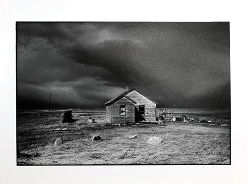
House With Canadian Flag
https://archives.whyte.org/en/permalink/artifactweb.18.12
- Artist
- George Webber
- Date
- 1997 – 1998
- Medium
- photograph on paper
- Catalogue Number
- WeB.18.12
- Description
- Photograph of a house on The Blood Reserve, Alberta with a Canadian flag hanging in the window.
1 image
- Artist
- George Webber
- Title
- House With Canadian Flag
- Date
- 1997 – 1998
- Medium
- photograph on paper
- Dimensions
- 11” x 14” cm
- Description
- Photograph of a house on The Blood Reserve, Alberta with a Canadian flag hanging in the window.
- Credit
- Gift of George Webber, Calgary, 2014
- Catalogue Number
- WeB.18.12
Images
This material is presented as originally created; it may contain outdated cultural descriptions and
potentially offensive content.
Read more.
Lexicon of Canadian stratigraphy Volume 4 Western Canada
https://archives.whyte.org/en/permalink/catalogue26421
- Medium
- Library - Book (including soft-cover and pamphlets)
- Published Date
- 1990
- Publisher
- Calgary, AB : Canadian Society of Petroleum Geologists
- Call Number
- 03 G46l
- Responsibility
- edited by Glass, D.J.
- Publisher
- Calgary, AB : Canadian Society of Petroleum Geologists
- Published Date
- 1990
- Physical Description
- 772pages,23.5cm
- Subjects
- Geological Map
- Geology
- Canada
- Notes
- Ben Gadd Personal Library
- ISBN
- 0920230237
- Accession Number
- 2021.20
- Call Number
- 03 G46l
- Collection
- Archives Library
This material is presented as originally created; it may contain outdated cultural descriptions and
potentially offensive content.
Read more.

Map from the Pacific Ocean across the Rocky Mountain Zone
https://archives.whyte.org/en/permalink/catalogue24555
- Medium
- Library - Maps and blueprints (unannotated; published)
- Map
- Published Date
- January 1874
- Call Number
- C11-3.7
- Published Date
- January 1874
- Scale
- Scale: 1/1:584,000 or 25 English Statute miles to 1 inch
- Subjects
- Canada
- Railway routes
- Notes
- Accompanies: "Report on the Explorations and Surveys" 08.5/C16/rep.
- Accession Number
- 10,000
- Call Number
- C11-3.7
- Collection
- Archives Library
This material is presented as originally created; it may contain outdated cultural descriptions and
potentially offensive content.
Read more.
Map of the country between the provinces of Ontario, Quebec and Manitoba
https://archives.whyte.org/en/permalink/catalogue21432
- Medium
- Library - Maps and blueprints (unannotated; published)
- Map
- Published Date
- January, 1874
- Call Number
- C11-3.7(a)
- Published Date
- January, 1874
- Subjects
- Canada
- Railway routes
- Notes
- Accompanies: "Report on the Explorations and Surveys" 08.5/C16/rep
- Distances from Fort Garry (The Stone Fort) to Toronto and Montreal. All rail routes
- Accession Number
- 10,000
- Call Number
- C11-3.7(a)
- Collection
- Archives Library
This material is presented as originally created; it may contain outdated cultural descriptions and
potentially offensive content.
Read more.
Natural hazards
https://archives.whyte.org/en/permalink/catalogue24366
- Medium
- Library - Maps and blueprints (unannotated; published)
- Map
- Published Date
- 1996
- Publisher
- Vanier (Ont.) : Canadian Geographic ; Nepean (Ont.) : Canada Map Office
- Call Number
- C6-14.1
- Publisher
- Vanier (Ont.) : Canadian Geographic ; Nepean (Ont.) : Canada Map Office
- Published Date
- 1996
- Physical Description
- 7 maps on 1 sheet : col.
- Scale
- Scales vary
- Series
- National Atlas of Canada
- Notes
- Textual information, charts, etc., accompanying maps
- Accession Number
- 29,000
- Call Number
- C6-14.1
- Collection
- Archives Library
This material is presented as originally created; it may contain outdated cultural descriptions and
potentially offensive content.
Read more.
The outdoor traveler's guide Canada
https://archives.whyte.org/en/permalink/catalogue26269
- Medium
- Library - Book (including soft-cover and pamphlets)
- Published Date
- 1991
- Author
- Dunbar, David
- Publisher
- New York, USA : Stewart, Tabori & Chang, Inc.
- Call Number
- 02.4 D91t
- Author
- Dunbar, David
- Responsibility
- Photography by First Light Associated Photographers
- Publisher
- New York, USA : Stewart, Tabori & Chang, Inc.
- Published Date
- 1991
- Physical Description
- 399 pages, 21.6cm
- Series
- The outdoor traveler's guide
- Subjects
- Canada
- Travel
- Photography
- Abstract
- Illustrated guidebook of 37 parks accross the country with full colour images and maps -- back cover
- Contents
- The West -- The Praries -- Central Canada -- Atlantic Canada -- The North
- Notes
- Special handwritten dedication to Ben Gadd from the author. The author also left his signed business card with a thank you dedication to Ben Gadd. The business card has his name, address, and phone number.
- Ben Gadd Personal Library
- ISBN
- 1556701691
- Accession Number
- 2021.20
- Call Number
- 02.4 D91t
- Collection
- Archives Library
This material is presented as originally created; it may contain outdated cultural descriptions and
potentially offensive content.
Read more.

Plans of the Rivers Kamanistiquia and Nepigon
https://archives.whyte.org/en/permalink/catalogue24557
- Medium
- Library - Maps and blueprints (unannotated; published)
- Map
- Published Date
- January 1874
- Publisher
- Canadian Pacific Railway 08.5/C16/rep
- Call Number
- C11-3.7(e)
- Publisher
- Canadian Pacific Railway 08.5/C16/rep
- Published Date
- January 1874
- Scale
- Kamenestiquia Plan: 4000' - 1 inch
- Subjects
- Canada
- Railway routes
- Notes
- To accompany report of the Engineer-in-chief
- Accession Number
- 10,000
- Call Number
- C11-3.7(e)
- Collection
- Archives Library
This material is presented as originally created; it may contain outdated cultural descriptions and
potentially offensive content.
Read more.
Profile : Dr. Paul C. Paquet.
https://archives.whyte.org/en/permalink/catalogue3011
- Medium
- Library - Periodical
- Published Date
- 1996
- Publisher
- Toronto : World Wildlife Fund Canada
- Call Number
- P
- Publisher
- Toronto : World Wildlife Fund Canada
- Published Date
- 1996
- Physical Description
- p.5
- Medium
- Library - Periodical
- Subjects
- Bears, Grizzly
- Canada
- National parks
- Research
- Call Number
- P
- Collection
- Archives Library
This material is presented as originally created; it may contain outdated cultural descriptions and
potentially offensive content.
Read more.
- Date
- 1997 – 2000
- Material
- plastic
- Catalogue Number
- 105.05.048 a-i
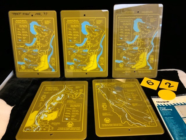
- Description
- 5 Parks Canada trail network map signs from the Jasper area. signs are Plastic, army green with yellow and blue printed maps and clear face. All have the Parks Canada and friends of Jasper National Park logos. There are holes at top and bottom for mounting on signposts. a) Pyramid bench, Jasper tra…
1 image
- Title
- Trail Signage
- Date
- 1997 – 2000
- Material
- plastic
- Dimensions
- 33.0 x 23.5 cm
- Description
- 5 Parks Canada trail network map signs from the Jasper area. signs are Plastic, army green with yellow and blue printed maps and clear face. All have the Parks Canada and friends of Jasper National Park logos. There are holes at top and bottom for mounting on signposts. a) Pyramid bench, Jasper trail sign. “TEST SIGN Feb, ‘97” written in marker at the top of the sign. “c. 1997” is at the bottom right of the sign. b) Pyramid bench, Jasper trail sign, “c. 1997” is at the bottom right of the sign. c) Pyramid bench, Jasper trail sign, “c. 2000” is at the bottom right of the sign. Colours are less vibrant than a and b and sign is 35.0 cm high. d) Old Fort Point to Wabasso Lake trail sign. “c. 1997” at bottom right. “VANDALISM TESTING” written in marker at top. The sign has one large scratched out portion, smaller scratches on the front plastic and back, chips at the right edge, and small dots of paint. e) Maligne Canyon to Old Fort Point trail sign. f-h) small yellow trail number markers. f) diamond shape with “6”. g) smaller diamond shape with “2”, h) blank circle. i_ package of yellow Chartpak vinyl lettering. Partially used.
- Credit
- Gift of Ben Gadd, Banff, 2021
- Catalogue Number
- 105.05.048 a-i
Images
This material is presented as originally created; it may contain outdated cultural descriptions and
potentially offensive content.
Read more.
The wild north land : being the story of a winter journey, with dogs across northern North America
https://archives.whyte.org/en/permalink/catalogue575
- Medium
- Library - Book (including soft-cover and pamphlets)
- Published Date
- 1874
- Author
- Butler, Sir William Francis
- Publisher
- Montreal : Dawson Brothers
- Call Number
- F1060.9 B91
- Author
- Butler, Sir William Francis
- Publisher
- Montreal : Dawson Brothers
- Published Date
- 1874
- Subjects
- Canada
- Call Number
- F1060.9 B91
- Collection
- Alpine Club of Canada Library
This material is presented as originally created; it may contain outdated cultural descriptions and
potentially offensive content.
Read more.