Narrow Results By
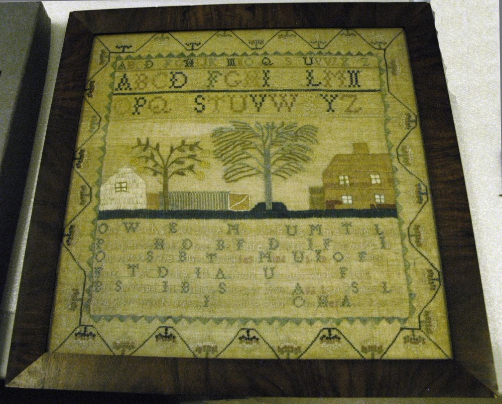
Embroidery Sampler
https://archives.whyte.org/en/permalink/artifact107.02.1007%20a-c
- Date
- 1799
- Material
- fibre; wood
- Catalogue Number
- 107.02.1007 a-c
- Description
- Traditional sampler, 4.0 wide border is a line of stitching in pyramid shapes with flower baskets. At the top of inside border is the upper case alphabet, one line of small letters, other in bigger letters and two lines. In the centre is a picture of a white house to the left, a green picket f…
1 image
- Title
- Embroidery Sampler
- Date
- 1799
- Material
- fibre; wood
- Dimensions
- 42.0 x 42.0 cm
- Description
- Traditional sampler, 4.0 wide border is a line of stitching in pyramid shapes with flower baskets. At the top of inside border is the upper case alphabet, one line of small letters, other in bigger letters and two lines. In the centre is a picture of a white house to the left, a green picket fence, two trees and to the right a two storey brown house. Below that is six lines of writing beginning "One Weeks Extremity May Teach Us ....." "Susan Lehman her work done In the ninth year Of Her Age (__ ?) 1799" * Someone numbered the labels as (a) and (b) and the sampler as (c). It is too fragile to change
- Credit
- Gift of Charles C. Reid, Banff, Alberta, 1986
- Catalogue Number
- 107.02.1007 a-c
Images
This material is presented as originally created; it may contain outdated cultural descriptions and
potentially offensive content.
Read more.
A map showing the communication of the lakes and rivers between Lake Superior and Slave Lake in North America
https://archives.whyte.org/en/permalink/catalogue24545
- Medium
- Library - Maps and blueprints (unannotated; published)
- Map
- Published Date
- 1790
- Publisher
- Gent. Mag.
- Call Number
- C11-1.7
- Publisher
- Gent. Mag.
- Published Date
- 1790
- Physical Description
- 1 map
- Scale
- Scale indeterminable
- Subjects
- Rivers
- The West, Canadian
- Accession Number
- 12,500
- Call Number
- C11-1.7
- Collection
- Archives Library
This material is presented as originally created; it may contain outdated cultural descriptions and
potentially offensive content.
Read more.
Map showing the communication of the Lakes and Rivers between Lake Superior and Slave Lake in North America
https://archives.whyte.org/en/permalink/catalogue21338
- Medium
- Library - Maps and blueprints (unannotated; published)
- Map
- Published Date
- 1790
- Publisher
- Gent Mag.
- Call Number
- C5-5.8
- Publisher
- Gent Mag.
- Published Date
- 1790
- Subjects
- Hydrological Maps Canada
- Notes
- From a copy - Gent Mag. 1790
- Accession Number
- 11,500
- Call Number
- C5-5.8
- Collection
- Archives Library
This material is presented as originally created; it may contain outdated cultural descriptions and
potentially offensive content.
Read more.
Travels through Western Canada from April, 1773 to March, 1790
https://archives.whyte.org/en/permalink/catalogue21485
- Medium
- Library - Maps and blueprints (unannotated; published)
- Map
- Published Date
- 1790
- Call Number
- C12-1.9
- Published Date
- 1790
- Subjects
- Peter Pond's Travels
- Notes
- Photostatic copy from Public Archives
- Accession Number
- 675
- Call Number
- C12-1.9
- Collection
- Archives Library
This material is presented as originally created; it may contain outdated cultural descriptions and
potentially offensive content.
Read more.