Narrow Results By
Alberta and British Columbia [road map]
https://archives.whyte.org/en/permalink/catalogue24411
- Medium
- Library - Maps and blueprints (unannotated; published)
- Map
- Published Date
- 1953
- Publisher
- Imperial Esso Touring Service
- Call Number
- C9-1.21
- Publisher
- Imperial Esso Touring Service
- Published Date
- 1953
- Physical Description
- 8 maps on 1 sheet : col
- Scale
- Scale: 1 inch = ca 30 1/2 miles
- Subjects
- Alberta
- British Columbia
- Notes
- Contents : Alberta. -- British Columbia
- Insets feature maps of Edmonton, Calgary, Vancouver, Victoria, Alaska Highway, Fraser Valley. Cover features Waterton Lakes with Prince of Wales Hotel
- Accession Number
- 6787
- Call Number
- C9-1.21
- Collection
- Archives Library
This material is presented as originally created; it may contain outdated cultural descriptions and
potentially offensive content.
Read more.
[Alberta] Resources and Development
https://archives.whyte.org/en/permalink/catalogue24423
- Medium
- Library - Maps and blueprints (unannotated; published)
- Map
- Published Date
- 1952
- Publisher
- A. Shnitka, Qheens' Printer for Alberta
- Call Number
- C9-5.1
- Publisher
- A. Shnitka, Qheens' Printer for Alberta
- Published Date
- 1952
- Physical Description
- 1 map : col
- Scale
- Scale: 1 inch: 20 miles
- Subjects
- Alberta
- Accession Number
- 372
- Call Number
- C9-5.1
- Collection
- Archives Library
This material is presented as originally created; it may contain outdated cultural descriptions and
potentially offensive content.
Read more.
[Anahim Lake 93C, B.C.]
https://archives.whyte.org/en/permalink/catalogue24005
- Medium
- Library - Maps and blueprints (unannotated; published)
- Map
- Published Date
- 1955
- Publisher
- Dept. of Mines and Technical Surveys
- Call Number
- NTS
- 93C
- Publisher
- Dept. of Mines and Technical Surveys
- Published Date
- 1955
- Physical Description
- 1 map : col
- Scale
- Scale: 1:250,000
- Relief: Contour interval 500 ft.
- Subjects
- Anahim Lake
- British Columbia
- Accession Number
- 3000
- Call Number
- NTS
- 93C
- Collection
- Archives Library
This material is presented as originally created; it may contain outdated cultural descriptions and
potentially offensive content.
Read more.
Athabasca Falls
https://archives.whyte.org/en/permalink/catalogue16404
- Medium
- Library - Postcard
- Published Date
- ca. 1953
- Author
- Gibbons, Wm. JL (Bill Gibbons)
- Publisher
- Canada in Colour Limited
- Call Number
- V295/PG-3
1 image
- Place
- Banff-Jasper-Alberta, Canada
- Publisher
- Canada in Colour Limited
- Published Date
- ca. 1953
- Medium
- Library - Postcard
- Notes
- colour
- reproduced from anso Colour transparencies
- Accession Number
- 17500
- Call Number
- V295/PG-3
Images

This material is presented as originally created; it may contain outdated cultural descriptions and
potentially offensive content.
Read more.
[Athabaska Falls 83C/12, Alberta]
https://archives.whyte.org/en/permalink/catalogue23455
- Medium
- Library - Maps and blueprints (unannotated; published)
- Map
- Published Date
- 1955
- Publisher
- Dept. of National Defence
- Call Number
- NTS
- 83C/12
- Publisher
- Dept. of National Defence
- Published Date
- 1955
- Physical Description
- 1 map : col
- Scale
- Scale: 1:50,000
- Relief: Contour interval 100'
- Subjects
- Athabaska Falls
- Alberta
- Notes
- National Topographic System
- Call Number
- NTS
- 83C/12
- Collection
- Archives Library
This material is presented as originally created; it may contain outdated cultural descriptions and
potentially offensive content.
Read more.
[Atlin 104N, B.C.]
https://archives.whyte.org/en/permalink/catalogue24007
- Medium
- Library - Maps and blueprints (unannotated; published)
- Map
- Published Date
- 1954
- Publisher
- Dept. of Mines and Technical Surveys
- Call Number
- NTS
- 104N
- Publisher
- Dept. of Mines and Technical Surveys
- Published Date
- 1954
- Physical Description
- 1 map : col
- Scale
- Scale: 1:250,000
- Relief: Contour interval 500 ft.
- Subjects
- Atlin
- British Columbia
- Notes
- National Topographic System
- Accession Number
- 3000
- Call Number
- NTS
- 104N
- Collection
- Archives Library
This material is presented as originally created; it may contain outdated cultural descriptions and
potentially offensive content.
Read more.
[Banff 820/4 East, Alta.-B.C.]
https://archives.whyte.org/en/permalink/catalogue23479
- Medium
- Library - Maps and blueprints (unannotated; published)
- Map
- Published Date
- 1959
- Publisher
- Dept. of Mines and Technical Surveys
- Call Number
- NTS
- 820/4E
- Publisher
- Dept. of Mines and Technical Surveys
- Published Date
- 1959
- Physical Description
- 1 map : col
- Scale
- Scale: 1:50,000
- Relief: Contour interval 100 ft.
- Subjects
- Banff
- Alberta/British Columbia
- Notes
- National Topographic System
- Dup in map room
- Dup in research room
- Accession Number
- 718
- 3000
- Call Number
- NTS
- 820/4E
- Collection
- Archives Library
This material is presented as originally created; it may contain outdated cultural descriptions and
potentially offensive content.
Read more.
[Banff 820/4 West, Alta.-B.C.]
https://archives.whyte.org/en/permalink/catalogue23480
- Medium
- Library - Maps and blueprints (unannotated; published)
- Map
- Published Date
- 1959
- Publisher
- Dept. of Mines and Technical Surveys
- Call Number
- NTS
- 829/4W
- Publisher
- Dept. of Mines and Technical Surveys
- Published Date
- 1959
- Physical Description
- 1 map : col
- Scale
- Scale: 1:50,000
- Relief: Contour interval 100 ft.
- Subjects
- Banff
- Alberta/British Columbia
- Notes
- National Topographic System
- Dup in map room
- Dup in research room
- Accession Number
- 718
- 3000
- Call Number
- NTS
- 829/4W
- Collection
- Archives Library
This material is presented as originally created; it may contain outdated cultural descriptions and
potentially offensive content.
Read more.
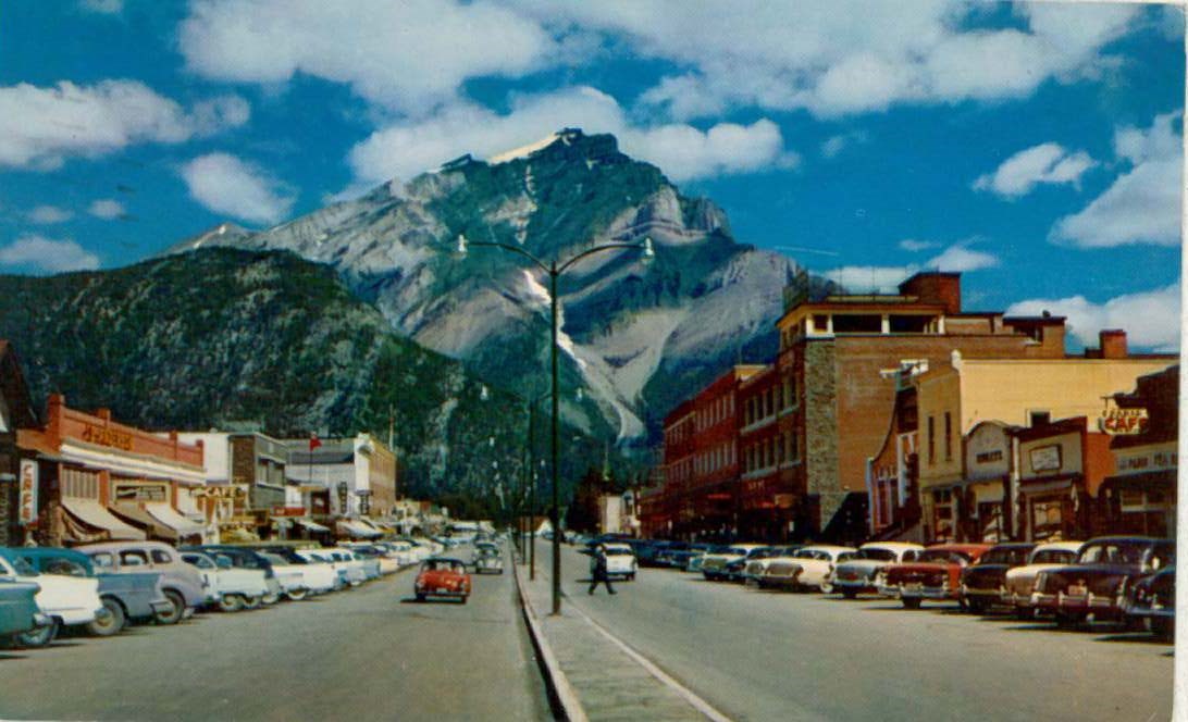
Banff Avenue, Banff, and Cascade Mtn (alt. 9,836 feet), Banff National Park, Canadian Rockies
https://archives.whyte.org/en/permalink/catalogue16292
- Medium
- Library - Postcard
- Published Date
- 1958
- Author
- Harmon, Byron
- Publisher
- Scenic Art
- Call Number
- V222-PG-1
1 image
- Variant Title
- Banff Avenue, Banff, and Cascade Mtn. [Cascade Mountain]
- Author
- Harmon, Byron
- Responsibility
- Byron Harmon Photos
- Place
- Richmond California
- Publisher
- Scenic Art
- Published Date
- 1958
- Medium
- Library - Postcard
- Abstract
- On back of postcard: Scenes in Natural Color
- Notes
- Annotated
- colour
- Includes postage stamp
- Accession Number
- 5046
- Call Number
- V222-PG-1
Images
This material is presented as originally created; it may contain outdated cultural descriptions and
potentially offensive content.
Read more.
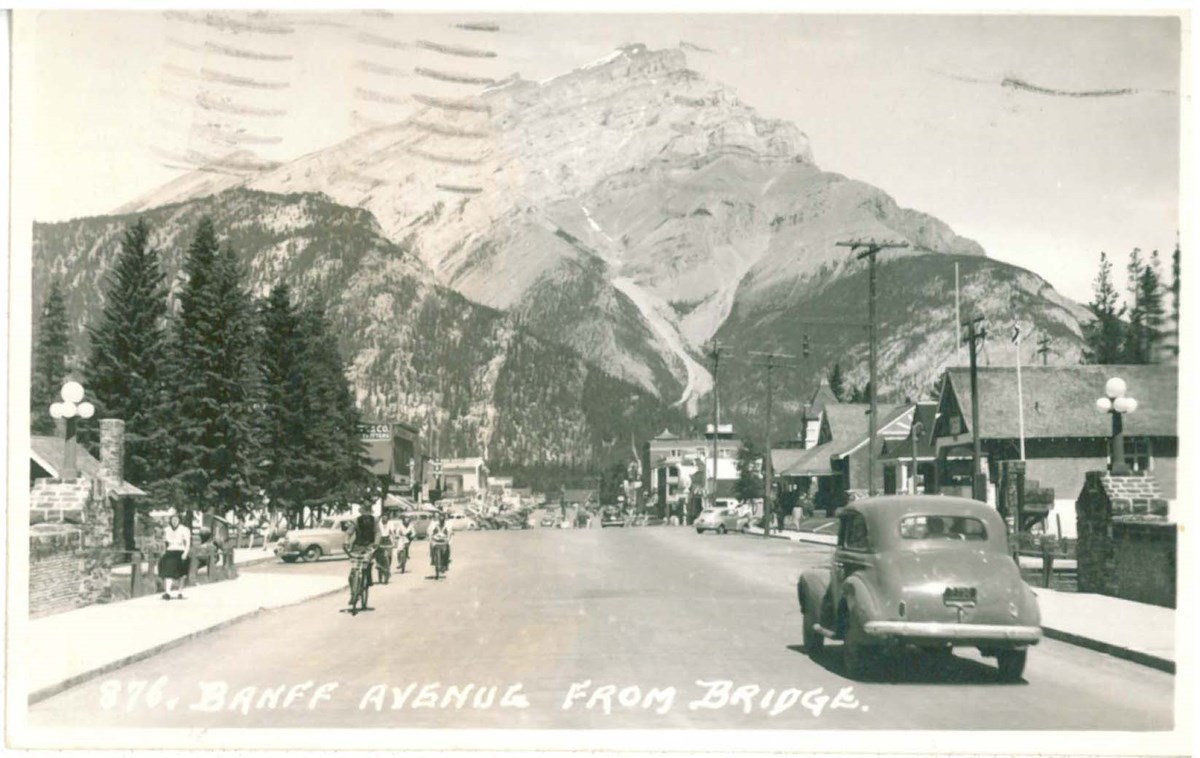
Banff Avenue from Bridge
https://archives.whyte.org/en/permalink/catalogue16919
- Medium
- Library - Postcard
- Published Date
- ca. 1951
- Author
- Harmon, Byron
- Call Number
- V466/PG-B99-85
1 image
- Variant Title
- Along the line of the Canadian Pacific Railway
- Author
- Harmon, Byron
- Responsibility
- Byron Harmon
- Place
- Made in Canada
- Published Date
- ca. 1951
- Medium
- Library - Postcard
- Notes
- Annotated
- b&w
- Includes postage stamp
- Accession Number
- 7227
- Call Number
- V466/PG-B99-85
Images
This material is presented as originally created; it may contain outdated cultural descriptions and
potentially offensive content.
Read more.
- Medium
- Library - Maps and blueprints (unannotated; published)
- Map
- Published Date
- 1955
- Publisher
- Department of Mines and Technical Surveys
- Call Number
- C2-1.4
- Publisher
- Department of Mines and Technical Surveys
- Published Date
- 1955
- Physical Description
- 1 map : col
- Scale
- Scale: 1 in. to 3 miles
- Relief: Contour interval 250'
- Subjects
- Banff National Park
- Accession Number
- 400
- 673
- 3000 Deaccessioned (2)
- 3349 Deaccessioned
- Call Number
- C2-1.4
- Collection
- Archives Library
This material is presented as originally created; it may contain outdated cultural descriptions and
potentially offensive content.
Read more.
- Medium
- Library - Maps and blueprints (unannotated; published)
- Map
- Published Date
- 1955, 1974
- Publisher
- Department of Mines and Technical Surveys
- Edition
- interim corrections 1974
- Call Number
- C2-1.4 (a)
- Edition
- interim corrections 1974
- Publisher
- Department of Mines and Technical Surveys
- Published Date
- 1955, 1974
- Physical Description
- 1 map : col
- Scale
- Scale: 1 in. to 3 miles
- Relief: Contour interval 250 ft.
- Accession Number
- 5319
- 7000 Deaccessioned
- Call Number
- C2-1.4 (a)
- Collection
- Archives Library
This material is presented as originally created; it may contain outdated cultural descriptions and
potentially offensive content.
Read more.
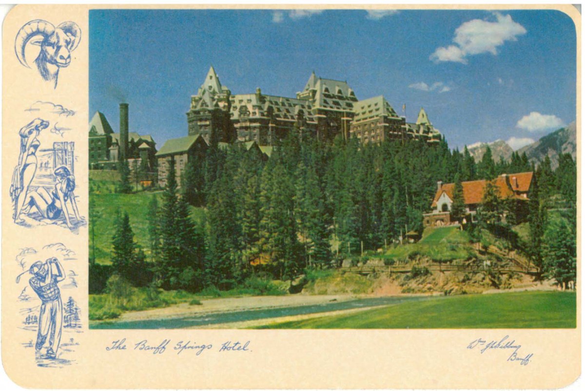
The Banff Springs Hotel
https://archives.whyte.org/en/permalink/catalogue16945
- Medium
- Library - Postcard
- Published Date
- ca. 1953
- Author
- Gibbons, Wm. JL (Bill Gibbons)
- Publisher
- Canada in Colour Limited
- Call Number
- V466/PG-C16-1
1 image
- Place
- Banff-Jasper-Alberta, Canada
- Publisher
- Canada in Colour Limited
- Published Date
- ca. 1953
- Medium
- Library - Postcard
- Notes
- colour
- reproduced from anso Colour transparencies
- Accession Number
- 7239
- Call Number
- V466/PG-C16-1
Images
This material is presented as originally created; it may contain outdated cultural descriptions and
potentially offensive content.
Read more.
Banff Springs Hotel, Rocky Mountains, Canada
https://archives.whyte.org/en/permalink/catalogue17010
- Medium
- Library - Postcard
- Published Date
- ca. 1955
- Publisher
- Folkard Company of Canada Limited
- Call Number
- V466/PG-F71-2
1 image
- Place
- Montreal Printed in Canada
- Publisher
- Folkard Company of Canada Limited
- Published Date
- ca. 1955
- Medium
- Library - Postcard
- Notes
- Annotated
- colour
- Includes postage stamp
- Accession Number
- 6428
- Call Number
- V466/PG-F71-2
Images

This material is presented as originally created; it may contain outdated cultural descriptions and
potentially offensive content.
Read more.
[Banff Townsite]
https://archives.whyte.org/en/permalink/catalogue23269
- Medium
- Library - Maps and blueprints (unannotated; published)
- Map
- Published Date
- November, 1955
- Publisher
- Winnipeg: Western Canada Insurance Underwriters Ass'n
- Call Number
- C4-1.14(a), 1955
- Publisher
- Winnipeg: Western Canada Insurance Underwriters Ass'n
- Published Date
- November, 1955
- Scale
- Scale: 1"-800'
- Subjects
- Banff townsite
- Notes
- 4 sheets of maps showing Business Lots, Recreation Areas, Population, Schools of Banff townsite in 1955.
- See also: C4-1.14
- Fire insurance map
- Accession Number
- 2678
- Call Number
- C4-1.14(a), 1955
- Collection
- Archives Library
This material is presented as originally created; it may contain outdated cultural descriptions and
potentially offensive content.
Read more.
[Bearberry 820/15 East, Alberta]
https://archives.whyte.org/en/permalink/catalogue23486
- Medium
- Library - Maps and blueprints (unannotated; published)
- Map
- Published Date
- 1956
- Publisher
- Dept. of Mines and Technical Surveys
- Call Number
- NTS
- 820/15E
- Publisher
- Dept. of Mines and Technical Surveys
- Published Date
- 1956
- Physical Description
- 1 map : col
- Scale
- Scale: 1:50,000
- Relief: Contour interval 100'
- Notes
- National Topographic System
- Call Number
- NTS
- 820/15E
- Collection
- Archives Library
This material is presented as originally created; it may contain outdated cultural descriptions and
potentially offensive content.
Read more.
[Beavermouth 82N/11 East, B.C.]
https://archives.whyte.org/en/permalink/catalogue23493
- Medium
- Library - Maps and blueprints (unannotated; published)
- Map
- Published Date
- 1959
- Publisher
- Dept. of Mines and Technical Surveys
- Call Number
- NTS
- 82N/11E
- Publisher
- Dept. of Mines and Technical Surveys
- Published Date
- 1959
- Physical Description
- 1 map : col
- Scale
- Scale: 1:50,000
- Relief: Contour itnerval 100'
- Subjects
- Beavermouth
- Eastern British Columbia
- Notes
- National Topographic System
- Call Number
- NTS
- 82N/11E
- Collection
- Archives Library
This material is presented as originally created; it may contain outdated cultural descriptions and
potentially offensive content.
Read more.
[Beavermouth 82N/11 West, B.C.]
https://archives.whyte.org/en/permalink/catalogue23494
- Medium
- Library - Maps and blueprints (unannotated; published)
- Map
- Published Date
- 1959
- Publisher
- Dept. of Mines and Techinical Surveys
- Call Number
- NTS
- 82N/11W
- Publisher
- Dept. of Mines and Techinical Surveys
- Published Date
- 1959
- Physical Description
- 1 map : col
- Scale
- Scale: 1: 50,000
- Relief: Contour interval 100'
- Subjects
- Beavermouth
- Western British Columbia
- Notes
- Beavermouth
- National Topographic System
- Call Number
- NTS
- 82N/11W
- Collection
- Archives Library
This material is presented as originally created; it may contain outdated cultural descriptions and
potentially offensive content.
Read more.
Blaeberry : Kootenay District British Columbia west of fifth meridian
https://archives.whyte.org/en/permalink/catalogue24280
- Medium
- Library - Maps and blueprints (unannotated; published)
- Map
- Published Date
- 1959
- Publisher
- Ottawa : Dept. of Mines and Technical Surveys
- Edition
- 1 ed
- Call Number
- NTS
- 82 N6E
- Edition
- 1 ed
- Publisher
- Ottawa : Dept. of Mines and Technical Surveys
- Published Date
- 1959
- Physical Description
- 1 map : col
- Scale
- Scale: 1:50,000
- Relief: Contour interval 100'
- Accession Number
- 2015.8516 accession changed to 2015.8538
- 2015.8516
- Call Number
- NTS
- 82 N6E
- Collection
- Archives Library
This material is presented as originally created; it may contain outdated cultural descriptions and
potentially offensive content.
Read more.
Blaeberry : Kootenay District British Columbia west of fifth meridian
https://archives.whyte.org/en/permalink/catalogue24284
- Medium
- Library - Maps and blueprints (unannotated; published)
- Map
- Published Date
- 1959
- Publisher
- Ottawa : Dept. of Mines and Techinical Surveys
- Edition
- 1 ed
- Call Number
- NTS
- 82 N6W
- Edition
- 1 ed
- Publisher
- Ottawa : Dept. of Mines and Techinical Surveys
- Published Date
- 1959
- Physical Description
- 1 map : col
- Scale
- Scale: 1: 50,000
- Relief: Contour interval 100'
- Accession Number
- 2015.8516 accession changed to 2015.8538
- 2015.8516
- Call Number
- NTS
- 82 N6W
- Collection
- Archives Library
This material is presented as originally created; it may contain outdated cultural descriptions and
potentially offensive content.
Read more.