Narrow Results By
- Catharine Robb Whyte, O. C. (1906 – 1979, Canadian) 57
- Sitting Wind (1925 – 2002, Canadian) 6
- Earl F. Spencer 3
- Cornelius David Krieghoff (1815 – 1872, Canadian) 2
- Henry George Glyde (1906 – 1998, Canadian) 2
- Herbert C. Hahn (1907 – , American) 2
- Alfred Crocker Leighton, R. C. A. (1901 – 1965, Canadian) 1
- Charles Fraser Comfort (1900 – 1994, Canadian) 1
- Dorothy V. Whyte 1
- Duncan Crockford (1920 – 1992) 1
- Homoky, Stephen G. 1
- J. Monroe Thorington (1894 – 1989, American) 1
[Alert Bay 92L, B.C.]
https://archives.whyte.org/en/permalink/catalogue24003
- Medium
- Library - Maps and blueprints (unannotated; published)
- Map
- Published Date
- 1965
- Publisher
- Army Survey Establishment
- Call Number
- NTS
- 92L
- Publisher
- Army Survey Establishment
- Published Date
- 1965
- Physical Description
- 1 map : col
- Scale
- Scale: 1:250,00
- Relief: Contour interval 500 ft.
- Subjects
- Alert Bay
- British Columbia
- Notes
- National Topographic System
- Accession Number
- 5500
- Call Number
- NTS
- 92L
- Collection
- Archives Library
This material is presented as originally created; it may contain outdated cultural descriptions and
potentially offensive content.
Read more.
[Almond Mountain 82E/7]
https://archives.whyte.org/en/permalink/catalogue23447
- Medium
- Library - Maps and blueprints (unannotated; published)
- Map
- Published Date
- 1968
- Publisher
- Department of Energy, Mines and Resources
- Call Number
- NTS
- 82E/7
- Publisher
- Department of Energy, Mines and Resources
- Published Date
- 1968
- Physical Description
- 1 map : col
- Scale
- Scale: 1:50,000
- Relief: Contour interval 100 ft.
- Subjects
- Almond Mountain
- Notes
- National Topographic System
- Accession Number
- 7000
- Call Number
- NTS
- 82E/7
- Collection
- Archives Library
This material is presented as originally created; it may contain outdated cultural descriptions and
potentially offensive content.
Read more.
[Alsek River 114 NE, B.C.-Alaska]
https://archives.whyte.org/en/permalink/catalogue24174
- Medium
- Library - Maps and blueprints (unannotated; published)
- Map
- Published Date
- 1965
- Publisher
- Dept. of Mines and Technical Surveys
- Call Number
- NTS
- 114NE
- Publisher
- Dept. of Mines and Technical Surveys
- Published Date
- 1965
- Scale
- Scale: 1:500,000
- Altitude tints
- Subjects
- Alsek River
- British Columbia/Alaska
- Notes
- National Topographic System
- Accession Number
- 3000
- Call Number
- NTS
- 114NE
- Collection
- Archives Library
This material is presented as originally created; it may contain outdated cultural descriptions and
potentially offensive content.
Read more.
Archaeological map of Middle America
https://archives.whyte.org/en/permalink/catalogue24826
- Medium
- Library - Maps and blueprints (unannotated; published)
- Map
- Published Date
- 1968
- Publisher
- National Geographic Society
- Call Number
- C13-2.2
- Publisher
- National Geographic Society
- Published Date
- 1968
- Scale
- 35.5 miles to 1 inch
- Subjects
- Mexico, Central America
- Accession Number
- 673
- Call Number
- C13-2.2
- Collection
- Archives Library
This material is presented as originally created; it may contain outdated cultural descriptions and
potentially offensive content.
Read more.
- Medium
- Library - Maps and blueprints (unannotated; published)
- Map
- Published Date
- 1966
- Publisher
- Department of Lands & Forests
- Call Number
- NTS
- 92I/NW
- Publisher
- Department of Lands & Forests
- Published Date
- 1966
- Physical Description
- 1 map : col
- Scale
- Scale: 1:126,720
- Relief: contour interval 100 ft.
- Subjects
- Ashcroft
- British Columbia
- Notes
- National Topographic System
- Accession Number
- 3000
- Call Number
- NTS
- 92I/NW
- Collection
- Archives Library
This material is presented as originally created; it may contain outdated cultural descriptions and
potentially offensive content.
Read more.
[Ashcroft 92I, B.C.]
https://archives.whyte.org/en/permalink/catalogue24006
- Medium
- Library - Maps and blueprints (unannotated; published)
- Map
- Published Date
- 1962
- Publisher
- Dept. of Mines and Technical Surveys
- Call Number
- NTS
- 92I
- Publisher
- Dept. of Mines and Technical Surveys
- Published Date
- 1962
- Physical Description
- 1 map : col
- Scale
- Scale: 1:250,000
- Relief: Contour interval 500 ft.
- Subjects
- Ashcroft
- British Columbia
- Notes
- National Topographic System
- Accession Number
- 3000
- Call Number
- NTS
- 92I
- Collection
- Archives Library
This material is presented as originally created; it may contain outdated cultural descriptions and
potentially offensive content.
Read more.
[Ashnola 92H/1 East, B.C.]
https://archives.whyte.org/en/permalink/catalogue23452
- Medium
- Library - Maps and blueprints (unannotated; published)
- Map
- Published Date
- 1960
- Publisher
- Army Survey Establishment
- Call Number
- NTS
- 92H/1E
- Publisher
- Army Survey Establishment
- Published Date
- 1960
- Physical Description
- 1 map : col
- Scale
- Scale: 1:50,000
- Relief: Contour interval 100 ft.
- Subjects
- Ashnola
- British Columbia
- Notes
- National Topographic System
- Accession Number
- 7000
- Call Number
- NTS
- 92H/1E
- Collection
- Archives Library
This material is presented as originally created; it may contain outdated cultural descriptions and
potentially offensive content.
Read more.
[Ashnola 92H/1 West, B.C.]
https://archives.whyte.org/en/permalink/catalogue23453
- Medium
- Library - Maps and blueprints (unannotated; published)
- Map
- Published Date
- 1960
- Publisher
- Army Survey Establishment
- Call Number
- NTS
- 92H/1W
- Publisher
- Army Survey Establishment
- Published Date
- 1960
- Physical Description
- 1 map : col
- Scale
- Scale: 1:50,000
- Relief: Contour interval 100 ft.
- Subjects
- Ashnola
- British Columbia
- Notes
- National Topographic System
- Accession Number
- 7000
- Call Number
- NTS
- 92H/1W
- Collection
- Archives Library
This material is presented as originally created; it may contain outdated cultural descriptions and
potentially offensive content.
Read more.
[Asia, Southeast]
https://archives.whyte.org/en/permalink/catalogue24844
- Medium
- Library - Maps and blueprints (unannotated; published)
- Map
- Published Date
- 1961
- Publisher
- National Geographic Society
- Call Number
- C13-8.2
- Publisher
- National Geographic Society
- Published Date
- 1961
- Scale
- Scale: 130 miles to 1 inch
- Relief: Bench Marks
- Subjects
- Southeast Asia
- Accession Number
- 495
- Call Number
- C13-8.2
- Collection
- Archives Library
This material is presented as originally created; it may contain outdated cultural descriptions and
potentially offensive content.
Read more.
[Asia, Southeast]
https://archives.whyte.org/en/permalink/catalogue24845
- Medium
- Library - Maps and blueprints (unannotated; published)
- Map
- Published Date
- 1968
- Publisher
- National Geographic Society
- Call Number
- C13-8.3
- Publisher
- National Geographic Society
- Published Date
- 1968
- Scale
- Scale: 94.7 miles to 1 inch
- Subjects
- Southeast, Asia
- Accession Number
- 495
- Call Number
- C13-8.3
- Collection
- Archives Library
This material is presented as originally created; it may contain outdated cultural descriptions and
potentially offensive content.
Read more.
[Aspen Grove 92H/15 B.C.]
https://archives.whyte.org/en/permalink/catalogue23454
- Medium
- Library - Maps and blueprints (unannotated; published)
- Map
- Published Date
- 1968
- Publisher
- Department of Energy, Mines and Resources
- Call Number
- NTS
- 92H/15
- Publisher
- Department of Energy, Mines and Resources
- Published Date
- 1968
- Physical Description
- 1 map : col
- Scale
- Scale: 1:50,000
- Relief: Contour interval 100 ft.
- Subjects
- Aspen Grove
- British Columbia
- Notes
- National Topographic Survey
- Accession Number
- 7000
- Call Number
- NTS
- 92H/15
- Collection
- Archives Library
This material is presented as originally created; it may contain outdated cultural descriptions and
potentially offensive content.
Read more.
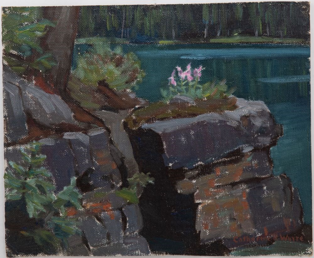
At Lake O'Hara
https://archives.whyte.org/en/permalink/artifactwyc.01.060
- Date
- 1969
- Medium
- oil on canvas
- Catalogue Number
- WyC.01.060
- Description
- Lake O’Hara beyond a rocky outcrop in foreground.
1 image
- Title
- At Lake O'Hara
- Date
- 1969
- Medium
- oil on canvas
- Dimensions
- 22.8 x 28.0 cm
- Description
- Lake O’Hara beyond a rocky outcrop in foreground.
- Subject
- landscape
- Canadian Rockies
- Lake O’Hara
- Credit
- Gift of Catharine Robb Whyte, O. C., Banff, 1979
- Catalogue Number
- WyC.01.060
Images
This material is presented as originally created; it may contain outdated cultural descriptions and
potentially offensive content.
Read more.
[Athabaska River]
https://archives.whyte.org/en/permalink/catalogue24216
- Medium
- Library - Maps and blueprints (unannotated; published)
- Map
- Published Date
- 1964
- Publisher
- Department of Mines & Technical Surveys
- Call Number
- NTS
- 83
- Publisher
- Department of Mines & Technical Surveys
- Published Date
- 1964
- Physical Description
- 1 map : col
- Scale
- Scale: 1:1,000,000
- Relief: Altitude tints
- Subjects
- Athabaska River
- Accession Number
- 3000
- Call Number
- NTS
- 83
- Collection
- Archives Library
This material is presented as originally created; it may contain outdated cultural descriptions and
potentially offensive content.
Read more.
Autumn Storm, Shuswap Lake, B.C.
https://archives.whyte.org/en/permalink/artifactdgo.02.01
- Date
- c. 1970
- Medium
- oil on canvas board
- Catalogue Number
- DgO.02.01
- Description
- Yellow/orange colour dominates from centre to top right; foreground and bottom right are brown trees, higher to the right of picture; behind these trees is a blue lake, yellow reflection; a varied coloured green mountain is in the centre left; light yellow sweeps down from top left.
1 image
- Title
- Autumn Storm, Shuswap Lake, B.C.
- Date
- c. 1970
- Medium
- oil on canvas board
- Dimensions
- 25.5 x 30.5 cm
- Description
- Yellow/orange colour dominates from centre to top right; foreground and bottom right are brown trees, higher to the right of picture; behind these trees is a blue lake, yellow reflection; a varied coloured green mountain is in the centre left; light yellow sweeps down from top left.
- Credit
- Gift of Jock Smith, Vancouver, 1972
- Catalogue Number
- DgO.02.01
Images

This material is presented as originally created; it may contain outdated cultural descriptions and
potentially offensive content.
Read more.
[Baffin Island 37E/1E] District of Franklin, Northwest Territories
https://archives.whyte.org/en/permalink/catalogue23460
- Medium
- Library - Maps and blueprints (unannotated; published)
- Map
- Published Date
- 1964
- Publisher
- Department of Mines and Technical Surveys
- Call Number
- NTS
- 37E/1E
- Publisher
- Department of Mines and Technical Surveys
- Published Date
- 1964
- Physical Description
- 1 map : black and white
- Scale
- Scale: 1:50,000
- Relief: Contour intervals
- Notes
- National Topographic System
- Arctic provisional map
- Accession Number
- 7000
- Call Number
- NTS
- 37E/1E
- Collection
- Archives Library
This material is presented as originally created; it may contain outdated cultural descriptions and
potentially offensive content.
Read more.
[Baffin Island 37E/1W] District of Franklin, Northwest Territories
https://archives.whyte.org/en/permalink/catalogue23461
- Medium
- Library - Maps and blueprints (unannotated; published)
- Map
- Published Date
- 1964
- Publisher
- Department of Mines and Technical Surveys
- Call Number
- NTS
- 37E/1W
- Publisher
- Department of Mines and Technical Surveys
- Published Date
- 1964
- Physical Description
- 1 map : black and white
- Scale
- Scale: 1:50,000
- Relief: Contour Intervals
- Notes
- National Topographic System
- Arctic provisional map
- Accession Number
- 7000
- Call Number
- NTS
- 37E/1W
- Collection
- Archives Library
This material is presented as originally created; it may contain outdated cultural descriptions and
potentially offensive content.
Read more.
[Baffin Island 37E/8E] Bieler Lake East, District of Franklin, Northwest Territories
https://archives.whyte.org/en/permalink/catalogue23471
- Medium
- Library - Maps and blueprints (unannotated; published)
- Map
- Published Date
- 1964
- Publisher
- Department of Mines and Technical Surveys
- Call Number
- NTS
- 37E/8E
- Publisher
- Department of Mines and Technical Surveys
- Published Date
- 1964
- Physical Description
- 1 map : black and white
- Scale
- Scale: 1:50,000
- Relief: Contour intervals
- Notes
- Arctic provisional map
- National Topographic System
- Accession Number
- 7000
- Call Number
- NTS
- 37E/8E
- Collection
- Archives Library
This material is presented as originally created; it may contain outdated cultural descriptions and
potentially offensive content.
Read more.
[Baffin Island 37E/8W] Bieler Lake East, District of Franklin, Northwest Territories
https://archives.whyte.org/en/permalink/catalogue23472
- Medium
- Library - Maps and blueprints (unannotated; published)
- Map
- Published Date
- 1964
- Publisher
- Department of Mines and Technical Surveys
- Call Number
- NTS
- 37E/8E
- Publisher
- Department of Mines and Technical Surveys
- Published Date
- 1964
- Physical Description
- 1 map : black and white
- Scale
- Scale: 1:50,000
- Relief: Contour intervals
- Notes
- Arctic provisional map
- National Topographic System
- Accession Number
- 7000
- Call Number
- NTS
- 37E/8E
- Collection
- Archives Library
This material is presented as originally created; it may contain outdated cultural descriptions and
potentially offensive content.
Read more.
[Baffin Island 47H/1] Provisional Map, District of Franklin, Northwest Territories
https://archives.whyte.org/en/permalink/catalogue23474
- Medium
- Library - Maps and blueprints (unannotated; published)
- Map
- Published Date
- 1968
- Publisher
- Department of Energy, Mines and Resources
- Call Number
- NTS
- 47H/1
- Publisher
- Department of Energy, Mines and Resources
- Published Date
- 1968
- Physical Description
- 1 map : black and white
- Scale
- Scale: 1:50,000
- Relief: Contour interval 50 ft.
- Notes
- National Topographic System
- Accession Number
- 7000
- Call Number
- NTS
- 47H/1
- Collection
- Archives Library
This material is presented as originally created; it may contain outdated cultural descriptions and
potentially offensive content.
Read more.
[Baffin Island 47H/8] Provisional Map, District of Franklin, Northwest Territories
https://archives.whyte.org/en/permalink/catalogue23475
- Medium
- Library - Maps and blueprints (unannotated; published)
- Map
- Published Date
- 1967
- Publisher
- Department of Energy, Mines and Resources
- Call Number
- NTS
- 47H/8
- Publisher
- Department of Energy, Mines and Resources
- Published Date
- 1967
- Physical Description
- 1 map : black and white
- Scale
- Scale: 1:50,000
- Relief: Contour interval 50 ft.
- Accession Number
- 7000
- Call Number
- NTS
- 47H/8
- Collection
- Archives Library
This material is presented as originally created; it may contain outdated cultural descriptions and
potentially offensive content.
Read more.