Narrow Results By
- Alpine Club of Canada fonds 116
- Ben Gadd fonds 55
- Murray Hay fonds 38
- Douglas Leighton fonds 32
- Trail Riders of the Canadian Rockies fonds 15
- Chic Scott fonds 13
- Bruno Engler fonds 5
- Luxton family fonds 5
- Bruce Hatfield fonds 4
- Elmer and Grace Charlton fonds 4
- Aileen Harmon fonds 1
- Alice Fulmer fonds 1
- Part Of
- Murray Hay fonds
- Scope & Content
- File consists of 1 map : col., annotations, 96.5 x 69 cm. File pertains to an original unfinished hand-drawn map of interior Arizona in red, blue, black, and purple ink. Includes geographic features and labeled cities (including Yuma, Nogales, Bisbee, and Flagstaff).
- Date Range
- ca.1990-ca.1999
- Reference Code
- V795 / II / D / i / 4
- Description Level
- 5 / File
- GMD
- Drawing
- Map
- Private record
- Textual record
- Part Of
- Murray Hay fonds
- Description Level
- 5 / File
- Fonds Number
- M570 / V795
- Series
- V795 / II : Unpublished Material
- Sous-Fonds
- V795
- Sub-Series
- V795 / II / D : International / i : United States of America
- Accession Number
- 2019.41
- Reference Code
- V795 / II / D / i / 4
- Date Range
- ca.1990-ca.1999
- Physical Description
- 1 map : col., annotations ; 96.5 x 69 cm
- Scope & Content
- File consists of 1 map : col., annotations, 96.5 x 69 cm. File pertains to an original unfinished hand-drawn map of interior Arizona in red, blue, black, and purple ink. Includes geographic features and labeled cities (including Yuma, Nogales, Bisbee, and Flagstaff).
- Name Access
- Hay, Murray
- Subject Access
- Advertising
- Artist
- Ski Maps
- Map
- Cartography
- Sports and recreation
- Tourism
- Tourist information
- Travel
- Geography
- Winter
- Winter sports
- Ski area
- Geographic Access
- Arizona
- United States
- Language
- English
- Creator
- Hay, Murray
- Title Source
- Title based on contents of file
- Processing Status
- Processed
This material is presented as originally created; it may contain outdated cultural descriptions and
potentially offensive content.
Read more.
ARÊTE [ca. 1994-2016]
https://archives.whyte.org/en/permalink/descriptions57729
- Part Of
- Alpine Club of Canada fonds
- Scope & Content
- File consists of a summit record from Arête Peak produced by the Alpine Club of Canada between around 1994 and 2016. Summit record includes entries from visitors to the various summits which pertain to individuals' hiking and climbing trips; details of specific events which occurred while at the su…
- Date Range
- ca. 1994-2016
- Reference Code
- M200 / V / A / 137
- Description Level
- 5 / File
- GMD
- Textual record
- Organization record
- Part Of
- Alpine Club of Canada fonds
- Description Level
- 5 / File
- Fonds Number
- M200
- V14
- S6
- Series
- M200 / V: Summit Records
- Sous-Fonds
- M200
- Sub-Series
- M200 / V / A: Identified Summit Records
- Accession Number
- accn. 2023.20
- Reference Code
- M200 / V / A / 137
- Responsibility
- Summit Registers and Notes produced by Alpine Club of Canada
- Date Range
- ca. 1994-2016
- Physical Description
- 0.5 cm of textual record 1 volume
- History / Biographical
- Arête Peak is located in Yoho National Park, British Columbia. Nearby are Mount des Poilus and Isolated Peak.
- Scope & Content
- File consists of a summit record from Arête Peak produced by the Alpine Club of Canada between around 1994 and 2016. Summit record includes entries from visitors to the various summits which pertain to individuals' hiking and climbing trips; details of specific events which occurred while at the summit, wildlife sightings, trail updates, and related topics. File: M200 / V / A / 137: ARÊTE [ca. 1994-2016]
- Name Access
- Alpine Club of Canada
- Subject Access
- Alpine Club of Canada
- Backpacking
- British Columbia
- Climbing
- Club
- Description and travel
- Environment
- Environment and Nature
- Hiking
- Mountain
- Mountaineering
- Mountaineers
- Mountains
- National parks and reserves
- Parks Canada
- Record keeping
- Sports and leisure
- Sports and recreation
- Summit
- Trails
- Geographic Access
- Canada
- Canadian Rocky Mountains
- British Columbia
- Yoho National Park
- Access Restrictions
- Restrictions may apply
- Language
- English
- Conservation
- Register contains mold. Register has been placed in mylar.
- Related Material
- M235
- Title Source
- Title based on contents of file
- Processing Status
- Processed
This material is presented as originally created; it may contain outdated cultural descriptions and
potentially offensive content.
Read more.
Author's copies
https://archives.whyte.org/en/permalink/descriptions56289
- Part Of
- Ben Gadd fonds
- Scope & Content
- File consists of author's copies of multiple editions of Ben Gadd's book, Handbook of the Canadian Rockies. Editions in file are annotated with notes and corrections by the author.
- Date Range
- 1991-1992
- 1995
- 1999
- 2003
- Reference Code
- M590 / II / A / 89 to 93
- Description Level
- 5 / File
- GMD
- Published record
- Textual record
- Newspaper clipping
- Part Of
- Ben Gadd fonds
- Description Level
- 5 / File
- Fonds Number
- M590
- V810
- S61
- Series
- M590 / II : Research and publication records
- Sous-Fonds
- M590
- Sub-Series
- M590 / II / A : Handbook of the Canadian Rockies
- Accession Number
- 2021.20
- Reference Code
- M590 / II / A / 89 to 93
- Responsibility
- Produced by Ben Gadd, Corax Press
- Date Range
- 1991-1992
- 1995
- 1999
- 2003
- Physical Description
- 18 cm of textual records : 5 volumes ; 14 x 21 cm
- Scope & Content
- File consists of author's copies of multiple editions of Ben Gadd's book, Handbook of the Canadian Rockies. Editions in file are annotated with notes and corrections by the author.
- Notes
- Volumes in file are arranged by date
- Name Access
- Gadd, Ben
- Subject Access
- Publication
- Research
- Professional and Personal Life
- Travel
- Environment
- Geology
- Natural history
- Wildlife
- Conservation
- National parks and reserves
- Tourism
- Recreation
- Geographic Access
- Canada
- Canadian Rocky Mountains
- Reproduction Restrictions
- Copyright restrictions apply
- Language
- English
- Creator
- Ben Gadd
- Title Source
- Original title used
- Processing Status
- Processed
This material is presented as originally created; it may contain outdated cultural descriptions and
potentially offensive content.
Read more.
Baja California Sur, Mexico
https://archives.whyte.org/en/permalink/descriptions54835
- Part Of
- Murray Hay fonds
- Scope & Content
- File consists of 1 cm of textual records, 21.5 x 36 cm or smaller. File pertains to a project Murray Hay worked on for Glacier Bay Tours and Cruises (based out of Alaska). File is comprised of handwritten and faxed correspondence between Hay and Steve Cowart, Manager, Creative Services. Corresponde…
- Date Range
- ca.1998
- Reference Code
- M570 / IV / A / 1
- Description Level
- 5 / File
- GMD
- Textual record
- Private record
- Map
- Part Of
- Murray Hay fonds
- Description Level
- 5 / File
- Fonds Number
- M570 / V795
- Series
- M570 / IV : Murray Hay Personal Papers
- Sous-Fonds
- M570
- Sub-Series
- M570 / IV / A : Correspondence
- Accession Number
- 2019.41
- Reference Code
- M570 / IV / A / 1
- Date Range
- ca.1998
- Physical Description
- 1 cm of textual records (21.5 x 36 cm or smaller)
- Scope & Content
- File consists of 1 cm of textual records, 21.5 x 36 cm or smaller. File pertains to a project Murray Hay worked on for Glacier Bay Tours and Cruises (based out of Alaska). File is comprised of handwritten and faxed correspondence between Hay and Steve Cowart, Manager, Creative Services. Correspondence is in regards to the map of Baja California Sur, Mexico Hay was to create for the company's promotion of their cruise to the area.
- Notes
- Originally filed with draft material related to this project [see related material].
- Name Access
- Hay, Murray
- Cowart, Steve
- Subject Access
- Advertising
- Artist
- Cartography
- Map
- Tourism
- Travel
- Tourist information
- Geographic Access
- Mexico
- Baja California Sur
- Language
- English
- Related Material
- V795 / II / D / ii / 2-3
- Title Source
- Title based on contents of file
- Processing Status
- Processed
This material is presented as originally created; it may contain outdated cultural descriptions and
potentially offensive content.
Read more.
Baja California Sur, Mexico
https://archives.whyte.org/en/permalink/descriptions54974
- Part Of
- Murray Hay fonds
- Scope & Content
- File consists of 11 maps : mss. and reproductions, some col., annotations ; 43 x 94 cm or smaller. File pertains to a project Murray Hay worked on for Glacier Bay Tours and Cruises (based out of Alaska). File includes 11 original hand-drawn and reproduced drafts, including annotations, of a map dep…
- Date Range
- ca.1990-ca.1999
- ca. 1998
- Reference Code
- V795 / II / D / ii / 2-3
- Description Level
- 5 / File
- GMD
- Drawing
- Map
- Private record
- Part Of
- Murray Hay fonds
- Description Level
- 5 / File
- Fonds Number
- M570 / V795
- Series
- V795 / II : Unpublished Material
- Sous-Fonds
- V795
- Sub-Series
- V795 / II / D : International / ii : Miscellaneous
- Accession Number
- 2019.41
- Reference Code
- V795 / II / D / ii / 2-3
- GMD
- Drawing
- Map
- Private record
- Date Range
- ca.1990-ca.1999
- ca. 1998
- Physical Description
- 11 maps : mss. and reproductions, some col., annotations ; 43 x 94 cm or smaller
- Scope & Content
- File consists of 11 maps : mss. and reproductions, some col., annotations ; 43 x 94 cm or smaller. File pertains to a project Murray Hay worked on for Glacier Bay Tours and Cruises (based out of Alaska). File includes 11 original hand-drawn and reproduced drafts, including annotations, of a map depicting the Baja California Sur region and the cruise's route in this area.
- Notes
- Originally filed with correspondence related to this project [see related material]. "For Steve Cowart" is also written on at least one map (who Murray Hay is corresponding with in M570 / IV / A / 1). Items not in oversize stored in downstairs vault.
- Name Access
- Hay, Murray
- Cowart, Steve
- Subject Access
- Advertising
- Artist
- Cartography
- Map
- Tourism
- Tourist information
- Travel
- Geography
- Geographic Access
- Mexico
- Baja California Sur
- Language
- English
- Related Material
- M570 / IV / A /1
- Creator
- Hay, Murray
- Title Source
- Title based on contents of file
- Processing Status
- Processed
This material is presented as originally created; it may contain outdated cultural descriptions and
potentially offensive content.
Read more.
Balfour Hut Registers
https://archives.whyte.org/en/permalink/descriptions57646
- Part Of
- Alpine Club of Canada fonds
- Scope & Content
- Sub-series of hut registers from the Balfour (Rob Ritchie) Hut produced by the Alpine Club of Canada between 1966 and 2019. Registers include entries from visitors to the huts which pertain to individuals' hiking and climbing trips; details of specific events which occurred while staying at the hut…
- Date Range
- 1966-2001
- 2007-2019
- Reference Code
- M200 / IV / I
- Description Level
- 4 / Sub-series
- GMD
- Textual record
- Organization record
- Part Of
- Alpine Club of Canada fonds
- Description Level
- 4 / Sub-series
- Fonds Number
- M200
- V14
- S6
- Series
- M200 / IV: Hut Registers
- Sous-Fonds
- M200
- Sub-Series
- M200 / IV / I: Balfour Hut Registers
- Accession Number
- accn. 2376
- accn. 3298
- accn. 3560
- accn. 7779
- accn. 2023.10
- accn. 2023.31
- accn. 2023.15
- Reference Code
- M200 / IV / I
- Responsibility
- Registers produced by Alpine Club of Canada
- Date Range
- 1966-2001
- 2007-2019
- Physical Description
- 20 cm of textual records 9 volumes
- History / Biographical
- According to the Alpine Club of Canada's website: "The Rob Ritchie Hut, also known as the Balfour Hut, is found on low, rocky hills at the toe of the Vulture Glacier, approximately 28 km northwest of the town of Lake Louise, AB. It is east of Balfour Pass and the Continental divide, just inside the Banff National Park boundary.[...] The Rob Ritchie Hut, also known as the Balfour Hut, is found on low, rocky hills at the toe of the Vulture Glacier, approximately 28 km northwest of the town of Lake Louise, AB. It is east of Balfour Pass and the Continental divide, just inside the Banff National Park boundary. This is the half-way mark for the Wapta Traverse and is usually used in conjunction with the other huts in this chain while attempting this classic cross-glacier ski trip. Usual approach is from Bow Hut through the Olive/St. Nicholas Col then down the gentle and pleasant Vulture Glacier to Balfour Pass, where the hut sits on a section of moraine beneath the impressive bulk of Mt. Balfour. Though most people will spend one night at the R.J. Ritchie (Balfour) Hut before continuing on to Scott Duncan, there is potential for good skiing here, especially on the Diableret Glacier which sits northwest of Mt. Balfour and makes for a fantastic run on a clear day! There is also an optional route to the summit of Mt. Gordon from this hut, which would be an excellent loop trip if combined with the normal route back towards Bow Hut. Use your imagination and some neat trip ideas will present themselves!"
- Scope & Content
- Sub-series of hut registers from the Balfour (Rob Ritchie) Hut produced by the Alpine Club of Canada between 1966 and 2019. Registers include entries from visitors to the huts which pertain to individuals' hiking and climbing trips; details of specific events which occurred while staying at the hut, wildlife sightings, custodial issues and updates, and related topics. The sub-series is separated into individual hut registers, arranged by date:
- M200 / IV / I / 1: Balfour Hut [Register] [1966-1971]
- M200 / IV / I / 2: Balfour Pass Hut [1971-1972]
- M200 / IV / I / 3: Balfour Pass Hut Register [1973-1974]
- M200 / IV / I / 4: Balfour Pass Hut [register 1974-1982]
- M200 / IV / I / 5: "Balfour Hut" [register] Sept. 2, 1982 - Nov. 17, 1989
- M200 / IV / I / 6: Balfour Hut Journal Nov. 22, 1989 - Apr. 25, 1997
- M200 / IV / I / 7: Balfour Hut Register [1997 -2001]
- M200 / IV / I / 8: Balfour Hut Register 2007 - 2015
- M200 / IV / I / 9: Balfour Hut register 2011 - 2019
- Name Access
- Alpine Club of Canada
- Subject Access
- Huts
- Cabins
- Cabins and shelters
- Backcountry skiing
- Banff National Park
- Buildings and facilities
- Climbing
- Environment and Nature
- Lake Louise
- Mountaineering
- Mountains
- Ski mountaineering
- Sports and leisure
- Sports and recreation
- Winter sports
- Wapta Traverse
- Geographic Access
- Canada
- Alberta
- Banff National Park
- Lake Louise, AB
- Access Restrictions
- Restrictions may apply
- Language
- English
- French
- German
- Japanese
- Spanish
- Biographical Source Notes
- Alpine Club of Canada website: https://www.alpineclubofcanada.ca/rob-ritchie-balfour-hut/"
- Title Source
- Title based on contents of sub-series
- Processing Status
- Processed
This material is presented as originally created; it may contain outdated cultural descriptions and
potentially offensive content.
Read more.
Banff and Jasper National Park
https://archives.whyte.org/en/permalink/descriptions56434
- Part Of
- Douglas Leighton fonds
- Scope & Content
- File consists of photographs of the Banff National Park including photographs of Lake Louise, Moraine Lake and area. also included are photographs of Jasper National Park
- Date Range
- 1988
- 1989
- 1990
- 1991
- 1992
- 1995
- Reference Code
- V222 / IV / C / 12 / NS - 1 to 163
- Description Level
- 5 / File
- GMD
- Photograph
- Transparency
- Part Of
- Douglas Leighton fonds
- Description Level
- 5 / File
- Fonds Number
- M133
- V222
- Series
- V222 / IV : Scenic Views
- Sous-Fonds
- V222
- Sub-Series
- V222 / IV / C: Alberta
- Accession Number
- 2020.24
- Reference Code
- V222 / IV / C / 12 / NS - 1 to 163
- Date Range
- 1988
- 1989
- 1990
- 1991
- 1992
- 1995
- Physical Description
- 163 photographs : col. slides ; 35 mm
- Scope & Content
- File consists of photographs of the Banff National Park including photographs of Lake Louise, Moraine Lake and area. also included are photographs of Jasper National Park
- Name Access
- Leighton, Douglas
- Subject Access
- Activities
- Tourism
- scenic
- Geographic Access
- Alberta
- Jasper National Park
- Banff National Park
- Language
- English
- Creator
- Douglas Leighton
- Category
- Sports, recreation and leisure
- Tourism
- Title Source
- Title based on contents of file
- Processing Status
- Processed
This material is presented as originally created; it may contain outdated cultural descriptions and
potentially offensive content.
Read more.
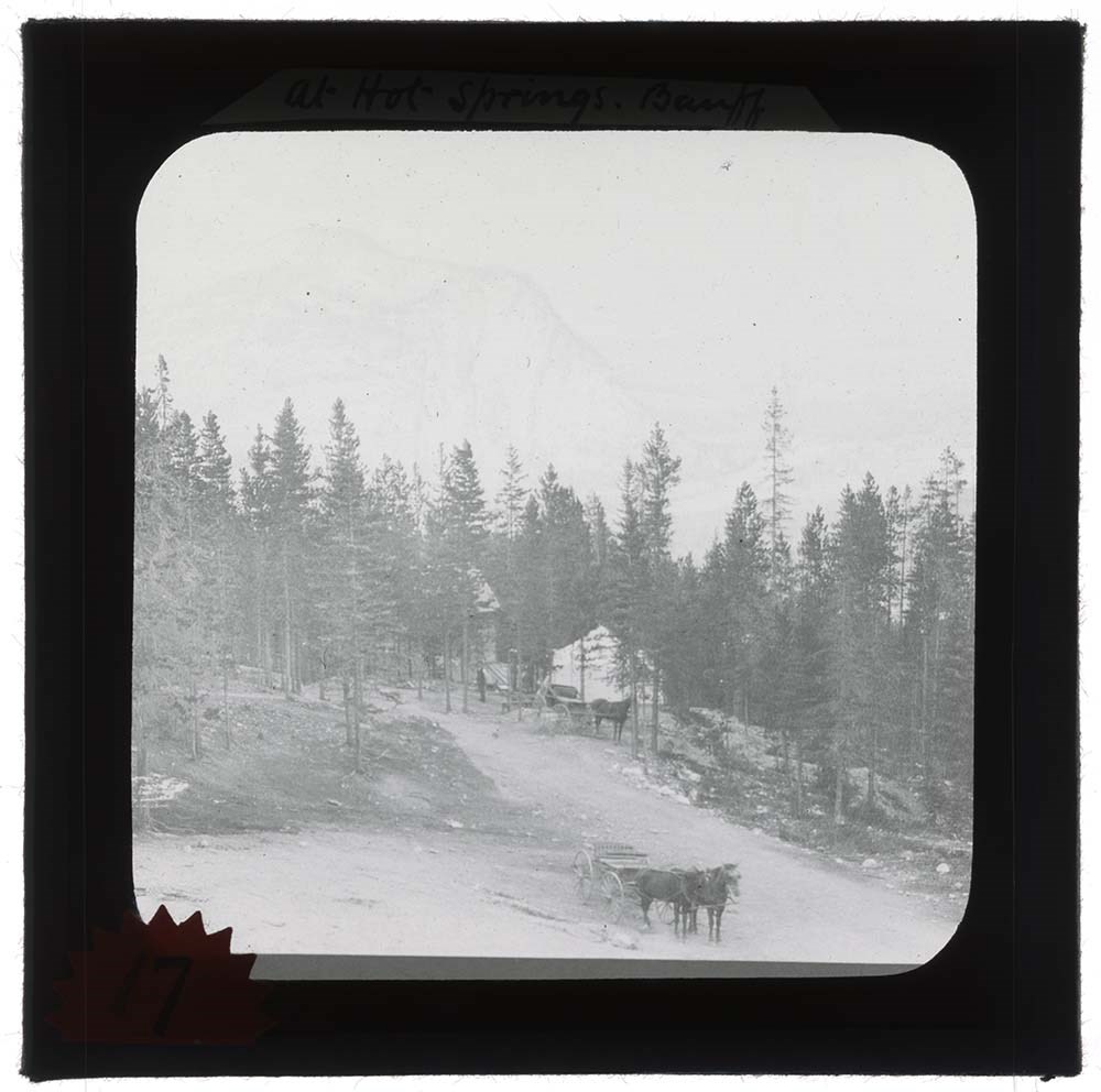
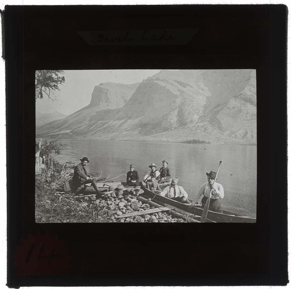
Banff Lantern Slides
https://archives.whyte.org/en/permalink/descriptions21760
- Part Of
- Archives General File Collection
- Scope & Content
- Series consists of 4 lantern slides. Slides are views of the Banff Hot Springs, Banff Avenue with Cascade Mountain, Devil's Lake, and the city of Calgary.
- Date Range
- [c. 1890]
- Reference Code
- V8 / 7919 / PS - 1 to PS - 4
- Description Level
- 3 / Series
- GMD
- Transparency
- Lantern slide
4 images
- Part Of
- Archives General File Collection
- Description Level
- 3 / Series
- Fonds Number
- M8 / V8 / S8
- Series
- Accession Number : 7919
- Sous-Fonds
- V8
- Accession Number
- 7919
- Reference Code
- V8 / 7919 / PS - 1 to PS - 4
- Date Range
- [c. 1890]
- Physical Description
- 4 photographs : b&w slides ; 8.2 x 8.2 cm
- Scope & Content
- Series consists of 4 lantern slides. Slides are views of the Banff Hot Springs, Banff Avenue with Cascade Mountain, Devil's Lake, and the city of Calgary.
- Subject Access
- Lantern slide
- Tourism
- Geographic Access
- Banff
- Calgary
- Alberta
- Canada
- Language
- English
- Conservation
- All slides were cleaned prior to scanning.
- Title Source
- Title based on contents of series
- Processing Status
- Processed
Images


This material is presented as originally created; it may contain outdated cultural descriptions and
potentially offensive content.
Read more.
Banff National Park
https://archives.whyte.org/en/permalink/descriptions56435
- Part Of
- Douglas Leighton fonds
- Scope & Content
- File consists of photographs of the Banff National Park including photographs of Vermillion Lakes, Mount Rundle, Hotels, downtown Banff, Lake Louise, and Cascade Mountain.
- Date Range
- 1979 - 1985
- 1988 - 1996
- Reference Code
- V222 / IV / C / 13 / NS - 1 to 287
- Description Level
- 5 / File
- GMD
- Photograph
- Transparency
- Part Of
- Douglas Leighton fonds
- Description Level
- 5 / File
- Fonds Number
- M133
- V222
- Series
- V222 / IV : Scenic Views
- Sous-Fonds
- V222
- Sub-Series
- V222 / IV / C: Alberta
- Accession Number
- 2020.24
- Reference Code
- V222 / IV / C / 13 / NS - 1 to 287
- Date Range
- 1979 - 1985
- 1988 - 1996
- Physical Description
- 287 photographs : col. slides ; 35 mm
- Scope & Content
- File consists of photographs of the Banff National Park including photographs of Vermillion Lakes, Mount Rundle, Hotels, downtown Banff, Lake Louise, and Cascade Mountain.
- Name Access
- Leighton, Douglas
- Subject Access
- Activities
- Tourism
- scenic
- Geographic Access
- Alberta
- Banff National Park
- Language
- English
- Creator
- Douglas Leighton
- Category
- Sports, recreation and leisure
- Tourism
- Title Source
- Title based on contents of file
- Processing Status
- Processed
This material is presented as originally created; it may contain outdated cultural descriptions and
potentially offensive content.
Read more.
Banff National Park
https://archives.whyte.org/en/permalink/descriptions56438
- Part Of
- Douglas Leighton fonds
- Scope & Content
- File consists of photographs of Banff National Park. photograhs include locations such as Bow Lake, Vermillion Lakes, and Moraine Lake.
- Date Range
- 1981
- 1984
- 1987
- 1988
- 1989
- 1990
- 1991
- 1993
- 1995
- 1996
- Reference Code
- V222 / IV / C / 16 / NS - 1 to 192
- Description Level
- 5 / File
- GMD
- Photograph
- Transparency
- Part Of
- Douglas Leighton fonds
- Description Level
- 5 / File
- Fonds Number
- M133
- V222
- Series
- V222 / IV : Scenic Views
- Sous-Fonds
- V222
- Sub-Series
- V222 / IV / C: Alberta
- Accession Number
- 2020.24
- Reference Code
- V222 / IV / C / 16 / NS - 1 to 192
- Date Range
- 1981
- 1984
- 1987
- 1988
- 1989
- 1990
- 1991
- 1993
- 1995
- 1996
- Physical Description
- 192 photographs : col. slides ; 35 mm
- Scope & Content
- File consists of photographs of Banff National Park. photograhs include locations such as Bow Lake, Vermillion Lakes, and Moraine Lake.
- Name Access
- Leighton, Douglas
- Subject Access
- Activities
- Tourism
- scenic
- Geographic Access
- Alberta
- Banff National Park
- Language
- English
- Creator
- Douglas Leighton
- Category
- Sports, recreation and leisure
- Tourism
- Title Source
- Title based on contents of file
- Processing Status
- Processed
This material is presented as originally created; it may contain outdated cultural descriptions and
potentially offensive content.
Read more.
Banff National Park
https://archives.whyte.org/en/permalink/descriptions56439
- Part Of
- Douglas Leighton fonds
- Scope & Content
- File consists of photographs of Banff National Park, photographs are of animals in the park, tourists, landscapes, mountains, trains, Bow Falls and the gondola.
- Date Range
- 1983 - 1989
- 1991 - 1993
- 1995
- 1996
- 1998
- Reference Code
- V222 / IV / C / 17 / NS - 1 to 152
- Description Level
- 5 / File
- GMD
- Photograph
- Transparency
- Part Of
- Douglas Leighton fonds
- Description Level
- 5 / File
- Fonds Number
- M133
- V222
- Series
- V222 / IV : Scenic Views
- Sous-Fonds
- V222
- Sub-Series
- V222 / IV / C: Alberta
- Accession Number
- 2020.24
- Reference Code
- V222 / IV / C / 17 / NS - 1 to 152
- Date Range
- 1983 - 1989
- 1991 - 1993
- 1995
- 1996
- 1998
- Physical Description
- 152 photographs : col. slides ; 35 mm
- Scope & Content
- File consists of photographs of Banff National Park, photographs are of animals in the park, tourists, landscapes, mountains, trains, Bow Falls and the gondola.
- Name Access
- Leighton, Douglas
- Subject Access
- Activities
- Tourism
- scenic
- Geographic Access
- Alberta
- Banff National Park
- Language
- English
- Creator
- Douglas Leighton
- Category
- Sports, recreation and leisure
- Tourism
- Title Source
- Title based on contents of file
- Processing Status
- Processed
This material is presented as originally created; it may contain outdated cultural descriptions and
potentially offensive content.
Read more.
Banff National Park and Waterton National Park
https://archives.whyte.org/en/permalink/descriptions56436
- Part Of
- Douglas Leighton fonds
- Scope & Content
- File consists of photographs of Banff and Waterton National Parks, photographs are of Landscapes, highways, tourism, and mountains.
- Date Range
- 1978
- 1979
- 1981
- 1983 - 1993
- 1995
- Reference Code
- V222 / IV / C / 14 / NS - 1 to 169
- Description Level
- 5 / File
- GMD
- Photograph
- Transparency
- Part Of
- Douglas Leighton fonds
- Description Level
- 5 / File
- Fonds Number
- M133
- V222
- Series
- V222 / IV : Scenic Views
- Sous-Fonds
- V222
- Sub-Series
- V222 / IV / C: Alberta
- Accession Number
- 2020.24
- Reference Code
- V222 / IV / C / 14 / NS - 1 to 169
- Date Range
- 1978
- 1979
- 1981
- 1983 - 1993
- 1995
- Physical Description
- 169 photographs : col. slides ; 35 mm
- Scope & Content
- File consists of photographs of Banff and Waterton National Parks, photographs are of Landscapes, highways, tourism, and mountains.
- Name Access
- Leighton, Douglas
- Subject Access
- Activities
- Tourism
- scenic
- Geographic Access
- Alberta
- Banff National Park
- Waterton National Park
- Lake Louise
- Language
- English
- Creator
- Douglas Leighton
- Category
- Sports, recreation and leisure
- Tourism
- Title Source
- Title based on contents of file
- Processing Status
- Processed
This material is presented as originally created; it may contain outdated cultural descriptions and
potentially offensive content.
Read more.
Banff National Park (general)
https://archives.whyte.org/en/permalink/descriptions55338
- Part Of
- Murray Hay fonds
- Scope & Content
- File consists of 4 prings : col. 35.1 x 24.8 cm or smaller and 4 maps (2 paper, 2 overlays) : col., on mylar ; 60.4 x 30. cm or smaller. File pertains to aerial views of Banff National Park, showing the towns of Banff and Lake Louise, ski hills (Norqay Ski Hill, Sunshine Village, and Lake Louise Sk…
- Date Range
- ca.1976-ca.2000
- Reference Code
- V795 / II / B / v / 1-2
- Description Level
- 5 / File
- GMD
- Map
- Private record
- Part Of
- Murray Hay fonds
- Description Level
- 5 / File
- Fonds Number
- M570 / V795
- Series
- V795 / II : Unpublished Material
- Sous-Fonds
- V795
- Sub-Series
- V795 / II / B : Alberta / v : Banff National Park
- Accession Number
- 2019.41
- Reference Code
- V795 / II / B / v / 1-2
- GMD
- Map
- Private record
- Date Range
- ca.1976-ca.2000
- Physical Description
- 4 prints : col. 35.1 x 24.8 cm or smaller
- 4 maps (2 paper, 2 overlays) : col., annotations, on mylar ; 60.4 x 30. cm or smaller
- Scope & Content
- File consists of 4 prings : col. 35.1 x 24.8 cm or smaller and 4 maps (2 paper, 2 overlays) : col., on mylar ; 60.4 x 30. cm or smaller. File pertains to aerial views of Banff National Park, showing the towns of Banff and Lake Louise, ski hills (Norqay Ski Hill, Sunshine Village, and Lake Louise Ski Resort), as well as other georgraphic features. The mylar overlays contain various amounts of detail and annotations - one consists of a dark red sheet overlayed with place names in negative.
- Notes
- Items not in oversize stored in downstairs vault.
- Name Access
- Hay, Murray
- Subject Access
- Advertising
- Artist
- Ski Maps
- Map
- Cartography
- Sports and recreation
- Tourism
- Tourist information
- Winter
- Winter sports
- Ski area
- Sunshine Village
- Norquay Ski Hill
- Lake Louise Ski Area
- Geographic Access
- Banff
- Lake Louise
- Banff National Park
- Alberta
- Canada
- Canadian Rocky Mountains
- Language
- English
- Creator
- Hay, Murray
- Title Source
- Title based on contents of file
- Processing Status
- Processed
This material is presented as originally created; it may contain outdated cultural descriptions and
potentially offensive content.
Read more.
Banff Springs Hotel
https://archives.whyte.org/en/permalink/descriptions56432
- Part Of
- Douglas Leighton fonds
- Scope & Content
- File consists of photographs of the Banff Springs Hotel.
- Date Range
- 1984 - 1991
- Reference Code
- V222 / IV / C / 10 / NS - 1 to 140
- Description Level
- 5 / File
- GMD
- Photograph
- Transparency
- Part Of
- Douglas Leighton fonds
- Description Level
- 5 / File
- Fonds Number
- M133
- V222
- Series
- V222 / IV : Scenic Views
- Sous-Fonds
- V222
- Sub-Series
- V222 / IV / C: Alberta
- Accession Number
- 2020.24
- Reference Code
- V222 / IV / C / 10 / NS - 1 to 140
- Date Range
- 1984 - 1991
- Physical Description
- 140 photographs : col. slides ; 35 mm
- Scope & Content
- File consists of photographs of the Banff Springs Hotel.
- Name Access
- Leighton, Douglas
- Subject Access
- Activities
- Tourism
- scenic
- Geographic Access
- Alberta
- Banff National Park
- Language
- English
- Creator
- Douglas Leighton
- Category
- Sports, recreation and leisure
- Tourism
- Title Source
- Title based on contents of file
- Processing Status
- Processed
This material is presented as originally created; it may contain outdated cultural descriptions and
potentially offensive content.
Read more.
Banff Springs Hotel Proofs and Advertisements
https://archives.whyte.org/en/permalink/descriptions57223
- Part Of
- Elmer and Grace Charlton fonds
- Scope & Content
- File consists of visual advertising printed proofs, content is of the Banff Springs Golf club.
- Date Range
- 1940
- 1999
- Reference Code
- M208 / A / 6
- Description Level
- 5 / File
- GMD
- Textual record
- Part Of
- Elmer and Grace Charlton fonds
- Description Level
- 5 / File
- Fonds Number
- M208 / V153
- Series
- M208 / A : Banff Golf Club
- Sous-Fonds
- M208
- Accession Number
- 7878
- Reference Code
- M208 / A / 6
- GMD
- Textual record
- Date Range
- 1940
- 1999
- Physical Description
- 2 cm of textual records
- Scope & Content
- File consists of visual advertising printed proofs, content is of the Banff Springs Golf club.
- Name Access
- Charlton, Elmer
- Charlton, Grace
- Subject Access
- Banff Golf Club
- Geographic Access
- Banff
- Language
- English
- Category
- Tourism
- Sports, recreation and leisure
- Processing Status
- Processed
This material is presented as originally created; it may contain outdated cultural descriptions and
potentially offensive content.
Read more.
Big Sister Summit Records
https://archives.whyte.org/en/permalink/descriptions57679
- Part Of
- Alpine Club of Canada fonds
- Scope & Content
- Files consist of summit notes and summit registers from Big Sister produced by the Alpine Club of Canada between 1994 and 2004. Summit records include entries from visitors to the various summits which pertain to individuals' hiking and climbing trips; details of specific events which occurred whil…
- Date Range
- 1994-1998
- 2000-2001
- 2003-2004
- Reference Code
- M200 / V / A / 65 to 67
- Description Level
- 5 / File
- GMD
- Textual record
- Organization record
- Part Of
- Alpine Club of Canada fonds
- Description Level
- 5 / File
- Fonds Number
- M200
- V14
- S6
- Series
- M200 / V: Summit Records
- Sous-Fonds
- M200
- Sub-Series
- M200 / V / A: Identified Summit Records
- Accession Number
- accn. 7779
- accn. 2023.10
- accn. 8002
- Reference Code
- M200 / V / A / 65 to 67
- Responsibility
- Summit Registers and Notes produced by Alpine Club of Canada
- Date Range
- 1994-1998
- 2000-2001
- 2003-2004
- Physical Description
- 3 volumes 3 cm of textual records
- History / Biographical
- Big Sister peak is one of the Three Sisters Mountains near Canmore, AB, and is the highest mountain of the Three Sisters.
- Scope & Content
- Files consist of summit notes and summit registers from Big Sister produced by the Alpine Club of Canada between 1994 and 2004. Summit records include entries from visitors to the various summits which pertain to individuals' hiking and climbing trips; details of specific events which occurred while at the summit, wildlife sightings, trail updates, and related topics. Files include: M200 / V / A / 65: Big Sister Summit Register May 8, 1994 - Sept. 5, 1998 M200 / V / A / 66: Big Sister [Canmore, 2000-2001] M200 / V / A / 67: Summit Register - Big Sister, Sept 2003 - Sept. 2004
- Name Access
- Alpine Club of Canada
- Subject Access
- Alberta
- Alpine Club of Canada
- Backcountry skiing
- Backpacking
- Banff
- Bow Valley
- Canmore
- Climbing
- Cross-country skiing
- Environment
- Environment and Nature
- Hiking
- Mountain
- Mountaineering
- Mountaineers
- Mountains
- Record keeping
- Ski mountaineering
- Sports and leisure
- Sports and recreation
- Summit
- Trails
- Winter sports
- Geographic Access
- Canada
- Alberta
- Canadian Rocky Mountains
- Bow Valley
- Canmore
- Canmore, AB
- Canmore, Alberta
- Rocky Mountains
- Three Sisters Mountains
- Access Restrictions
- Restrictions may apply
- Reproduction Restrictions
- Contains personal information
- Language
- English
- Conservation
- Some registers contain mold. Some registers contain water damage.
- Related Material
- M235
- Title Source
- Title based on contents of file
- Processing Status
- Processed
This material is presented as originally created; it may contain outdated cultural descriptions and
potentially offensive content.
Read more.
Big White Ski Resort
https://archives.whyte.org/en/permalink/descriptions54877
- Part Of
- Murray Hay fonds
- Scope & Content
- File consists of 2 prints : col ; 35 x 28 cm. File pertains to Murray Hay's rendering of the ski area at Big White Ski Resort in Kelowna, British Columbia. File includes two unlabelled, draft print reproductions of original paintings.
- Date Range
- ca.1976-ca.2000
- Reference Code
- V795 / II / A / iv / 5
- Description Level
- 5 / File
- GMD
- Map
- Private record
- Part Of
- Murray Hay fonds
- Description Level
- 5 / File
- Fonds Number
- M570 / V795
- Series
- V795 / II : Unpublished Material
- Sous-Fonds
- V795
- Sub-Series
- V795 / II / A : British Columbia / iv : Okanagan Area
- Accession Number
- 2019.41
- Reference Code
- V795 / II / A / iv / 5
- GMD
- Map
- Private record
- Date Range
- ca.1976-ca.2000
- Physical Description
- 2 prints : col. ; 35 x 28 cm
- Scope & Content
- File consists of 2 prints : col ; 35 x 28 cm. File pertains to Murray Hay's rendering of the ski area at Big White Ski Resort in Kelowna, British Columbia. File includes two unlabelled, draft print reproductions of original paintings.
- Name Access
- Hay, Murray
- Subject Access
- Ski Maps
- Map
- Cartography
- Ski area
- Tourism
- Tourist information
- Winter
- Winter sports
- Sports and recreation
- Big White Ski Area
- Art
- Artist
- Geographic Access
- Kelowna
- British Columbia
- Canada
- Language
- English
- Related Material
- M570 / III / A / v / 1
- Creator
- Hay, Murray
- Category
- Sports, recreation and leisure
- Title Source
- Title based on contents of file
- Processing Status
- Processed
This material is presented as originally created; it may contain outdated cultural descriptions and
potentially offensive content.
Read more.
Big White Ski Village
https://archives.whyte.org/en/permalink/descriptions54801
- Part Of
- Murray Hay fonds
- Scope & Content
- File consists of 0.5 cm of textual records, 90 x 60.5 cm. File pertains to ski trail maps of Big White Ski Village and Area created by Murray Hay. File includes one oversized published reproduction of a Big White trail map in poster format.
- Date Range
- ca.1980 - ca.2000
- Reference Code
- M570 / III / A / v / 1
- Description Level
- 5 / File
- GMD
- Map
- Poster
- Published record
- Textual record
- Part Of
- Murray Hay fonds
- Description Level
- 5 / File
- Fonds Number
- M570 / V795
- Series
- M570 / III : Murray Hay portfolio (published material)
- Sous-Fonds
- M570
- Sub-Series
- M570 / III / A : British Columbia / v : Big White
- Accession Number
- 2019.41
- Reference Code
- M570 / III / A / v / 1
- Date Range
- ca.1980 - ca.2000
- Physical Description
- 0.5 cm of textual records (90 x 60.5 cm)
- Scope & Content
- File consists of 0.5 cm of textual records, 90 x 60.5 cm. File pertains to ski trail maps of Big White Ski Village and Area created by Murray Hay. File includes one oversized published reproduction of a Big White trail map in poster format.
- Name Access
- Hay, Murray
- Subject Access
- Ski Maps
- Map
- Ski area
- Skiing
- Tourism
- Travel
- Winter
- Winter sports
- Sports and recreation
- Big White Ski Area
- Tourist information
- Artist
- Advertising
- Geographic Access
- Kelowna
- British Columbia
- Canada
- Language
- English
- Related Material
- V795 / II / A / iv / 5
- Title Source
- Title based on contents of file
- Processing Status
- Processed
This material is presented as originally created; it may contain outdated cultural descriptions and
potentially offensive content.
Read more.
[Bluerock Mountain 1989-1992]
https://archives.whyte.org/en/permalink/descriptions57736
- Part Of
- Alpine Club of Canada fonds
- Scope & Content
- File consists of a summit record from Bluerock Mountain produced by the Alpine Club of Canada between 1989 and 1992. Summit record includes entries from visitors to the various summits which pertain to individuals' hiking and climbing trips; details of specific events which occurred while at the su…
- Date Range
- 1989-1992
- Reference Code
- M200 / V / A / 147
- Description Level
- 5 / File
- GMD
- Textual record
- Organization record
- Part Of
- Alpine Club of Canada fonds
- Description Level
- 5 / File
- Fonds Number
- M200
- V14
- S6
- Series
- M200 / V: Summit Records
- Sous-Fonds
- M200
- Sub-Series
- M200 / V / A: Identified Summit Records
- Accession Number
- accn. 6767
- Reference Code
- M200 / V / A / 147
- Responsibility
- Summit Registers and Notes produced by Alpine Club of Canada
- Date Range
- 1989-1992
- Physical Description
- 0.5 cm of textual record 1 volume
- History / Biographical
- Mount Bluerock is located in Bluerock Wildland Provincial Park in Kananaskis, Alberta. Nearby are Mount Rose and Mount Ware.
- Scope & Content
- File consists of a summit record from Bluerock Mountain produced by the Alpine Club of Canada between 1989 and 1992. Summit record includes entries from visitors to the various summits which pertain to individuals' hiking and climbing trips; details of specific events which occurred while at the summit, wildlife sightings, trail updates, and related topics. File: M200 / V / A / 147: [Bluerock Mountain 1989-1992]
- Name Access
- Alpine Club of Canada
- Subject Access
- Alberta
- Alpine Club of Canada
- Backpacking
- Backcountry skiing
- Climbing
- Club
- Description and travel
- Environment
- Environment and Nature
- Hiking
- Mountain
- Mountaineering
- Mountaineers
- Mountains
- Kananaskis Country
- Provincial parks and reserves
- Record keeping
- Sports and leisure
- Sports and recreation
- Summit
- Trails
- Geographic Access
- Canada
- Canadian Rocky Mountains
- Rocky Mountains
- Alberta
- Kananaskis
- Kananaskis Country
- Bluerock Wildland Provincial Park
- Mount Rose
- Mount Ware
- Bluerock Mountain
- Access Restrictions
- Restrictions may apply
- Language
- English
- Conservation
- Register contains severe water damage, rust damage. Evidence of mold.
- Related Material
- M235
- Title Source
- Title based on contents of file
- Processing Status
- Processed
This material is presented as originally created; it may contain outdated cultural descriptions and
potentially offensive content.
Read more.
Bon Echo Hut Registers
https://archives.whyte.org/en/permalink/descriptions57649
- Part Of
- Alpine Club of Canada fonds
- Scope & Content
- Sub-series of hut registers from the Bon Echo Hut produced by the Alpine Club of Canada between 1964 and 2006. Registers include entries from visitors to the huts which pertain to individuals' hiking and climbing trips; details of specific events which occurred while staying at the hut, wildlife si…
- Date Range
- 1964-2006
- Reference Code
- M200 / IV / L
- Description Level
- 4 / Sub-series
- GMD
- Textual record
- Organization record
- Part Of
- Alpine Club of Canada fonds
- Description Level
- 4 / Sub-series
- Fonds Number
- M200
- V14
- S6
- Series
- M200 / IV: Hut Registers
- Sous-Fonds
- M200
- Sub-Series
- M200 / IV / L: Bon Echo Hut Registers
- Accession Number
- accn. 7779
- accn. 2014.8278
- Reference Code
- M200 / IV / L
- Responsibility
- Registers produced by Alpine Club of Canada
- Date Range
- 1964-2006
- Physical Description
- 25 cm of textual records 8 volumes
- History / Biographical
- According to the Alpine Club of Canada website: "The rock climbing at Mazinaw Lake is some of the finest in Ontario. The area boasts quartzite cliffs up to 100m high that rise vertically out of the lake. The routes are all traditional and range in grades from 5.0 to 5.11, with the most popular routes in the 5.4 to 5.9 range. The exposure and length of the routes make for an adventure unlike any other in the province. The Bon Echo Hut on the lake is operated by the Toronto Section which also operates a boat to ferry climbers to and from the climbs. The hut is comfortable and an excellent place to meet other climbers and get information on the climbs. The area also offers excellent swimming and hiking. The hut is a single-room wooden structure with a fireplace and kitchen equipped with propane stoves and a large dining table. There is a sauna located near the lake. The hut is not used for sleeping, but is a day hut and cook shelter for those staying at the campsites immediately adjacent to the hut. Bon Echo is located approximately 300 km north east of Toronto on the east side of Mazinaw Lake, a mile north of the Mazinaw Rock and Bon Echo Provincial Park. The drive to the public dock takes three to four hours from Toronto or one and a half hours from Ottawa. The hut can be reached by hiking overland, but this would take an entire day. Boating to the hut is much more convenient."
- Scope & Content
- Sub-series of hut registers from the Bon Echo Hut produced by the Alpine Club of Canada between 1964 and 2006. Registers include entries from visitors to the huts which pertain to individuals' hiking and climbing trips; details of specific events which occurred while staying at the hut, wildlife sightings, custodial issues and updates, and related topics. The sub-series is separated into individual hut registers, arranged by date:
- M200 / IV / L / 1: [Bon Echo - register Jan 28, 1964 - Nov. 25, 1967]
- M200 / IV / L / 2: [Bon Echo hut register Feb. 24, 1968 - Aug. 27, 1972]
- M200 / IV / L / 3: Bon Echo hut book #3 Sept 23, 1972 - Aug. 27, 1978
- M200 / IV / L / 4: Bon Echo Hut book #4 Sept. 2, 1978 - July 13, 1984.
- M200 / IV / L / 5: [Bon Echo Hut Register] July 14, 1984 - Apr 20, 1987
- M200 / IV / L / 6: ACC Bon Echo Log Hut book #6 May 9, 1987 - July 4, 1993
- M200 / IV / L / 7: [Bon Echo Hut Register] vol. 7 July 9, 1993 - Aug. 24, 1997
- M200 / IV / L / 8: Bon Echo Hut Register 1998-2006
- Notes
- M200 / IV / L / 3: Bon Echo hut book #3 Sept 23, 1972 - Aug. 27, 1978 included a colour photographic print that has been separated into V14 / III / C / PA under the same title: Bon Echo hut book #3 Sept 23, 1972 - Aug. 27, 1978. The print was found loose inside the hut register. M200 / IV / L / 6: ACC Bon Echo Log Hut book #6 May 9, 1987 - July 4, 1993 included a photographic print that has been separated into V14 / III / C / PA under the same title: ACC Bon Echo Log Hut book #6 May 9, 1987 - July 4, 1993. The print was found loose inside the hut register. M200 / IV / L / 8: Bon Echo Hut Register 1998-2006 contained loose bird feathers that have been removed from page 173.
- Name Access
- Alpine Club of Canada
- Subject Access
- Huts
- Cabins and shelters
- Alpine Club of Canada
- Birds
- Boats
- Buildings and facilities
- Climbing
- Environment
- Environment and Nature
- Hiking
- Mountaineering
- Property
- Sports and leisure
- Sports and recreation
- Swimming
- Geographic Access
- Canada
- Ontario
- Toronto
- Mazinaw Lake
- Bon Echo Provincial Park
- Access Restrictions
- Restrictions may apply
- Language
- English
- French
- Spanish
- German
- Conservation
- Some hut registers contain loose pages. Some book/register bindings are broken.
- Biographical Source Notes
- The Alpine Club of Canada website: https://www.alpineclubofcanada.ca/bon-echo-hut-toronto-section/
- Title Source
- Title based on contents of sub-series
- Processing Status
- Processed
This material is presented as originally created; it may contain outdated cultural descriptions and
potentially offensive content.
Read more.