Narrow Results By
- Ben Gadd fonds 7
- Murray Hay fonds 5
- Glen Boles fonds 1
- Jimmy Simpson family fonds 1
- Mary (Molly) Wright Adams fonds 1
- Moore family fonds 1
- Nicholas Morant fonds 1
- Pat Brewster fonds 1
- Peter and Catharine Whyte fonds 1
- Senior Friends of Banff fonds 1
- Town of Banff fonds 1
- Trail Riders of the Canadian Rockies fonds 1
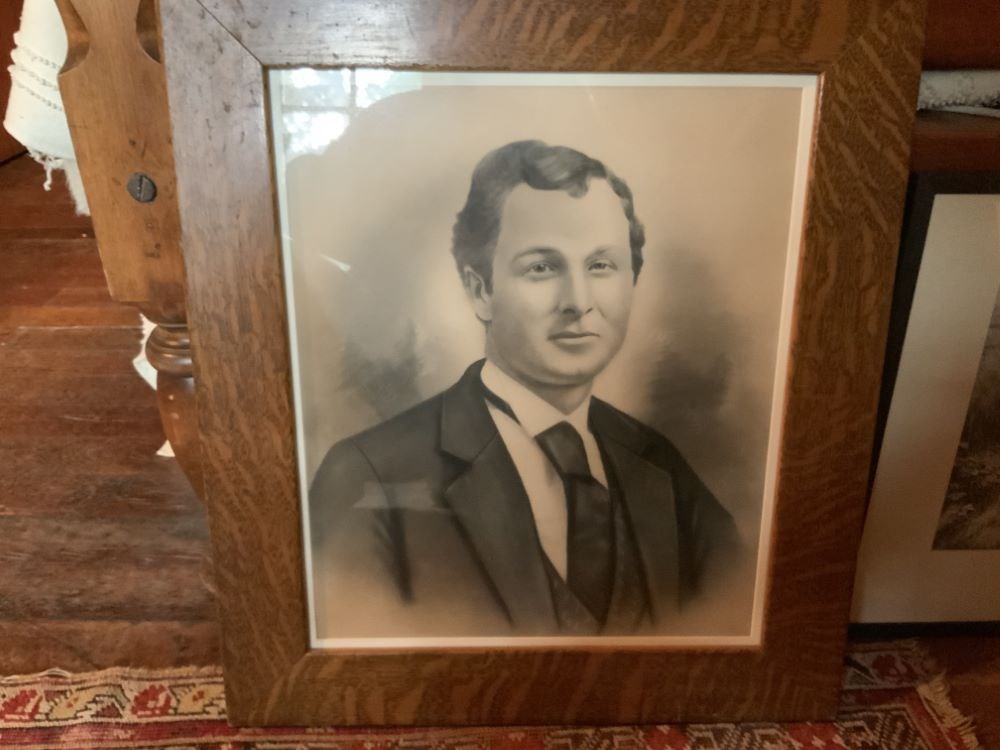
- Artist
- Unknown
- Date
- 1870 – 1875
- Medium
- charcoal; graphite on paper
- Catalogue Number
- UnK.03.01
- Description
- A head and shoulders portrait of John Brewster.
1 image
- Artist
- Unknown
- Title
- John Brewster
- Date
- 1870 – 1875
- Medium
- charcoal; graphite on paper
- Dimensions
- 47.0 x 39.0 cm
- Description
- A head and shoulders portrait of John Brewster.
- Credit
- Gift of Pearl Evelyn Moore, Banff, 1979
- Catalogue Number
- UnK.03.01
Images
This material is presented as originally created; it may contain outdated cultural descriptions and
potentially offensive content.
Read more.
- Part Of
- Murray Hay fonds
- Scope & Content
- File consists of 1 map : col., annotations, 59.9 x 41.3 cm. File pertains to an original hand-drawn map of central Montana, including annotations and a note directed to a Steve from Murray in the bottom left corner. Map details include the locations of various cities in Montana (including Butte, Bo…
- Date Range
- ca.1990-ca.1999
- Reference Code
- V795 / II / D / i / 3
- Description Level
- 5 / File
- GMD
- Drawing
- Map
- Private record
- Textual record
- Part Of
- Murray Hay fonds
- Description Level
- 5 / File
- Fonds Number
- M570 / V795
- Series
- V795 / II : Unpublished Material
- Sous-Fonds
- V795
- Sub-Series
- V795 / II / D : International / i : United States of America
- Accession Number
- 2019.41
- Reference Code
- V795 / II / D / i / 3
- Date Range
- ca.1990-ca.1999
- Physical Description
- 1 map : col., annotations ; 59.9 x 41.3 cm
- Scope & Content
- File consists of 1 map : col., annotations, 59.9 x 41.3 cm. File pertains to an original hand-drawn map of central Montana, including annotations and a note directed to a Steve from Murray in the bottom left corner. Map details include the locations of various cities in Montana (including Butte, Bozeman, Billings, Great Falls, Helena, Missoula, and Kalispell), 19 different ski hills/resorts, and mountains.
- Notes
- The Steve the map is addressed to could be Steve Cowart, who Murray Hay corresponded with in regards to other American projects (see M570 / IV / A / 1).
- Name Access
- Hay, Murray
- Subject Access
- Advertising
- Artist
- Ski Maps
- Map
- Cartography
- Sports and recreation
- Tourism
- Tourist information
- Travel
- Geography
- Winter
- Winter sports
- Ski area
- Geographic Access
- Montana
- Helena
- Great Falls
- Butte
- Bozeman
- Missoula
- United States
- Language
- English
- Conservation
- Stored flat
- Creator
- Hay, Murray
- Title Source
- Title based on contents of file
- Processing Status
- Processed
This material is presented as originally created; it may contain outdated cultural descriptions and
potentially offensive content.
Read more.
Rocky Mountaineer Geology Show
https://archives.whyte.org/en/permalink/descriptions56457
- Part Of
- Ben Gadd fonds
- Scope & Content
- File consists of 20 illustrations (13 printed, 7 hand drawn) depicting geological movements and environmental change. Images were possibly produced by Ben Gadd as part of an interpretive program or display for travel company Rocky Mountaineer.
- Date Range
- [ca.1990-2000]
- Reference Code
- M590 / III / D / 121
- Description Level
- 5 / File
- GMD
- Drawing
- Part Of
- Ben Gadd fonds
- Description Level
- 5 / File
- Fonds Number
- M590
- V810
- S61
- Series
- M590 / III : Professional records
- Sous-Fonds
- M590
- Sub-Series
- M590 / III / D : Other contracts and projects
- Accession Number
- 2021.20
- Reference Code
- M590 / III / D / 121
- GMD
- Drawing
- Responsibility
- Produced by Ben Gadd
- Date Range
- [ca.1990-2000]
- Physical Description
- 20 illustrations : 36 x 21.5 cm or smaller
- Scope & Content
- File consists of 20 illustrations (13 printed, 7 hand drawn) depicting geological movements and environmental change. Images were possibly produced by Ben Gadd as part of an interpretive program or display for travel company Rocky Mountaineer.
- Name Access
- Gadd, Ben
- Subject Access
- Landscape
- Environment
- Geographic Access
- Canada
- Alberta
- Reproduction Restrictions
- Restrictions may apply
- Language
- N/A
- Category
- Environment
- Title Source
- Original title used
- Processing Status
- Processed
This material is presented as originally created; it may contain outdated cultural descriptions and
potentially offensive content.
Read more.
Unknown Locations
https://archives.whyte.org/en/permalink/descriptions55344
- Part Of
- Murray Hay fonds
- Scope & Content
- File consists of 1 drawing : sketch, pen ; 101.5 x 60.1 cm on paper and 22 prints : col., annotations ; 44 x 40.5 cm or smaller. File pertains to an original sketch in blue ink of an unknown ski area and various prints (some annotated) of unknown ski areas and landscapes.
- Date Range
- [ca. 1980 - 2000]
- Reference Code
- V795 / II / E / 1 - 2
- Description Level
- 5 / File
- GMD
- Drawing
- Map
- Private record
- Textual record
- Part Of
- Murray Hay fonds
- Description Level
- 5 / File
- Fonds Number
- M570 / V795
- Series
- V795 / II : Unpublished Material
- Sous-Fonds
- V795
- Sub-Series
- V795 / II / E : Unknown
- Accession Number
- 2019.41
- Reference Code
- V795 / II / E / 1 - 2
- Date Range
- [ca. 1980 - 2000]
- Physical Description
- 1 drawing : sketch, pen ; 101.5 x 60.1 cm on paper
- 22 prints : col., annotations ; 44 x 40.5 cm or smaller
- Scope & Content
- File consists of 1 drawing : sketch, pen ; 101.5 x 60.1 cm on paper and 22 prints : col., annotations ; 44 x 40.5 cm or smaller. File pertains to an original sketch in blue ink of an unknown ski area and various prints (some annotated) of unknown ski areas and landscapes.
- Notes
- V795 / II / E / 1-2 may be RED Mountain Resort, Rossland BC.
- Name Access
- Hay, Murray
- Subject Access
- Advertising
- Artist
- Ski Maps
- Map
- Cartography
- Sports and recreation
- Tourism
- Tourist information
- Travel
- Geography
- Winter
- Winter sports
- Ski area
- Geographic Access
- Canada
- United States
- Language
- English
- Creator
- Hay, Murray
- Title Source
- Title based on contents of file
- Processing Status
- Processed
This material is presented as originally created; it may contain outdated cultural descriptions and
potentially offensive content.
Read more.
West Central Alberta interpretive signs
https://archives.whyte.org/en/permalink/descriptions56456
- Part Of
- Ben Gadd fonds
- Scope & Content
- File consists of one pencil outline [possibly drawn by Ben Gadd], depicting an unidentified landscape view in West Central Alberta. Drawing was used by Ben in the creation of interpretive signs.
- Date Range
- [ca.1990-1995]
- Reference Code
- M590 / III / D / 120
- Description Level
- 5 / File
- GMD
- Drawing
- Part Of
- Ben Gadd fonds
- Description Level
- 5 / File
- Fonds Number
- M590
- V810
- S61
- Series
- M590 / III : Professional records
- Sous-Fonds
- M590
- Sub-Series
- M590 / III / D : Other contracts and projects
- Accession Number
- 2021.20
- Reference Code
- M590 / III / D / 120
- GMD
- Drawing
- Responsibility
- Produced by Ben Gadd
- Date Range
- [ca.1990-1995]
- Physical Description
- 1 drawing (pencil illustration) : 43 x 18.5 cm
- Scope & Content
- File consists of one pencil outline [possibly drawn by Ben Gadd], depicting an unidentified landscape view in West Central Alberta. Drawing was used by Ben in the creation of interpretive signs.
- Name Access
- Gadd, Ben
- Subject Access
- Landscape
- Environment
- Geographic Access
- Canada
- Alberta
- Reproduction Restrictions
- Restrictions may apply
- Language
- N/A
- Related Material
- V810/III/D/PA-19 to 38
- Category
- Environment
- Title Source
- Original title used
- Processing Status
- Processed
This material is presented as originally created; it may contain outdated cultural descriptions and
potentially offensive content.
Read more.