Narrow Results By
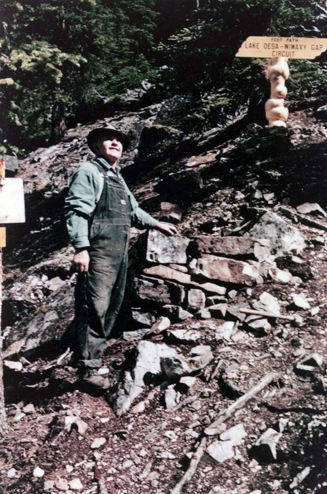
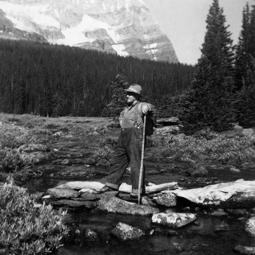
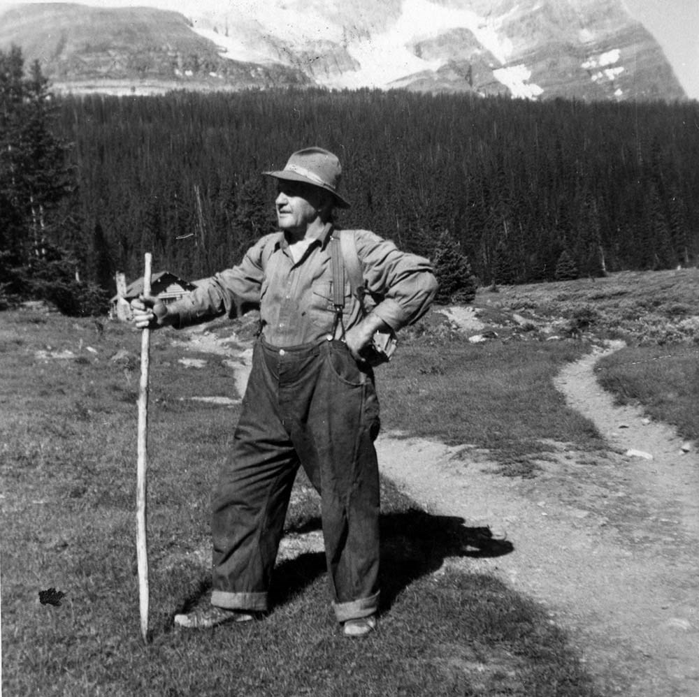
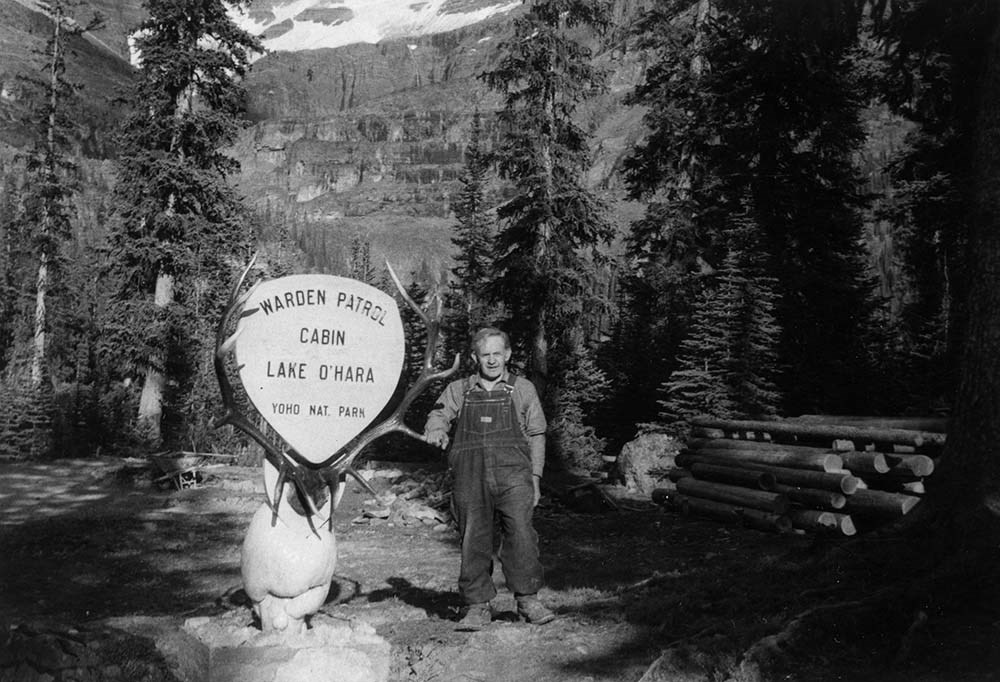
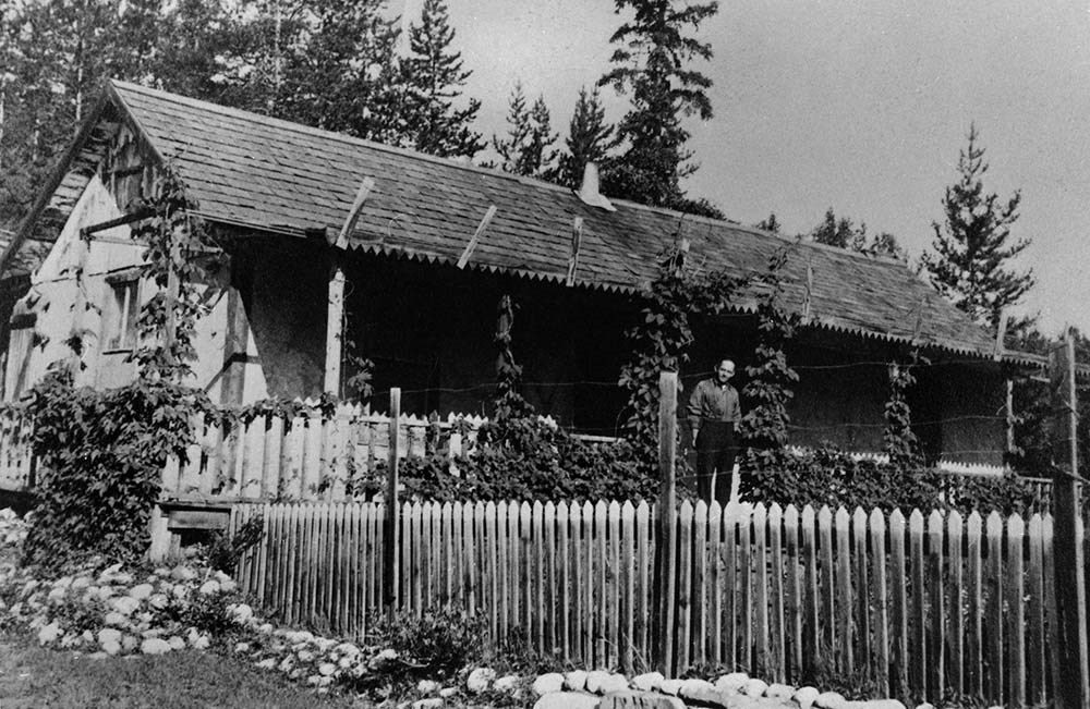
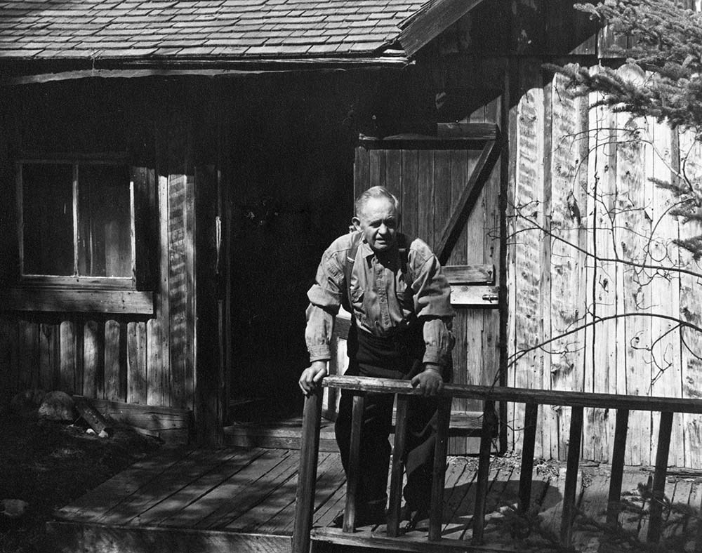
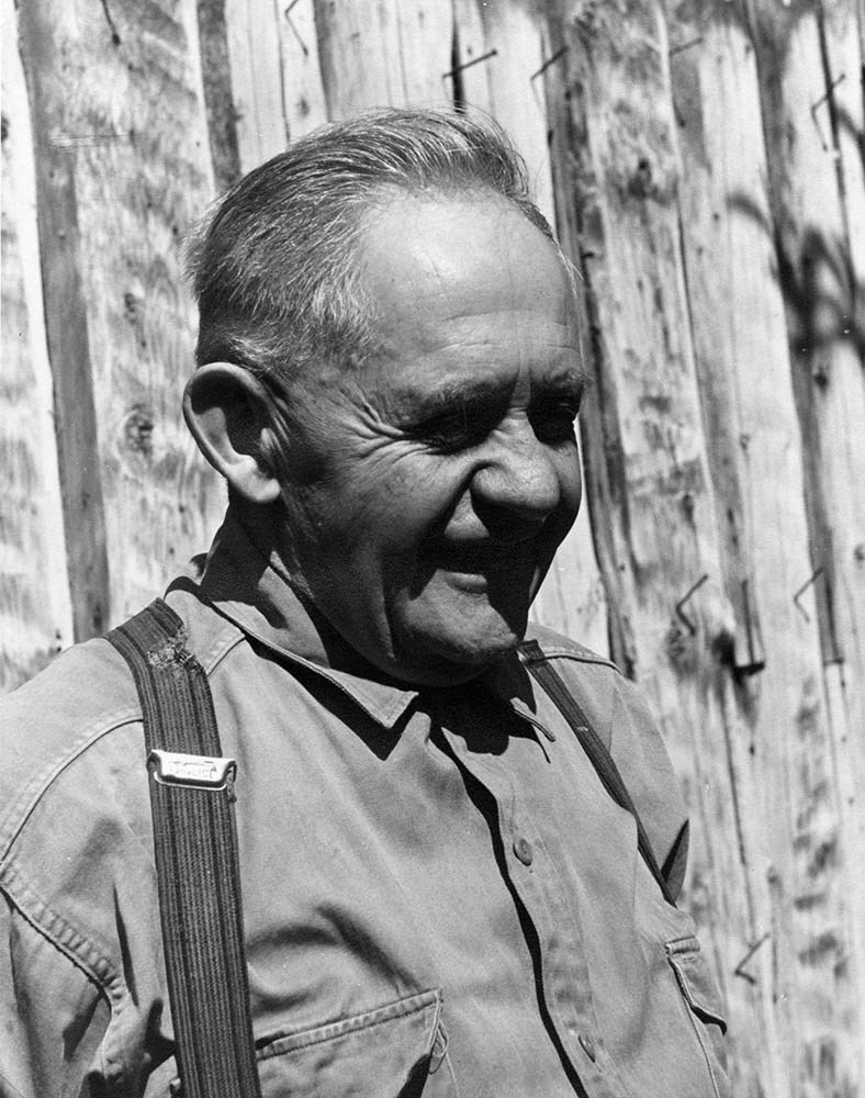
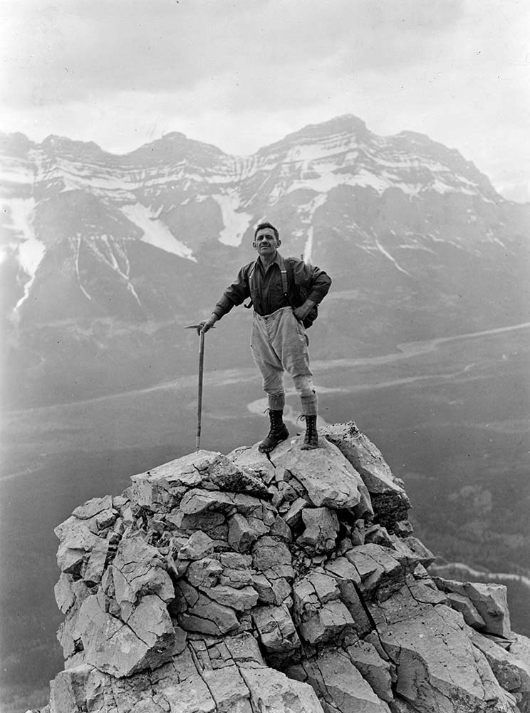
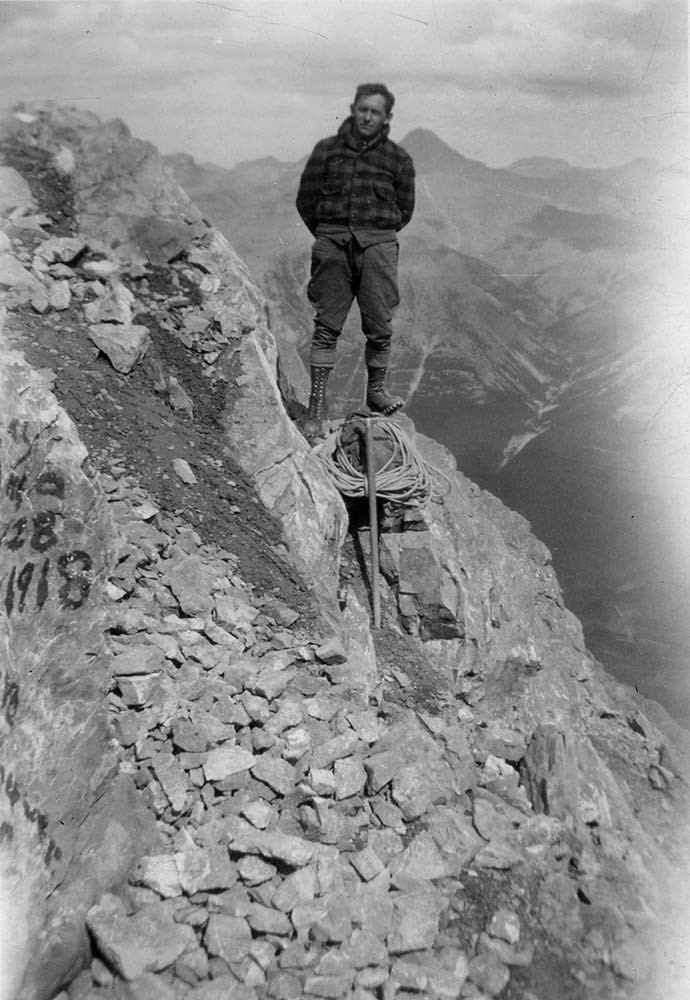
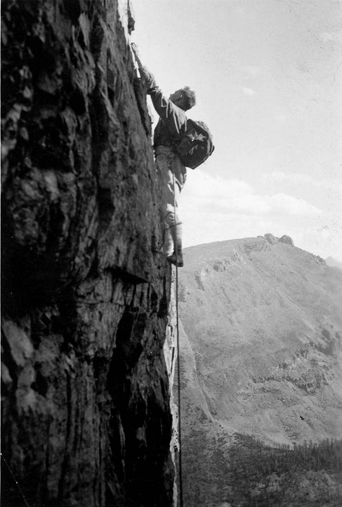
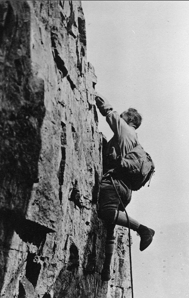
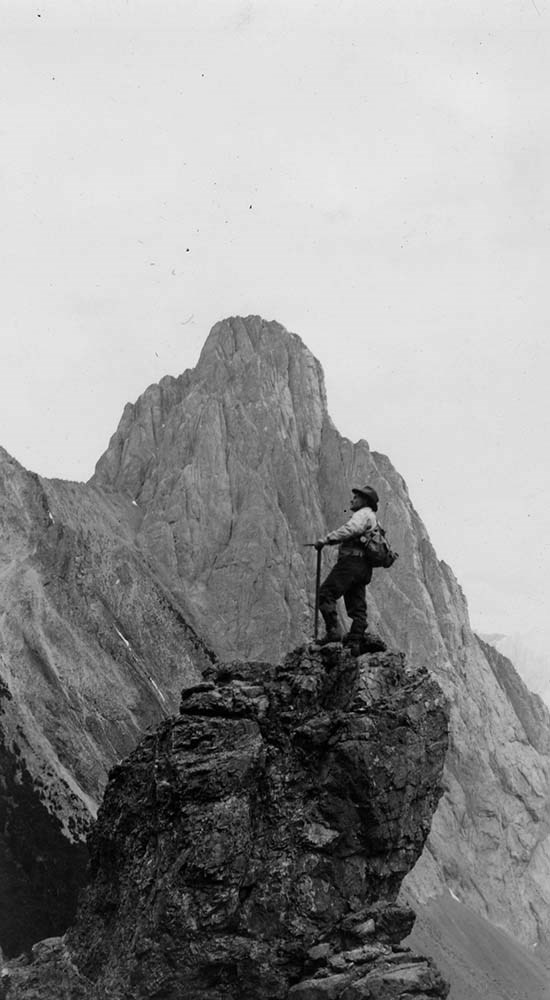
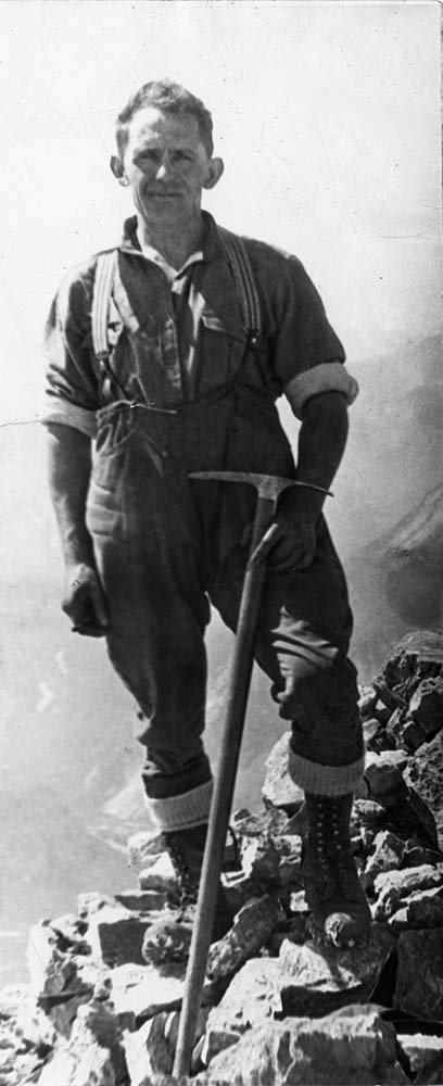
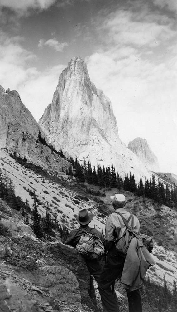
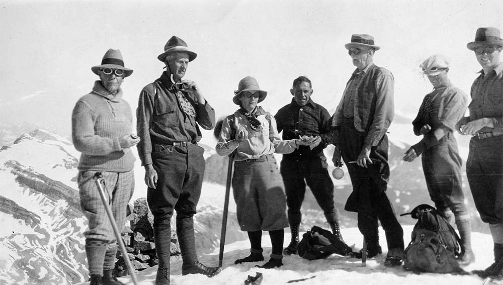
Lawrence Grassi Portraits
https://archives.whyte.org/en/permalink/descriptions3607
- Part Of
- Lawrence Grassi fonds
- Scope & Content
- File pertains to photographs of Lawrence Grassi; includes Grassi climbing, at leisure and posed views.
- Date Range
- [ca. 1950-1980]
- Reference Code
- V240 / II / B / PA - 625 to 671
- Description Level
- 5 / File
- GMD
- Photograph
- Photograph print
19 images
- Part Of
- Lawrence Grassi fonds
- Description Level
- 5 / File
- Fonds Number
- M45 / V240
- Series
- II.B. Personal photographs
- Sous-Fonds
- V240
- Accession Number
- .
- Reference Code
- V240 / II / B / PA - 625 to 671
- Date Range
- [ca. 1950-1980]
- Physical Description
- 52 photographs : prints, b&w, colour
- History / Biographical
- See fonds level description
- Scope & Content
- File pertains to photographs of Lawrence Grassi; includes Grassi climbing, at leisure and posed views.
- Name Access
- Grassi, Lawrence
- Subject Access
- Activities
- Climbing
- Family and personal life
- Home
- Mountains
- Photography
- Portrait
- Geographic Access
- Rocky Mountains
- Lake O'Hara
- Canmore
- Yoho National Park
- Alberta
- British Columbia
- Canada
- Access Restrictions
- Access to negatives is by appointment only
- Language
- NA
- Title Source
- Title based on contents of file
- Processing Status
- Processed
Images


This material is presented as originally created; it may contain outdated cultural descriptions and
potentially offensive content.
Read more.
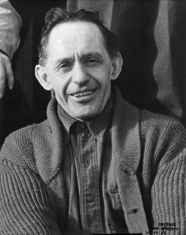
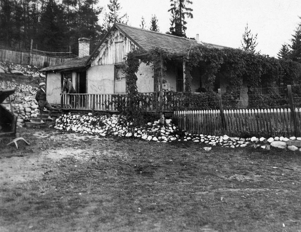
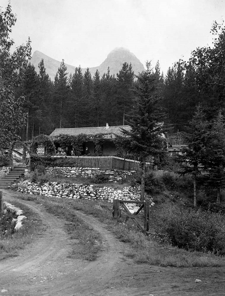
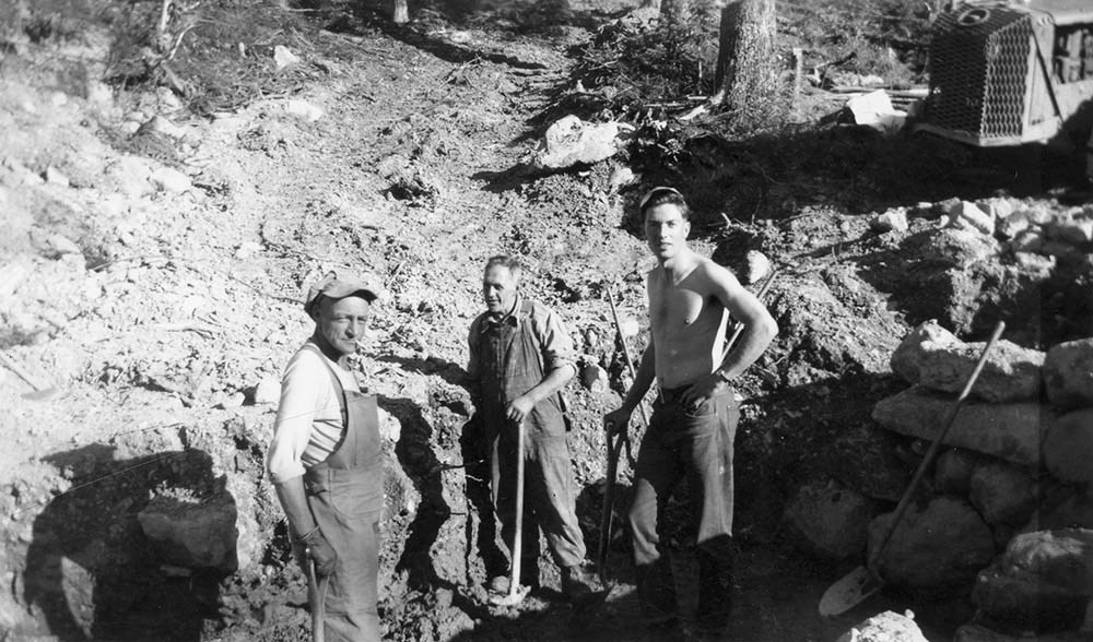
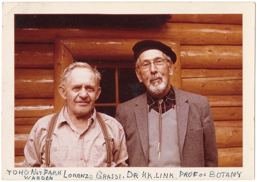
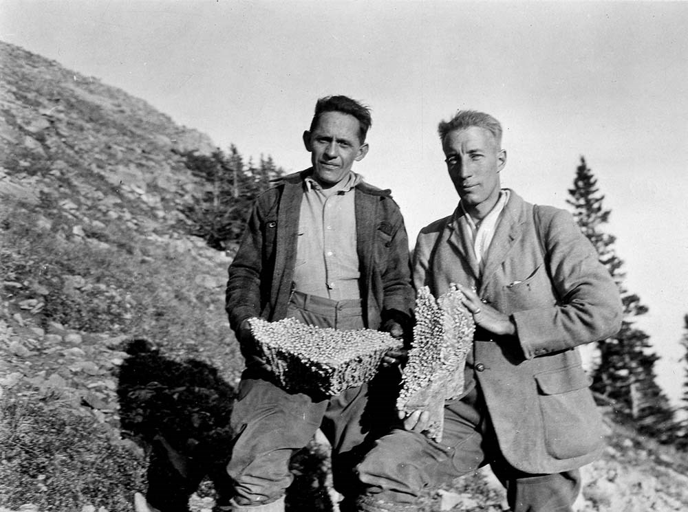
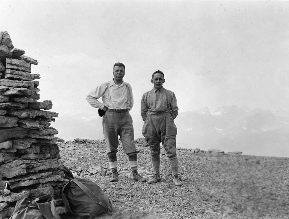
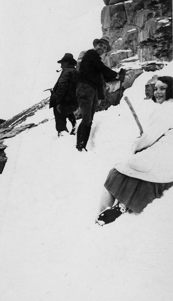
Lawrence Grassi With Others
https://archives.whyte.org/en/permalink/descriptions3608
- Part Of
- Lawrence Grassi fonds
- Scope & Content
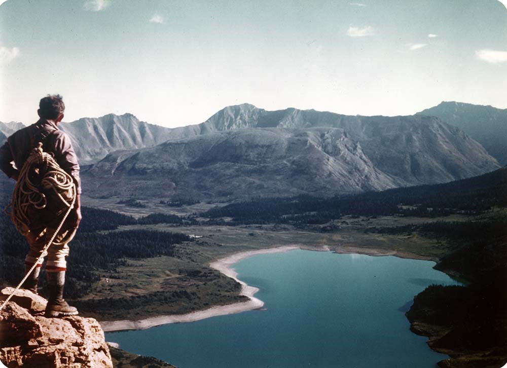
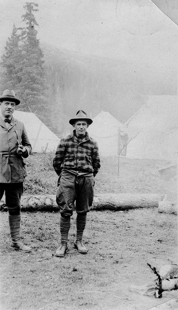
- File pertains to photographs of Lawrence Grassi with others, many are unidentified; includes climbing, leisure and posed views. Also includes of Grassi at his home in Canmore.
- Date Range
- [ca. 1930-1980]
- Reference Code
- V240 / II / B / PA - 672 to 731
- Description Level
- 5 / File
- GMD
- Photograph
- Photograph print
13 images
- Part Of
- Lawrence Grassi fonds
- Description Level
- 5 / File
- Fonds Number
- M45 / V240
- Series
- II.B. Personal photographs
- Sous-Fonds
- V240
- Accession Number
- .
- Reference Code
- V240 / II / B / PA - 672 to 731
- Date Range
- [ca. 1930-1980]
- Physical Description
- 61 photographs : prints, b&w colour
- History / Biographical
- See fonds level description
- Scope & Content
- File pertains to photographs of Lawrence Grassi with others, many are unidentified; includes climbing, leisure and posed views. Also includes of Grassi at his home in Canmore.
- Subject Access
- Activities
- Climbing
- Family and personal life
- Guide
- Guiding
- Home
- Lake O'Hara region
- Mountains
- Portrait
- Professional and Personal Life
- Scenery
- Geographic Access
- Lake O'Hara
- Canmore
- Rocky Mountains
- Yoho National Park
- Alberta
- British Columbia
- Canada
- Access Restrictions
- Access to negatives is by appointment only
- Language
- English
- Title Source
- Title based on contents of file
- Processing Status
- Processed
Images


This material is presented as originally created; it may contain outdated cultural descriptions and
potentially offensive content.
Read more.
Maps of Banff and Western Canada
https://archives.whyte.org/en/permalink/descriptions54772
- Part Of
- Luxton family fonds
- Scope & Content
- File consists of 9 printed maps, b&w and col. [including zoning and topographical maps] depicting the Town of Banff and Banff National Park, the Rocky Mountains Forest Reserve, the Moose Mountain region, Medicine Hat, and the province of Alberta. File includes Trail Riders' Map of the Canadian Rock…
- Date Range
- 1912
- 1914
- 1924
- 1926
- 1932
- 1957
- [1970-1980]
- Reference Code
- LUX / II / C5 / 25
- Description Level
- 5 / File
- GMD
- Textual record
- Published record
- Map
- Part Of
- Luxton family fonds
- Description Level
- 5 / File
- Fonds Number
- LUX
- Series
- LUX / II / C : Personal
- Sous-Fonds
- LUX / II : Eleanor Luxton sous-fonds
- Sub-Series
- LUX / II / C5 : Other
- Accession Number
- LUX
- Reference Code
- LUX / II / C5 / 25
- Date Range
- 1912
- 1914
- 1924
- 1926
- 1932
- 1957
- [1970-1980]
- Physical Description
- 9 maps : b&w and col. ; 168 x 71 cm or smaller
- Scope & Content
- File consists of 9 printed maps, b&w and col. [including zoning and topographical maps] depicting the Town of Banff and Banff National Park, the Rocky Mountains Forest Reserve, the Moose Mountain region, Medicine Hat, and the province of Alberta. File includes Trail Riders' Map of the Canadian Rockies which has smaller maps of Waterton Lakes, Glacier, Revelstoke, and other national parks printed on the back. Map of Medicine Hat includes annotated storage envelope with dimensions written on the front.
- Subject Access
- Cartography
- Geography
- Land use
- Government
- Travel
- National parks and reserves
- Geographic Access
- Canada
- Alberta
- Banff
- Banff National Park
- Medicine Hat
- Rocky Mountains
- Glacier National Park
- Revelstoke
- Waterton Lakes National Park
- Reproduction Restrictions
- Restrictions may apply
- Language
- English
- Title Source
- Title based on contents of file
- Processing Status
- Processed
This material is presented as originally created; it may contain outdated cultural descriptions and
potentially offensive content.
Read more.
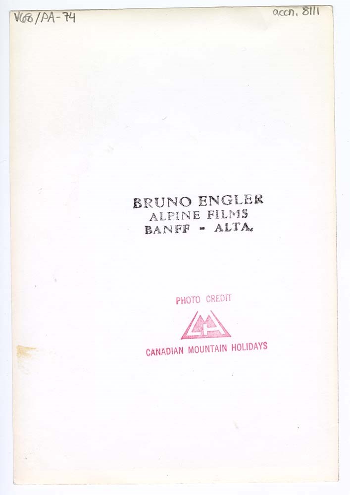
Misc. Personal and Professional Photographs
https://archives.whyte.org/en/permalink/descriptions22905
- Part Of
- Hans Gmoser fonds
- Scope & Content
- File pertains to various professional and personal photographs of or by Hans Gmoser.
- Date Range
- 1957-1969
- Reference Code
- V68 / V / PA 3 - 39 to 91
- Description Level
- 5 / File
- GMD
- Photograph
4 images
- Part Of
- Hans Gmoser fonds
- Description Level
- 5 / File
- Fonds Number
- M224 / S49 / V68
- Series
- V. Photograph Prints
- Sous-Fonds
- V68
- Accession Number
- 8111
- Reference Code
- V68 / V / PA 3 - 39 to 91
- GMD
- Photograph
- Date Range
- 1957-1969
- Physical Description
- 52 photographs: prints, b&w; col.
- History / Biographical
- See fonds level description
- Scope & Content
- File pertains to various professional and personal photographs of or by Hans Gmoser.
- Notes
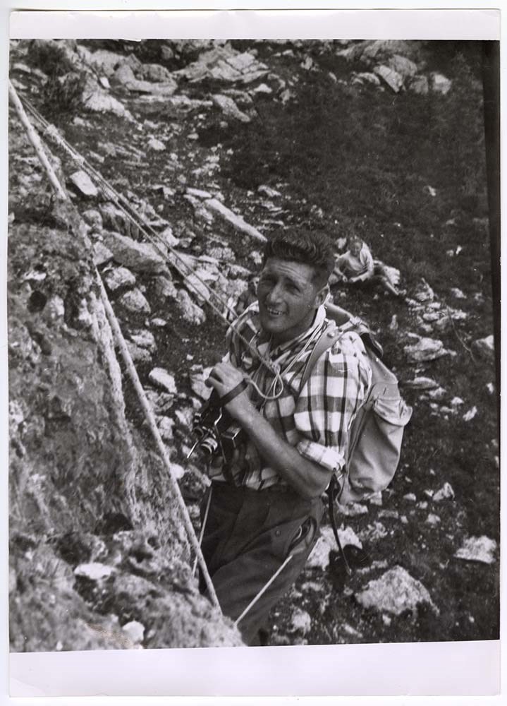
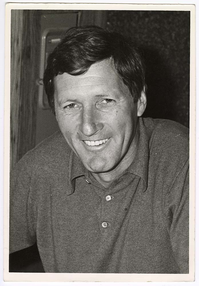
- Captured from exterior folder: "Main folder 6". Contained within that folder was another folder with the notation: “Double LL Colour (Building)”. IMAGES : 39. [Photograph of building in snow with wood siding], n.d., 9 x 9 cm, colour. 40. “K”, [Young man standing, hands behind back, in front of brick wall], n.d., 6.5 x 9.75 cm, black and white, textured edges. 41. “Hans Gmoser and Grandfather Hans Ranetbauer”, [Young Hans on back of motorcycle with grandfather at front], n.d., 9 x 6.5 cm, black and white, caption written in pencil, with black paper and glue on back. 42. “Krippenstein Keillarmun [? Illegible], [Middle aged man standing on a rock wall with a flag and a mountain peak in back], 3.8.8.1959, 9 x 6.5 cm, black and white, caption written in blue ink, textured edges. 43. “Die gololn’e Misterin [?] Traun, 25.1. 1952”, [Group of people on a stage in costume], 14 x 9.75 cm, black and white, back is postcard style, with lines and caption written in blue ink. 44. “5”, [Man laughing with hands in pockets outside of house], n.d., 13 x 8.5 cm, black and white, textured edges. 45. [Group of eight people standing in a yard with mesh fence and house in background], n.d., 7 x 5.5 cm, black and white, textured edges. [Similar images see V68/PA 45, 52, 55, 56, 72] 46. [Family portrait: Ten people of varying ages], n.d., 20 x 13 cm, black and white, matt finish. 47. “Filming Little Yoho 1957” [Man (Hans?) with camera and climbing equipment], 13 x 18 cm, black and white. 48. “Hans Gmoser C44551 3”, [Hans walking down a city street, with one hand in pocket], n.d., 8 x 11.5 cm, black and white, matt finish. 49. “14” [Group of men and women standing against a road barrier on a cobblestone road, with house to right], n.d., 6.5 x 7.75 cm, black and white, textured edges. 50. “Ein Bleines Andenken von Deiner Schwester Annemarie im August 1957”, [Professional portrait of a woman, with a lace collar], 5 x 7 cm, black and white, caption written in blue pen, matt finish. 51. [Caption illegible, Man and woman leaning on/climbing rock], 3-8.8.1959, 7.75 x 9.25 cm, black and white, caption written in blue ink. 52. [Group of eight people standing in a yard with mesh fence and house in background], n.d., 7 x 5.5 cm, black and white, textured edges. [Similar images see V68/PA 45, 52, 55, 56, 72] 53. “Mt. Assiniboine Hans Gmoser”, [Hans with cane, log and mountain in back], n.d., 6.5 x 9 cm, black and white, caption written in pencil. 54. [Three men and a boy eating at a kitchen table], n.d., 8.25 x 8.25 cm, black and white. [see V68/PA 59, 60 for dup] 55. [Two men and two women standing in a parking lot, car to left, tree to right], n.d., 10.25 x 7.25 cm, black and white. [Similar images see V68/PA 45, 52, 55, 56, 72] 56. [Three men and a woman standing in a parking lot, car to left, tree to right], n.d., 10.25 x 7.25 cm, black and white. [Similar images see V68/PA 45, 52, 55, 56, 72] 57. “Bugaboos 1968 below Marmolata Ray Conkling Pete Wingle Bill Rosenfeld 4/68”, [Two men in foreground, left with skis right with camera, man at top right climbing up snowdrift], April 1968, 11 x 11 cm, colour, “Gmoser” written on bottom back left corner, “APR 68” printed on front right side, captions written in pencil and pen. 58. “Mt. Assiniboine Hans Gmoser”, [Hans sitting with logs surrounding, mountain in back], n.d., 6.5 x 9 cm, black and white, caption written in pencil. 59. [Three men and a boy eating at a kitchen table], n.d., 8.25 x 8.25 cm, black and white, bottom left corner bent. [see V68/PA 54, 60 for dup] 60. [Three men and a boy eating at a kitchen table], n.d., 8.25 x 8.25 cm, black and white. [see V68/PA54, 59 for dup] 61. “25” [Older woman with white collar and man with hat sitting on bench, in grass with crumbling brick behind], n.d., 6.25 x 6.5 cm, black and white, textured edges. 62. [Woman and man wearing white knee socks with clasped arms walking with trees in background], n.d., 6 x 9.25 cm, black and white, textured edges, matt finish. 63. [Two women, two men, and a boy in front of greenery and picket fence], n.d., 6.5 x 6.5 cm, black and white, background overexposed, back glued, ripped black paper. 64. “4sh [?]” [Young boy in uniform], n.d., 5.25 x 7 cm, black and white, textured edges, matt finish. 65. “Unser Herim in Ozmunting [?]”, [Five adults standing in front of mesh fence and house in background], n.d., 9 x 6.5 cm, black and white, textured edges. 66. “10 month Conrad Gmoser Bugaboos 1969”, [Young boy holding baby Conrad on sled, with trees and mountains in back], March 1969, 9 x 9 cm, black and white, “MAR 69 written on front right side, “Gmoser” written in bottom left corner. 67. “4” [Man and woman laughing, leaning on ping pong table outside, with house in back], n.d., 6 x 8 cm, black and white, textured edges. 68. [Professional photograph in studio of man, in suit with landscape in background], n.d., 9 x 14 cm, black and white, heavier paper, lines for postcard on back, corner edges worn. 69. “Spilemauer Ostwand Hans Reischl”, [Mountain in background, with trees and snow in foreground], n.d., 9 x 14 cm, black and white, writing inscribed into support on front, heavier paper, lines for postcard on back, textured edges. 70. [Mountain in background, shrubbery heavy with snow in foreground], n.d., 14 x 9 cm, black and white, heavier paper, lines for postcard on back, textured edges, stain on bottom left. 71. [Man standing in dirt yard with two houses in background], n.d., 5.5 x 7 cm, black and white, textured edges. 72. [Group of eight people standing in a yard with mesh fence and house in background], n.d., 7 x 5.5 cm, black and white, textured edges. [Similar images see V68/PA 45, 52, 55, 56, 72] 73. “Derek Ellis Heli Pilot Bugaboo 1971”, Photograph by Bruno Engler, copyright, [Two men by Bullock helicopter with oil drums in foreground, ATV to left side, mountain in back], 25 x 20.25 cm, black and white, matt finish. 74. [Portrait of Hans Gmoser] stamped “Bruno Engler Alpine Films Banff- ALTA. Photo credit Canadian Mountain Holidays,” n.d., 12.7 x 17.8 cm, black and white. 75. [Portrait of Hans Gmoser], n.d., 12.7 x 17.8 cm, black and white, light surfaces scratches and dirt on left side. 76. “Tunnel Mountain- Gonda Traverse 1971”, [Close up of Hans with tousled hair, furrowed brow and climbing gear], 1971, 8.25 x 11.5 cm, black and white, 12 copies, first copy with caption on back in pencil, stored in small envelope “Use this envelope to order.” 77. “Tunnel Mountain- Gonda Traverse 1971”, [Close up of Hans with tousled hair, furrowed brow and climbing gear], 1971, 8.25 x 11.5 cm, black and white, 12 copies, first copy with caption on back in pencil, stored in small envelope “Use this envelope to order.” 78. “Tunnel Mountain- Gonda Traverse 1971”, [Close up of Hans with tousled hair, furrowed brow and climbing gear], 1971, 8.25 x 11.5 cm, black and white, 12 copies, first copy with caption on back in pencil, stored in small envelope “Use this envelope to order.” 79. “Tunnel Mountain- Gonda Traverse 1971”, [Close up of Hans with tousled hair, furrowed brow and climbing gear], 1971, 8.25 x 11.5 cm, black and white, 12 copies, first copy with caption on back in pencil, stored in small envelope “Use this envelope to order.” 80. “Tunnel Mountain- Gonda Traverse 1971”, [Close up of Hans with tousled hair, furrowed brow and climbing gear], 1971, 8.25 x 11.5 cm, black and white, 12 copies, first copy with caption on back in pencil, stored in small envelope “Use this envelope to order.” 81. “Tunnel Mountain- Gonda Traverse 1971”, [Close up of Hans with tousled hair, furrowed brow and climbing gear], 1971, 8.25 x 11.5 cm, black and white, 12 copies, first copy with caption on back in pencil, stored in small envelope “Use this envelope to order.” 82. “Tunnel Mountain- Gonda Traverse 1971”, [Close up of Hans with tousled hair, furrowed brow and climbing gear], 1971, 8.25 x 11.5 cm, black and white, 12 copies, first copy with caption on back in pencil, stored in small envelope “Use this envelope to order.” 83. “Tunnel Mountain- Gonda Traverse 1971”, [Close up of Hans with tousled hair, furrowed brow and climbing gear], 1971, 8.25 x 11.5 cm, black and white, 12 copies, first copy with caption on back in pencil, stored in small envelope “Use this envelope to order.” 84. “Tunnel Mountain- Gonda Traverse 1971”, [Close up of Hans with tousled hair, furrowed brow and climbing gear], 1971, 8.25 x 11.5 cm, black and white, 12 copies, first copy with caption on back in pencil, stored in small envelope “Use this envelope to order.” 85. “Tunnel Mountain- Gonda Traverse 1971”, [Close up of Hans with tousled hair, furrowed brow and climbing gear], 1971, 8.25 x 11.5 cm, black and white, 12 copies, first copy with caption on back in pencil, stored in small envelope “Use this envelope to order.” 86. “Tunnel Mountain- Gonda Traverse 1971”, [Close up of Hans with tousled hair, furrowed brow and climbing gear], 1971, 8.25 x 11.5 cm, black and white, 12 copies, first copy with caption on back in pencil, stored in small envelope “Use this envelope to order.” 87. “Tunnel Mountain- Gonda Traverse 1971”, [Close up of Hans with tousled hair, furrowed brow and climbing gear], 1971, 8.25 x 11.5 cm, black and white, 12 copies, first copy with caption on back in pencil, stored in small envelope “Use this envelope to order.” 88. [Middle aged man standing in park with hands in pocket], n.d., 5 x 7 cm, black and white, textured edges. 89. “Summit of Excellence Award- Mt. Film Festival ’89 c John Amatt”, [Gmoser receiving the award on stage from Amatt], 1989, 20.25 x 26 cm, black and white. 90. [Contact sheet with professional shots of Gmoser], n.d., 20.25 x 26 cm, colour, contacts numbered in yellow pen, not sequentially 3-16, 10 in total, matt finish. 91. “Boulder Camp Cook Margaret Gmoser 1966,” [Margaret walking away from tent, with rocks in back], 1966, 20.25 x 26 cm, black and white.
- Name Access
- Gmoser, Hans
- Subject Access
- Activities
- Discovery and exploration
- Climbing
- Backcountry skiing
- Buildings
- Environment and Nature
- Exploration
- Family and personal life
- Mountains
- Mountaineering
- Portrait
- Photography
- Professional and Personal Life
- Scenery
- Sports and recreation
- Skiing
- Ski areas
- Geographic Access
- Rocky Mountains
- Selkirks
- Alberta
- British Columbia
- Canada
- Language
- English
- Title Source
- Title based on contents of file
- Processing Status
- Processed
Images
This material is presented as originally created; it may contain outdated cultural descriptions and
potentially offensive content.
Read more.
- Part Of
- Alpine Club of Canada fonds
- Scope & Content
- File consists of summit records from Monarch Mountain produced by the Alpine Club of Canada between 1940 and 1979. Summit records include entries from visitors to the various summits which pertain to individuals' hiking and climbing trips; details of specific events which occurred while at the summ…
- Date Range
- 1940
- 1943
- 1960
- 1962-1979
- Reference Code
- M200 / V / A / 153
- Description Level
- 5 / File
- GMD
- Textual record
- Organization record
- Part Of
- Alpine Club of Canada fonds
- Description Level
- 5 / File
- Fonds Number
- M200
- V14
- S6
- Series
- M200 / V: Summit Records
- Sous-Fonds
- M200
- Sub-Series
- M200 / V / A: Identified Summit Records
- Accession Number
- accn. 2023.18
- Reference Code
- M200 / V / A / 153
- Responsibility
- Summit Registers and Notes produced by Alpine Club of Canada
- Date Range
- 1940
- 1943
- 1960
- 1962-1979
- Physical Description
- 1 cm of textual records 4 volumes
- History / Biographical
- Monarch Mountain is located in the Victoria Cross Ranges of Jasper National Park, Alberta. Nearby are Pyramid Mountain and Jasper town-site.
- Scope & Content
- File consists of summit records from Monarch Mountain produced by the Alpine Club of Canada between 1940 and 1979. Summit records include entries from visitors to the various summits which pertain to individuals' hiking and climbing trips; details of specific events which occurred while at the summit, wildlife sightings, trail updates, and related topics. File include: M200 / V / A / 153: Monarch Mtn
- Notes
- Materials came together in a plastic bag with a note "Monarch Mtn". Summit Register is believed to be from White Pyramid; materials have been kept together due to orginial order they were received from the Alpine Club of Canada.
- Name Access
- Alpine Club of Canada
- Subject Access
- Alberta
- Alpine Club of Canada
- Backpacking
- Backcountry skiing
- Climbing
- Club
- Description and travel
- Environment
- Environment and Nature
- Hiking
- Mountain
- Mountaineering
- Mountaineers
- Mountains
- National parks and reserves
- Record keeping
- Sports and leisure
- Sports and recreation
- Summit
- Geographic Access
- Canada
- Canadian Rocky Mountains
- Rocky Mountains
- Alberta
- Jasper National Park
- Jasper
- Jasper, AB
- Victoria Cross Range
- Monarch Mountain
- Access Restrictions
- Restrictions may apply
- Language
- English
- Conservation
- Summit notes placed in mylar due to mold and fragility. Summit register contains mold and water damage.
- Related Material
- M235
- M200 / V / A / 130
- Biographical Source Notes
- Peak Finder: Monarch Mountain, Canadian Rockies Database: https://cdnrockiesdatabases.ca/peaks/922
- Title Source
- Original title
- Processing Status
- Processed
This material is presented as originally created; it may contain outdated cultural descriptions and
potentially offensive content.
Read more.
Mount Aylmer Summit Records
https://archives.whyte.org/en/permalink/descriptions57739
- Part Of
- Alpine Club of Canada fonds
- Scope & Content
- Files consist of summit notes and summit registers from Mount Aylmer produced by the Alpine Club of Canada between 1988 and 2005. Summit records include entries from visitors to the various summits which pertain to individuals' hiking and climbing trips; details of specific events which occurred wh…
- Date Range
- 1988-2005
- Reference Code
- M200 / V / A / 151 to 152
- Description Level
- 5 / File
- GMD
- Textual record
- Organization record
- Part Of
- Alpine Club of Canada fonds
- Description Level
- 5 / File
- Fonds Number
- M200
- V14
- S6
- Series
- M200 / V: Summit Records
- Sous-Fonds
- M200
- Sub-Series
- M200 / V / A: Identified Summit Records
- Accession Number
- accn. 2023.10
- accn. 7779
- Reference Code
- M200 / V / A / 151 to 152
- Responsibility
- Summit Registers and Notes produced by Alpine Club of Canada
- Date Range
- 1988-2005
- Physical Description
- 2 cm of textual records 2 volumes
- History / Biographical
- Mount Aylmer is located in Banff National Park, Alberta, and is part of the Palliser Range of the Canadian Rockies. Nearby are Banff and Canmore.
- Scope & Content
- Files consist of summit notes and summit registers from Mount Aylmer produced by the Alpine Club of Canada between 1988 and 2005. Summit records include entries from visitors to the various summits which pertain to individuals' hiking and climbing trips; details of specific events which occurred while at the summit, wildlife sightings, trail updates, and related topics. Files include: M200 / V / A / 151: Mount Aylmer summit register July 29, 1988 - Aug. 25, 1995 via ACC office Feb. 1998 M200 / V / A / 152: Mt. Aylmer Sept. 4, 1995 - Aug 20, 2005
- Name Access
- Alpine Club of Canada
- Subject Access
- Alberta
- Alpine Club of Canada
- Backpacking
- Banff
- Banff National Park
- Climbing
- Club
- Description and travel
- Environment
- Environment and Nature
- Hiking
- Mountain
- Mountaineering
- Mountaineers
- Mountains
- National parks and reserves
- Parks
- Record keeping
- Ski mountaineering
- Sports and leisure
- Sports and recreation
- Summit
- Trails
- Geographic Access
- Canada
- Canadian Rocky Mountains
- Rocky Mountains
- Alberta
- Banff National Park
- Banff, AB
- Banff, Alberta
- Canmore
- Canmore, AB
- Canmore, Alberta
- Palliser Range
- Mount Aylmer
- Access Restrictions
- Restrictions may apply
- Language
- English
- French
- Related Material
- M235
- Title Source
- Original title
- Processing Status
- Processed
This material is presented as originally created; it may contain outdated cultural descriptions and
potentially offensive content.
Read more.
Mount Edith Summit Records
https://archives.whyte.org/en/permalink/descriptions57695
- Part Of
- Alpine Club of Canada fonds
- Scope & Content
- Files consist of summit notes and summit registers from Mount Edith (in Banff National Park), produced by the Alpine Club of Canada between around 1987 and 2015. Summit records include entries from visitors to the various summits which pertain to individuals' hiking and climbing trips; details of s…
- Date Range
- ca.1987-2005
- 2007-2015
- Reference Code
- M200 / V / A / 101 to 105
- Description Level
- 5 / File
- GMD
- Textual record
- Organization record
- Part Of
- Alpine Club of Canada fonds
- Description Level
- 5 / File
- Fonds Number
- M200
- V14
- S6
- Series
- M200 / V: Summit Records
- Sous-Fonds
- M200
- Sub-Series
- M200 / V / A: Identified Summit Records
- Accession Number
- accn. 2023.10
- accn. 7779
- accn. 2023.19
- Reference Code
- M200 / V / A / 101 to 105
- Responsibility
- Summit Registers and Notes produced by Alpine Club of Canada
- Date Range
- ca.1987-2005
- 2007-2015
- Physical Description
- 5 volumes 8 cm of textual records
- History / Biographical
- Mount Edith is located in the Bow Valley of Banff National Park, AB, and is along the Sawback Range. It was named for Edith Orde who worked as an assistant to Lady Agnes Macdonald.
- Scope & Content
- Files consist of summit notes and summit registers from Mount Edith (in Banff National Park), produced by the Alpine Club of Canada between around 1987 and 2015. Summit records include entries from visitors to the various summits which pertain to individuals' hiking and climbing trips; details of specific events which occurred while at the summit, wildlife sightings, trail updates, and related topics. Files include: M200 / V / A / 101: Mount Edith North Summit Summit register Aug. 5, 1993 - June 17, 1995 M200 / V / A / 102: [Mt. Edith? 1997 - 2001] M200 / V / A / 103: [Summit Notes and Mt. Edith Summit Register. ca. 1987 - 2005] M200 / V / A / 104: Mt. Edith summit register July 16, 1995 - July 12, 1998 M200 / V / A / 105: Mount Edith notebook filled [2007-2015]
- Name Access
- Alpine Club of Canada
- Subject Access
- Alberta
- Alpine Club of Canada
- Backcountry skiing
- Backpacking
- Banff
- Banff National Park
- Bow Valley
- Climbing
- Club
- Cross-country skiing
- Description and travel
- Environment
- Environment and Nature
- Hiking
- Mountain
- Mountaineering
- Mountaineers
- Mountains
- National parks and reserves
- Parks
- Record keeping
- Ski areas
- Ski area
- Skiing
- Skiers
- Ski mountaineering
- Sports and leisure
- Sports and recreation
- Summit
- Trails
- Winter sports
- Geographic Access
- Canada
- Alberta
- Canadian Rocky Mountains
- Rocky Mountains
- Banff National Park
- Banff
- Access Restrictions
- Restrictions may apply
- Language
- English
- French
- German
- Conservation
- Some registers contain evidence of mold.
- Related Material
- M235
- Biographical Source Notes
- Peak Finder: Mount Edith, Canadian Rockies Database: https://cdnrockiesdatabases.ca/peaks/414
- Title Source
- Title based on contents of file
- Processing Status
- Processed
This material is presented as originally created; it may contain outdated cultural descriptions and
potentially offensive content.
Read more.
Mount Fisher Summit Register, 2005-2009
https://archives.whyte.org/en/permalink/descriptions57798
- Part Of
- Alpine Club of Canada fonds
- Scope & Content
- File consists of a summit record from Mount Fisher produced by the Alpine Club of Canada between 2005 and 2009. Summit record includes entries from visitors to the various summits which pertain to individuals' hiking and climbing trips; details of specific events which occurred while at the summit,…
- Date Range
- 2005-2009
- Reference Code
- M200 / V / A / 217
- Description Level
- 5 / File
- GMD
- Textual record
- Organization record
- Part Of
- Alpine Club of Canada fonds
- Description Level
- 5 / File
- Fonds Number
- M200
- V14
- S6
- Series
- M200 / V: Summit Records
- Sous-Fonds
- M200
- Sub-Series
- M200 / V / A: Identified Summit Records
- Accession Number
- accn. 2014.8316
- Reference Code
- M200 / V / A / 217
- Responsibility
- Summit Registers and Notes produced by Alpine Club of Canada
- Date Range
- 2005-2009
- Physical Description
- 1 volume 2 cm of textual records
- History / Biographical
- Mount Fisher, also known as Fisher Peak, is part of the Hughes Range of the Canadian Rockies in southeastern British Columbia. Nearby are Cranbrook, Fort Steele, and Mount Morro.
- Scope & Content
- File consists of a summit record from Mount Fisher produced by the Alpine Club of Canada between 2005 and 2009. Summit record includes entries from visitors to the various summits which pertain to individuals' hiking and climbing trips; details of specific events which occurred while at the summit, wildlife sightings, trail updates, and related topics. File: M200 / V / A / 217: Mount Fisher Summit Register, 2005-2009
- Name Access
- Alpine Club of Canada
- Subject Access
- Alpine Club of Canada
- Backpacking
- British Columbia
- Climbing
- Club
- Description and travel
- Environment
- Environment and Nature
- Hiking
- Mountain
- Mountaineering
- Mountaineers
- Mountains
- Record keeping
- Sports and leisure
- Sports and recreation
- Summit
- Trails
- Geographic Access
- Canada
- Canadian Rocky Mountains
- Rocky Mountains
- Hughes Range
- British Columbia
- Cranbrook, BC
- Cranbrook
- Cranbrook, British Columbia
- Fort Steele
- Mount Morro
- Mount Fisher
- Fisher Peak
- Access Restrictions
- Restrictions may apply
- Language
- English
- German
- Conservation
- Front cover of register has become detached from rest of book.
- Related Material
- M235
- Title Source
- Original title
- Processing Status
- Processed
This material is presented as originally created; it may contain outdated cultural descriptions and
potentially offensive content.
Read more.
Mount Kidd Summit Registers
https://archives.whyte.org/en/permalink/descriptions57693
- Part Of
- Alpine Club of Canada fonds
- Scope & Content
- Files consist of summit notes and summit registers from Mount Kidd produced by the Alpine Club of Canada between 1994 and 2010. Summit records include entries from visitors to the various summits which pertain to individuals' hiking and climbing trips; details of specific events which occurred whil…
- Date Range
- 1994-2010
- Reference Code
- M200 / V / A / 94 to 96
- Description Level
- 5 / File
- GMD
- Textual record
- Organization record
- Part Of
- Alpine Club of Canada fonds
- Description Level
- 5 / File
- Fonds Number
- M200
- V14
- S6
- Series
- M200 / V: Summit Records
- Sous-Fonds
- M200
- Sub-Series
- M200 / V / A: Identified Summit Records
- Accession Number
- accn. 7779
- accn. 8002
- accn. 2014. 8317
- Reference Code
- M200 / V / A / 94 to 96
- Responsibility
- Summit Registers and Notes produced by Alpine Club of Canada
- Date Range
- 1994-2010
- Physical Description
- 3 volumes 3 cm of textual records
- History / Biographical
- Mount Kidd is a located in Spray Valley Provincial Park and Kananaskis Valley, AB. The mountain has a double summit and was named for John Alfred (Fred) Kidd. The first ascent of the mountain was made by R. C. (Bob) Hind and J. F. Tarrant in 1947.
- Scope & Content
- Files consist of summit notes and summit registers from Mount Kidd produced by the Alpine Club of Canada between 1994 and 2010. Summit records include entries from visitors to the various summits which pertain to individuals' hiking and climbing trips; details of specific events which occurred while at the summit, wildlife sightings, trail updates, and related topics. Files include: M200 / V / A / 94: Mt. Kidd Summit Register July 23, 1994 - Aug 28, 1998 M200 / V / A / 95: Summit Register - MT. Kidd, South Peak, Sept. 1995 - 2006 M200 / V / A / 96: Mt. Kidd Summit Register July 2003 - July 2010
- Name Access
- Alpine Club of Canada
- Subject Access
- Alberta
- Alpine Club of Canada
- Backcountry skiing
- Backpacking
- Banff
- Bow Valley
- Castle Junction
- Climbing
- Club
- Cross-country skiing
- Description and travel
- Environment
- Environment and Nature
- Hiking
- Kananaskis
- Mount Assiniboine
- Mountain
- Mountaineering
- Mountaineers
- Mountains
- Provincial parks and reserves
- Record keeping
- Ski mountaineering
- Ski area
- Ski areas
- Skiing
- Skiers
- Sports and leisure
- Sports and recreation
- Summit
- Trails
- Geographic Access
- Canada
- Alberta
- Canadian Rocky Mountains
- Rocky Mountains
- Spray Valley
- Kananaskis
- Mount Assiniboine
- Mount Kidd
- Access Restrictions
- Restrictions may apply
- Language
- English
- French
- Conservation
- Some registers contain water damage and rust. Some registers contain loose pages.
- Related Material
- M235
- Biographical Source Notes
- Peak Finder: Mount Kidd, Canadian Rockies Database: https://cdnrockiesdatabases.ca/peaks/724#undefined2
- Title Source
- Title based on contents of file
- Processing Status
- Processed
This material is presented as originally created; it may contain outdated cultural descriptions and
potentially offensive content.
Read more.
Mount Lady Macdonald Summit Registers
https://archives.whyte.org/en/permalink/descriptions57691
- Part Of
- Alpine Club of Canada fonds
- Scope & Content
- Files consist of summit notes and summit registers from Mount Lady Macdonald between 1994 and 2007, produced by the Alpine Club of Canada. Summit records include entries from visitors to the various summits which pertain to individuals' hiking and climbing trips; details of specific events which oc…
- Date Range
- 1994-1995
- 1997-1999
- 2002-2007
- Reference Code
- M200 / V / A / 85 to 88
- Description Level
- 5 / File
- GMD
- Textual record
- Organization record
- Part Of
- Alpine Club of Canada fonds
- Description Level
- 5 / File
- Fonds Number
- M200
- V14
- S6
- Series
- M200 / V: Summit Records
- Sous-Fonds
- M200
- Sub-Series
- M200 / V / A: Identified Summit Records
- Accession Number
- accn. 2023.10
- accn. 7779
- accn. 8002
- Reference Code
- M200 / V / A / 85 to 88
- Responsibility
- Summit Registers and Notes produced by Alpine Club of Canada
- Date Range
- 1994-1995
- 1997-1999
- 2002-2007
- Physical Description
- 4 volumes 4 cm of textual records
- History / Biographical
- Mount Lady Macdonald is located in Bow Valley Provincial Park, near Canmore, AB. The mountain was named in 1886 after Susan Agnes Macdonald, wife of Sir John A. Macdonald.
- Scope & Content
- Files consist of summit notes and summit registers from Mount Lady Macdonald between 1994 and 2007, produced by the Alpine Club of Canada. Summit records include entries from visitors to the various summits which pertain to individuals' hiking and climbing trips; details of specific events which occurred while at the summit, wildlife sightings, trail updates, and related topics. Files include: M200 / V / A / 85: Mount Lady Macdonald Summit register July 9, 1994 M200 / V / A / 86: Lady Macdonald Register [1997-1999] M200 / V / A / 87: Lady Macdonald Nov 16, 2002 - July 30, 2005 M200 / V / A / 88: Summit Register - Lady Macdonald, 2005 - 2007
- Name Access
- Alpine Club of Canada
- Subject Access
- Alberta
- Alpine Club of Canada
- Backcountry skiing
- Backpacking
- Banff
- Bow Valley
- Climbing
- Club
- Cross-country skiing
- Description and travel
- Environment
- Environment and Nature
- Hiking
- Mountain
- Mountaineers
- Mountaineering
- Mountains
- Provincial parks and reserves
- Record keeping
- Ski mountaineering
- Ski areas
- Ski area
- Skiing
- Sports and recreation
- Sports and leisure
- Summit
- Trails
- Geographic Access
- Canada
- Alberta
- Canadian Rocky Mountains
- Rocky Mountains
- Bow Valley
- Bow Vally Provincial Park
- Canmore
- Canmore, AB
- Canmore, Alberta
- Mount Rundle
- Mount Lady Macdonald
- Access Restrictions
- Restrictions may apply
- Language
- English
- Related Material
- M235
- Biographical Source Notes
- Peak Finder, Mount Lady Macdonald, Canadian Rockies Database: https://cdnrockiesdatabases.ca/peaks/752#undefined3
- Title Source
- Title based on contents of file
- Processing Status
- Processed
This material is presented as originally created; it may contain outdated cultural descriptions and
potentially offensive content.
Read more.
Mount Lougheed Summit Registers
https://archives.whyte.org/en/permalink/descriptions57732
- Part Of
- Alpine Club of Canada fonds
- Scope & Content
- Files consist of summit notes and summit registers from Mount Lougheed produced by the Alpine Club of Canada between 1967 and 2017. Summit records include entries from visitors to the various summits which pertain to individuals' hiking and climbing trips; details of specific events which occurred …
- Date Range
- 1967-1970
- 1980
- 1996-2017
- Reference Code
- M200 / V / A / 140 to 142
- Description Level
- 5 / File
- GMD
- Textual record
- Organization record
- Part Of
- Alpine Club of Canada fonds
- Description Level
- 5 / File
- Fonds Number
- M200
- V14
- S6
- Series
- M200 / V: Summit Records
- Sous-Fonds
- M200
- Sub-Series
- M200 / V / A: Identified Summit Records
- Accession Number
- accn. 2023.19
- accn. 8119
- accn. 2023.41
- Reference Code
- M200 / V / A / 140 to 142
- Responsibility
- Summit Registers and Notes produced by Alpine Club of Canada
- Date Range
- 1967-1970
- 1980
- 1996-2017
- Physical Description
- 4 cm of textual records 3 volumes
- History / Biographical
- Mount Lougheed is located in Kananaskis Country near the Spray Lakes Reservoir, in Alberta. Mount Lougheed has three summits, and the mountain is part of the Canadian Rockies. The highest of the three peaks is known as Peak 2 or Lougheed II.
- Scope & Content
- Files consist of summit notes and summit registers from Mount Lougheed produced by the Alpine Club of Canada between 1967 and 2017. Summit records include entries from visitors to the various summits which pertain to individuals' hiking and climbing trips; details of specific events which occurred while at the summit, wildlife sightings, trail updates, and related topics. Files include: M200 / V / A / 140: [Mt. Lougheed, 1967-1970, 1980] M200 / V / A / 141: Mt. Lougheed 1996-2007 M200 / V / A / 142: [Lougheed II 2007-2017]
- Name Access
- Alpine Club of Canada
- Subject Access
- Alberta
- Alpine Club of Canada
- Backpacking
- Backcountry skiing
- Climbing
- Club
- Cross-country skiing
- Description and travel
- Environment
- Environment and Nature
- Hiking
- Kananaskis Country
- Mountain
- Mountaineering
- Mountaineers
- Mountains
- Record keeping
- Ski mountaineering
- Ski area
- Ski areas
- Skiing
- Skiers
- Skis
- Sports and leisure
- Sports and recreation
- Summit
- Trails
- Geographic Access
- Canada
- Canadian Rocky Mountains
- Rocky Mountains
- Alberta
- Kananaskis
- Kananaskis Country
- Spray Lakes
- Dead Man's Flats
- Canmore
- Canmore, AB
- Canmore, Alberta
- Mount Lougheed
- Access Restrictions
- Restrictions may apply
- Language
- English
- French
- Japanese
- Mandarin
- Conservation
- Some summit notes are placed in mylar. Some registers have water damage and rust damage.
- Related Material
- M235
- Biographical Source Notes
- Peak Finder: Mount Lougheed, Canadian Rockies Database: https://cdnrockiesdatabases.ca/peaks/811#undefined1
- Title Source
- Title based on contents of file
- Processing Status
- Processed
This material is presented as originally created; it may contain outdated cultural descriptions and
potentially offensive content.
Read more.
Mount McArthur 1995-2001
https://archives.whyte.org/en/permalink/descriptions57789
- Part Of
- Alpine Club of Canada fonds
- Scope & Content
- File consists of a summit record from Mount McArthur produced by the Alpine Club of Canada between 1995 and 2001. Summit record includes entries from visitors to the various summits which pertain to individuals' hiking and climbing trips; details of specific events which occurred while at the summi…
- Date Range
- 1995-2001
- Reference Code
- M200 / V / A / 206
- Description Level
- 5 / File
- GMD
- Textual record
- Organization record
- Part Of
- Alpine Club of Canada fonds
- Description Level
- 5 / File
- Fonds Number
- M200
- V14
- S6
- Series
- M200 / V: Summit Records
- Sous-Fonds
- M200
- Sub-Series
- M200 / V / A: Identified Summit Records
- Accession Number
- accn. 7779
- Reference Code
- M200 / V / A / 206
- Responsibility
- Summit Registers and Notes produced by Alpine Club of Canada
- Date Range
- 1995-2001
- Physical Description
- 1 volume 0.5 cm of textual record
- History / Biographical
- Mount McArthur is located in Yoho National Park, British Columbia, near the Continental Divide/Great Divide. Nearby are Isolated Peak, Arete Peak, and Mount Carnarvon.
- Scope & Content
- File consists of a summit record from Mount McArthur produced by the Alpine Club of Canada between 1995 and 2001. Summit record includes entries from visitors to the various summits which pertain to individuals' hiking and climbing trips; details of specific events which occurred while at the summit, wildlife sightings, trail updates, and related topics. File: M200 / V / A / 206: Mount McArthur 1995-2001
- Name Access
- Alpine Club of Canada
- Subject Access
- Alpine Club of Canada
- Backpacking
- British Columbia
- Climbing
- Club
- Description and travel
- Environment
- Environment and Nature
- Great Divide
- Hiking
- Mountain
- Mountaineering
- Mountaineers
- Mountains
- National parks and reserves
- Record keeping
- Ski mountaineering
- Sports and leisure
- Sports and recreation
- Summit
- Trails
- Geographic Access
- Canada
- Canadian Rocky Mountains
- Rocky Mountains
- Continental Divide
- Great Divide
- British Columbia
- Yoho National Park
- Isolated Peak
- Arete Peak
- Mount Carnarvon
- Mount McArthur
- Access Restrictions
- Restrictions may apply
- Language
- English
- French
- Related Material
- M235
- Title Source
- Original title
- Processing Status
- Processed
This material is presented as originally created; it may contain outdated cultural descriptions and
potentially offensive content.
Read more.
Mount Niblock Summit Registers and Notes
https://archives.whyte.org/en/permalink/descriptions57668
- Part Of
- Alpine Club of Canada fonds
- Scope & Content
- Files consist of summit notes and summit registers from Mt. Niblock produced by the Alpine Club of Canada between 1993 to 2001. Summit records include entries from visitors to the various summits which pertain to individuals' hiking and climbing trips; details of specific events which occurred whil…
- Date Range
- 1993-2001
- Reference Code
- M200 / V / A / 37 to 39
- Description Level
- 5 / File
- GMD
- Textual record
- Organization record
- Part Of
- Alpine Club of Canada fonds
- Description Level
- 5 / File
- Fonds Number
- M200
- V14
- S6
- Series
- M200 / V: Summit Records
- Sous-Fonds
- M200
- Sub-Series
- M200 / V / A: Identified Summit Records
- Accession Number
- accn. 2023.10 accn. 7779
- Reference Code
- M200 / V / A / 37 to 39
- Responsibility
- Summit Registers and Notes produced by Alpine Club of Canada
- Date Range
- 1993-2001
- Physical Description
- 4 cm of textual records 3 volumes
- History / Biographical
- Mount Niblock is located in Banff National Park, near Lake Louise, AB. The mountain was named in 1904 after John Niblock, who was the superintendent with Canadian Pacific Railways.
- Scope & Content
- Files consist of summit notes and summit registers from Mt. Niblock produced by the Alpine Club of Canada between 1993 to 2001. Summit records include entries from visitors to the various summits which pertain to individuals' hiking and climbing trips; details of specific events which occurred while at the summit, wildlife sightings, trail updates, and related topics. Files include: M200 / V / A / 37: Mt. Niblock July 24, 1993 - Aug. 13, 1995 M200 / V / A / 38: Mount Niblock Summit register July 21, 1996 - August 24, 1998 M200 / V / A / 39: Mount Niblock Aug 1998 - Oct 2001
- Name Access
- Alpine Club of Canada
- Subject Access
- Alpine Club of Canada
- Backcountry skiing
- Backpacking
- Banff National Park
- Bow Valley
- Climbing
- Environment
- Environment and Nature
- Hiking
- Mountain
- Mountaineering
- Mountaineers
- Mountains
- National parks and reserves
- Ski mountaineering
- Skiing
- Sports and leisure
- Sports and recreation
- Geographic Access
- Canada
- Alberta
- Banff National Park
- Lake Louise
- Lake Louise, AB
- Rocky Mountains
- Access Restrictions
- Restrictions may apply
- Language
- English
- Mandarin
- Japanese
- French
- Conservation
- Registers have some water damage.
- Related Material
- M235
- Biographical Source Notes
- Rocky Mountain Ramblers Association Mt Niblock Trip Report: https://www.ramblers.ab.ca/RecentTrips/RecentTripsDetail?TripReportID=7842
- Title Source
- Title based on contents of file
- Processing Status
- Processed
This material is presented as originally created; it may contain outdated cultural descriptions and
potentially offensive content.
Read more.
Mount Pocaterra Highwood Pass
https://archives.whyte.org/en/permalink/descriptions57772
- Part Of
- Alpine Club of Canada fonds
- Scope & Content
- File consists of a summit record from Mount Pocaterra produced by the Alpine Club of Canada in 2006. Summit record includes entries from visitors to the various summits which pertain to individuals' hiking and climbing trips; details of specific events which occurred while at the summit, wildlife s…
- Date Range
- 2006
- Reference Code
- M200 / V / A / 186
- Description Level
- 5 / File
- GMD
- Textual record
- Organization record
- Part Of
- Alpine Club of Canada fonds
- Description Level
- 5 / File
- Fonds Number
- M200
- V14
- S6
- Series
- M200 / V: Summit Records
- Sous-Fonds
- M200
- Sub-Series
- M200 / V / A: Identified Summit Records
- Accession Number
- accn. 2023.19
- Reference Code
- M200 / V / A / 186
- Responsibility
- Summit Registers and Notes produced by Alpine Club of Canada
- Date Range
- 2006
- Physical Description
- 0.5 cm of textual record 1 volume
- History / Biographical
- Mount Pocaterra is located in the Elk Range of the Canadian Rockies, Alberta. Mount Pocaterra is in Kananaskis.
- Scope & Content
- File consists of a summit record from Mount Pocaterra produced by the Alpine Club of Canada in 2006. Summit record includes entries from visitors to the various summits which pertain to individuals' hiking and climbing trips; details of specific events which occurred while at the summit, wildlife sightings, trail updates, and related topics. File: M200 / V / A / 186: Mount Pocaterra Highwood Pass
- Name Access
- Alpine Club of Canada
- Subject Access
- Alberta
- Alpine Club of Canada
- Backpacking
- Bow Valley
- Climbing
- Club
- Description and travel
- Environment
- Environment and Nature
- Hiking
- Kananaskis Country
- Mountain
- Mountaineering
- Mountaineers
- Mountains
- Record keeping
- Sports and leisure
- Sports and recreation
- Summit
- Trails
- Geographic Access
- Canada
- Canadian Rocky Mountains
- Rocky Mountains
- Elk Range
- Alberta
- Kananaskis
- Kananaskis Country
- Peter Lougheed Provincial Park
- Lower Kananaskis Lake
- Mount Pocaterra
- Access Restrictions
- Restrictions may apply
- Language
- English
- Related Material
- M235
- Title Source
- Original title
- Processing Status
- Processed
This material is presented as originally created; it may contain outdated cultural descriptions and
potentially offensive content.
Read more.
[Mount Rae Summit Register]
https://archives.whyte.org/en/permalink/descriptions57704
- Part Of
- Alpine Club of Canada fonds
- Scope & Content
- File consists of one summit register from Mount Rae produced by the Alpine Club of Canada between 2005 to around 2016. Summit record includes entries from visitors to the various summits which pertain to individuals' hiking and climbing trips; details of specific events which occurred while at the …
- Date Range
- 2005 - ca. 2016
- Reference Code
- M200 / V / A / 115
- Description Level
- 5 / File
- GMD
- Textual record
- Organization record
- Part Of
- Alpine Club of Canada fonds
- Description Level
- 5 / File
- Fonds Number
- M200
- V14
- S6
- Series
- M200 / V: Summit Records
- Sous-Fonds
- M200
- Sub-Series
- M200 / V / A: Identified Summit Records
- Accession Number
- accn. 2023.20
- Reference Code
- M200 / V / A / 115
- Responsibility
- Summit Registers and Notes produced by Alpine Club of Canada
- Date Range
- 2005 - ca. 2016
- Physical Description
- 2 cm of textual records 1 volume
- History / Biographical
- Mount Rae is part of the Misty Range of the Canadian Rockies near Kananaskis, Alberta.
- Scope & Content
- File consists of one summit register from Mount Rae produced by the Alpine Club of Canada between 2005 to around 2016. Summit record includes entries from visitors to the various summits which pertain to individuals' hiking and climbing trips; details of specific events which occurred while at the summit, wildlife sightings, trail updates, and related topics. File: M200 / V / A / 115: [Mount Rae Summit Register]
- Name Access
- Alpine Club of Canada
- Subject Access
- Alberta
- Alpine Club of Canada
- Backcountry skiing
- Backpacking
- Climbing
- Club
- Cross-country skiing
- Description and travel
- Environment
- Environment and Nature
- Hiking
- Kananaskis Country
- Mountain
- Mountaineering
- Mountaineers
- Mountains
- Record keeping
- Ski area
- Ski areas
- Ski mountaineering
- Skiing
- Skiers
- Skis
- Sports and leisure
- Sports and recreation
- Summit
- Trails
- Winter sports
- Geographic Access
- Canada
- Canadian Rocky Mountains
- Rocky Mountains
- Alberta
- Kananaskis
- Kananaskis Country
- Mount Sir Douglas
- Mount Joffre
- Exshaw
- Exshaw, AB
- Mount Rae
- Access Restrictions
- Restrictions may apply
- Language
- English
- Conservation
- Contains rusted staples, and other rust damage. Register contains water damage.
- Related Material
- M235
- Title Source
- Title based on contents of file
- Processing Status
- Processed
This material is presented as originally created; it may contain outdated cultural descriptions and
potentially offensive content.
Read more.
Mount Sir Donald Summit Records
https://archives.whyte.org/en/permalink/descriptions57694
- Part Of
- Alpine Club of Canada fonds
- Scope & Content
- Files consist of summit notes and summit registers from Mount Sir Donald produced by the Alpine Club of Canada between 1984 and around 2013. Summit records include entries from visitors to the various summits which pertain to individuals' hiking and climbing trips; details of specific events which …
- Date Range
- 1984-1989
- 2003-ca. 2013
- Reference Code
- M200 / V / A / 97 to 100
- Description Level
- 5 / File
- GMD
- Textual record
- Organization record
- Part Of
- Alpine Club of Canada fonds
- Description Level
- 5 / File
- Fonds Number
- M200
- V14
- S6
- Series
- M200 / V: Summit Records
- Sous-Fonds
- M200
- Sub-Series
- M200 / V / A: Identified Summit Records
- Accession Number
- accn. 5680
- accn. 2014.8347
- Reference Code
- M200 / V / A / 97 to 100
- Responsibility
- Summit Registers and Notes produced by Alpine Club of Canada
- Date Range
- 1984-1989
- 2003-ca. 2013
- Physical Description
- 4 volumes 4 cm of textual records
- History / Biographical
- Mount Sir Donald is located in the Rogers Pass area of Glacier National Park, in the Selkirk Mountains of B. C. The mountain was originally named Syndicate Peak, but it was officially named after Sir Donald A. Smith, the first Baron Strathcona and Mount Royal, who was the head of the syndicate; he was also the Canadian Pacific Railway director who drove in the Last Spike on the CPR at Craigellachie in 1885.
- Scope & Content
- Files consist of summit notes and summit registers from Mount Sir Donald produced by the Alpine Club of Canada between 1984 and around 2013. Summit records include entries from visitors to the various summits which pertain to individuals' hiking and climbing trips; details of specific events which occurred while at the summit, wildlife sightings, trail updates, and related topics. Files include: M200 / V / A / 97: [Mt. Sir Donald register 1984-1989] M200 / V / A / 98: MT. SIR DONALD Summit Log 2003 - 2009 M200 / V / A / 99: Mt. Sir Donald, Sept 2, 2009 M200 / V / A / 100: Mt. Sir Donald 3284m Summit Register [2010 - ca. 2013]
- Name Access
- Alpine Club of Canada
- Subject Access
- Alpine Club of Canada
- Backcountry skiing
- Backpacking
- British Columbia
- Canadian Pacific Railway
- Climbing
- Club
- Cross-country skiing
- Description and travel
- Environment
- Environment and Nature
- Hiking
- Mountain
- Mountaineering
- Mountaineers
- Mountains
- National parks and reserves
- Parks
- Parks Canada
- Record keeping
- Ski area
- Ski areas
- Ski mountaineering
- Skiing
- Sports and leisure
- Sports and recreation
- Summit
- Trails
- Winter sports
- Geographic Access
- Canada
- British Columbia
- Rocky Mountains
- Canadian Rocky Mountains
- Rogers Pass
- Selkirks
- Glacier National Park
- Uto Peak
- Terminal Peak
- Mount Macdonald
- Mount Sir Donald
- Access Restrictions
- Restrictions may apply
- Language
- English
- Conservation
- Some registers have water damage. Some registers loose pages.
- Related Material
- M235
- Biographical Source Notes
- Parks Canada, Day Hikes: Mount Sir Donald: https://parks.canada.ca/pn-np/bc/glacier/activ/randonee-hiking/journee-day
- Title Source
- Title based on contents of file
- Processing Status
- Processed
This material is presented as originally created; it may contain outdated cultural descriptions and
potentially offensive content.
Read more.
Mount [Smuts] Summit Registers
https://archives.whyte.org/en/permalink/descriptions57727
- Part Of
- Alpine Club of Canada fonds
- Scope & Content
- File consists of two summit records from Mount Smuts produced by the Alpine Club of Canada between 2002 and 2017. Summit records include entries from visitors to the various summits which pertain to individuals' hiking and climbing trips; details of specific events which occurred while at the summi…
- Date Range
- 2002-2017
- Reference Code
- M200 / V / A / 135
- Description Level
- 5 / File
- GMD
- Textual record
- Organization record
- Part Of
- Alpine Club of Canada fonds
- Description Level
- 5 / File
- Fonds Number
- M200
- V14
- S6
- Series
- M200 / V: Summit Records
- Sous-Fonds
- M200
- Sub-Series
- M200 / V / A: Identified Summit Records
- Accession Number
- accn. 2023.19
- Reference Code
- M200 / V / A / 135
- Responsibility
- Summit Registers and Notes produced by Alpine Club of Canada
- Date Range
- 2002-2017
- Physical Description
- 2 volumes 2 cm of textual records
- History / Biographical
- Mount Smuts is located in the Spray Valley near the Spray Mountain Range of the Canadian Rockies, Alberta. It is situated on along the boundary of Banff National Park and Peter Lougheed Provincial Park. Nearby is Mount Birdwood.
- Scope & Content
- File consists of two summit records from Mount Smuts produced by the Alpine Club of Canada between 2002 and 2017. Summit records include entries from visitors to the various summits which pertain to individuals' hiking and climbing trips; details of specific events which occurred while at the summit, wildlife sightings, trail updates, and related topics. File: M200 / V / A / 135: Mount [Smuts] Summit Registers
- Name Access
- Alpine Club of Canada
- Subject Access
- Alberta
- Alpine Club of Canada
- Backcountry skiing
- Backpacking
- Banff
- Banff National Park
- Bow Valley
- Climbing
- Club
- Description and travel
- Environment
- Environment and Nature
- Hiking
- Mountain
- Mountaineering
- Mountaineers
- Mountains
- National parks and reserves
- Provincial parks and reserves
- Record keeping
- Ski area
- Ski areas
- Skiers
- Skiing
- Skis
- Sports and leisure
- Sports and recreation
- Summit
- Trails
- Winter sports
- Geographic Access
- Canada
- Canadian Rocky Mountains
- Rocky Mountains
- Alberta
- Bow Valley
- Banff National Park
- Peter Lougheed Provincial Park
- Spray Valley
- Mount Smuts
- Access Restrictions
- Restrictions may apply
- Language
- English
- Related Material
- M235
- Title Source
- Title based on contents of file
- Processing Status
- Processed
This material is presented as originally created; it may contain outdated cultural descriptions and
potentially offensive content.
Read more.
Mount Sparrowhawk Summit Records
https://archives.whyte.org/en/permalink/descriptions57686
- Part Of
- Alpine Club of Canada fonds
- Scope & Content
- Files consist of summit notes and summit registers from Mount Sparrowhawk produced by the Alpine Club of Canada between 1994 and 2016. Summit records include entries from visitors to the various summits which pertain to individuals' hiking and climbing trips; details of specific events which occurr…
- Date Range
- 1994-2016
- Reference Code
- M200 / V / A / 77 to 78
- Description Level
- 5 / File
- GMD
- Textual record
- Organization record
- Part Of
- Alpine Club of Canada fonds
- Description Level
- 5 / File
- Fonds Number
- M200
- V14
- S6
- Series
- M200 / V: Summit Records
- Sous-Fonds
- M200
- Sub-Series
- M200 / V / A: Identified Summit Records
- Accession Number
- accn. 7779
- accn. 2023.20
- Reference Code
- M200 / V / A / 77 to 78
- Responsibility
- Summit Registers and Notes produced by Alpine Club of Canada
- Date Range
- 1994-2016
- Physical Description
- 2 volumes 2 cm of textual records
- History / Biographical
- Mount Sparrowhawk is located in Kananaskis Country, AB, and it is connected to Mount Bogart. The first ascent of Mount Sparrowhawk was made by R. C. (Bob) Hind, L. Parker and Mr. and Mrs. H. H. Rans.
- Scope & Content
- Files consist of summit notes and summit registers from Mount Sparrowhawk produced by the Alpine Club of Canada between 1994 and 2016. Summit records include entries from visitors to the various summits which pertain to individuals' hiking and climbing trips; details of specific events which occurred while at the summit, wildlife sightings, trail updates, and related topics. Files include: M200 / V / A / 77: Sparrowhawk Oct 8, 1994 - Aug 31, 2004 M200 / V / A / 78: [Sparrowhawk, ca. 2005-2016]
- Name Access
- Alpine Club of Canada
- Subject Access
- Alberta
- Alpine Club of Canada
- Backpacking
- Bow Valley
- Climbing
- Cross-country skiing
- Discovery and travel
- Environment
- Environment and Nature
- Hiking
- Kananaskis Country
- Mountain
- Mountaineering
- Mountaineers
- Mountains
- Record keeping
- Ski area
- Ski areas
- Sports and leisure
- Sports and recreation
- Summit
- Trails
- Geographic Access
- Canada
- Alberta
- Canadian Rocky Mountains
- Rocky Mountains
- Canmore
- Canmore, AB
- Kananaskis Country
- Mount Bogart
- Mount Sparrowhawk
- Access Restrictions
- Restrictions may apply
- Language
- English
- French
- Conservation
- Some registers are loose pages that have water damage and tears. Some summit pages are in mylar due to evidence of mold.
- Related Material
- M235
- Biographical Source Notes
- Mount Sparrowhawk, Canadian Rockies Database, https://cdnrockiesdatabases.ca/peaks/1294#undefined2
- Title Source
- Title based on contents of file
- Processing Status
- Processed
This material is presented as originally created; it may contain outdated cultural descriptions and
potentially offensive content.
Read more.
Mount Tecumseh Aug 8, 1998 - Aug 20, 2005
https://archives.whyte.org/en/permalink/descriptions57720
- Part Of
- Alpine Club of Canada fonds
- Scope & Content
- File consists of a summit record from Mount Tecumseh produced by the Alpine Club of Canada between 1998 and 2005. Summit record includes entries from visitors to the various summits which pertain to individuals' hiking and climbing trips; details of specific events which occurred while at the summi…
- Date Range
- 1998-2005
- Reference Code
- M200 / V / A / 129
- Description Level
- 5 / File
- GMD
- Textual record
- Organization record
- Part Of
- Alpine Club of Canada fonds
- Description Level
- 5 / File
- Fonds Number
- M200
- V14
- S6
- Series
- M200 / V: Summit Records
- Sous-Fonds
- M200
- Sub-Series
- M200 / V / A: Identified Summit Records
- Accession Number
- accn. 7779
- Reference Code
- M200 / V / A / 129
- Responsibility
- Summit Registers and Notes produced by Alpine Club of Canada
- Date Range
- 1998-2005
- Physical Description
- 1 cm of textual records 1 volume
- History / Biographical
- Mount Tecumseh is located in the Crowsnest Pass area of southwestern Alberta. Mount Tecumseh is part of the Canadian Rockies. Nearby are the town of Coleman, Crowsnest Mountain and the Crowsnest Pass.
- Scope & Content
- File consists of a summit record from Mount Tecumseh produced by the Alpine Club of Canada between 1998 and 2005. Summit record includes entries from visitors to the various summits which pertain to individuals' hiking and climbing trips; details of specific events which occurred while at the summit, wildlife sightings, trail updates, and related topics. File: M200 / V / A / 129: Mount Tecumseh Aug 8, 1998 - Aug 20, 2005
- Name Access
- Alpine Club of Canada
- Subject Access
- Alberta
- Alpine Club of Canada
- Backpacking
- Climbing
- Club
- Description and travel
- Environment
- Environment and Nature
- Hiking
- Mountain
- Mountaineering
- Mountaineers
- Mountains
- Record keeping
- Sports and recreation
- Sports and leisure
- Summit
- Trails
- Geographic Access
- Canada
- Canadian Rocky Mountains
- Rocky Mountains
- Alberta
- Crowsnest Pass
- Crowsnest Mountain
- Mount Tecumseh
- Access Restrictions
- Restrictions may apply
- Language
- English
- Conservation
- Register contains evidence of mold.
- Related Material
- M235
- Title Source
- Original title
- Processing Status
- Processed
This material is presented as originally created; it may contain outdated cultural descriptions and
potentially offensive content.
Read more.
Mount Temple Summit Records
https://archives.whyte.org/en/permalink/descriptions57683
- Part Of
- Alpine Club of Canada fonds
- Scope & Content
- Files consist of summit notes and summit registers from Mount Temple produced by the Alpine Club of Canada between 1998 and 2001. Summit records include entries from visitors to the various summits which pertain to individuals' hiking and climbing trips; details of specific events which occurred wh…
- Date Range
- 1998-2001
- Reference Code
- M200 / V / A / 72 to 73
- Description Level
- 5 / File
- GMD
- Textual record
- Organization record
- Part Of
- Alpine Club of Canada fonds
- Description Level
- 5 / File
- Fonds Number
- M200
- V14
- S6
- Series
- M200 / V: Summit Records
- Sous-Fonds
- M200
- Sub-Series
- M200 / V / A: Identified Summit Records
- Accession Number
- accn. 2023.10
- Reference Code
- M200 / V / A / 72 to 73
- Responsibility
- Summit Registers and Notes produced by Alpine Club of Canada
- Date Range
- 1998-2001
- Physical Description
- 2 volumes 2 cm of textual records
- History / Biographical
- Mount Temple is the highest peak in the Lake Louise area within Banff National Park, AB, near the Continental Divide. The first ascent of Mount Temple was made in 1894, by Walter Wilcox, Samuel Allen, and L. F. Frissel.
- Scope & Content
- Files consist of summit notes and summit registers from Mount Temple produced by the Alpine Club of Canada between 1998 and 2001. Summit records include entries from visitors to the various summits which pertain to individuals' hiking and climbing trips; details of specific events which occurred while at the summit, wildlife sightings, trail updates, and related topics. Files include: M200 / V / A / 72: [Mount Temple register 1998-2000] M200 / V / A / 73: [Mount] Temple [2000-2001]
- Name Access
- Alpine Club of Canada
- Subject Access
- Alberta
- Alpine Club of Canada
- Backcountry skiing
- Backpacking
- Banff National Park
- Bow Valley
- Climbing
- Cross-country skiing
- Description and travel
- Environment
- Environment and Nature
- Hiking
- Mountain
- Mountaineering
- Mountaineers
- Mountains
- National parks and reserves
- Record keeping
- Sports and leisure
- Sports and recreation
- Summit
- Temple Mountain
- Trails
- Geographic Access
- Canada
- Alberta
- Canadian Rocky Mountains
- Rocky Mountains
- Banff National Park
- Bow Valley
- Lake Louise
- Lake Louise, AB
- Mount Lefroy
- Mount Babel
- Mount Victoria
- Mount Temple
- Access Restrictions
- Restrictions may apply
- Reproduction Restrictions
- Contains personal information
- Language
- English
- French
- Spanish
- German
- Norwegian
- Related Material
- M235
- Biographical Source Notes
- Mount Temple Scrambler's Guide, Banff National Park: https://parks.canada.ca/pn-np/ab/banff/activ/escalade-scrambling/temple
- Title Source
- Title based on contents of file
- Processing Status
- Processed
This material is presented as originally created; it may contain outdated cultural descriptions and
potentially offensive content.
Read more.