Narrow Results By
- Part Of
- Murray Hay fonds
- Scope & Content
- File consists of 144 photographs : col. negatives ; 35 m m; 12 prints : col. ; 42 x 35 cm or smaller ; 1 cm of visual material. File pertains to various projects Murray Hay was involved with related to Alaska, USA, particularly in the mid-1990s. File includes: aerial photographs of the landscape (A…
- Date Range
- ca.1990-ca.1999
- 1992
- 1994
- Reference Code
- V795 / II / D / i / 1-2
- Description Level
- 5 / File
- GMD
- Drawing
- Map
- Photograph print
- Negative
- Private record
- Textual record
- Part Of
- Murray Hay fonds
- Description Level
- 5 / File
- Fonds Number
- M570 / V795
- Series
- V795 / II : Unpublished Material
- Sous-Fonds
- V795
- Sub-Series
- V795 / II / D : International / i : United States of America
- Accession Number
- 2019.41
- Reference Code
- V795 / II / D / i / 1-2
- Date Range
- ca.1990-ca.1999
- 1992
- 1994
- Physical Description
- 144 photographs : col. negatives ; 35 mm
- 12 prints : col. ; 42 x 35 cm or smaller
- 1 cm of visual material
- Scope & Content
- File consists of 144 photographs : col. negatives ; 35 m m; 12 prints : col. ; 42 x 35 cm or smaller ; 1 cm of visual material. File pertains to various projects Murray Hay was involved with related to Alaska, USA, particularly in the mid-1990s. File includes: aerial photographs of the landscape (Anchorage area, Homer, Prince William Sound, Valdez); hand-drawn draft maps of the Prince William Sound region (created for a cruise line); a variety of printed maps with annotations demonstrating comments (including a fax with an attached map from Dana at Adventure Media International); and a variety of printed reproductions of draft maps (Alyeska Ski Resort, City of Anchorage for the 1992 Olympic Bid, and Glacier Bay and the Tongass National Forest).
- Notes
- Items not in oversize (negatives) stored in downstairs vault.
- Name Access
- Hay, Murray
- Subject Access
- Advertising
- Artist
- Ski Maps
- Map
- Cartography
- Sports and recreation
- Tourism
- Tourist information
- Travel
- Geography
- Winter
- Winter sports
- Ski area
- Olympic Games (Winter)
- Geographic Access
- Alaska
- United States
- Valdez
- Prince William Sound
- Anchorage
- Glacier Bay and Tongass National Forest
- Language
- English
- Conservation
- Masking tape should be removed and alternative preservation methods used in the future.
- Related Material
- M570 / IV / A / 2-3
- Creator
- Hay, Murray
- Title Source
- Title based on contents of file
- Processing Status
- Processed
This material is presented as originally created; it may contain outdated cultural descriptions and
potentially offensive content.
Read more.
- Part Of
- Murray Hay fonds
- Scope & Content
- File consists of 2 cm of textual records, 43 x 28 cm, or smaller. File pertains to Murray Hay's work on various projects in Alaska, USA, specifically the Mount Roberts Tramway in Juneau and Anchorage's Olympic Bid for the 1992 Winter Olympics. File includes a map and/or illustration of the Mount Ro…
- Date Range
- ca.1980-1997
- 1996
- 1997
- Reference Code
- M570 / IV / A / 2-3
- Description Level
- 5 / File
- GMD
- Textual record
- Private record
- Map
- Part Of
- Murray Hay fonds
- Description Level
- 5 / File
- Fonds Number
- M570 / V795
- Series
- M570 / IV : Murray Hay Personal Papers
- Sous-Fonds
- M570
- Sub-Series
- M570 / IV / A : Correspondence
- Accession Number
- 2019.41
- Reference Code
- M570 / IV / A / 2-3
- Date Range
- ca.1980-1997
- 1996
- 1997
- Physical Description
- 2 cm of textual records (43 x 28 cm or smaller)
- Scope & Content
- File consists of 2 cm of textual records, 43 x 28 cm, or smaller. File pertains to Murray Hay's work on various projects in Alaska, USA, specifically the Mount Roberts Tramway in Juneau and Anchorage's Olympic Bid for the 1992 Winter Olympics. File includes a map and/or illustration of the Mount Roberts Tramway in Juneau, Alaska; handwritten correspondence between Hay and "Ms. Hunter" and the mailing slip (1997); a rough sketch of Hay's illustrations; tourism information related to the Mount Roberts Tramway; and correspondence and a draft example of the map for the Olympic Bid.
- Notes
- The Mount Roberts Tramway has been in operation since 1996.
- M570 / IV / A / 3 : date based on the potential connection between the records and the Olympic bid process for the 1992 Winter Olympics, for which Anchorage (Alyeska) submitted a bid using maps created by Murray Hay. The selection was determined in 1986.
- Records were originally filed in two envelopes, labelled: "Mt. Roberts Trmw." and "Prince William Sound - Valdez." File titles reflect this.
- Name Access
- Hay, Murray
- Subject Access
- Advertising
- Artist
- Cartography
- Discovery and travel
- Leisure
- Map
- Tourism
- Tourist information
- Travel
- Ski area
- Ski Maps
- Sports and recreation
- Winter
- Winter sports
- Olympic Games (Winter)
- Geographic Access
- Alaska
- United States of America
- Juneau
- Valdez
- Prince William Sound
- Language
- English
- Title Source
- Title based on contents of file
- Processing Status
- Processed
This material is presented as originally created; it may contain outdated cultural descriptions and
potentially offensive content.
Read more.
Alts Golf and Ski Resort, Japan
https://archives.whyte.org/en/permalink/descriptions54972
- Part Of
- Murray Hay fonds
- Scope & Content
- File consists of 4 prints : col. ; 22 x 15.5 cm or smaller on sheet 35 x 30 cm. FIle pertains to Murray Hay's work for Alts Golf and Ski Resort in Japan. File includes multiple prints glued/taped to a sheet of paper depicting different areas of the ski area, and is titled "Alts Golf and Ski Resort …
- Date Range
- ca. 1976 - ca. 2000
- Reference Code
- V795 / II / D / ii / 1
- Description Level
- 5 / File
- GMD
- Map
- Private record
- Part Of
- Murray Hay fonds
- Description Level
- 5 / File
- Fonds Number
- M570 / V795
- Series
- V795 / II : Unpublished Material
- Sous-Fonds
- V795
- Sub-Series
- V795 / II / D : International / ii : Miscellaneous
- Accession Number
- 2019.41
- Reference Code
- V795 / II / D / ii / 1
- GMD
- Map
- Private record
- Date Range
- ca. 1976 - ca. 2000
- Physical Description
- 4 prints : col. ; 22 x 15.5 cm or smaller on sheet 35 x 30 cm
- Scope & Content
- File consists of 4 prints : col. ; 22 x 15.5 cm or smaller on sheet 35 x 30 cm. FIle pertains to Murray Hay's work for Alts Golf and Ski Resort in Japan. File includes multiple prints glued/taped to a sheet of paper depicting different areas of the ski area, and is titled "Alts Golf and Ski Resort in the Bandai Area of Japan."
- Name Access
- Hay, Murray
- Subject Access
- Advertising
- Artist
- Ski Maps
- Map
- Cartography
- Sports and recreation
- Tourism
- Tourist information
- Travel
- Winter
- Winter sports
- Ski area
- Geographic Access
- Japan
- Language
- English
- Conservation
- Prints are taped or otherwise glued to the sheet of paper. Adhesives should be removed and alternative preservation methods used at a reasonable time to do so.
- Related Material
- M570 / III / D / ii / 2
- Creator
- Hay, Murray
- Title Source
- Title based on contents of file
- Processing Status
- Processed
This material is presented as originally created; it may contain outdated cultural descriptions and
potentially offensive content.
Read more.
Apex Mountain Ski Resort
https://archives.whyte.org/en/permalink/descriptions54875
- Part Of
- Murray Hay fonds
- Scope & Content
- File consists of 1 map (1 base, 4 overlays) : col., annotations, on mylar ; 83 x 61.5 cm, and 1 print : b&w ; 25.5 x 20.5 cm. File pertains to ski maps Murray Hay created for Apex Mountain Ski Resort in Penticton, British Columbia. File includes one oversize map with four overlays (held together wi…
- Date Range
- ca.1976-ca.2000
- Reference Code
- V795 / II / A / iv / 3-4
- Description Level
- 5 / File
- GMD
- Map
- Private record
- Part Of
- Murray Hay fonds
- Description Level
- 5 / File
- Fonds Number
- M570 / V795
- Series
- V795 / II : Unpublished Material
- Sous-Fonds
- V795
- Sub-Series
- V795 / II / A : British Columbia / iv : Okanagan Area
- Accession Number
- 2019.41
- Reference Code
- V795 / II / A / iv / 3-4
- GMD
- Map
- Private record
- Date Range
- ca.1976-ca.2000
- Physical Description
- 1 map (1 base, 4 overlays) : col., annotations, on mylar ; 83 x 61.5 cm
- 1 print : b&w ; 25.5 x 20.5 cm
- Scope & Content
- File consists of 1 map (1 base, 4 overlays) : col., annotations, on mylar ; 83 x 61.5 cm, and 1 print : b&w ; 25.5 x 20.5 cm. File pertains to ski maps Murray Hay created for Apex Mountain Ski Resort in Penticton, British Columbia. File includes one oversize map with four overlays (held together with masking tape), and one print of the general ski area.
- Notes
- V795 / II / A / iv / 4 : has "16488" and "Hold" written in pencil on the masking tape.
- Name Access
- Hay, Murray
- Subject Access
- Advertising
- Art
- Artist
- Ski Maps
- Map
- Cartography
- Sports and recreation
- Tourism
- Tourist information
- Winter
- Winter sports
- Ski area
- Apex Mountain Ski Resort
- Geographic Access
- British Columbia
- Canada
- Penticton
- Language
- English
- Conservation
- The masking tape should be removed and alternative preservation methods should be considered at a reasonable time to do so.
- Creator
- Hay, Murray
- Title Source
- Title based on contents of file
- Processing Status
- Processed
This material is presented as originally created; it may contain outdated cultural descriptions and
potentially offensive content.
Read more.
- Part Of
- Murray Hay fonds
- Scope & Content
- File consists of 1 map : col., annotations, 96.5 x 69 cm. File pertains to an original unfinished hand-drawn map of interior Arizona in red, blue, black, and purple ink. Includes geographic features and labeled cities (including Yuma, Nogales, Bisbee, and Flagstaff).
- Date Range
- ca.1990-ca.1999
- Reference Code
- V795 / II / D / i / 4
- Description Level
- 5 / File
- GMD
- Drawing
- Map
- Private record
- Textual record
- Part Of
- Murray Hay fonds
- Description Level
- 5 / File
- Fonds Number
- M570 / V795
- Series
- V795 / II : Unpublished Material
- Sous-Fonds
- V795
- Sub-Series
- V795 / II / D : International / i : United States of America
- Accession Number
- 2019.41
- Reference Code
- V795 / II / D / i / 4
- Date Range
- ca.1990-ca.1999
- Physical Description
- 1 map : col., annotations ; 96.5 x 69 cm
- Scope & Content
- File consists of 1 map : col., annotations, 96.5 x 69 cm. File pertains to an original unfinished hand-drawn map of interior Arizona in red, blue, black, and purple ink. Includes geographic features and labeled cities (including Yuma, Nogales, Bisbee, and Flagstaff).
- Name Access
- Hay, Murray
- Subject Access
- Advertising
- Artist
- Ski Maps
- Map
- Cartography
- Sports and recreation
- Tourism
- Tourist information
- Travel
- Geography
- Winter
- Winter sports
- Ski area
- Geographic Access
- Arizona
- United States
- Language
- English
- Creator
- Hay, Murray
- Title Source
- Title based on contents of file
- Processing Status
- Processed
This material is presented as originally created; it may contain outdated cultural descriptions and
potentially offensive content.
Read more.
Banff National Park (general)
https://archives.whyte.org/en/permalink/descriptions55338
- Part Of
- Murray Hay fonds
- Scope & Content
- File consists of 4 prings : col. 35.1 x 24.8 cm or smaller and 4 maps (2 paper, 2 overlays) : col., on mylar ; 60.4 x 30. cm or smaller. File pertains to aerial views of Banff National Park, showing the towns of Banff and Lake Louise, ski hills (Norqay Ski Hill, Sunshine Village, and Lake Louise Sk…
- Date Range
- ca.1976-ca.2000
- Reference Code
- V795 / II / B / v / 1-2
- Description Level
- 5 / File
- GMD
- Map
- Private record
- Part Of
- Murray Hay fonds
- Description Level
- 5 / File
- Fonds Number
- M570 / V795
- Series
- V795 / II : Unpublished Material
- Sous-Fonds
- V795
- Sub-Series
- V795 / II / B : Alberta / v : Banff National Park
- Accession Number
- 2019.41
- Reference Code
- V795 / II / B / v / 1-2
- GMD
- Map
- Private record
- Date Range
- ca.1976-ca.2000
- Physical Description
- 4 prints : col. 35.1 x 24.8 cm or smaller
- 4 maps (2 paper, 2 overlays) : col., annotations, on mylar ; 60.4 x 30. cm or smaller
- Scope & Content
- File consists of 4 prings : col. 35.1 x 24.8 cm or smaller and 4 maps (2 paper, 2 overlays) : col., on mylar ; 60.4 x 30. cm or smaller. File pertains to aerial views of Banff National Park, showing the towns of Banff and Lake Louise, ski hills (Norqay Ski Hill, Sunshine Village, and Lake Louise Ski Resort), as well as other georgraphic features. The mylar overlays contain various amounts of detail and annotations - one consists of a dark red sheet overlayed with place names in negative.
- Notes
- Items not in oversize stored in downstairs vault.
- Name Access
- Hay, Murray
- Subject Access
- Advertising
- Artist
- Ski Maps
- Map
- Cartography
- Sports and recreation
- Tourism
- Tourist information
- Winter
- Winter sports
- Ski area
- Sunshine Village
- Norquay Ski Hill
- Lake Louise Ski Area
- Geographic Access
- Banff
- Lake Louise
- Banff National Park
- Alberta
- Canada
- Canadian Rocky Mountains
- Language
- English
- Creator
- Hay, Murray
- Title Source
- Title based on contents of file
- Processing Status
- Processed
This material is presented as originally created; it may contain outdated cultural descriptions and
potentially offensive content.
Read more.
Big White Ski Resort
https://archives.whyte.org/en/permalink/descriptions54877
- Part Of
- Murray Hay fonds
- Scope & Content
- File consists of 2 prints : col ; 35 x 28 cm. File pertains to Murray Hay's rendering of the ski area at Big White Ski Resort in Kelowna, British Columbia. File includes two unlabelled, draft print reproductions of original paintings.
- Date Range
- ca.1976-ca.2000
- Reference Code
- V795 / II / A / iv / 5
- Description Level
- 5 / File
- GMD
- Map
- Private record
- Part Of
- Murray Hay fonds
- Description Level
- 5 / File
- Fonds Number
- M570 / V795
- Series
- V795 / II : Unpublished Material
- Sous-Fonds
- V795
- Sub-Series
- V795 / II / A : British Columbia / iv : Okanagan Area
- Accession Number
- 2019.41
- Reference Code
- V795 / II / A / iv / 5
- GMD
- Map
- Private record
- Date Range
- ca.1976-ca.2000
- Physical Description
- 2 prints : col. ; 35 x 28 cm
- Scope & Content
- File consists of 2 prints : col ; 35 x 28 cm. File pertains to Murray Hay's rendering of the ski area at Big White Ski Resort in Kelowna, British Columbia. File includes two unlabelled, draft print reproductions of original paintings.
- Name Access
- Hay, Murray
- Subject Access
- Ski Maps
- Map
- Cartography
- Ski area
- Tourism
- Tourist information
- Winter
- Winter sports
- Sports and recreation
- Big White Ski Area
- Art
- Artist
- Geographic Access
- Kelowna
- British Columbia
- Canada
- Language
- English
- Related Material
- M570 / III / A / v / 1
- Creator
- Hay, Murray
- Category
- Sports, recreation and leisure
- Title Source
- Title based on contents of file
- Processing Status
- Processed
This material is presented as originally created; it may contain outdated cultural descriptions and
potentially offensive content.
Read more.
Big White Ski Village
https://archives.whyte.org/en/permalink/descriptions54801
- Part Of
- Murray Hay fonds
- Scope & Content
- File consists of 0.5 cm of textual records, 90 x 60.5 cm. File pertains to ski trail maps of Big White Ski Village and Area created by Murray Hay. File includes one oversized published reproduction of a Big White trail map in poster format.
- Date Range
- ca.1980 - ca.2000
- Reference Code
- M570 / III / A / v / 1
- Description Level
- 5 / File
- GMD
- Map
- Poster
- Published record
- Textual record
- Part Of
- Murray Hay fonds
- Description Level
- 5 / File
- Fonds Number
- M570 / V795
- Series
- M570 / III : Murray Hay portfolio (published material)
- Sous-Fonds
- M570
- Sub-Series
- M570 / III / A : British Columbia / v : Big White
- Accession Number
- 2019.41
- Reference Code
- M570 / III / A / v / 1
- Date Range
- ca.1980 - ca.2000
- Physical Description
- 0.5 cm of textual records (90 x 60.5 cm)
- Scope & Content
- File consists of 0.5 cm of textual records, 90 x 60.5 cm. File pertains to ski trail maps of Big White Ski Village and Area created by Murray Hay. File includes one oversized published reproduction of a Big White trail map in poster format.
- Name Access
- Hay, Murray
- Subject Access
- Ski Maps
- Map
- Ski area
- Skiing
- Tourism
- Travel
- Winter
- Winter sports
- Sports and recreation
- Big White Ski Area
- Tourist information
- Artist
- Advertising
- Geographic Access
- Kelowna
- British Columbia
- Canada
- Language
- English
- Related Material
- V795 / II / A / iv / 5
- Title Source
- Title based on contents of file
- Processing Status
- Processed
This material is presented as originally created; it may contain outdated cultural descriptions and
potentially offensive content.
Read more.
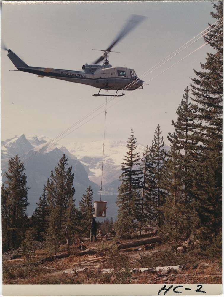
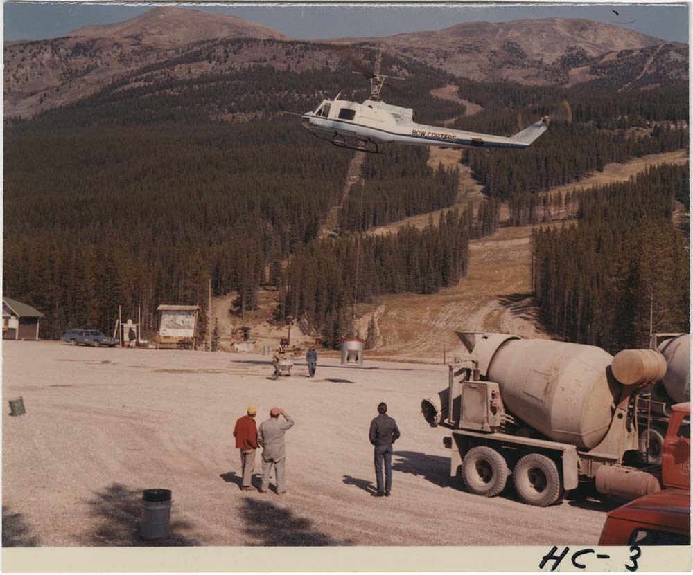
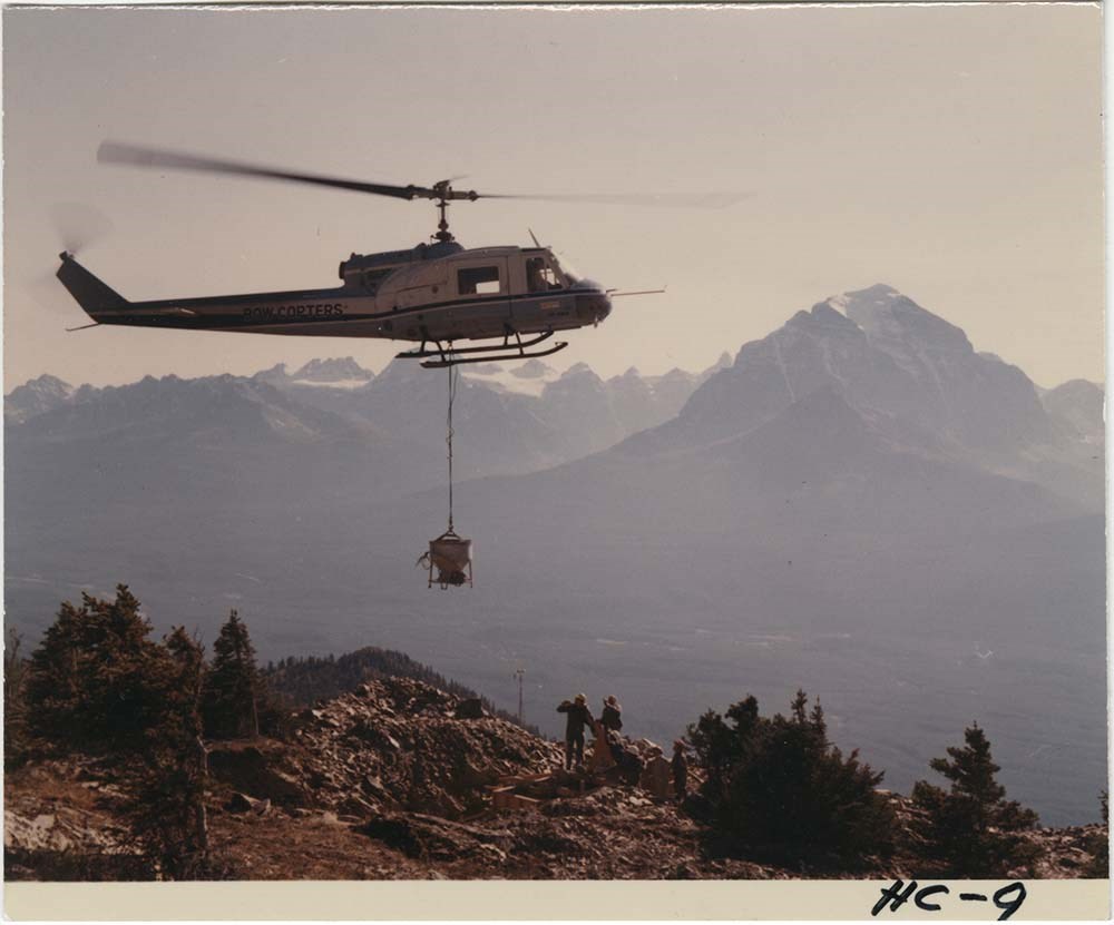
Bow Helicopter - Lake Louise
https://archives.whyte.org/en/permalink/descriptions57484
- Part Of
- Bruno Engler fonds
- Scope & Content
- File pertains to 3 colour prints of a helicopter [operated by the company Bow Helicopters] installing a new chairlift at Lake Louise Ski Hill.
- Date Range
- 1971
- Reference Code
- V190 / VI / B / x / PA - 01 to PA - 03
- Description Level
- 5 / File
- GMD
- Photograph
3 images
- Part Of
- Bruno Engler fonds
- Description Level
- 5 / File
- Fonds Number
- M323 / S40 / V190
- Series
- VI : Retained file, B : Alphabetical order
- Sous-Fonds
- V190
- Sub-Series
- x : Bow Helicopter - Lake Louise
- Accession Number
- 7436
- Reference Code
- V190 / VI / B / x / PA - 01 to PA - 03
- GMD
- Photograph
- Date Range
- 1971
- Physical Description
- 3 photographs : col. ; 12.1 x 9.1 cm
- History / Biographical
- See fonds level description
- Scope & Content
- File pertains to 3 colour prints of a helicopter [operated by the company Bow Helicopters] installing a new chairlift at Lake Louise Ski Hill.
- Subject Access
- Activities
- Buildings
- Chairlifts and gondolas
- Construction
- Helicopters
- Lake Louise Ski Area
- Mountains
- scenic
- Ski area
- Temple Mountain
- Geographic Access
- Lake Louise
- Banff National Park
- Alberta
- Language
- English
- Related Material
- V190 / VI / B / x / NA - 01 to NA - 14 V190 / VI / B / x / NS - 01 to NS - 13
- Creator
- Engler, Bruno
- Title Source
- Original title kept
- Processing Status
- Processed
Images
This material is presented as originally created; it may contain outdated cultural descriptions and
potentially offensive content.
Read more.
Bow Helicopter - Lake Louise - negatives
https://archives.whyte.org/en/permalink/descriptions57485
- Part Of
- Bruno Engler fonds
- Scope & Content
- File pertains to 14 colour negatives of a helicopter [operated by the company Bow Helicopters] installing a new chairlift at Lake Louise Ski Hill.
- Date Range
- 1971
- Reference Code
- V190 / VI / B / x / NA - 01 to NA - 14
- Description Level
- 5 / File
- GMD
- Negative
- Transparency
- Part Of
- Bruno Engler fonds
- Description Level
- 5 / File
- Fonds Number
- M323 / S40 / V190
- Series
- VI : Retained file, B : Alphabetical order
- Sous-Fonds
- V190
- Sub-Series
- x : Bow Helicopter - Lake Louise
- Accession Number
- 7436
- Reference Code
- V190 / VI / B / x / NA - 01 to NA - 14
- GMD
- Negative
- Transparency
- Date Range
- 1971
- Physical Description
- 14 photographs : col. negatives ; 6.1 x 7.7 cm
- History / Biographical
- See fonds level description
- Scope & Content
- File pertains to 14 colour negatives of a helicopter [operated by the company Bow Helicopters] installing a new chairlift at Lake Louise Ski Hill.
- Subject Access
- Activities
- Buildings
- Chairlifts and gondolas
- Construction
- Helicopters
- Lake Louise Ski Area
- Mountains
- scenic
- Ski area
- Temple Mountain
- Geographic Access
- Lake Louise
- Banff National Park
- Alberta
- Language
- English
- Related Material
- V190 / VI / B / x / PA - 01 to PA - 03 V190 / VI / B / x / NS - 01 to NS - 13
- Creator
- Engler, Bruno
- Title Source
- Original title kept
- Processing Status
- Processed
This material is presented as originally created; it may contain outdated cultural descriptions and
potentially offensive content.
Read more.
Bow Helicopter - Lake Louise - transparencies
https://archives.whyte.org/en/permalink/descriptions57486
- Part Of
- Bruno Engler fonds
- Scope & Content
- File pertains to 13 colour film transparencies of a helicopter [operated by the company Bow Helicopters] installing a new chairlift at Lake Louise Ski Hill.
- Date Range
- 1971
- Reference Code
- V190 / VI / B / x / NS - 01 to NS - 13
- Description Level
- 5 / File
- GMD
- Film
- Transparency
- Part Of
- Bruno Engler fonds
- Description Level
- 5 / File
- Fonds Number
- M323 / S40 / V190
- Series
- VI : Retained file, B : Alphabetical order
- Sous-Fonds
- V190
- Sub-Series
- x : Bow Helicopter - Lake Louise
- Accession Number
- 7436
- Reference Code
- V190 / VI / B / x / NS - 01 to NS - 13
- GMD
- Film
- Transparency
- Date Range
- 1971
- Physical Description
- 13 photographs : col. slides ; medium format
- History / Biographical
- See fonds level description
- Scope & Content
- File pertains to 13 colour film transparencies of a helicopter [operated by the company Bow Helicopters] installing a new chairlift at Lake Louise Ski Hill.
- Subject Access
- Activities
- Buildings
- Chairlifts and gondolas
- Construction
- Helicopters
- Lake Louise Ski Area
- Mountains
- scenic
- Ski area
- Temple Mountain
- Geographic Access
- Lake Louise
- Banff National Park
- Alberta
- Language
- English
- Related Material
- V190 / VI / B / x / PA - 01 to PA - 03 V190 / VI / B / x / NA - 01 to NA - 14
- Creator
- Engler, Bruno
- Title Source
- Original title kept
- Processing Status
- Processed
This material is presented as originally created; it may contain outdated cultural descriptions and
potentially offensive content.
Read more.
Castle Mountain Summit Registers
https://archives.whyte.org/en/permalink/descriptions57673
- Part Of
- Alpine Club of Canada fonds
- Scope & Content
- Files consist of summit notes and summit registers from Castle Mountain produced by the Alpine Club of Canada between 1995 and 2010. Summit records include entries from visitors to the various summits which pertain to individuals' hiking and climbing trips; details of specific events which occurred…
- Date Range
- 1995-2003
- 2005-2010
- Reference Code
- M200 / V / A / 51 to 53
- Description Level
- 5 / File
- GMD
- Textual record
- Organization record
- Part Of
- Alpine Club of Canada fonds
- Description Level
- 5 / File
- Fonds Number
- M200
- V14
- S6
- Series
- M200 / V: Summit Records
- Sous-Fonds
- M200
- Sub-Series
- M200 / V / A: Identified Summit Records
- Accession Number
- accn. 7779
- accn. 8119
- Reference Code
- M200 / V / A / 51 to 53
- Responsibility
- Summit Registers and Notes produced by Alpine Club of Canada
- Date Range
- 1995-2003
- 2005-2010
- Physical Description
- 3 volumes 3 cm of textual records
- History / Biographical
- Castle Mountain is located in Banff National Park. The mountain is named for the castle-like appearance due to erosion. From 1946 to 1979 it was known as Mount Eisenhower in honour of war veteran, General Dwight D. Eisenhower. The pinnacle on the mountain's southeastern side is called Eisenhower Tower or Eisenhower Peak.
- Scope & Content
- Files consist of summit notes and summit registers from Castle Mountain produced by the Alpine Club of Canada between 1995 and 2010. Summit records include entries from visitors to the various summits which pertain to individuals' hiking and climbing trips; details of specific events which occurred while at the summit, wildlife sightings, trail updates, and related topics. Files include: M200 / V / A / 51: Castle Mountain Summit Register 1995 - 1998 M200 / V / A / 52: Castle Mountain Sep 26, 1998 - July 20, 2003 M200 / V / A / 53: Summit Reg. Castle Mtn. [2005 - 2010]
- Name Access
- Alpine Club of Canada
- Subject Access
- Alberta
- Alpine Club of Canada
- Backcountry skiing
- Backpacking
- Banff National Park
- Bow Valley
- Castle Mountain
- Climbing
- Environment
- Environment and Nature
- Hiking
- Mountain
- Mountaineering
- Mountaineers
- Mountains
- National parks and reserves
- Ski mountaineering
- Skiing
- Ski area
- Ski areas
- Sports and leisure
- Sports and recreation
- Summit
- Trails
- Winter sports
- Geographic Access
- Canada
- Alberta
- Banff National Park
- Bow Valley
- Canadian Rocky Mountains
- Castle Mountain
- Castle Mountain, AB
- Mount Eisenhower
- Rocky Mountains
- Access Restrictions
- Restrictions may apply
- Reproduction Restrictions
- Contains personal information
- Language
- English
- Japanese
- Mandarin
- French
- Related Material
- M235
- Biographical Source Notes
- A history of West Castle to Castle Mountain Resort 1967 to 2007 : for skiing pleasure unlimited, 2014, Steven Kenworthy, Whyte Museum of the Canadian Rockies, Archives Library, Call No: 08.3 K42h
- Title Source
- Title based on contents of file
- Processing Status
- Processed
This material is presented as originally created; it may contain outdated cultural descriptions and
potentially offensive content.
Read more.
Fairmont Hot Springs
https://archives.whyte.org/en/permalink/descriptions54807
- Part Of
- Murray Hay fonds
- Scope & Content
- File consists of 1 cm of textual records, 23 x 30 cm. File pertains to alpine and cross-country ski trail maps at Fairmont Hot Springs created by Murray Hay. File includes a reproduced map of the resort village and ski areas that was included in a bound brochure promoting Vacation Lease Ownership a…
- Date Range
- ca. 1980 - ca. 1990
- Reference Code
- M570 / III / A / vi / 1
- Description Level
- 5 / File
- GMD
- Map
- Textual record
- Published record
- Part Of
- Murray Hay fonds
- Description Level
- 5 / File
- Fonds Number
- M570 / V795
- Series
- M570 / III : Murray Hay portfolio (published material)
- Sous-Fonds
- M570
- Sub-Series
- M570 / III / A : British Columbia / vi : Fairmont Hot Springs
- Accession Number
- 2019.41
- Reference Code
- M570 / III / A / vi / 1
- Date Range
- ca. 1980 - ca. 1990
- Physical Description
- 1 cm of textual records (23 x 30 cm)
- Scope & Content
- File consists of 1 cm of textual records, 23 x 30 cm. File pertains to alpine and cross-country ski trail maps at Fairmont Hot Springs created by Murray Hay. File includes a reproduced map of the resort village and ski areas that was included in a bound brochure promoting Vacation Lease Ownership at the Fairmont Hot Springs Villas.
- Name Access
- Hay, Murray
- Subject Access
- Cartography
- Map
- Ski Maps
- Skiing
- Ski area
- Hot Springs
- Resort
- Winter sports
- Tourism
- Tourist information
- Travel
- Advertising
- Artist
- Geographic Access
- British Columbia
- Canada
- Fairmont Hot Springs
- Language
- English
- Related Material
- V795 / II / A / viii / 1
- Title Source
- Title based on contents of file
- Processing Status
- Processed
This material is presented as originally created; it may contain outdated cultural descriptions and
potentially offensive content.
Read more.
Fernie Alpine Resort
https://archives.whyte.org/en/permalink/descriptions54883
- Part Of
- Murray Hay fonds
- Scope & Content
- File consists of 2 maps (1 base, 4 overlays) : col., annotations, on mylar ; 32 x 27 cm and 30 x 22 cm, and 2 prints : col. ; 35 x 28 cm. File pertains to Murray Hay's rendering of the ski hill at Fernie, British Columbia. File includes two reproduced drafts with mylar overlays (one held together b…
- Date Range
- ca.1977-ca.1997
- Reference Code
- V795 / II / A / vi / 1-2
- Description Level
- 5 / File
- GMD
- Map
- Private record
- Part Of
- Murray Hay fonds
- Description Level
- 5 / File
- Fonds Number
- M570 / V795
- Series
- V795 / II : Unpublished Material
- Sous-Fonds
- V795
- Sub-Series
- V795 / II / A : British Columbia / vi : Fernie
- Accession Number
- 2019.41
- Reference Code
- V795 / II / A / vi / 1-2
- GMD
- Map
- Private record
- Date Range
- ca.1977-ca.1997
- Physical Description
- 2 maps (1 base, 4 overlays) : col., annotations, on mylar ; 32 x 27 cm and 30 x 22 cm
- 2 prints : col. ; 35 x 28 cm
- Scope & Content
- File consists of 2 maps (1 base, 4 overlays) : col., annotations, on mylar ; 32 x 27 cm and 30 x 22 cm, and 2 prints : col. ; 35 x 28 cm. File pertains to Murray Hay's rendering of the ski hill at Fernie, British Columbia. File includes two reproduced drafts with mylar overlays (one held together by tape or glue, the other by masking tape), and two reproduced draft prints of the ski area.
- Notes
- Date range is approximate. The Timberland sub-division was developed between 1981-1991. The resort was known as Fernie Snow Valley until 1997.
- Name Access
- Hay, Murray
- Subject Access
- Advertising
- Art
- Artist
- Ski Maps
- Cartography
- Sports and recreation
- Tourism
- Tourist information
- Winter
- Winter sports
- Ski area
- Geographic Access
- Fernie
- British Columbia
- Canada
- Canadian Rocky Mountains
- Language
- English
- Conservation
- Masking tape should be removed and alternative preservation methods should be considered at a reasonable time to do so.
- Creator
- Hay, Murray
- Title Source
- Title based on contents of file
- Processing Status
- Processed
This material is presented as originally created; it may contain outdated cultural descriptions and
potentially offensive content.
Read more.
Heart Mountain summit register May 9, 1999 - Sept 11/99
https://archives.whyte.org/en/permalink/descriptions57723
- Part Of
- Alpine Club of Canada fonds
- Scope & Content
- File consists of a summit record from Heart Mountain produced by the Alpine Club of Canada in 1999. Summit record includes entries from visitors to the various summits which pertain to individuals' hiking and climbing trips; details of specific events which occurred while at the summit, wildlife si…
- Date Range
- 1999
- Reference Code
- M200 / V / A / 132
- Description Level
- 5 / File
- GMD
- Textual record
- Organization record
- Part Of
- Alpine Club of Canada fonds
- Description Level
- 5 / File
- Fonds Number
- M200
- V14
- S6
- Series
- M200 / V: Summit Records
- Sous-Fonds
- M200
- Sub-Series
- M200 / V / A: Identified Summit Records
- Accession Number
- accn. 7779
- Reference Code
- M200 / V / A / 132
- Responsibility
- Summit Registers and Notes produced by Alpine Club of Canada
- Date Range
- 1999
- Physical Description
- 1 cm of textual record 1 volume
- History / Biographical
- Heart Mountain is located in the Bow Valley, near Exshaw, Alberta.
- Scope & Content
- File consists of a summit record from Heart Mountain produced by the Alpine Club of Canada in 1999. Summit record includes entries from visitors to the various summits which pertain to individuals' hiking and climbing trips; details of specific events which occurred while at the summit, wildlife sightings, trail updates, and related topics. File: M200 / V / A / 132: Heart Mountain summit register May 9, 1999 - Sept 11/99
- Name Access
- Alpine Club of Canada
- Subject Access
- Alberta
- Alpine Club of Canada
- Backcountry skiing
- Backpacking
- Bow Valley
- Climbing
- Club
- Description and travel
- Environment
- Environment and Nature
- Hiking
- Mountain
- Mountaineering
- Mountaineers
- Mountains
- Record keeping
- Ski area
- Ski areas
- Ski mountaineering
- Skiing
- Skis
- Skiers
- Snowshoes and snowshoeing
- Sports and leisure
- Sports and recreation
- Summit
- Trails
- Winter sports
- Geographic Access
- Canada
- Canadian Rocky Mountains
- Rocky Mountains
- Alberta
- Bow Valley
- Canmore
- Canmore, AB
- Exshaw
- Exshaw, AB
- Access Restrictions
- Restrictions may apply
- Language
- English
- Related Material
- M235
- Title Source
- Original title
- Processing Status
- Processed
This material is presented as originally created; it may contain outdated cultural descriptions and
potentially offensive content.
Read more.
Identified Summit Records
https://archives.whyte.org/en/permalink/descriptions57799
- Part Of
- Alpine Club of Canada fonds
- Scope & Content
- Sub-series of identified summit registers and notes produced by the Alpine Club of Canada between 1930 and 2022. Summit records include entries from visitors to the various summits which pertain to individuals' hiking and climbing trips; details of specific events which occurred while at the summit…
- Date Range
- 1930-1931
- 1959-1968
- 1970-1989
- 1992 -2022
- Reference Code
- M200 / V / A
- Description Level
- 4 / Sub-series
- GMD
- Textual record
- Organization record
- Part Of
- Alpine Club of Canada fonds
- Description Level
- 4 / Sub-series
- Fonds Number
- M200
- V14
- S6
- Series
- M200 / V: Summit Records
- Sous-Fonds
- M200
- Sub-Series
- M200 / V / A: Identified Summit Records
- Accession Number
- accn. 2023.20 accn. 7779 accn. 2023.10 accn. 2014.8347 accn. 6465 accn. 8002 accn. 2020.05 accn. 2023.19 accn. 2014.8293 accn. 8119 accn. 2023.32 accn. 2023.41 accn. 6623 accn. 6062 accn. 2014.8318 accn. 6767 accn. 2014.8315 accn. 2014.8317 accn. 5680 accn. 2023.16 accn. 2018.9010 accn. 5396 accn. 6459 accn. 2014.8316 accn. 2023.18 accn. 5631 accn. 2013.8245 accn. 2014.8275 accn. 2023.06 accn. 2023.14 accn. 2023.17 accn. 5569 accn. 8113 accn. 6396 accn. 2024.20
- Reference Code
- M200 / V / A
- Responsibility
- Summit Registers and Notes produced by Alpine Club of Canada
- Date Range
- 1930-1931
- 1959-1968
- 1970-1989
- 1992 -2022
- Physical Description
- 100 cm of textual records 223 volumes
- Scope & Content
- Sub-series of identified summit registers and notes produced by the Alpine Club of Canada between 1930 and 2022. Summit records include entries from visitors to the various summits which pertain to individuals' hiking and climbing trips; details of specific events which occurred while at the summit, wildlife sightings, trail updates, and related topics. The sub-series is separated into individual identified summit records.
- Notes
- See file-level entries for inventories of identified summit registers and notes.
- Name Access
- Alpine Club of Canada
- Subject Access
- Alberta
- Alpine Club of Canada
- Backpacking
- Backcountry skiing
- Banff
- Banff National Park
- Bow Valley
- British Columbia
- Castle Mountain
- Cascade Mountain
- Centennial
- Climbing
- Club
- Cross-country skiing
- Description and travel
- Environment
- Environment and Nature
- Fortress Mountain
- Great Divide
- Hiking
- Kananaskis Country
- Mount Assiniboine
- Mount Logan
- Mountain
- Mountain guides
- Mountaineering
- Mountaineers
- Mountains
- Provincial parks and reserves
- Parks
- National parks and reserves
- Record keeping
- Ski area
- Ski areas
- Ski mountaineering
- Skiing
- Skis
- Skiers
- Snowshoes and snowshoeing
- Sports and leisure
- Sports and recreation
- Summit
- Trails
- Winter sports
- Geographic Access
- Canada
- Canadian Rocky Mountains
- Rocky Mountains
- Continental Divide
- Great Divide
- Alberta
- British Columbia
- Abbot Pass
- Mount Assiniboine
- Cascade Mountain
- Canmore
- Assiniboine
- Banff National Park
- Banff, Alberta
- Bugaboos
- Castle Mountain, AB
- Cathedral Mountain
- Glacier
- Jasper National Park
- Kananaskis Country
- Little Yoho Valley
- Mount Baldy
- Mount Baker
- Mount Cory
- Mount Edith
- Mount Lefroy
- Mount Norquay
- Mount Rundle
- Rundle Mountain
- Mount Temple
- Mount Victoria
- Mount Yamnuska
- Selkirks
- Yoho National Park
- Access Restrictions
- Restrictions may apply
- Reproduction Restrictions
- Contains personal information
- Language
- English
- Conservation
- Some records have been placed in mylar. Some record have mold, rust or water damage.
- Related Material
- M235
- Title Source
- Title based on contents of sub-series
- Processing Status
- Processed
This material is presented as originally created; it may contain outdated cultural descriptions and
potentially offensive content.
Read more.
Isolated Peak Summit Records
https://archives.whyte.org/en/permalink/descriptions57690
- Part Of
- Alpine Club of Canada fonds
- Scope & Content
- Files consist of summit notes and summit registers and notes from Isolated Peak between 1996 and 2012 produced by the Alpine Club of Canada. Summit records include entries from visitors to the various summits which pertain to individuals' hiking and climbing trips; details of specific events which …
- Date Range
- 1996-2012
- Reference Code
- M200 / V / A / 83 to 84
- Description Level
- 5 / File
- GMD
- Textual record
- Organization record
- Part Of
- Alpine Club of Canada fonds
- Description Level
- 5 / File
- Fonds Number
- M200
- V14
- S6
- Series
- M200 / V: Summit Records
- Sous-Fonds
- M200
- Sub-Series
- M200 / V / A: Identified Summit Records
- Accession Number
- accn. 8002
- accn. 2023.19
- Reference Code
- M200 / V / A / 83 to 84
- Responsibility
- Summit Registers and Notes produced by Alpine Club of Canada
- Date Range
- 1996-2012
- Physical Description
- 2 volumes ca. 2 cm of textual records
- History / Biographical
- Isolated Peak is located in Little Yoho Valley of Yoho National Park, B.C. in the Canadian Rockies. Nearby are Mount McArthur, Arete Peak and Mont des Poilus, Vice President and President Mountains.
- Scope & Content
- Files consist of summit notes and summit registers and notes from Isolated Peak between 1996 and 2012 produced by the Alpine Club of Canada. Summit records include entries from visitors to the various summits which pertain to individuals' hiking and climbing trips; details of specific events which occurred while at the summit, wildlife sightings, trail updates, and related topics. Files include: M200 / V / A / 83: Summit Register - Isolated Peak, July 1996 - Aug 2009 M200 / V / A / 84: Isolated Peak [2009-2012]
- Name Access
- Alpine Club of Canada
- Subject Access
- Alpine Club of Canada
- Backpacking
- Backcountry skiing
- British Columbia
- Climbing
- Club
- Cross-country skiing
- Description and travel
- Environment
- Environment and Nature
- Hiking
- Mountain
- Mountaineering
- Mountaineers
- Mountains
- National parks and reserves
- Parks Canada
- Record keeping
- Ski area
- Ski areas
- Ski mountaineering
- Skiing
- Skiers
- Snowshoes and snowshoeing
- Sports and leisure
- Sports and recreation
- Summit
- Trails
- Winter sports
- Geographic Access
- Canada
- Canadian Rocky Mountains
- Rocky Mountains
- British Columbia
- Yoho National Park
- Little Yoho Valley
- The Vice President
- The President
- Isolated Peak
- Access Restrictions
- Restrictions may apply
- Language
- English
- French
- Conservation
- Summit notes are loose pages and contain water damage. Summit notes may contain rust damage.
- Related Material
- M235
- Biographical Source Notes
- Peak Finder, Isolated Peak, Canadian Rockies Database: https://cdnrockiesdatabases.ca/peaks/687#undefined1
- Title Source
- Title based on contents of file
- Processing Status
- Processed
This material is presented as originally created; it may contain outdated cultural descriptions and
potentially offensive content.
Read more.
- Part Of
- Murray Hay fonds
- Scope & Content
- File consists of 1 cm of textual records, 21 x 29.5 cm. File pertains to the Alts Ski Area in Japan for which Murray Hay created a trail map. File includes one tourist booklet that includes Hay's trail map.
- Date Range
- ca. 1995
- Reference Code
- M570 / III / D / ii / 2
- Description Level
- 5 / File
- GMD
- Map
- Published record
- Textual record
- Part Of
- Murray Hay fonds
- Description Level
- 5 / File
- Fonds Number
- M570 / V795
- Series
- M570 / III : Murray Hay portfolio (published material)
- Sous-Fonds
- M570
- Sub-Series
- M570 / III / D : Miscellaneous / ii : International
- Accession Number
- 2019.41
- Reference Code
- M570 / III / D / ii / 2
- Date Range
- ca. 1995
- Physical Description
- 1 cm of textual records (21 x 29.5 cm)
- Scope & Content
- File consists of 1 cm of textual records, 21 x 29.5 cm. File pertains to the Alts Ski Area in Japan for which Murray Hay created a trail map. File includes one tourist booklet that includes Hay's trail map.
- Notes
- The booklet is in Japanese.
- Name Access
- Hay, Murray
- Subject Access
- Advertising
- Artist
- Ski Maps
- Ski area
- Skiing
- Cartography
- Map
- Sports and recreation
- Tourism
- Tourist information
- Travel
- Winter
- Winter sports
- Geographic Access
- Japan
- Language
- Japanese
- English
- Related Material
- V795 / II / D / ii / 1
- Title Source
- Title based on contents of file
- Processing Status
- Processed
This material is presented as originally created; it may contain outdated cultural descriptions and
potentially offensive content.
Read more.
Kananaskis and Spray Lakes
https://archives.whyte.org/en/permalink/descriptions54802
- Part Of
- Murray Hay fonds
- Scope & Content
- File consists of 1.5 cm of textual records, 35 x 35 cm or smaller. File pertains to travel and tourism materials related to the Kananaskis-Canmore area. File includes four published Murray Hay trail maps of ski hills in Kananaskis (Nakiska, Fortress, Mount Allan) and a travel brochure relating to t…
- Date Range
- 1978 - ca.1995
- 1988
- 1978-1979
- Reference Code
- M570 / III / B / iv / 1-2
- Description Level
- 5 / File
- GMD
- Map
- Published record
- Textual record
- Poster
- Part Of
- Murray Hay fonds
- Description Level
- 5 / File
- Fonds Number
- M570 / V795
- Series
- M570 / III : Murray Hay portfolio (published material)
- Sous-Fonds
- M570
- Sub-Series
- M570 / III / B : Alberta / iv : Kananaskis
- Accession Number
- 2019.41
- Reference Code
- M570 / III / B / iv / 1-2
- Date Range
- 1978 - ca.1995
- 1988
- 1978-1979
- Physical Description
- 1.5 cm of textual records (35 x 35 cm or smaller)
- Scope & Content
- File consists of 1.5 cm of textual records, 35 x 35 cm or smaller. File pertains to travel and tourism materials related to the Kananaskis-Canmore area. File includes four published Murray Hay trail maps of ski hills in Kananaskis (Nakiska, Fortress, Mount Allan) and a travel brochure relating to the Kananaskis and Canmore area. The Mount Allan maps include recreational ski runs and Olympic ski runs.
- Notes
- M570 / III / B / iv / 2 is oversize.
- Name Access
- Hay, Murray
- Subject Access
- Ski area
- Ski Maps
- Skiing
- Cartography
- Map
- Tourism
- Travel
- Winter
- Winter sports
- Nakiska Ski Area
- Fortress Mountain
- Mount Allan
- Tourist information
- Artist
- Advertising
- Geographic Access
- Kananaskis
- Spray Valley
- Alberta
- Canada
- Canmore
- Language
- English
- Title Source
- Title based on contents of file
- Processing Status
- Processed
This material is presented as originally created; it may contain outdated cultural descriptions and
potentially offensive content.
Read more.
- Part Of
- Murray Hay fonds
- Scope & Content
- File consists of 8 colour prints, 28 x 35 cm or smaller. File pertains to Murray Hay's work for the City of Kimberley, British Columbia. File includes prints of original paintings done by Hay relating to a proposed real estate development in the city and the Kimberley ski hill.
- Date Range
- ca.1979-ca.2000
- Reference Code
- V795 / II / A / iii / 1-2
- Description Level
- 5 / File
- GMD
- Map
- Private record
- Part Of
- Murray Hay fonds
- Description Level
- 5 / File
- Fonds Number
- M570 / V795
- Series
- V795 / II : Unpublished Material
- Sous-Fonds
- V795
- Sub-Series
- V795 / II / A : British Columbia / iii : Kimberley
- Accession Number
- 2019.41
- Reference Code
- V795 / II / A / iii / 1-2
- GMD
- Map
- Private record
- Date Range
- ca.1979-ca.2000
- Physical Description
- 8 prints : col. ; 28 x 35 cm or smaller
- Scope & Content
- File consists of 8 colour prints, 28 x 35 cm or smaller. File pertains to Murray Hay's work for the City of Kimberley, British Columbia. File includes prints of original paintings done by Hay relating to a proposed real estate development in the city and the Kimberley ski hill.
- Notes
- The ski hill at Kimberley was developed in 1979.
- Most of the prints are annotated in ink by Hay (his own notes and comments by clients).
- Name Access
- Hay, Murray
- Subject Access
- Advertising
- Artist
- Art
- Cartography
- Community life
- Landscapes
- Map
- Mountains
- Municipal views
- Ski area
- Ski Maps
- Sports and recreation
- Tourism
- Tourist information
- Winter
- Kimberley Alpine Resort
- Geographic Access
- Kimberley
- British Columbia
- Canada
- Purcell Mountains
- Language
- English
- Conservation
- There is masking tape holding some of the prints together on a piece of paper, which should be removed and alternative preservation methods should be considered at a reasonable time to do so.
- Creator
- Hay, Murray
- Title Source
- Title based on contents of file
- Processing Status
- Processed
This material is presented as originally created; it may contain outdated cultural descriptions and
potentially offensive content.
Read more.