Narrow Results By
An Outline Map of the Canadian Pacific Railway and Connecting Lines
https://archives.whyte.org/en/permalink/catalogue21429
- Medium
- Library - Maps and blueprints (unannotated; published)
- Map
- Published Date
- Checked to March 1925
- Call Number
- C11-3.2
- Published Date
- Checked to March 1925
- Subjects
- Canada
- Railway routes
- Notes
- World Cruises described on the reverse side of the map
- Accession Number
- 400
- Call Number
- C11-3.2
- Collection
- Archives Library
This material is presented as originally created; it may contain outdated cultural descriptions and
potentially offensive content.
Read more.
Dominion of Canada and Newfoundland
https://archives.whyte.org/en/permalink/catalogue24550
- Medium
- Library - Maps and blueprints (unannotated; published)
- Map
- Published Date
- 1898
- Publisher
- Rand McNally and Co. Republished by the Royal Canadian Geographical Society in 1967 in recognition of Canada's Centennial
- Call Number
- C11-2.3
- Publisher
- Rand McNally and Co. Republished by the Royal Canadian Geographical Society in 1967 in recognition of Canada's Centennial
- Published Date
- 1898
- Scale
- Scale: 180 miles - 1 inch
- Subjects
- Canada
- Notes
- Duplicate in map room/Accn: 400)
- Accession Number
- 400
- 673
- Call Number
- C11-2.3
- Collection
- Archives Library
This material is presented as originally created; it may contain outdated cultural descriptions and
potentially offensive content.
Read more.
Map of the Dominion of Canada
https://archives.whyte.org/en/permalink/catalogue24572
- Medium
- Library - Maps and blueprints (unannotated; published)
- Map
- Published Date
- 1961
- Publisher
- Bureau of Statistics
- Call Number
- C11-4.9
- Responsibility
- Compiled and drawn by the Dept. of Mines & Technical Surveys for Canada Year Book
- Publisher
- Bureau of Statistics
- Published Date
- 1961
- Scale
- 140 miles to 1 inch
- Subjects
- Canada
- Accession Number
- 3070
- Call Number
- C11-4.9
- Collection
- Archives Library
This material is presented as originally created; it may contain outdated cultural descriptions and
potentially offensive content.
Read more.
Railway Map of the Dominion of Canada
https://archives.whyte.org/en/permalink/catalogue21430
- Medium
- Library - Maps and blueprints (unannotated; published)
- Map
- Published Date
- 1920
- Call Number
- C11-3.4(a) to 3.4(h)
- Published Date
- 1920
- Subjects
- Canada
- Railway routes
- Notes
- A series of eight maps from Labrador to British Columbia showing railway routes.
- See: Title map C11-3.4(a), Legend C11-3.4(d), Index C11-3.4(e)
- Accession Number
- 400
- Call Number
- C11-3.4(a) to 3.4(h)
- Collection
- Archives Library
This material is presented as originally created; it may contain outdated cultural descriptions and
potentially offensive content.
Read more.
Trails in the Lake O'Hara area
https://archives.whyte.org/en/permalink/catalogue23399
- Medium
- Library - Maps and blueprints (unannotated; published)
- Map
- Published Date
- 1964
- Publisher
- [Ottawa : National Parks Branch]
- Call Number
- C6-4.4m
- Publisher
- [Ottawa : National Parks Branch]
- Published Date
- 1964
- Physical Description
- 1 map : col
- Scale
- 2.5 inches = 1 mile
- Notes
- Info file transfer
- Call Number
- C6-4.4m
- Collection
- Archives Library
This material is presented as originally created; it may contain outdated cultural descriptions and
potentially offensive content.
Read more.
Trails in the Lake O'Hara area
https://archives.whyte.org/en/permalink/catalogue24332
- Medium
- Library - Maps and blueprints (unannotated; published)
- Map
- Published Date
- 1964
- Publisher
- [Ottawa : National Parks Branch]
- Call Number
- C6-4.4m
- Publisher
- [Ottawa : National Parks Branch]
- Published Date
- 1964
- Physical Description
- 1 map : col
- Scale
- 2.5 inches = 1 mile
- Notes
- Info file transfer
- Call Number
- C6-4.4m
- Collection
- Archives Library
This material is presented as originally created; it may contain outdated cultural descriptions and
potentially offensive content.
Read more.
Trails in the Lake o'Hara area, Yoho National Park
https://archives.whyte.org/en/permalink/catalogue23400
- Medium
- Library - Maps and blueprints (unannotated; published)
- Map
- Published Date
- 1963
- Publisher
- Ottawa : National Parks Branch : Supply and Services Canada
- Call Number
- C6-4.4n
- Publisher
- Ottawa : National Parks Branch : Supply and Services Canada
- Published Date
- 1963
- Physical Description
- 1 map : b & w
- Scale
- 3/4 inches = 1/2 mile
- Notes
- issued under the Authority of Arthur Laing, Minister of Northern Affairs and National Resources
- Info file transfer
- Call Number
- C6-4.4n
- Collection
- Archives Library
This material is presented as originally created; it may contain outdated cultural descriptions and
potentially offensive content.
Read more.
Trails in the Lake o'Hara area, Yoho National Park
https://archives.whyte.org/en/permalink/catalogue24333
- Medium
- Library - Maps and blueprints (unannotated; published)
- Map
- Published Date
- 1963
- Publisher
- Ottawa : National Parks Branch : Supply and Services Canada
- Call Number
- C6-4.4n
- Publisher
- Ottawa : National Parks Branch : Supply and Services Canada
- Published Date
- 1963
- Physical Description
- 1 map : b & w
- Scale
- 3/4 inches = 1/2 mile
- Notes
- issued under the Authority of Arthur Laing, Minister of Northern Affairs and National Resources
- Info file transfer
- Call Number
- C6-4.4n
- Collection
- Archives Library
This material is presented as originally created; it may contain outdated cultural descriptions and
potentially offensive content.
Read more.
- Date
- 1925 – 1966
- Medium
- graphite on paper
- Catalogue Number
- WyP.03.756
- Description
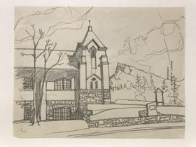
- A very detailed drawing of Banff United Church in the foreground, with a simple sketch of Rundle Mountain in the background. The image is drawn on stationery paper with “BANFF, ALBERTA CANADA” printed on the right side of the page, near the edge. verso: random lines sketched throughout the page
1 image
- Title
- Untitled
- Date
- 1925 – 1966
- Medium
- graphite on paper
- Dimensions
- 21.0 x 28.0 cm
- Description
- A very detailed drawing of Banff United Church in the foreground, with a simple sketch of Rundle Mountain in the background. The image is drawn on stationery paper with “BANFF, ALBERTA CANADA” printed on the right side of the page, near the edge. verso: random lines sketched throughout the page
- Credit
- Gift of Catharine Robb Whyte, O. C., Banff, 1979
- Catalogue Number
- WyP.03.756
Images
This material is presented as originally created; it may contain outdated cultural descriptions and
potentially offensive content.
Read more.


