Narrow Results By
- Peter Whyte (1905 – 1966, Canadian) 47
- Charles John Collings (1848 – 1931, British) 39
- Peggy Dixon 7
- James McLaren Nicoll (1892 – 1986, Canadian) 5
- Robert William Sinclair (1939 – , Canadian) 5
- Peter Karsten (1937 – , Canadian) 4
- Guest, Robert 2
- Homoky, Stephen G. 1
- Mary Garnham Andrews (1916 – 2018, Canadian) 1
- Toft, Murray 1
- Unknown 1
- Wallace, A.W. 1
Alberta, Canada : transportation
https://archives.whyte.org/en/permalink/catalogue24407
- Medium
- Library - Maps and blueprints (unannotated; published)
- Map
- Published Date
- 1980
- Publisher
- Edmonton : Alberta Transportation
- Call Number
- C9-1.17
- Publisher
- Edmonton : Alberta Transportation
- Published Date
- 1980
- Physical Description
- 1 map : col
- Scale
- Scale indeterminable
- Accession Number
- 3287
- Call Number
- C9-1.17
- Collection
- Archives Library
This material is presented as originally created; it may contain outdated cultural descriptions and
potentially offensive content.
Read more.
[Alberta] Department of Highways and Transport District Boundaries
https://archives.whyte.org/en/permalink/catalogue21405
- Medium
- Library - Maps and blueprints (unannotated; published)
- Map
- Published Date
- 1969
- Publisher
- Surveys Branch, Department of Highways and Transport
- Call Number
- C9-5.8
- Publisher
- Surveys Branch, Department of Highways and Transport
- Published Date
- 1969
- Subjects
- Alberta
- Notes
- Legend in colour
- Accession Number
- SG7500
- Call Number
- C9-5.8
- Collection
- Archives Library
This material is presented as originally created; it may contain outdated cultural descriptions and
potentially offensive content.
Read more.
[Alberta] Population by Township and Incorporated Places, 1966 Census of Canada
https://archives.whyte.org/en/permalink/catalogue24425
- Medium
- Library - Maps and blueprints (unannotated; published)
- Map
- Published Date
- 1966
- Publisher
- Surveys Branch, Dept. of Hwys
- Call Number
- C9-5.2(b)
- Publisher
- Surveys Branch, Dept. of Hwys
- Published Date
- 1966
- Physical Description
- 1 map : black and white
- Scale
- Scale: 12 miles: 1 inch
- Subjects
- Alberta
- Alberta-Population
- Notes
- Xerox copy
- Accession Number
- AG7500
- Call Number
- C9-5.2(b)
- Collection
- Archives Library
This material is presented as originally created; it may contain outdated cultural descriptions and
potentially offensive content.
Read more.
[Alberta] Population by Townships and Urban Centres 1961 Census of Canada
https://archives.whyte.org/en/permalink/catalogue24424
- Medium
- Library - Maps and blueprints (unannotated; published)
- Map
- Published Date
- 1961
- Publisher
- Surveys Branch, Department of Highways
- Call Number
- C9-5.2(a)
- Publisher
- Surveys Branch, Department of Highways
- Published Date
- 1961
- Physical Description
- 1 map : black and white
- Scale
- Scale: 12 miles: 1 inch
- Subjects
- Alberta
- Alberta-Population
- Accession Number
- SG7500
- Call Number
- C9-5.2(a)
- Collection
- Archives Library
This material is presented as originally created; it may contain outdated cultural descriptions and
potentially offensive content.
Read more.
[Alberta, P.R.I.M.E. - Water Resources]
https://archives.whyte.org/en/permalink/catalogue24432
- Medium
- Library - Maps and blueprints (unannotated; published)
- Map
- Published Date
- 1969
- Publisher
- Dept. of Agriculture, Water Resources Division, Development Planning Branch
- Call Number
- C9-5.3
- Publisher
- Dept. of Agriculture, Water Resources Division, Development Planning Branch
- Published Date
- 1969
- Scale
- Scale: 32 miles : 1 inch
- Subjects
- Alberta
- P.R.I.M.E. - Water Resources
- Accession Number
- 778
- Call Number
- C9-5.3
- Collection
- Archives Library
This material is presented as originally created; it may contain outdated cultural descriptions and
potentially offensive content.
Read more.
Alberta, Saskatchewan
https://archives.whyte.org/en/permalink/catalogue24580
- Medium
- Library - Maps and blueprints (unannotated; published)
- Map
- Published Date
- 1964
- Publisher
- Royal Canadian Geographical Society
- Call Number
- C11-6.2
- Publisher
- Royal Canadian Geographical Society
- Published Date
- 1964
- Scale
- 32 miles (approx) to 1 inch
- Subjects
- Canada - Prairie Region
- Accession Number
- 495
- Call Number
- C11-6.2
- Collection
- Archives Library
This material is presented as originally created; it may contain outdated cultural descriptions and
potentially offensive content.
Read more.
[Alert Bay 92L, B.C.]
https://archives.whyte.org/en/permalink/catalogue24003
- Medium
- Library - Maps and blueprints (unannotated; published)
- Map
- Published Date
- 1965
- Publisher
- Army Survey Establishment
- Call Number
- NTS
- 92L
- Publisher
- Army Survey Establishment
- Published Date
- 1965
- Physical Description
- 1 map : col
- Scale
- Scale: 1:250,00
- Relief: Contour interval 500 ft.
- Subjects
- Alert Bay
- British Columbia
- Notes
- National Topographic System
- Accession Number
- 5500
- Call Number
- NTS
- 92L
- Collection
- Archives Library
This material is presented as originally created; it may contain outdated cultural descriptions and
potentially offensive content.
Read more.
[Almond Mountain 82E/7]
https://archives.whyte.org/en/permalink/catalogue23447
- Medium
- Library - Maps and blueprints (unannotated; published)
- Map
- Published Date
- 1968
- Publisher
- Department of Energy, Mines and Resources
- Call Number
- NTS
- 82E/7
- Publisher
- Department of Energy, Mines and Resources
- Published Date
- 1968
- Physical Description
- 1 map : col
- Scale
- Scale: 1:50,000
- Relief: Contour interval 100 ft.
- Subjects
- Almond Mountain
- Notes
- National Topographic System
- Accession Number
- 7000
- Call Number
- NTS
- 82E/7
- Collection
- Archives Library
This material is presented as originally created; it may contain outdated cultural descriptions and
potentially offensive content.
Read more.
[Alsek River 114 NE, B.C.-Alaska]
https://archives.whyte.org/en/permalink/catalogue24174
- Medium
- Library - Maps and blueprints (unannotated; published)
- Map
- Published Date
- 1965
- Publisher
- Dept. of Mines and Technical Surveys
- Call Number
- NTS
- 114NE
- Publisher
- Dept. of Mines and Technical Surveys
- Published Date
- 1965
- Scale
- Scale: 1:500,000
- Altitude tints
- Subjects
- Alsek River
- British Columbia/Alaska
- Notes
- National Topographic System
- Accession Number
- 3000
- Call Number
- NTS
- 114NE
- Collection
- Archives Library
This material is presented as originally created; it may contain outdated cultural descriptions and
potentially offensive content.
Read more.
Amethyst Lakes, Alberta-British Columbia
https://archives.whyte.org/en/permalink/catalogue23448
- Medium
- Library - Maps and blueprints (unannotated; published)
- Map
- Published Date
- 1984
- Publisher
- Ottawa : Surveys and Mapping Branch, Dept. of Energy, Mines and Resources
- Edition
- 2d ed.
- Call Number
- NTS
- 83D/9
- Edition
- 2d ed.
- Publisher
- Ottawa : Surveys and Mapping Branch, Dept. of Energy, Mines and Resources
- Published Date
- 1984
- Physical Description
- 1 map : col
- Scale
- Scale: 1:50,000
- Subjects
- Amethyst Lakes
- Alberta/British Columbia
- Accession Number
- 27,000
- Call Number
- NTS
- 83D/9
- Collection
- Archives Library
This material is presented as originally created; it may contain outdated cultural descriptions and
potentially offensive content.
Read more.
An illustrated plan of the city of Halifax
https://archives.whyte.org/en/permalink/catalogue21442
- Medium
- Library - Maps and blueprints (unannotated; published)
- Map
- Published Date
- 1983
- Author
- Wallace, A.W.
- Call Number
- C11-8.2
- Author
- Wallace, A.W.
- Responsibility
- Map drawn by A.W. Wallace/1935
- Published Date
- 1983
- Subjects
- Canada - Maritime Region
- Halifax
- Notes
- Representative of the social, commercial and industrial life of the city of Halifax
- With harbour facilities and street index. With places of historical interest noted
- Accession Number
- 400
- Call Number
- C11-8.2
- Collection
- Archives Library
This material is presented as originally created; it may contain outdated cultural descriptions and
potentially offensive content.
Read more.
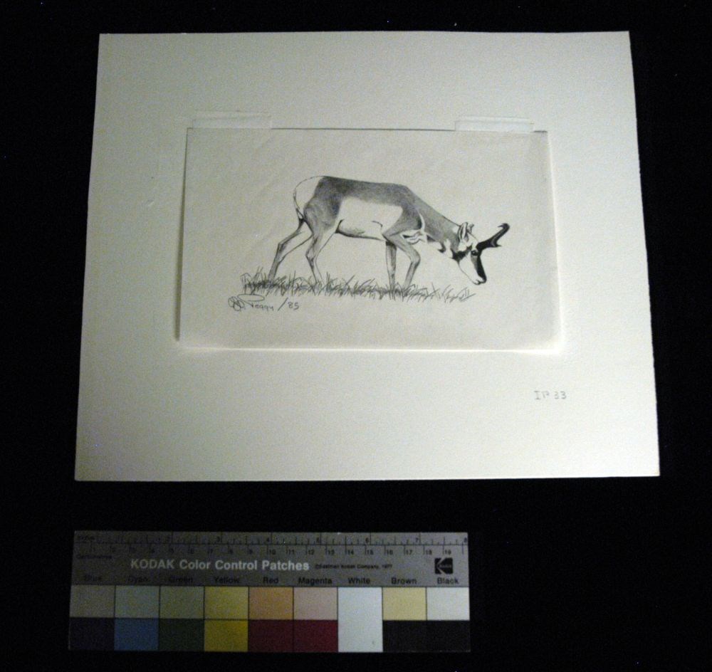
- Artist
- Peggy Dixon
- Date
- 1985
- Medium
- graphite on paper
- Catalogue Number
- DiP.03.04
- Description
- An antelope faces to the right in fully body profile. Grass lines the bottom of the image. At the lower right corner of the matt “IP 33.” On the back of the image is an erased sketch of a person riding a horse on the right, and a person holding a rope on the left.
1 image
- Artist
- Peggy Dixon
- Title
- Antelope Buck
- Date
- 1985
- Medium
- graphite on paper
- Dimensions
- 12.5 x 20.3 cm
- Description
- An antelope faces to the right in fully body profile. Grass lines the bottom of the image. At the lower right corner of the matt “IP 33.” On the back of the image is an erased sketch of a person riding a horse on the right, and a person holding a rope on the left.
- Credit
- Gift of Peggy Dixon, Milk River, 2012
- Catalogue Number
- DiP.03.04
Images
This material is presented as originally created; it may contain outdated cultural descriptions and
potentially offensive content.
Read more.
Archaeological map of Middle America
https://archives.whyte.org/en/permalink/catalogue24826
- Medium
- Library - Maps and blueprints (unannotated; published)
- Map
- Published Date
- 1968
- Publisher
- National Geographic Society
- Call Number
- C13-2.2
- Publisher
- National Geographic Society
- Published Date
- 1968
- Scale
- 35.5 miles to 1 inch
- Subjects
- Mexico, Central America
- Accession Number
- 673
- Call Number
- C13-2.2
- Collection
- Archives Library
This material is presented as originally created; it may contain outdated cultural descriptions and
potentially offensive content.
Read more.
Argonaut Mountain, Kootenay Land District, British Columbia
https://archives.whyte.org/en/permalink/catalogue23451
- Medium
- Library - Maps and blueprints (unannotated; published)
- Map
- Published Date
- 1980
- Publisher
- Ottawa: Surveys and Mapping Branch, Dept. of Energy, Mines and Resources
- Edition
- 2d ed.
- Call Number
- NTS
- 82M/16
- Edition
- 2d ed.
- Publisher
- Ottawa: Surveys and Mapping Branch, Dept. of Energy, Mines and Resources
- Published Date
- 1980
- Physical Description
- 1 map : col
- Scale
- Scale: 1:50,000
- Subjects
- Argonaut Mountain
- British Columbia
- Accession Number
- 27,000
- 7030
- Call Number
- NTS
- 82M/16
- Collection
- Archives Library
This material is presented as originally created; it may contain outdated cultural descriptions and
potentially offensive content.
Read more.
- Medium
- Library - Maps and blueprints (unannotated; published)
- Map
- Published Date
- 1966
- Publisher
- Department of Lands & Forests
- Call Number
- NTS
- 92I/NW
- Publisher
- Department of Lands & Forests
- Published Date
- 1966
- Physical Description
- 1 map : col
- Scale
- Scale: 1:126,720
- Relief: contour interval 100 ft.
- Subjects
- Ashcroft
- British Columbia
- Notes
- National Topographic System
- Accession Number
- 3000
- Call Number
- NTS
- 92I/NW
- Collection
- Archives Library
This material is presented as originally created; it may contain outdated cultural descriptions and
potentially offensive content.
Read more.
[Ashcroft 92I, B.C.]
https://archives.whyte.org/en/permalink/catalogue24006
- Medium
- Library - Maps and blueprints (unannotated; published)
- Map
- Published Date
- 1962
- Publisher
- Dept. of Mines and Technical Surveys
- Call Number
- NTS
- 92I
- Publisher
- Dept. of Mines and Technical Surveys
- Published Date
- 1962
- Physical Description
- 1 map : col
- Scale
- Scale: 1:250,000
- Relief: Contour interval 500 ft.
- Subjects
- Ashcroft
- British Columbia
- Notes
- National Topographic System
- Accession Number
- 3000
- Call Number
- NTS
- 92I
- Collection
- Archives Library
This material is presented as originally created; it may contain outdated cultural descriptions and
potentially offensive content.
Read more.
[Ashnola 92H/1 East, B.C.]
https://archives.whyte.org/en/permalink/catalogue23452
- Medium
- Library - Maps and blueprints (unannotated; published)
- Map
- Published Date
- 1960
- Publisher
- Army Survey Establishment
- Call Number
- NTS
- 92H/1E
- Publisher
- Army Survey Establishment
- Published Date
- 1960
- Physical Description
- 1 map : col
- Scale
- Scale: 1:50,000
- Relief: Contour interval 100 ft.
- Subjects
- Ashnola
- British Columbia
- Notes
- National Topographic System
- Accession Number
- 7000
- Call Number
- NTS
- 92H/1E
- Collection
- Archives Library
This material is presented as originally created; it may contain outdated cultural descriptions and
potentially offensive content.
Read more.
[Ashnola 92H/1 West, B.C.]
https://archives.whyte.org/en/permalink/catalogue23453
- Medium
- Library - Maps and blueprints (unannotated; published)
- Map
- Published Date
- 1960
- Publisher
- Army Survey Establishment
- Call Number
- NTS
- 92H/1W
- Publisher
- Army Survey Establishment
- Published Date
- 1960
- Physical Description
- 1 map : col
- Scale
- Scale: 1:50,000
- Relief: Contour interval 100 ft.
- Subjects
- Ashnola
- British Columbia
- Notes
- National Topographic System
- Accession Number
- 7000
- Call Number
- NTS
- 92H/1W
- Collection
- Archives Library
This material is presented as originally created; it may contain outdated cultural descriptions and
potentially offensive content.
Read more.
[Asia, Southeast]
https://archives.whyte.org/en/permalink/catalogue24844
- Medium
- Library - Maps and blueprints (unannotated; published)
- Map
- Published Date
- 1961
- Publisher
- National Geographic Society
- Call Number
- C13-8.2
- Publisher
- National Geographic Society
- Published Date
- 1961
- Scale
- Scale: 130 miles to 1 inch
- Relief: Bench Marks
- Subjects
- Southeast Asia
- Accession Number
- 495
- Call Number
- C13-8.2
- Collection
- Archives Library
This material is presented as originally created; it may contain outdated cultural descriptions and
potentially offensive content.
Read more.
[Asia, Southeast]
https://archives.whyte.org/en/permalink/catalogue24845
- Medium
- Library - Maps and blueprints (unannotated; published)
- Map
- Published Date
- 1968
- Publisher
- National Geographic Society
- Call Number
- C13-8.3
- Publisher
- National Geographic Society
- Published Date
- 1968
- Scale
- Scale: 94.7 miles to 1 inch
- Subjects
- Southeast, Asia
- Accession Number
- 495
- Call Number
- C13-8.3
- Collection
- Archives Library
This material is presented as originally created; it may contain outdated cultural descriptions and
potentially offensive content.
Read more.