Narrow Results By
- Nicholas Morant fonds 2
- Arthur Oliver Wheeler fonds 1
- Bert Riggall fonds 1
- Brewster Transport Company Ltd. fonds 1
- Bruno Engler fonds 1
- Ernest C. W. Lamarque fonds 1
- Fred Brewster fonds 1
- George K. K. (Tommy) Link fonds 1
- Hermann Hagedorn fonds 1
- Jim Brewster family fonds 1
- Mary Schaffer fonds 1
- Mather family fonds 1
Cart trail from Calgary to Edmonton
https://archives.whyte.org/en/permalink/catalogue24486
- Medium
- Library - Maps and blueprints (unannotated; published)
- Map
- Published Date
- 1890
- Publisher
- Dept. of the Interior
- Call Number
- C9-7.31
- Publisher
- Dept. of the Interior
- Published Date
- 1890
- Scale
- 1 mile: 2 inches
- Notes
- photostatic copy from Public Archives
- Accession Number
- 675
- Call Number
- C9-7.31
- Collection
- Archives Library
This material is presented as originally created; it may contain outdated cultural descriptions and
potentially offensive content.
Read more.
(Castle Mtn. area)
https://archives.whyte.org/en/permalink/catalogue24472
- Medium
- Library - Maps and blueprints (unannotated; published)
- Map
- Published Date
- April 26th, 1890
- Publisher
- Dominion Lands Office
- Call Number
- C9-7.25
- Publisher
- Dominion Lands Office
- Published Date
- April 26th, 1890
- Physical Description
- 1 map : col
- Scale
- 40 chains: 1 "
- Accession Number
- SG7500
- Call Number
- C9-7.25
- Collection
- Archives Library
This material is presented as originally created; it may contain outdated cultural descriptions and
potentially offensive content.
Read more.
Dominion of Canada and Newfoundland
https://archives.whyte.org/en/permalink/catalogue24550
- Medium
- Library - Maps and blueprints (unannotated; published)
- Map
- Published Date
- 1898
- Publisher
- Rand McNally and Co. Republished by the Royal Canadian Geographical Society in 1967 in recognition of Canada's Centennial
- Call Number
- C11-2.3
- Publisher
- Rand McNally and Co. Republished by the Royal Canadian Geographical Society in 1967 in recognition of Canada's Centennial
- Published Date
- 1898
- Scale
- Scale: 180 miles - 1 inch
- Subjects
- Canada
- Notes
- Duplicate in map room/Accn: 400)
- Accession Number
- 400
- 673
- Call Number
- C11-2.3
- Collection
- Archives Library
This material is presented as originally created; it may contain outdated cultural descriptions and
potentially offensive content.
Read more.
(edge of Lake Louise Forest Park)
https://archives.whyte.org/en/permalink/catalogue24485
- Medium
- Library - Maps and blueprints (unannotated; published)
- Map
- Published Date
- January 7th, 1896
- Publisher
- Department of the Interior
- Call Number
- C9-7.29
- Publisher
- Department of the Interior
- Published Date
- January 7th, 1896
- Physical Description
- 1 map : black and white
- Scale
- 40 chains: 1 inch
- Notes
- xerox copy
- Accession Number
- SG7500
- Call Number
- C9-7.29
- Collection
- Archives Library
This material is presented as originally created; it may contain outdated cultural descriptions and
potentially offensive content.
Read more.
- Medium
- Library - Maps and blueprints (unannotated; published)
- Map
- Published Date
- 1898
- Call Number
- C12-1.13
- Published Date
- 1898
- Scale
- 50 miles to 1 inch
- Subjects
- Northwestern Canada
- Notes
- four sections
- Photostatic copy from Public Archives
- Accession Number
- 675
- Call Number
- C12-1.13
- Collection
- Archives Library
This material is presented as originally created; it may contain outdated cultural descriptions and
potentially offensive content.
Read more.
Geological survey [Shuswap Sheet]
https://archives.whyte.org/en/permalink/catalogue24739
- Medium
- Library - Book (including soft-cover and pamphlets)
- Map
- Published Date
- 1898
- Publisher
- Dept. of the Interior
- Call Number
- C7-3.7
- Publisher
- Dept. of the Interior
- Published Date
- 1898
- Physical Description
- 1 map : col
- Scale
- Scale: 4 miles to 1 inch
- Relief: Contour interval 250'
- Subjects
- Shuswap sheet
- Accession Number
- 400
- Call Number
- C7-3.7
- Collection
- Archives Library
This material is presented as originally created; it may contain outdated cultural descriptions and
potentially offensive content.
Read more.
(Lake Louise Forest Park)
https://archives.whyte.org/en/permalink/catalogue24484
- Medium
- Library - Maps and blueprints (unannotated; published)
- Map
- Published Date
- February 10, 1896
- Publisher
- Department of the Interior
- Call Number
- C9-7.28
- Publisher
- Department of the Interior
- Published Date
- February 10, 1896
- Physical Description
- 1 map : black and white
- Scale
- 40 chains: 1 inch
- Notes
- xerox copy
- Accession Number
- SG7500
- Call Number
- C9-7.28
- Collection
- Archives Library
This material is presented as originally created; it may contain outdated cultural descriptions and
potentially offensive content.
Read more.
Mackenzie and Yukon Basin
https://archives.whyte.org/en/permalink/catalogue24763
- Medium
- Library - Book (including soft-cover and pamphlets)
- Map
- Published Date
- 1890
- Publisher
- Geological Survey Dept.
- Call Number
- C7-4.8(b)
- Publisher
- Geological Survey Dept.
- Published Date
- 1890
- Scale
- 1:506,880
- Subjects
- Yukon - Sheet 2
- Notes
- To accompany Part D, Annual Report volume N, 1890
- Accession Number
- 7000
- Call Number
- C7-4.8(b)
- Collection
- Archives Library
This material is presented as originally created; it may contain outdated cultural descriptions and
potentially offensive content.
Read more.
Mackenzie and Yukon Basins
https://archives.whyte.org/en/permalink/catalogue24762
- Medium
- Library - Book (including soft-cover and pamphlets)
- Map
- Published Date
- 1890
- Publisher
- Geological Survey Dept.
- Call Number
- C7-4.8(a)
- Publisher
- Geological Survey Dept.
- Published Date
- 1890
- Scale
- 1:506,880
- Subjects
- Yukon - Sheet 1
- Notes
- Map of Slave River
- Accession Number
- 7000
- Call Number
- C7-4.8(a)
- Collection
- Archives Library
This material is presented as originally created; it may contain outdated cultural descriptions and
potentially offensive content.
Read more.
Mackenzie and Yukon Basins
https://archives.whyte.org/en/permalink/catalogue24764
- Medium
- Library - Book (including soft-cover and pamphlets)
- Map
- Published Date
- 1890
- Call Number
- C7-4.8(c)
- Published Date
- 1890
- Scale
- 1:506,880
- Subjects
- Yukon - Sheet 3
- Notes
- Map of the Mackenzie River
- Trail to Lake Bis-tcho, and Liard River
- To accompany Part D, Annual Report
- Accession Number
- 7000
- Call Number
- C7-4.8(c)
- Collection
- Archives Library
This material is presented as originally created; it may contain outdated cultural descriptions and
potentially offensive content.
Read more.
Mackenzie and Yukon Basins
https://archives.whyte.org/en/permalink/catalogue24765
- Medium
- Library - Book (including soft-cover and pamphlets)
- Map
- Published Date
- 1890
- Publisher
- Geological Survey Dept.
- Call Number
- C7-4.8(e)
- Publisher
- Geological Survey Dept.
- Published Date
- 1890
- Scale
- 1:506,880
- Subjects
- Yukon - Sheet 5
- Notes
- Mackenzie River
- Accession Number
- 7000
- Call Number
- C7-4.8(e)
- Collection
- Archives Library
This material is presented as originally created; it may contain outdated cultural descriptions and
potentially offensive content.
Read more.
Mackenzie and Yukon Basins
https://archives.whyte.org/en/permalink/catalogue21469
- Medium
- Library - Book (including soft-cover and pamphlets)
- Map
- Published Date
- 1890
- Call Number
- C7-4.8(i)
- Published Date
- 1890
- Subjects
- Yukon - Sheet 9
- Notes
- Tatonduc River, Pelly-Yukon River
- To accompany Part D, Annual Report. Vol IV 1890./ 03.1/G29 ar
- Accession Number
- 7000
- Call Number
- C7-4.8(i)
- Collection
- Archives Library
This material is presented as originally created; it may contain outdated cultural descriptions and
potentially offensive content.
Read more.
Mackenzie and Yukon Basins. Bell River and Porcupine River
https://archives.whyte.org/en/permalink/catalogue24767
- Medium
- Library - Book (including soft-cover and pamphlets)
- Map
- Published Date
- 1890
- Call Number
- C7-4.8(h)
- Published Date
- 1890
- Scale
- 1:506,880
- Subjects
- Yukon - Sheet 8
- Notes
- To Accompany Part D, Annual Report Vol. IV
- Accession Number
- 7000
- Call Number
- C7-4.8(h)
- Collection
- Archives Library
This material is presented as originally created; it may contain outdated cultural descriptions and
potentially offensive content.
Read more.
Map of a portion of the Mackenzie and Yukon Basins
https://archives.whyte.org/en/permalink/catalogue21468
- Medium
- Library - Book (including soft-cover and pamphlets)
- Map
- Published Date
- 1890
- Call Number
- C7-4.8(g)
- Published Date
- 1890
- Subjects
- Yukon - Sheet 7
- Notes
- Mackenzie and lower part of Peel River
- To accompany Part D, Annual Report Vol. IV 1890/03.1/G29 ar
- Accession Number
- 7000
- Call Number
- C7-4.8(g)
- Collection
- Archives Library
This material is presented as originally created; it may contain outdated cultural descriptions and
potentially offensive content.
Read more.
Map of the Kootenay District - A mining recording divisions map
https://archives.whyte.org/en/permalink/catalogue24533
- Medium
- Library - Maps and blueprints (unannotated; published)
- Map
- Published Date
- 1897
- Publisher
- Dept. of Lands and Works, Victoria
- Call Number
- C10-6.3
- Publisher
- Dept. of Lands and Works, Victoria
- Published Date
- 1897
- Scale
- Scale: 12 miles - 1 inch
- Subjects
- Central British Columbia
- Notes
- Photostatic copy from Public Archives
- Accession Number
- 675
- Call Number
- C10-6.3
- Collection
- Archives Library
This material is presented as originally created; it may contain outdated cultural descriptions and
potentially offensive content.
Read more.
Map to illustrate system of Canadian Irrigation Surveys.
https://archives.whyte.org/en/permalink/catalogue21340
- Medium
- Library - Maps and blueprints (unannotated; published)
- Map
- Published Date
- 1896
- Publisher
- Department of the Interior
- Call Number
- C5-6.26(e)
- Publisher
- Department of the Interior
- Published Date
- 1896
- Physical Description
- Black and white
- Subjects
- Alberta-Irrigation
- Notes
- xerox copy
- Accession Number
- 6000
- Call Number
- C5-6.26(e)
- Collection
- Archives Library
This material is presented as originally created; it may contain outdated cultural descriptions and
potentially offensive content.
Read more.
Morleyville Trail and Cart Trail from Calgary to Edmonton
https://archives.whyte.org/en/permalink/catalogue24488
- Medium
- Library - Maps and blueprints (unannotated; published)
- Map
- Published Date
- 1890
- Publisher
- Dept. of the Interior
- Call Number
- C9-7.32
- Publisher
- Dept. of the Interior
- Published Date
- 1890
- Scale
- 1 mile: 2 inches
- Notes
- photostatic copy from Public Archives
- Accession Number
- 675
- Call Number
- C9-7.32
- Collection
- Archives Library
This material is presented as originally created; it may contain outdated cultural descriptions and
potentially offensive content.
Read more.
Morleyville Traill; Calgary-Edmonton Rwy.
https://archives.whyte.org/en/permalink/catalogue24489
- Medium
- Library - Maps and blueprints (unannotated; published)
- Map
- Published Date
- 1893
- Publisher
- Dept. of the Interior
- Call Number
- C9-7.33
- Publisher
- Dept. of the Interior
- Published Date
- 1893
- Scale
- 1 mile: 2 inches
- Notes
- photostatic opy from Public Archives
- Accession Number
- 675
- Call Number
- C9-7.33
- Collection
- Archives Library
This material is presented as originally created; it may contain outdated cultural descriptions and
potentially offensive content.
Read more.
Principle Mining disricts and railroad main and spur lines of the Pacific Northwest
https://archives.whyte.org/en/permalink/catalogue21470
- Medium
- Library - Book (including soft-cover and pamphlets)
- Map
- Published Date
- 1897
- Publisher
- Old Time Bottle Publishing Co.
- Call Number
- C7-5.4
- Publisher
- Old Time Bottle Publishing Co.
- Published Date
- 1897
- Subjects
- Pacific Northwest
- Accession Number
- 3000
- Call Number
- C7-5.4
- Collection
- Archives Library
This material is presented as originally created; it may contain outdated cultural descriptions and
potentially offensive content.
Read more.
- Date
- 1890 – 1910
- Material
- metal; skin; fibre
- Catalogue Number
- 103.08.0161
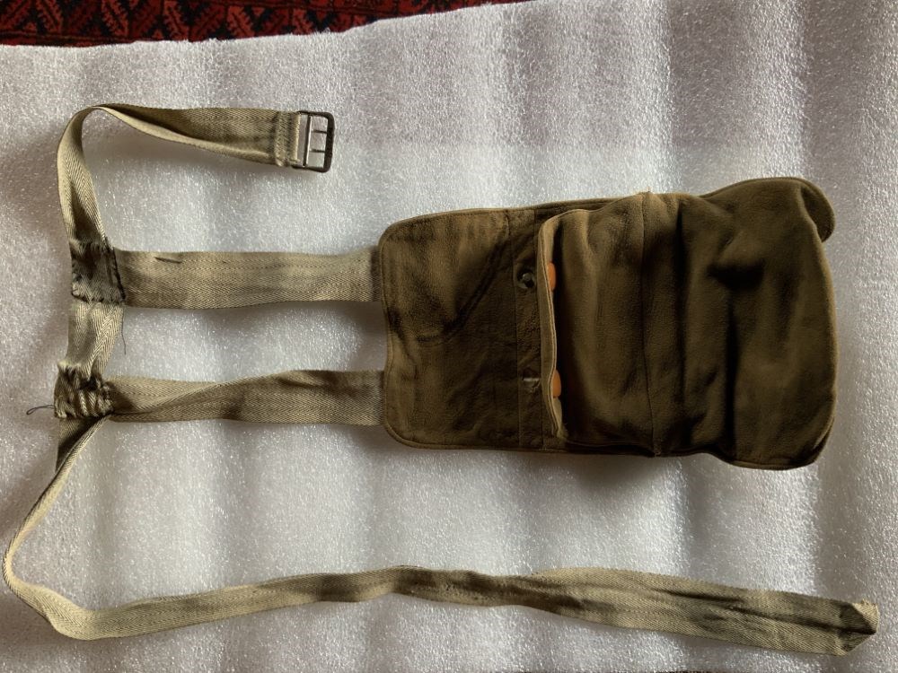
- Description
- A brown suede purse which hangs by two straps from a fabric belt. There is a small money holder with a metal frame that fits inside a pocket. The money holder fastens with two snaps. The lining of the purse is stamped with a patent note.
1 image
- Title
- Purse
- Date
- 1890 – 1910
- Material
- metal; skin; fibre
- Dimensions
- 24.0 x 1.0 x 14.5 cm
- Description
- A brown suede purse which hangs by two straps from a fabric belt. There is a small money holder with a metal frame that fits inside a pocket. The money holder fastens with two snaps. The lining of the purse is stamped with a patent note.
- Subject
- tourism
- Credit
- Gift of Pearl Evelyn Moore, Banff, 1979
- Catalogue Number
- 103.08.0161
Images
This material is presented as originally created; it may contain outdated cultural descriptions and
potentially offensive content.
Read more.