Narrow Results By
[Antarctic Regions]
https://archives.whyte.org/en/permalink/catalogue24849
- Medium
- Library - Maps and blueprints (unannotated; published)
- Map
- Published Date
- 1932
- Publisher
- National Geographic Society
- Call Number
- C13-10.1
- Publisher
- National Geographic Society
- Published Date
- 1932
- Scale
- 252.2 miles to 1 inch
- Subjects
- Antarctic Regions
- Accession Number
- 400
- Call Number
- C13-10.1
- Collection
- Archives Library
This material is presented as originally created; it may contain outdated cultural descriptions and
potentially offensive content.
Read more.
- Medium
- Library - Maps and blueprints (unannotated; published)
- Map
- Published Date
- 1933
- Publisher
- National Geographic Society
- Call Number
- C13-8.1
- Publisher
- National Geographic Society
- Published Date
- 1933
- Scale
- 237 miles to 1 inch
- Subjects
- Asia
- Accession Number
- 400
- Call Number
- C13-8.1
- Collection
- Archives Library
This material is presented as originally created; it may contain outdated cultural descriptions and
potentially offensive content.
Read more.
[Atlantic Ocean]
https://archives.whyte.org/en/permalink/catalogue24848
- Medium
- Library - Maps and blueprints (unannotated; published)
- Map
- Published Date
- 1939
- Publisher
- National Geographic Society
- Call Number
- C13-9.1
- Publisher
- National Geographic Society
- Published Date
- 1939
- Scale
- 316 miles to 1 inch
- Subjects
- Atlantic Ocean
- Accession Number
- 400
- Call Number
- C13-9.1
- Collection
- Archives Library
This material is presented as originally created; it may contain outdated cultural descriptions and
potentially offensive content.
Read more.
Automobile Road Map of Alberta
https://archives.whyte.org/en/permalink/catalogue24397
- Medium
- Library - Maps and blueprints (unannotated; published)
- Map
- Published Date
- 1939
- Publisher
- Alberta Motor Association
- Call Number
- C9-1.8
- Publisher
- Alberta Motor Association
- Published Date
- 1939
- Scale
- Scale: 17 1/2 miles to the inch
- Subjects
- Alberta-Highways
- Accession Number
- 2511
- 2933
- Call Number
- C9-1.8
- Collection
- Archives Library
This material is presented as originally created; it may contain outdated cultural descriptions and
potentially offensive content.
Read more.
Automobile Road Map of Alberta
https://archives.whyte.org/en/permalink/catalogue24398
- Medium
- Library - Maps and blueprints (unannotated; published)
- Map
- Published Date
- 1939
- Publisher
- Alberta Motor Association
- Call Number
- C9-1.8
- Publisher
- Alberta Motor Association
- Published Date
- 1939
- Scale
- Scale: 17 1/2 miles to the inch
- Subjects
- Alberta-Highways
- Accession Number
- 2511
- 2933
- Call Number
- C9-1.8
- Collection
- Archives Library
This material is presented as originally created; it may contain outdated cultural descriptions and
potentially offensive content.
Read more.
Banff National Park, Yoho Park and Kootenay Park
https://archives.whyte.org/en/permalink/catalogue21448
- Medium
- Library - Maps and blueprints (unannotated; published)
- Map
- Published Date
- 1930
- Publisher
- C.P.R.
- Call Number
- C3-6.3(b)
- Publisher
- C.P.R.
- Published Date
- 1930
- Physical Description
- Colour
- Subjects
- Canadian Rockies
- Notes
- Panoramic map showing main and branch lines of C.P.R. Railway
- Accession Number
- 1230
- Call Number
- C3-6.3(b)
- Collection
- Archives Library
This material is presented as originally created; it may contain outdated cultural descriptions and
potentially offensive content.
Read more.
- Medium
- Library - Maps and blueprints (unannotated; published)
- Map
- Published Date
- 1932
- Publisher
- Department of the Interior
- Call Number
- C2-1.1
- Publisher
- Department of the Interior
- Published Date
- 1932
- Physical Description
- 1 map : col
- Scale
- Scale: 3 miles : 1 inch
- Relief: Contour interval 250'
- Subjects
- Banff National Park
- Accession Number
- 400 (4 maps)
- 1003
- 2684
- Call Number
- C2-1.1
- Collection
- Archives Library
This material is presented as originally created; it may contain outdated cultural descriptions and
potentially offensive content.
Read more.
[Banff Townsite]
https://archives.whyte.org/en/permalink/catalogue23270
- Medium
- Library - Maps and blueprints (unannotated; published)
- Map
- Published Date
- June, 1930
- Publisher
- Winnipeg: Western Canada Insurance Underwriters Ass'n
- Call Number
- C4-1.14, 1930
- Publisher
- Winnipeg: Western Canada Insurance Underwriters Ass'n
- Published Date
- June, 1930
- Scale
- Scale: 1"-400'
- Subjects
- Banff townsite
- Notes
- 10 sheets of maps showing Business Lots, Recreation Areas, Population, Schools of Banff townsite in 1930
- See also: C4-1.14(a)
- Fire insurance map
- Accession Number
- 400
- Call Number
- C4-1.14, 1930
- Collection
- Archives Library
This material is presented as originally created; it may contain outdated cultural descriptions and
potentially offensive content.
Read more.
[Bearberry 820/15 West, Alberta]
https://archives.whyte.org/en/permalink/catalogue23487
- Medium
- Library - Maps and blueprints (unannotated; published)
- Map
- Published Date
- 1937
- Publisher
- Dept. of Mines and Technical Surveys
- Call Number
- NTS
- 820/15W
- Publisher
- Dept. of Mines and Technical Surveys
- Published Date
- 1937
- Physical Description
- 1 map : black and white
- Scale
- Scale: 1:50,000
- Relief: Contour interval 100'
- Notes
- National Topographic System
- Call Number
- NTS
- 820/15W
- Collection
- Archives Library
This material is presented as originally created; it may contain outdated cultural descriptions and
potentially offensive content.
Read more.
[Bragg Creek 82J/15 East, Alberta]
https://archives.whyte.org/en/permalink/catalogue23517
- Medium
- Library - Maps and blueprints (unannotated; published)
- Map
- Published Date
- 1939
- Publisher
- Dept. of Mines and Technical Surveys
- Call Number
- NTS
- 82J/15E
- Publisher
- Dept. of Mines and Technical Surveys
- Published Date
- 1939
- Physical Description
- 1 map : black and white
- Scale
- Scale: 1:50,000
- Relief: Contour interval 100'
- Subjects
- Bragg Creek
- Alberta
- Notes
- National Topographic System
- Call Number
- NTS
- 82J/15E
- Collection
- Archives Library
This material is presented as originally created; it may contain outdated cultural descriptions and
potentially offensive content.
Read more.
(Brule Lake-Athabasca River-J.N.P.)
https://archives.whyte.org/en/permalink/catalogue24510
- Medium
- Library - Maps and blueprints (unannotated; published)
- Map
- Published Date
- December 4, 1934
- Publisher
- Department of the Interior
- Call Number
- C9-7.49
- Publisher
- Department of the Interior
- Published Date
- December 4, 1934
- Physical Description
- 1 map : black and white
- Scale
- 40 chains: 1 inch
- Accession Number
- SG7500
- Call Number
- C9-7.49
- Collection
- Archives Library
This material is presented as originally created; it may contain outdated cultural descriptions and
potentially offensive content.
Read more.
[Canada Railway map] Southeastern Canada
https://archives.whyte.org/en/permalink/catalogue24552
- Medium
- Library - Maps and blueprints (unannotated; published)
- Map
- Published Date
- 1930
- Call Number
- C11-3.1
- Published Date
- 1930
- Scale
- Scale: 100 miles - 1 inch
- Subjects
- Canada
- Railway map
- Notes
- Railway map showing CNR, CPR and other Railways, in operation and under construction in 1930
- Accession Number
- 400
- Call Number
- C11-3.1
- Collection
- Archives Library
This material is presented as originally created; it may contain outdated cultural descriptions and
potentially offensive content.
Read more.
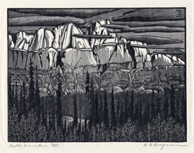
Castle Mountain
https://archives.whyte.org/en/permalink/artifactbeh.04.04
- Date
- 1931
- Medium
- woodblock on rice paper
- Catalogue Number
- BeH.04.04
- Description
- A black and white engraving of Castle Mountain. The foreground is a dense forest with a slight clearing of brush at center of image.The forest ends at slopes up an embankment. The embankment has water pathways, leading in a downward pattern. The mountain rises from the embankment to a cloudy sky. T…
1 image
- Title
- Castle Mountain
- Date
- 1931
- Medium
- woodblock on rice paper
- Dimensions
- 24.8 cm x 33 cm cm
- Description
- A black and white engraving of Castle Mountain. The foreground is a dense forest with a slight clearing of brush at center of image.The forest ends at slopes up an embankment. The embankment has water pathways, leading in a downward pattern. The mountain rises from the embankment to a cloudy sky. There is a red pencilled number “758” in the bottom lhc.
- Subject
- landscape
- mountain
- H. E. Bergman
- Credit
- Gift of Karen Paul, Calgary, 2010
- Catalogue Number
- BeH.04.04
Images
This material is presented as originally created; it may contain outdated cultural descriptions and
potentially offensive content.
Read more.
Completion of Jasper Highway
https://archives.whyte.org/en/permalink/catalogue24288
- Medium
- Library - Maps and blueprints (unannotated; published)
- Map
- Published Date
- 1939
- Publisher
- Department of Mines and Resources
- Call Number
- C2-1.2
- Publisher
- Department of Mines and Resources
- Published Date
- 1939
- Physical Description
- 1 map : col
- Scale
- Scale: 3 miles : 1 inch
- Relief: Contour interval 250'
- Subjects
- Banff National Park
- Accession Number
- 400
- 626 Deaccessioned (2)
- 3349 Deaccessioned
- Call Number
- C2-1.2
- Collection
- Archives Library
This material is presented as originally created; it may contain outdated cultural descriptions and
potentially offensive content.
Read more.
[Fallentimber 820/10 East, Alberta]
https://archives.whyte.org/en/permalink/catalogue23610
- Medium
- Library - Maps and blueprints (unannotated; published)
- Map
- Published Date
- 1937
- Publisher
- Dept. of Mines and Technical Surveys
- Call Number
- NTS
- 820/10E
- Publisher
- Dept. of Mines and Technical Surveys
- Published Date
- 1937
- Physical Description
- 1 map : black and white
- Scale
- Scale: 1:50,000
- Relief: Contour interval 100'
- Subjects
- Fallentimber
- Alberta
- Notes
- National Topographic System
- Call Number
- NTS
- 820/10E
- Collection
- Archives Library
This material is presented as originally created; it may contain outdated cultural descriptions and
potentially offensive content.
Read more.
[Fallentimber 820/10 West, Alberta]
https://archives.whyte.org/en/permalink/catalogue23611
- Medium
- Library - Maps and blueprints (unannotated; published)
- Map
- Published Date
- 1937
- Publisher
- Dept. of Mines and Technical Surveys
- Call Number
- NTS
- 820/10W
- Publisher
- Dept. of Mines and Technical Surveys
- Published Date
- 1937
- Physical Description
- 1 map : black and white
- Scale
- Scale: 1:50,000
- Relief: Contour interval 100'
- Subjects
- Fallentimber
- Alberta
- Notes
- National Topographic System
- Call Number
- NTS
- 820/10W
- Collection
- Archives Library
This material is presented as originally created; it may contain outdated cultural descriptions and
potentially offensive content.
Read more.
[Fitzgerald, Alberta] Topographical sruvey
https://archives.whyte.org/en/permalink/catalogue15488
- Medium
- Library - Maps and blueprints (unannotated; published)
- Map
- Published Date
- 1930
- Publisher
- Dept. of the Interior
- Call Number
- c9-2.2
- Publisher
- Dept. of the Interior
- Published Date
- 1930
- Physical Description
- 1 map : col
- Scale
- 4 miles : 1 inch
- Relief: spot heights
- Subjects
- Lethbridge Sheet
- Accession Number
- 400
- Call Number
- c9-2.2
- Collection
- Archives Library
This material is presented as originally created; it may contain outdated cultural descriptions and
potentially offensive content.
Read more.
Fond-du-lac, Saskatchewan
https://archives.whyte.org/en/permalink/catalogue24582
- Medium
- Library - Maps and blueprints (unannotated; published)
- Map
- Published Date
- 1935
- Publisher
- Department of the Interior
- Call Number
- C11-6.4
- Publisher
- Department of the Interior
- Published Date
- 1935
- Scale
- 4 miles - 1 inch
- Subjects
- Canada - Praririe Region
- Notes
- Topographical Survey
- Accession Number
- 400
- Call Number
- C11-6.4
- Collection
- Archives Library
This material is presented as originally created; it may contain outdated cultural descriptions and
potentially offensive content.
Read more.
[Glacier Park]
https://archives.whyte.org/en/permalink/catalogue23224
- Medium
- Library - Maps and blueprints (unannotated; published)
- Map
- Published Date
- 1934
- Publisher
- Dept. of the Interior
- Call Number
- C2-7.5
- Publisher
- Dept. of the Interior
- Published Date
- 1934
- Scale
- Scale: 1" : 2 miles
- Contour Interval 200'
- Subjects
- Glacier National Park
- Accession Number
- 718
- Call Number
- C2-7.5
- Collection
- Archives Library
This material is presented as originally created; it may contain outdated cultural descriptions and
potentially offensive content.
Read more.
- Date
- 1931
- Medium
- woodblock on rice paper
- Catalogue Number
- BeH.04.03
- Description
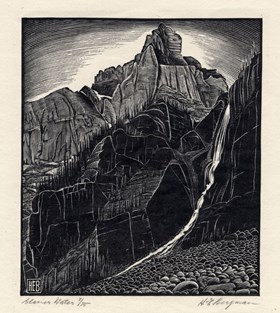
- A black and white woodblock print in which a mountain dominates. On the lower right there are rocks and boulders to the left the lower part of the mountain face. The mountain forms a peak on top with sky behind. On viewer’s right a glacial waterfall flows down the rockwall. Pencil script lhc: Glac…
1 image
- Title
- Glacier Water
- Date
- 1931
- Medium
- woodblock on rice paper
- Dimensions
- 13.7cm x 11.9 cm cm
- Description
- A black and white woodblock print in which a mountain dominates. On the lower right there are rocks and boulders to the left the lower part of the mountain face. The mountain forms a peak on top with sky behind. On viewer’s right a glacial waterfall flows down the rockwall. Pencil script lhc: Glacial Water 7/75, pencil script rhc: H.E. Bergman
- Subject
- landscape
- mountain
- H.E. Bergman
- Credit
- Gift of Karen Paul, Calgary, 2010
- Catalogue Number
- BeH.04.03
Images
This material is presented as originally created; it may contain outdated cultural descriptions and
potentially offensive content.
Read more.


