Narrow Results By
- Library - Book (including soft-cover and pamphlets) 1306
- Map 275
- Library - Maps and blueprints (unannotated; published)
- Library - Moving image (includes film and digital video - published) 39
- Library - Postcard 35
- Beaded Necklace 16
- Beaded Belt
- Doll 13
- Library - Periodical 13
- Dance Regalia 11
- War Bonnet Headdress 11
- Beaded Moccasins 10
Alberta and British Columbia [road map]
https://archives.whyte.org/en/permalink/catalogue24411
- Medium
- Library - Maps and blueprints (unannotated; published)
- Map
- Published Date
- 1953
- Publisher
- Imperial Esso Touring Service
- Call Number
- C9-1.21
- Publisher
- Imperial Esso Touring Service
- Published Date
- 1953
- Physical Description
- 8 maps on 1 sheet : col
- Scale
- Scale: 1 inch = ca 30 1/2 miles
- Subjects
- Alberta
- British Columbia
- Notes
- Contents : Alberta. -- British Columbia
- Insets feature maps of Edmonton, Calgary, Vancouver, Victoria, Alaska Highway, Fraser Valley. Cover features Waterton Lakes with Prince of Wales Hotel
- Accession Number
- 6787
- Call Number
- C9-1.21
- Collection
- Archives Library
This material is presented as originally created; it may contain outdated cultural descriptions and
potentially offensive content.
Read more.
Alberta endangered wilderness / Alberta Wilderness Association
https://archives.whyte.org/en/permalink/catalogue21409
- Medium
- Library - Maps and blueprints (unannotated; published)
- Map
- Published Date
- 1990
- Publisher
- [Calgary?] : The Association
- Call Number
- C9-5.19
- Publisher
- [Calgary?] : The Association
- Published Date
- 1990
- Physical Description
- 1 map : col
- Accession Number
- SL 94B24KXP
- Call Number
- C9-5.19
- Collection
- Archives Library
This material is presented as originally created; it may contain outdated cultural descriptions and
potentially offensive content.
Read more.
[Alberta] Resources and Development
https://archives.whyte.org/en/permalink/catalogue24423
- Medium
- Library - Maps and blueprints (unannotated; published)
- Map
- Published Date
- 1952
- Publisher
- A. Shnitka, Qheens' Printer for Alberta
- Call Number
- C9-5.1
- Publisher
- A. Shnitka, Qheens' Printer for Alberta
- Published Date
- 1952
- Physical Description
- 1 map : col
- Scale
- Scale: 1 inch: 20 miles
- Subjects
- Alberta
- Accession Number
- 372
- Call Number
- C9-5.1
- Collection
- Archives Library
This material is presented as originally created; it may contain outdated cultural descriptions and
potentially offensive content.
Read more.
Alberta road map
https://archives.whyte.org/en/permalink/catalogue24410
- Medium
- Library - Maps and blueprints (unannotated; published)
- Map
- Published Date
- 1990
- Publisher
- Edmonton : Alberta Tourism
- Call Number
- C9-1.20
- Publisher
- Edmonton : Alberta Tourism
- Published Date
- 1990
- Physical Description
- 14 maps on 1 sheet
- Scale
- Scale: 1:500,000
- Subjects
- Alberta
- Notes
- Province of Alberta, Canada 1990 official road map
- Cover title: Alberta road map
- Maps of principal towns and cities on reverse
- Info file transfer
- Call Number
- C9-1.20
- Collection
- Archives Library
This material is presented as originally created; it may contain outdated cultural descriptions and
potentially offensive content.
Read more.
[Anahim Lake 93C, B.C.]
https://archives.whyte.org/en/permalink/catalogue24005
- Medium
- Library - Maps and blueprints (unannotated; published)
- Map
- Published Date
- 1955
- Publisher
- Dept. of Mines and Technical Surveys
- Call Number
- NTS
- 93C
- Publisher
- Dept. of Mines and Technical Surveys
- Published Date
- 1955
- Physical Description
- 1 map : col
- Scale
- Scale: 1:250,000
- Relief: Contour interval 500 ft.
- Subjects
- Anahim Lake
- British Columbia
- Accession Number
- 3000
- Call Number
- NTS
- 93C
- Collection
- Archives Library
This material is presented as originally created; it may contain outdated cultural descriptions and
potentially offensive content.
Read more.
Athabasca Falls : Improvement District 12 Alberta
https://archives.whyte.org/en/permalink/catalogue24240
- Medium
- Library - Maps and blueprints (unannotated; published)
- Map
- Published Date
- 1996
- Publisher
- Ottawa : Natural Resources Canada
- Edition
- 3 ed
- Call Number
- NTS
- 83 C12
- Edition
- 3 ed
- Publisher
- Ottawa : Natural Resources Canada
- Published Date
- 1996
- Physical Description
- 1 map : col
- Scale
- Scale: 1:50,000
- Relief: contour interval 20 metres below 2000 metres, 40 metres above 2000 metres
- Accession Number
- 30500 3.2.98
- Call Number
- NTS
- 83 C12
- Collection
- Archives Library
This material is presented as originally created; it may contain outdated cultural descriptions and
potentially offensive content.
Read more.
Athabasca Pass : British Columbia Alberta Colombie-Britannique Alberta
https://archives.whyte.org/en/permalink/catalogue24259
- Medium
- Library - Maps and blueprints (unannotated; published)
- Map
- Published Date
- 1996
- Publisher
- Ottawa : Natural Resources Canada
- Edition
- 3 ed
- Call Number
- NTS
- 83 D8
- Edition
- 3 ed
- Publisher
- Ottawa : Natural Resources Canada
- Published Date
- 1996
- Physical Description
- 1 map : col
- Scale
- Scale: 1:50,000
- Relief: Contour interval 40 metres
- Accession Number
- 29500 4.2.97
- Call Number
- NTS
- 83 D8
- Collection
- Archives Library
This material is presented as originally created; it may contain outdated cultural descriptions and
potentially offensive content.
Read more.
[Athabaska Falls 83C/12, Alberta]
https://archives.whyte.org/en/permalink/catalogue23455
- Medium
- Library - Maps and blueprints (unannotated; published)
- Map
- Published Date
- 1955
- Publisher
- Dept. of National Defence
- Call Number
- NTS
- 83C/12
- Publisher
- Dept. of National Defence
- Published Date
- 1955
- Physical Description
- 1 map : col
- Scale
- Scale: 1:50,000
- Relief: Contour interval 100'
- Subjects
- Athabaska Falls
- Alberta
- Notes
- National Topographic System
- Call Number
- NTS
- 83C/12
- Collection
- Archives Library
This material is presented as originally created; it may contain outdated cultural descriptions and
potentially offensive content.
Read more.
[Atlin 104N, B.C.]
https://archives.whyte.org/en/permalink/catalogue24007
- Medium
- Library - Maps and blueprints (unannotated; published)
- Map
- Published Date
- 1954
- Publisher
- Dept. of Mines and Technical Surveys
- Call Number
- NTS
- 104N
- Publisher
- Dept. of Mines and Technical Surveys
- Published Date
- 1954
- Physical Description
- 1 map : col
- Scale
- Scale: 1:250,000
- Relief: Contour interval 500 ft.
- Subjects
- Atlin
- British Columbia
- Notes
- National Topographic System
- Accession Number
- 3000
- Call Number
- NTS
- 104N
- Collection
- Archives Library
This material is presented as originally created; it may contain outdated cultural descriptions and
potentially offensive content.
Read more.
[Banff 820/4 East, Alta.-B.C.]
https://archives.whyte.org/en/permalink/catalogue23479
- Medium
- Library - Maps and blueprints (unannotated; published)
- Map
- Published Date
- 1959
- Publisher
- Dept. of Mines and Technical Surveys
- Call Number
- NTS
- 820/4E
- Publisher
- Dept. of Mines and Technical Surveys
- Published Date
- 1959
- Physical Description
- 1 map : col
- Scale
- Scale: 1:50,000
- Relief: Contour interval 100 ft.
- Subjects
- Banff
- Alberta/British Columbia
- Notes
- National Topographic System
- Dup in map room
- Dup in research room
- Accession Number
- 718
- 3000
- Call Number
- NTS
- 820/4E
- Collection
- Archives Library
This material is presented as originally created; it may contain outdated cultural descriptions and
potentially offensive content.
Read more.
[Banff 820/4 West, Alta.-B.C.]
https://archives.whyte.org/en/permalink/catalogue23480
- Medium
- Library - Maps and blueprints (unannotated; published)
- Map
- Published Date
- 1959
- Publisher
- Dept. of Mines and Technical Surveys
- Call Number
- NTS
- 829/4W
- Publisher
- Dept. of Mines and Technical Surveys
- Published Date
- 1959
- Physical Description
- 1 map : col
- Scale
- Scale: 1:50,000
- Relief: Contour interval 100 ft.
- Subjects
- Banff
- Alberta/British Columbia
- Notes
- National Topographic System
- Dup in map room
- Dup in research room
- Accession Number
- 718
- 3000
- Call Number
- NTS
- 829/4W
- Collection
- Archives Library
This material is presented as originally created; it may contain outdated cultural descriptions and
potentially offensive content.
Read more.
- Medium
- Library - Maps and blueprints (unannotated; published)
- Map
- Published Date
- 1955
- Publisher
- Department of Mines and Technical Surveys
- Call Number
- C2-1.4
- Publisher
- Department of Mines and Technical Surveys
- Published Date
- 1955
- Physical Description
- 1 map : col
- Scale
- Scale: 1 in. to 3 miles
- Relief: Contour interval 250'
- Subjects
- Banff National Park
- Accession Number
- 400
- 673
- 3000 Deaccessioned (2)
- 3349 Deaccessioned
- Call Number
- C2-1.4
- Collection
- Archives Library
This material is presented as originally created; it may contain outdated cultural descriptions and
potentially offensive content.
Read more.
- Medium
- Library - Maps and blueprints (unannotated; published)
- Map
- Published Date
- 1955, 1974
- Publisher
- Department of Mines and Technical Surveys
- Edition
- interim corrections 1974
- Call Number
- C2-1.4 (a)
- Edition
- interim corrections 1974
- Publisher
- Department of Mines and Technical Surveys
- Published Date
- 1955, 1974
- Physical Description
- 1 map : col
- Scale
- Scale: 1 in. to 3 miles
- Relief: Contour interval 250 ft.
- Accession Number
- 5319
- 7000 Deaccessioned
- Call Number
- C2-1.4 (a)
- Collection
- Archives Library
This material is presented as originally created; it may contain outdated cultural descriptions and
potentially offensive content.
Read more.
[Banff Townsite]
https://archives.whyte.org/en/permalink/catalogue23269
- Medium
- Library - Maps and blueprints (unannotated; published)
- Map
- Published Date
- November, 1955
- Publisher
- Winnipeg: Western Canada Insurance Underwriters Ass'n
- Call Number
- C4-1.14(a), 1955
- Publisher
- Winnipeg: Western Canada Insurance Underwriters Ass'n
- Published Date
- November, 1955
- Scale
- Scale: 1"-800'
- Subjects
- Banff townsite
- Notes
- 4 sheets of maps showing Business Lots, Recreation Areas, Population, Schools of Banff townsite in 1955.
- See also: C4-1.14
- Fire insurance map
- Accession Number
- 2678
- Call Number
- C4-1.14(a), 1955
- Collection
- Archives Library
This material is presented as originally created; it may contain outdated cultural descriptions and
potentially offensive content.
Read more.
Banff/Canmore
https://archives.whyte.org/en/permalink/catalogue24320
- Medium
- Library - Maps and blueprints (unannotated; published)
- Map
- Published Date
- 1990
- Publisher
- Stanley Associates Engineering - Calgary
- Call Number
- C6-4.3k
- Publisher
- Stanley Associates Engineering - Calgary
- Published Date
- 1990
- Physical Description
- 1 map : col
- Scale
- 1 : 50,000
- Series
- Tourism oriented planning series
- Accession Number
- 5786
- Call Number
- C6-4.3k
- Collection
- Archives Library
This material is presented as originally created; it may contain outdated cultural descriptions and
potentially offensive content.
Read more.
Banff/Canmore
https://archives.whyte.org/en/permalink/catalogue23387
- Medium
- Library - Maps and blueprints (unannotated; published)
- Map
- Published Date
- 1990
- Publisher
- Stanley Associates Engineering - Calgary
- Call Number
- C6-4.3k
- Publisher
- Stanley Associates Engineering - Calgary
- Published Date
- 1990
- Physical Description
- 1 map : col
- Scale
- 1 : 50,000
- Series
- Tourism oriented planning series
- Accession Number
- 5786
- Call Number
- C6-4.3k
- Collection
- Archives Library
This material is presented as originally created; it may contain outdated cultural descriptions and
potentially offensive content.
Read more.
Barrier Mountain : Alberta west of fifth meridian ouest du cinquieme meridien
https://archives.whyte.org/en/permalink/catalogue24899
- Medium
- Library - Maps and blueprints (unannotated; published)
- Map
- Published Date
- 1996
- Publisher
- Ottawa : Natural Resources Canada
- Edition
- 3 ed
- Call Number
- NTS
- 82 O12
- Edition
- 3 ed
- Publisher
- Ottawa : Natural Resources Canada
- Published Date
- 1996
- Physical Description
- 1 map : col
- Scale
- Scale: 1:50,000
- Relief - contour interval 40 metres
- Accession Number
- 30500 3.2.98
- Call Number
- NTS
- 82 O12
- Collection
- Archives Library
This material is presented as originally created; it may contain outdated cultural descriptions and
potentially offensive content.
Read more.
- Date
- 1950 – 1960
- Material
- skin; glass; metal
- Catalogue Number
- 103.07.0009
- Description
- A woman's beaded belt, worked on harness leather, that fastens with a buckle. The belt has a light blue background with a design in dark blue, red and white beads.
1 image
- Title
- Beaded Belt
- Date
- 1950 – 1960
- Material
- skin; glass; metal
- Dimensions
- 4.4 x 120.0 cm
- Description
- A woman's beaded belt, worked on harness leather, that fastens with a buckle. The belt has a light blue background with a design in dark blue, red and white beads.
- Subject
- Indigenous
- Stoney
- decorative
- regalia
- beadwork
- Credit
- Gift of Pearl Evelyn Moore, Banff, 1979
- Catalogue Number
- 103.07.0009
Images

This material is presented as originally created; it may contain outdated cultural descriptions and
potentially offensive content.
Read more.
- Date
- 1955 – 1965
- Material
- glass; skin; fibre
- Catalogue Number
- 103.07.0070
- Description
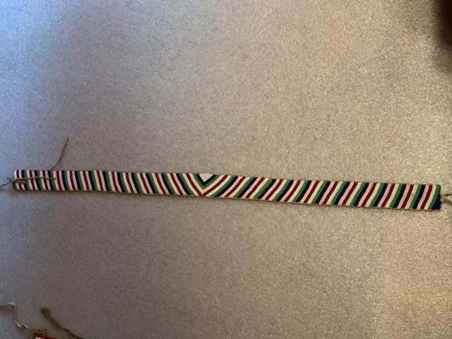
- Completely beaded belt on canvas. Beaded diagonal blue, green, white red stripes along its length, meeting at the middle then reversing the slant. Buckskin ties at each end with two more set in approximately 10 cm form each end, one on underside and one on topside, so that belt overlaps when tied.
1 image
- Title
- Beaded Belt
- Date
- 1955 – 1965
- Material
- glass; skin; fibre
- Dimensions
- 5.0 x 92.0 cm
- Description
- Completely beaded belt on canvas. Beaded diagonal blue, green, white red stripes along its length, meeting at the middle then reversing the slant. Buckskin ties at each end with two more set in approximately 10 cm form each end, one on underside and one on topside, so that belt overlaps when tied.
- Credit
- Gift of Catharine Robb Whyte, O. C., Banff, 1979
- Catalogue Number
- 103.07.0070
Images
This material is presented as originally created; it may contain outdated cultural descriptions and
potentially offensive content.
Read more.
- Date
- prior to 1978
- Material
- glass; skin
- Catalogue Number
- 103.07.1049
- Description
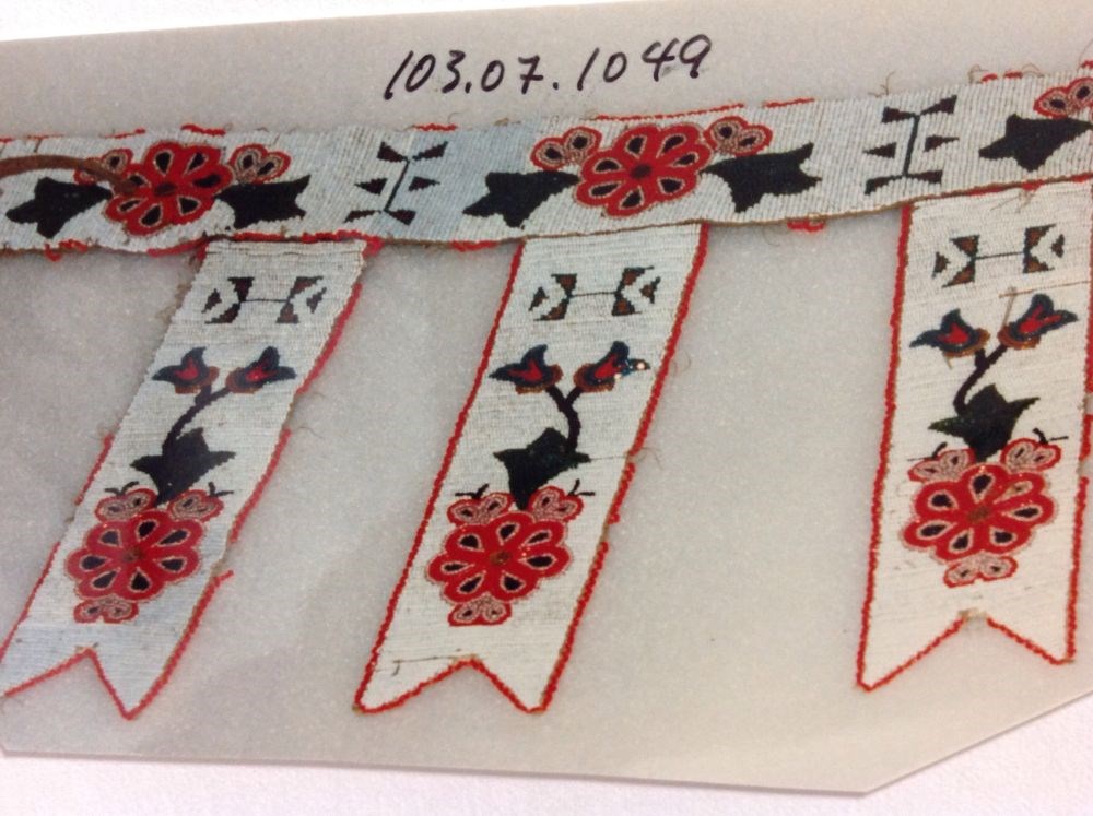
- Beaded belt with three hanging panels. White background with floral motif, red, yellow, green, three on belt with four geometric designs seperating them. Buckskin thongs on ends for tying. Panels have similar floral design with added buds and a geometric chevron design near top.
1 image
- Title
- Beaded Belt
- Date
- prior to 1978
- Material
- glass; skin
- Description
- Beaded belt with three hanging panels. White background with floral motif, red, yellow, green, three on belt with four geometric designs seperating them. Buckskin thongs on ends for tying. Panels have similar floral design with added buds and a geometric chevron design near top.
- Subject
- Indigenous
- regalia
- beadwork
- Credit
- Gift of Catharine Robb Whyte, O. C., Banff, 1970
- Catalogue Number
- 103.07.1049
Images
This material is presented as originally created; it may contain outdated cultural descriptions and
potentially offensive content.
Read more.