Narrow Results By
[Anahim Lake, B.C.] Canada Land Inventory Map, Land capability for wildlife-ungulates
https://archives.whyte.org/en/permalink/catalogue24004
- Medium
- Library - Maps and blueprints (unannotated; published)
- Map
- Published Date
- 1971
- Publisher
- Dept. of Energy, Mines and Resources
- Call Number
- NTS
- 93C
- Publisher
- Dept. of Energy, Mines and Resources
- Published Date
- 1971
- Physical Description
- 1 map : col
- Scale
- Scale: 1:250,000
- Subjects
- Anahim Lake
- British Columbia
- Accession Number
- 4000
- Call Number
- NTS
- 93C
- Collection
- Archives Library
This material is presented as originally created; it may contain outdated cultural descriptions and
potentially offensive content.
Read more.
[Angus Horne Lake 83D/5 B.C.]
https://archives.whyte.org/en/permalink/catalogue23450
- Medium
- Library - Maps and blueprints (unannotated; published)
- Map
- Published Date
- 1972
- Publisher
- Department of Energy, Mines and Resources
- Call Number
- NTS
- 83D/5
- Publisher
- Department of Energy, Mines and Resources
- Published Date
- 1972
- Physical Description
- 1 map : col
- Scale
- Scale: 1:50,000
- Relief: Contour interval 100 ft.
- Subjects
- Angus Horne Lake
- British Columbia
- Notes
- National Topographic System
- Accession Number
- 7000
- Call Number
- NTS
- 83D/5
- Collection
- Archives Library
This material is presented as originally created; it may contain outdated cultural descriptions and
potentially offensive content.
Read more.
[Azure River 83D/12 B.C.]
https://archives.whyte.org/en/permalink/catalogue23458
- Medium
- Library - Maps and blueprints (unannotated; published)
- Map
- Published Date
- 1972
- Publisher
- Department of Energy, Mines and Resources
- Call Number
- NTS
- 83D/12
- Publisher
- Department of Energy, Mines and Resources
- Published Date
- 1972
- Physical Description
- 1 map : col
- Scale
- Scale: 1:50,000
- Relief: Contour interval 100 ft.
- Subjects
- Azure River
- British Columbia
- Notes
- National Topographic System
- Accession Number
- 7000
- 7030
- Call Number
- NTS
- 83D/12
- Collection
- Archives Library
This material is presented as originally created; it may contain outdated cultural descriptions and
potentially offensive content.
Read more.
Banff "active best"
https://archives.whyte.org/en/permalink/descriptions56444
- Part Of
- Douglas Leighton fonds
- Scope & Content
- File consists of photographs compiled by Douglas Leighton for publication. Includes photographs of landscapes, lakes, mountains, hotel, tourists, waterfalls and glaciers.
- Date Range
- 1978
- 1979
- 1984
- 1986 - 1993
- 1995
- 1996
- Reference Code
- V222 / VI / C / 2 / NS - 1 to 155
- Description Level
- 5 / File
- GMD
- Photograph
- Transparency
- Part Of
- Douglas Leighton fonds
- Description Level
- 5 / File
- Fonds Number
- M133
- V222
- Series
- V222 / VI : Publication
- Sous-Fonds
- V222
- Sub-Series
- V222 / VI / C: Compiled for publication
- Accession Number
- 2020.24
- Reference Code
- V222 / VI / C / 2 / NS - 1 to 155
- Date Range
- 1978
- 1979
- 1984
- 1986 - 1993
- 1995
- 1996
- Physical Description
- 155 photographs : col. slides ; 35 mm
- Scope & Content
- File consists of photographs compiled by Douglas Leighton for publication. Includes photographs of landscapes, lakes, mountains, hotel, tourists, waterfalls and glaciers.
- Name Access
- Leighton, Douglas
- Subject Access
- British Columbia
- Geographic Access
- Alberta
- Lake Louise, AB
- Banff National Park
- Banff
- Exshaw
- Canmore
- Language
- English
- Creator
- Douglas Leighton
- Title Source
- Title based on contents of file
- Processing Status
- Processed
This material is presented as originally created; it may contain outdated cultural descriptions and
potentially offensive content.
Read more.
B.C. Highway map
https://archives.whyte.org/en/permalink/catalogue24515
- Medium
- Library - Maps and blueprints (unannotated; published)
- Map
- Published Date
- 1975-76
- Publisher
- Lawson Graphics (Pacific)
- Call Number
- C10-1.4
- Publisher
- Lawson Graphics (Pacific)
- Published Date
- 1975-76
- Scale
- Scale: 1 inch - 34 miles
- Subjects
- British Columbia
- Highways
- Call Number
- C10-1.4
- Collection
- Archives Library
This material is presented as originally created; it may contain outdated cultural descriptions and
potentially offensive content.
Read more.
[Bennington Summit Register]
https://archives.whyte.org/en/permalink/descriptions57730
- Part Of
- Alpine Club of Canada fonds
- Scope & Content
- File consists of a summit record from Bennington Peak produced by the Alpine Club of Canada from around 1970. Entries are illegible due to severe water and mold damage. File: [Bennington Summit Register]
- Date Range
- ca. 1970
- Reference Code
- M200 / V / A / 138
- Description Level
- 5 / File
- GMD
- Textual record
- Organization record
- Part Of
- Alpine Club of Canada fonds
- Description Level
- 5 / File
- Fonds Number
- M200
- V14
- S6
- Series
- M200 / V: Summit Records
- Sous-Fonds
- M200
- Sub-Series
- M200 / V / A: Identified Summit Records
- Accession Number
- accn. 2023.18
- Reference Code
- M200 / V / A / 138
- Responsibility
- Summit Registers and Notes produced by Alpine Club of Canada
- Date Range
- ca. 1970
- Physical Description
- 1 volume 1 cm of textual record
- History / Biographical
- Bennington Peak is located along the Continental Divide/Great Divide along the Alberta/British Columbia provincial border. Bennington Peak is one of the peaks of Mount Fraser and is part of the Bennington Glacier. It is situated on on the border of Jasper National Park, Alberta and Mount Robson Provincial Park, British Columbia.
- Scope & Content
- File consists of a summit record from Bennington Peak produced by the Alpine Club of Canada from around 1970. Entries are illegible due to severe water and mold damage. File: [Bennington Summit Register]
- Notes
- Summit entries are illegible due to severe water and mold damage.
- Name Access
- Alpine Club of Canada
- Subject Access
- Alpine Club of Canada
- British Columbia
- Alberta
- Description and travel
- Mountain
- Mountains
- National parks and reserves
- Provincial parks and reserves
- Record keeping
- Summit
- Geographic Access
- Canada
- Continental Divide
- Great Divide
- Canadian Rocky Mountains
- Alberta
- British Columbia
- Jasper National Park
- Mount Robson Provincial Park
- Mount Fraser
- Bennington Peak
- Access Restrictions
- Restrictions may apply
- Conservation
- Register placed in mylar due to severe mold, water and rust damage. Entries in register are illegible due to damage.
- Related Material
- M235
- Biographical Source Notes
- Peak Finder: Bennington Peak, Canadian Rockies Database: https://cdnrockiesdatabases.ca/peaks/111
- Title Source
- Title based on contents of file
- Processing Status
- Processed
This material is presented as originally created; it may contain outdated cultural descriptions and
potentially offensive content.
Read more.
[British Columbia Highway] Highway map
https://archives.whyte.org/en/permalink/catalogue24514
- Medium
- Library - Maps and blueprints (unannotated; published)
- Map
- Published Date
- 1975-76
- Publisher
- Grant-Mann Lithographers Ltd.
- Call Number
- C10-1.3
- Publisher
- Grant-Mann Lithographers Ltd.
- Published Date
- 1975-76
- Scale
- Scale: 1 inch - 34 miles
- Subjects
- British Columbia
- Highways
- Call Number
- C10-1.3
- Collection
- Archives Library
This material is presented as originally created; it may contain outdated cultural descriptions and
potentially offensive content.
Read more.
[Bute Inlet, B.C.] Canada Land Inventory Map, Land capability for wildlife-ungulates
https://archives.whyte.org/en/permalink/catalogue24016
- Medium
- Library - Maps and blueprints (unannotated; published)
- Map
- Published Date
- 1971
- Publisher
- Dept. of Energy, Mines and Resouces
- Call Number
- NTS
- 92K
- Publisher
- Dept. of Energy, Mines and Resouces
- Published Date
- 1971
- Physical Description
- 1 map : col
- Scale
- Scale: 1:250,000
- Subjects
- Bute Inlet
- British Columbia
- Accession Number
- 4000
- Call Number
- NTS
- 92K
- Collection
- Archives Library
This material is presented as originally created; it may contain outdated cultural descriptions and
potentially offensive content.
Read more.
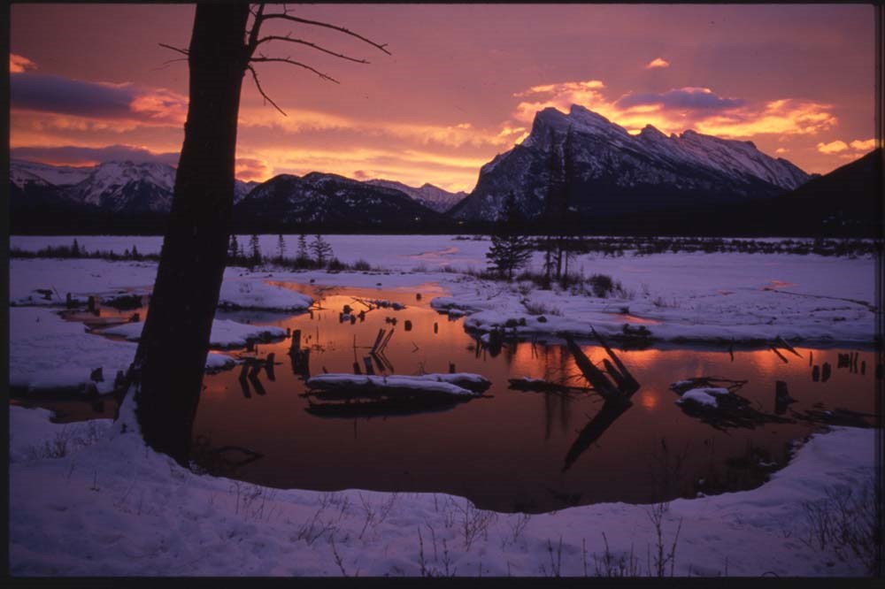
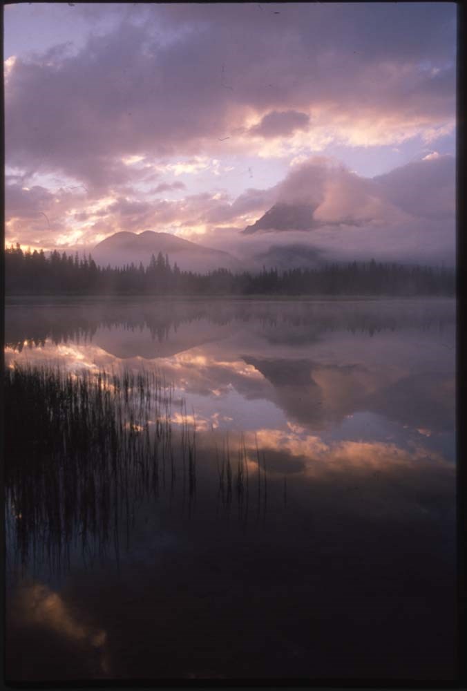
Canadian Rockies and other "active best"
https://archives.whyte.org/en/permalink/descriptions56446
- Part Of
- Douglas Leighton fonds
- Scope & Content
- File consists of photographs compiled by Douglas Leighton for publication. Includes photographs of landscapes, cityscapes, lakes, mountains, hotel, tourists, plants, waterfalls and glaciers.
- Date Range
- 1978
- 1981 - 1983
- 1987
- 1988
- 1990
- 1993 - 1995
- 1997
- 1998
- 2003
- 2006
- 2007
- Reference Code
- V222 / VI / C / 4 / NS - 1 to 119
- Description Level
- 5 / File
- GMD
- Photograph
- Transparency
4 images
- Part Of
- Douglas Leighton fonds
- Description Level
- 5 / File
- Fonds Number
- M133
- V222
- Series
- V222 / VI : Publication
- Sous-Fonds
- V222
- Sub-Series
- V222 / VI / C: Compiled for publication
- Accession Number
- 2020.24
- Reference Code
- V222 / VI / C / 4 / NS - 1 to 119
- Date Range
- 1978
- 1981 - 1983
- 1987
- 1988
- 1990
- 1993 - 1995
- 1997
- 1998
- 2003
- 2006
- 2007
- Physical Description
- 119 photographs : col. slides ; 35 mm
- Scope & Content
- File consists of photographs compiled by Douglas Leighton for publication. Includes photographs of landscapes, cityscapes, lakes, mountains, hotel, tourists, plants, waterfalls and glaciers.
- Name Access
- Leighton, Douglas
- Subject Access
- British Columbia
- Geographic Access
- Alberta
- British Columbia
- Banff National Park
- Banff
- Calgary, AB
- Edmonton, AB
- Kootenay, BC
- Yoho National Park
- Jasper National Park
- Cranbrook, BC
- Vancouver, BC
- Language
- English
- Creator
- Douglas Leighton
- Title Source
- Title based on contents of file
- Processing Status
- Processed
Images
This material is presented as originally created; it may contain outdated cultural descriptions and
potentially offensive content.
Read more.
Canadian Rockies Climbing Report
https://archives.whyte.org/en/permalink/catalogue15166
- Medium
- Library - Book (including soft-cover and pamphlets)
- Published Date
- June 21 1972
- Call Number
- F1090 J37
- Responsibility
- Japanese University student climbing group
- Published Date
- June 21 1972
- Physical Description
- 51 pages, ill.
- Notes
- Report of Japanese University students of their trip to Western Canada (Alberta, BC) and their climbing expepditions in the Rocky Mountains. Includes articles written by students about their experiences, a full itinerary of their trip, diagrams of Columbia Icefield traverse, photos and cost of trip.
- Article about Banff
- Call Number
- F1090 J37
- Collection
- Alpine Club of Canada Library
This material is presented as originally created; it may contain outdated cultural descriptions and
potentially offensive content.
Read more.
Cariboo yarns
https://archives.whyte.org/en/permalink/catalogue20065
- Medium
- Library - Book (including soft-cover and pamphlets)
- Published Date
- 1973
- Author
- Lindsay, F.W.
- Publisher
- Quesnel, B.C., [publisher not identified]
- Call Number
- 08.2 L64c
- Author
- Lindsay, F.W.
- Responsibility
- F.W. Lindsay
- Publisher
- Quesnel, B.C., [publisher not identified]
- Published Date
- 1973
- Physical Description
- 64 pages illustrations 24 cm
- Subjects
- British Columbia
- Gold rush
- Cariboo Mountains
- Abstract
- Pertains to a collection of informal stories about Cariboo country during, prior to and after the gold rush. The publication has been dedicated to the prospectors themselves. Cariboo yarns was created in an attempt to share the stories of the men who made the history during the Cariboo gold rush. Through the use of diaries and other archival materials, readers can expect to learn more about the gold rush from the accounts of men who experienced it firsthand.
- Accession Number
- 3069 a
- Call Number
- 08.2 L64c
- Collection
- Archives Library
This material is presented as originally created; it may contain outdated cultural descriptions and
potentially offensive content.
Read more.
[Chase 82L/13 B.C.]
https://archives.whyte.org/en/permalink/catalogue23547
- Medium
- Library - Maps and blueprints (unannotated; published)
- Map
- Published Date
- 1973
- Publisher
- Department of Energy, Mines and Resources
- Call Number
- NTS
- 82L/I3
- Publisher
- Department of Energy, Mines and Resources
- Published Date
- 1973
- Physical Description
- 1 map : col
- Scale
- Scale: 1:50,000
- Relief: Contour interval 100 ft.
- Subjects
- Chase
- British Columbia
- Notes
- National Topographic System
- Accession Number
- 7000
- Call Number
- NTS
- 82L/I3
- Collection
- Archives Library
This material is presented as originally created; it may contain outdated cultural descriptions and
potentially offensive content.
Read more.
Come with me to yesterday : tales retold of pioneer days in East Kootenay
https://archives.whyte.org/en/permalink/catalogue20103
- Medium
- Library - Book (including soft-cover and pamphlets)
- Published Date
- 1972
- Author
- Kay, Dave and D.A. MacDonald
- Publisher
- Cranbrook, B.C. : D.A. MacDonald and D. Kay
- Edition
- Augmented ed.
- Call Number
- 08.2 K18c
- Author
- Kay, Dave and D.A. MacDonald
- Responsibility
- Dave Kay and D.A. MacDonald
- Edition
- Augmented ed.
- Publisher
- Cranbrook, B.C. : D.A. MacDonald and D. Kay
- Published Date
- 1972
- Physical Description
- 88 p. : ill., ports. ; 23 cm
- Abstract
- Pertains to a collection of articles pulled from the weekly column of the Cranbrook Courier. The intent behind the publication was to tell the history, and share the stories of those who settled in the East Kootenay area. Readers can expect to receive a personal experience, while learning more about the early settlers of the East Kootenay area.
- Contents
- Foreword (pg. 3)
- Early explorers of East Kootenay (pg. 4)
- Fort Steele in its heyday (pg. 5)
- Christmas at "the Ferry", 1869 (pg. 11)
- Dave Griffith's fireplace (pg. 14)
- Dave Griffith, A wild Horse pioneer (pg. 15)
- The wonders of wild horse (pg. 16)
- Murder on wild horse -
- An interview with Bob Dore (pg. 19)
- Michael Phillipps (pg. 22)
- Blazing the Crows Nest Pass Trail (pg. 23)
- An appreciation (pg. 25)
- The Sinclairs (pg. 27)
- Father Coccola, Early Missionary (pg. 28)
- Building the Dewdney Trail (pg. 32)
- The Galbrath Brothers, John and Robert (pg. 35)
- North West Mounted Police and Sam Steele (pg. 38)
- Steamboating days in East Kootenay (pg. 46)
- On the upper Columbia (pg. 47)
- On the upper Kootenay (pg. 50)
- Steamboating at Bonners Ferry (pg. 54)
- Henry W. Barr (pg. 55)
- The Mathers, another pioneer family (pg. 58)
- N.A. Wallinger (pg. 60)
- Crankbrook's beginnings (pg. 63)
- Henry E. Seelye, Ffirst customs officer (pg. 63)
- The Galbraiths at Crankbook (pg. 64)
- Colonel James Baker (pg. 65)
- V.Hyde Baker (pg. 66)
- First Customs Officers (pg. 68)
- First Buildings (pg. 68)
- Events leading to the discovery of the Sullivan Mine at Kimberley (pg. 72)
- Marysville, "Smelter City" (pg. 75)
- St. Mary's Valley Railroad (pg. 76)
- Marysville's First Dance (pg. 77)
- Perry Creek (pg. 78)
- The New Perry Creek (pg. 80)
- History of Fernie, 1898 to 1902 (pg. 82)
- Wardner, Sawmill Town (pg. 84)
- Francois and Baptiste Morigeau (pg.86)
- Accession Number
- 3069 a
- Call Number
- 08.2 K18c
- Collection
- Archives Library
This material is presented as originally created; it may contain outdated cultural descriptions and
potentially offensive content.
Read more.
[Cottonwood River, B.C.] Canada Land Inventory Map, Land Capability for Forestry
https://archives.whyte.org/en/permalink/catalogue23961
- Medium
- Library - Maps and blueprints (unannotated; published)
- Map
- Published Date
- 1972
- Publisher
- Department of Energy, Mines and Resources
- Call Number
- NTS
- 93G/SE
- Publisher
- Department of Energy, Mines and Resources
- Published Date
- 1972
- Physical Description
- 1 map : col
- Scale
- Scale: 1:125,000
- Subjects
- Cottonwood River
- British Columbia
- Accession Number
- 7000
- Call Number
- NTS
- 93G/SE
- Collection
- Archives Library
This material is presented as originally created; it may contain outdated cultural descriptions and
potentially offensive content.
Read more.
[Cranbrook, B.C.] Canada Land Inventory Map, Land Capability for Forestry
https://archives.whyte.org/en/permalink/catalogue23962
- Medium
- Library - Maps and blueprints (unannotated; published)
- Map
- Published Date
- 1972
- Publisher
- Department of Energy, Mines and Resources
- Call Number
- NTS
- 82G/NW, NE
- Publisher
- Department of Energy, Mines and Resources
- Published Date
- 1972
- Physical Description
- 1 map : col
- Scale
- Scale: 1:125,000
- Subjects
- Cranbrook
- British Columbia
- Accession Number
- 7000
- Call Number
- NTS
- 82G/NW, NE
- Collection
- Archives Library
This material is presented as originally created; it may contain outdated cultural descriptions and
potentially offensive content.
Read more.
[Dease Lake N0-9, B.C.]
https://archives.whyte.org/en/permalink/catalogue24893
- Medium
- Library - Book (including soft-cover and pamphlets)
- Map
- Published Date
- 1971
- Publisher
- Department of Energy, Mines and Resources
- Call Number
- NTS N0-9
- Publisher
- Department of Energy, Mines and Resources
- Published Date
- 1971
- Scale
- Scale: 1:2,000,000
- Altitude tints
- Subjects
- Dease Lake
- British Columbia
- Notes
- International Map of the World
- Accession Number
- 5500
- Call Number
- NTS N0-9
- Collection
- Archives Library
This material is presented as originally created; it may contain outdated cultural descriptions and
potentially offensive content.
Read more.
The diary and narrative of Richard Henry Alexander in a journey across the Rocky Mountains
https://archives.whyte.org/en/permalink/catalogue3627
- Medium
- Library - Book (including soft-cover and pamphlets)
- Published Date
- 1973
- Author
- Alexander, Richard Henry
- Publisher
- Richmond (B.C.) : Alcuin Society
- Call Number
- 02.4 Al2
- Author
- Alexander, Richard Henry
- Responsibility
- edited and with an introduction by Neil Brearley
- Publisher
- Richmond (B.C.) : Alcuin Society
- Published Date
- 1973
- Physical Description
- iii, 32p. : ill., map
- Subjects
- British Columbia
- Accession Number
- 8000
- Call Number
- 02.4 Al2
- Collection
- Archives Library
This material is presented as originally created; it may contain outdated cultural descriptions and
potentially offensive content.
Read more.
Elizabeth Parker
https://archives.whyte.org/en/permalink/descriptions59003
- Part Of
- Alpine Club of Canada fonds
- Scope & Content
- File contains correspondence relating to hut users and hut fees for the Elizabeth Parker Hut, correspondence about payments and the state of the Elizabeth Parker Hut after use, and handwritten notes on expenses and work party costs in 1976. File also contains a 1976 correspondence to the Board of M…
- Date Range
- 1974
- 1976-1977
- Reference Code
- M200 / II / D / 59
- Description Level
- 5 / File
- GMD
- Textual record
- Organization record
- Part Of
- Alpine Club of Canada fonds
- Description Level
- 5 / File
- Fonds Number
- M200
- V14
- S6
- Series
- M200 / II: Financial Records
- Sous-Fonds
- M200
- Sub-Series
- M200 / II / D: Other Financial Records
- Accession Number
- accn. 5634
- Reference Code
- M200 / II / D / 59
- Date Range
- 1974
- 1976-1977
- Physical Description
- 0.5 cm of textual records
- Scope & Content
- File contains correspondence relating to hut users and hut fees for the Elizabeth Parker Hut, correspondence about payments and the state of the Elizabeth Parker Hut after use, and handwritten notes on expenses and work party costs in 1976. File also contains a 1976 correspondence to the Board of Management Re: Upgrading Elizabeth Parker Hut, along with multiple correspondence on upgrades and supply requests for the Hut.
- Name Access
- Alpine Club of Canada
- Subject Access
- Administration
- Alpine Club of Canada
- British Columbia
- Cabins
- Cabins and shelters
- Club
- Construction
- Correspondence
- Finances
- Huts
- Mountain
- Mountaineering
- Mountaineers
- Mountains
- Organizations
- Records
- Record keeping
- Yoho National Park
- Geographic Access
- Canada
- British Columbia
- Alberta
- Yoho National Park
- Hungabee Mountain
- Mount Victoria
- Mount Lefroy
- Calgary, Alberta
- Edmonton, AB
- Banff, Alberta
- Access Restrictions
- Restrictions may apply
- Reproduction Restrictions
- Contains personal information
- Language
- English
- Title Source
- Original title
- Processing Status
- Processed
This material is presented as originally created; it may contain outdated cultural descriptions and
potentially offensive content.
Read more.
[Elko, B.C.] Canada Land Inventory Map, Land Capability for Forestry
https://archives.whyte.org/en/permalink/catalogue23963
- Medium
- Library - Maps and blueprints (unannotated; published)
- Map
- Published Date
- 1972
- Publisher
- Dept. of Energy, Mines and Resources
- Call Number
- NTS
- 82G/SW
- Publisher
- Dept. of Energy, Mines and Resources
- Published Date
- 1972
- Physical Description
- 1 map : col
- Scale
- Scale: 1:125,000
- Subjects
- Elko
- British Columbia
- Accession Number
- 6500
- Call Number
- NTS
- 82G/SW
- Collection
- Archives Library
This material is presented as originally created; it may contain outdated cultural descriptions and
potentially offensive content.
Read more.
Exploring Kamloops country
https://archives.whyte.org/en/permalink/catalogue7949
- Medium
- Library - Book (including soft-cover and pamphlets)
- Published Date
- 1973
- Author
- Shewchuk, Murphy
- Call Number
- 02.5 K12s Pam
- Author
- Shewchuk, Murphy
- Responsibility
- Murphy and Sandra Shewchuk
- Published Date
- 1973
- Physical Description
- 48p. : ill., map
- Accession Number
- 2348
- Call Number
- 02.5 K12s Pam
- Collection
- Archives Library
This material is presented as originally created; it may contain outdated cultural descriptions and
potentially offensive content.
Read more.