Narrow Results By
Cariboo Monashee Heli-Skiing
https://archives.whyte.org/en/permalink/descriptions54812
- Part Of
- Murray Hay fonds
- Scope & Content
- File consists of 1 cm of textual records, 28 x 21.5 cm. File pertains to maps related to the ski areas utilized by Helicopter Skiing Canada in Cariboo Monashee Country, created by Murray Hay. File includes reproductions of the maps in an individual promotional map with information on the back and a…
- Date Range
- ca. 1978 - ca. 1979
- Reference Code
- M570 / III / A / vii / 1
- Description Level
- 5 / File
- GMD
- Map
- Published record
- Textual record
- Part Of
- Murray Hay fonds
- Description Level
- 5 / File
- Fonds Number
- M570 / V795
- Series
- M570 / III : Murray Hay portfolio (published material)
- Sous-Fonds
- M570
- Sub-Series
- M570 / III / A : British Columbia / vii : Cariboo Monashee
- Accession Number
- 2019.41
- Reference Code
- M570 / III / A / vii / 1
- Date Range
- ca. 1978 - ca. 1979
- Physical Description
- 1 cm of textual records (28 x 21.5 cm)
- Scope & Content
- File consists of 1 cm of textual records, 28 x 21.5 cm. File pertains to maps related to the ski areas utilized by Helicopter Skiing Canada in Cariboo Monashee Country, created by Murray Hay. File includes reproductions of the maps in an individual promotional map with information on the back and a bound brochure (which also includes the map) promoting helicopter skiing.
- Notes
- Dates are approximate based on the ages of the daughter of Mike Wiegele (owner of Cariboo Monashee Helicopter Skiing Canada), who was born in 1970 and is aged 8 in the photographs included in the booklet.
- Name Access
- Hay, Murray
- Subject Access
- Ski Maps
- Skiing
- Ski touring
- Ski areas
- Helicopter skiing
- Cartography
- Tourism
- Tourist information
- Sports and recreation
- Travel
- Winter
- Winter sports
- Advertising
- Artist
- Geographic Access
- British Columbia
- Canada
- Monashee Mountains
- Cariboo Mountains
- Language
- English
- Title Source
- Title based on contents of file
- Processing Status
- Processed
This material is presented as originally created; it may contain outdated cultural descriptions and
potentially offensive content.
Read more.
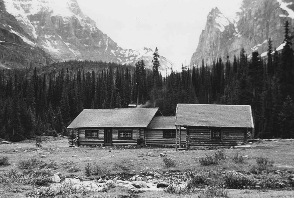
Club photographs
https://archives.whyte.org/en/permalink/descriptions7214
- Part Of
- Alpine Club of Canada fonds
- Scope & Content
- Includes photographs of ACC property at Mount Assiniboine (accompanied by 2 maps - AC 018P); clubhouse view; move of library to Vancouver Public Library; Board meeting; closing party at the old clubhouse (AC 421P / 09-37); office staff.
- Date Range
- 1953-1983
- Reference Code
- V14 / AC 018P / 1-7
- V14 / AC 041P / 1
- V14 / AC 345P / 1-3
- V14 / AC 363P / 1
- V14 / AC 421P / 09-37
- V14 / AC 421P / 52-53
- Description Level
- 5 / File
- GMD
- Photograph
- Photograph print
5 images
- Part Of
- Alpine Club of Canada fonds
- Description Level
- 5 / File
- Fonds Number
- M200 / S6 / V14
- Series
- I.A.2.i. Administration: photography and photographs
- Sous-Fonds
- V14
- Accession Number
- 5200
- Reference Code
- V14 / AC 018P / 1-7
- V14 / AC 041P / 1
- V14 / AC 345P / 1-3
- V14 / AC 363P / 1
- V14 / AC 421P / 09-37
- V14 / AC 421P / 52-53
- Date Range
- 1953-1983
- Physical Description
- ca.44 photographs : prints
- Scope & Content
- Includes photographs of ACC property at Mount Assiniboine (accompanied by 2 maps - AC 018P); clubhouse view; move of library to Vancouver Public Library; Board meeting; closing party at the old clubhouse (AC 421P / 09-37); office staff.
- Name Access
- Alpine Club of Canada
- Subject Access
- Abbot Pass Hut
- Activities
- Administration
- Advertising
- Alpine Club of Canada
- Alpine Club House
- Cabins
- Cabins and shelters
- Camps
- Club
- Competition
- Discovery and exploration
- Environment
- Environment and Nature
- Exploration
- Guide
- Guides
- Hiking
- Huts
- Mountain
- Mountain guides
- Mountaineering
- Mountaineers
- Mountains
- Mount Assiniboine
- National parks and reserves
- Organizations
- Photography
- Scenery
- Sports and recreation
- Summit
- Geographic Access
- Banff National Park
- Jasper National Park
- Yoho National Park
- Alberta
- British Columbia
- Canada
- Language
- English
- Title Source
- Title based on material
- Processing Status
- Processed
Images


This material is presented as originally created; it may contain outdated cultural descriptions and
potentially offensive content.
Read more.
Deep Powder and Steep Rock - visual
https://archives.whyte.org/en/permalink/descriptions55083
- Part Of
- Chic Scott fonds
- Scope & Content
- Photograph series consists of discs with reference scans of photographs pertaining to the research and creation of Deep Powder and Steep Rock.
- Date Range
- ca. 1950 - 2009
- Reference Code
- V40 / V
- Description Level
- 3 / Series
- GMD
- Photograph
- Part Of
- Chic Scott fonds
- Description Level
- 3 / Series
- Fonds Number
- M57 / V40 / S47
- Series
- V40 / V : Deep Powder and Steep Rock
- Sous-Fonds
- V40
- Accession Number
- 2015.8559
- Reference Code
- V40 / V
- GMD
- Photograph
- Date Range
- ca. 1950 - 2009
- Physical Description
- 53 discs with image files -- 6 cm of scanned photograph copies -- 62 reference slides : col. ; 35mm -- 27 reference photographs : col. prints
- History / Biographical
- Hans Gmoser played a major role in creating Canada’s vibrant mountain community. Although known internationally as the father of heli-skiing, he was much more than that: a talented rock climber, tireless expedition leader, a mountain guide, film maker and organizer. Deep Powder and Steep Rock presents an intimate portrait of this charismatic man. Much of the story is told in Gmoser’s own words, gleaned from his diaries, expedition journals, film commentaries and personal correspondence. It is a unique tale of adventure, hard work, perseverance and ultimate success.
- Scope & Content
- Photograph series consists of discs with reference scans of photographs pertaining to the research and creation of Deep Powder and Steep Rock.
- Name Access
- Scott, Chic
- Gmoser, Hans
- Subject Access
- Backcountry skiing
- Environment
- Landscapes
- Mountains
- Mountaineering
- Mountaineers
- Publication
- Recreation
- Research
- Skiing
- Ski mountaineering
- Sports
- Sports and recreation
- Winter sports
- Guiding
- Helicopter skiing
- Geographic Access
- Canada
- Alberta
- Banff National Park
- Canadian Rocky Mountains
- Access Restrictions
- for reference use only
- Reproduction Restrictions
- Reference only no reproductions
- Language
- English
- Related Material
- S47 / V
- M57 / V
- Category
- Sports, recreation and leisure
- Biographical Source Notes
- http://chicscott.com/books.htm
- Title Source
- Title based on contents of file
- Processing Status
- Processed / Unprocessed
This material is presented as originally created; it may contain outdated cultural descriptions and
potentially offensive content.
Read more.
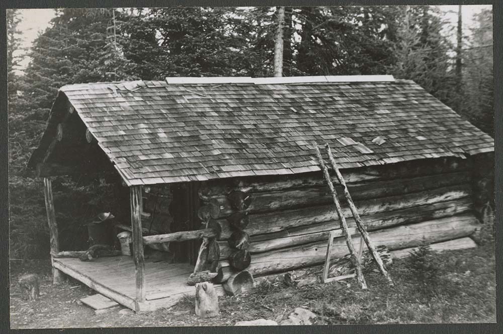
Existing huts, hut photos
https://archives.whyte.org/en/permalink/descriptions6577
- Part Of
- Alpine Club of Canada fonds
- Scope & Content
- File includes letters and photographs, slides, and negatives of huts.
- Date Range
- 1964-1979
- Reference Code
- M200 / AC 421 / 161
- V14 / AC 421P / 106 - 161
- Description Level
- 5 / File
- GMD
- Photograph
- Photograph print
1 image
- Part Of
- Alpine Club of Canada fonds
- Description Level
- 5 / File
- Fonds Number
- M200 / S6 / V14
- Series
- I.A.2.e. Administration: huts / properties
- Sous-Fonds
- V14
- Accession Number
- 5200
- Reference Code
- M200 / AC 421 / 161
- V14 / AC 421P / 106 - 161
- Date Range
- 1964-1979
- Physical Description
- 1 file of textual records. -- 55 photographs (47 prints, 6 negatives, 2 transparencies).
- Scope & Content
- File includes letters and photographs, slides, and negatives of huts.
- Name Access
- Alpine Club of Canada
- Subject Access
- Abbot Pass Hut
- Activities
- Administration
- Advertising
- Alpine Club of Canada
- Alpine Club House
- Cabins
- Cabins and shelters
- Camps
- Club
- Competition
- Discovery and exploration
- Environment
- Environment and Nature
- Exploration
- Guide
- Guides
- Hiking
- Huts
- Mountain
- Mountain guides
- Mountaineering
- Mountaineers
- Mountains
- National parks and reserves
- Organizations
- Photography
- Scenery
- Sports and recreation
- Summit
- Geographic Access
- Banff National Park
- Jasper National Park
- Yoho National Park
- Alberta
- British Columbia
- Canada
- Access Restrictions
- Access to negatives is by appointment only
- Language
- English
- Title Source
- Title based on contents of file
- Processing Status
- Processed
Images
This material is presented as originally created; it may contain outdated cultural descriptions and
potentially offensive content.
Read more.
Fernie Alpine Resort
https://archives.whyte.org/en/permalink/descriptions54883
- Part Of
- Murray Hay fonds
- Scope & Content
- File consists of 2 maps (1 base, 4 overlays) : col., annotations, on mylar ; 32 x 27 cm and 30 x 22 cm, and 2 prints : col. ; 35 x 28 cm. File pertains to Murray Hay's rendering of the ski hill at Fernie, British Columbia. File includes two reproduced drafts with mylar overlays (one held together b…
- Date Range
- ca.1977-ca.1997
- Reference Code
- V795 / II / A / vi / 1-2
- Description Level
- 5 / File
- GMD
- Map
- Private record
- Part Of
- Murray Hay fonds
- Description Level
- 5 / File
- Fonds Number
- M570 / V795
- Series
- V795 / II : Unpublished Material
- Sous-Fonds
- V795
- Sub-Series
- V795 / II / A : British Columbia / vi : Fernie
- Accession Number
- 2019.41
- Reference Code
- V795 / II / A / vi / 1-2
- GMD
- Map
- Private record
- Date Range
- ca.1977-ca.1997
- Physical Description
- 2 maps (1 base, 4 overlays) : col., annotations, on mylar ; 32 x 27 cm and 30 x 22 cm
- 2 prints : col. ; 35 x 28 cm
- Scope & Content
- File consists of 2 maps (1 base, 4 overlays) : col., annotations, on mylar ; 32 x 27 cm and 30 x 22 cm, and 2 prints : col. ; 35 x 28 cm. File pertains to Murray Hay's rendering of the ski hill at Fernie, British Columbia. File includes two reproduced drafts with mylar overlays (one held together by tape or glue, the other by masking tape), and two reproduced draft prints of the ski area.
- Notes
- Date range is approximate. The Timberland sub-division was developed between 1981-1991. The resort was known as Fernie Snow Valley until 1997.
- Name Access
- Hay, Murray
- Subject Access
- Advertising
- Art
- Artist
- Ski Maps
- Cartography
- Sports and recreation
- Tourism
- Tourist information
- Winter
- Winter sports
- Ski area
- Geographic Access
- Fernie
- British Columbia
- Canada
- Canadian Rocky Mountains
- Language
- English
- Conservation
- Masking tape should be removed and alternative preservation methods should be considered at a reasonable time to do so.
- Creator
- Hay, Murray
- Title Source
- Title based on contents of file
- Processing Status
- Processed
This material is presented as originally created; it may contain outdated cultural descriptions and
potentially offensive content.
Read more.
FINANCE - 1978 to 1986
https://archives.whyte.org/en/permalink/descriptions58208
- Part Of
- Alpine Club of Canada fonds
- Scope & Content
- File contains outlines of proposed requests from Fitness Canada, a draft report on the National Mountaineering Program Proposal, the 1984 grant profile, and the Fitness Canada Grant Requests report from 1982. Also includes a report on 1978 Federal and Alberta grants and 1980-1981 reports Re: Provin…
- Date Range
- 1979-1984
- Reference Code
- M200 / II / C / 5
- Description Level
- 5 / File
- GMD
- Textual record
- Organization record
- Part Of
- Alpine Club of Canada fonds
- Description Level
- 5 / File
- Fonds Number
- M200
- V14
- S6
- Series
- M200 / II: Financial Records
- Sous-Fonds
- M200
- Sub-Series
- M200 / II / C: Scholarships and Grants
- Accession Number
- accn. 2023.06
- Reference Code
- M200 / II / C / 5
- Date Range
- 1979-1984
- Physical Description
- 1 cm of textual records
- Scope & Content
- File contains outlines of proposed requests from Fitness Canada, a draft report on the National Mountaineering Program Proposal, the 1984 grant profile, and the Fitness Canada Grant Requests report from 1982. Also includes a report on 1978 Federal and Alberta grants and 1980-1981 reports Re: Provincial Recreation Association Financial Assistance.
- Notes
- Grant financials have been separated from their corresponding financial reports and statements; for these records see files M200 / II / A / 57 FINANCE - 1978 to 1986, M200 / II / A / 58 FINANCE - 1978 to 1986, and M200 / II / A / 59 FINANCE - 1978 to 1986 accn. 2023.06. These grant financials have been separated from their corresponding Club meeting minutes and reports; see M200 / I / A / 69 FINANCE - 1978 to 1986 accn. 2023.06.
- Name Access
- Alpine Club of Canada
- Subject Access
- Administration
- Alberta
- Alpine Club of Canada
- Club
- Grants
- Finances
- Mountain
- Mountaineers
- Mountaineering
- Mountains
- Record keeping
- Records
- Report
- Sports
- Sports and recreation
- Sports and leisure
- Organizations
- Geographic Access
- Canada
- Alberta
- Edmonton
- Edmonton, AB
- Banff
- Banff, AB
- Access Restrictions
- Restrictions may apply
- Reproduction Restrictions
- Contains personal information
- Language
- English
- Related Material
- M200 / II / A / 57
- M200 / II / A / 58
- M200 / II / A / 59
- M200 / I / A / 69
- Title Source
- Original title
- Processing Status
- Processed
This material is presented as originally created; it may contain outdated cultural descriptions and
potentially offensive content.
Read more.
Finance Committee - 1977-1978
https://archives.whyte.org/en/permalink/descriptions58205
- Part Of
- Alpine Club of Canada fonds
- Scope & Content
- File contains correspondence and reports Re: Federal Government Grants and Grant Applications between 1977 and 1978.
- Date Range
- 1977-1978
- Reference Code
- M200 / II / C / 2
- Description Level
- 5 / File
- GMD
- Textual record
- Organization record
- Part Of
- Alpine Club of Canada fonds
- Description Level
- 5 / File
- Fonds Number
- M200
- V14
- S6
- Series
- M200 / II: Financial Records
- Sous-Fonds
- M200
- Sub-Series
- M200 / II / C: Scholarships and Grants
- Accession Number
- accn 2023.06
- Reference Code
- M200 / II / C / 2
- Date Range
- 1977-1978
- Physical Description
- 0.5 cm of textual records
- Scope & Content
- File contains correspondence and reports Re: Federal Government Grants and Grant Applications between 1977 and 1978.
- Notes
- Financial grant records have been separated from their corresponding Financial Statements and Reports; for these Statements and Reports, see M200 / II / A / 50 Finance Committee - 1977-1978, and M200 / II / A / 51 Finance Committee - 1977-1978 accn. 2023.06.
- Name Access
- Alpine Club of Canada
- Subject Access
- Administration
- Alpine Club of Canada
- Club
- Finances
- Grants
- Mountain
- Mountaineering
- Mountaineers
- Mountains
- Record keeping
- Records
- Report
- Sports and leisure
- Sports and recreation
- Organizations
- Geographic Access
- Canada
- Ontario
- Alberta
- Waterloo, ON
- Banff
- Banff, AB
- Access Restrictions
- Restrictions may apply
- Reproduction Restrictions
- Contains personal information
- Language
- English
- Related Material
- M200 / II / A / 50
- M200 / II / A / 51
- Title Source
- Original title
- Processing Status
- Processed
This material is presented as originally created; it may contain outdated cultural descriptions and
potentially offensive content.
Read more.
- Part Of
- Alpine Club of Canada fonds
- Scope & Content
- File consists of a summit record from Haddo Peak produced by the Alpine Club of Canada between 1968 and 2001. Summit record includes entries from visitors to the various summits which pertain to individuals' hiking and climbing trips; details of specific events which occurred while at the summit, w…
- Date Range
- 1968-2001
- Reference Code
- M200 / V / A / 212
- Description Level
- 5 / File
- GMD
- Textual record
- Organization record
- Part Of
- Alpine Club of Canada fonds
- Description Level
- 5 / File
- Fonds Number
- M200
- V14
- S6
- Series
- M200 / V: Summit Records
- Sous-Fonds
- M200
- Sub-Series
- M200 / V / A: Identified Summit Records
- Accession Number
- accn. 2023.10
- Reference Code
- M200 / V / A / 212
- Responsibility
- Summit Registers and Notes produced by Alpine Club of Canada
- Date Range
- 1968-2001
- Physical Description
- 1 volume 1 cm of textual record
- History / Biographical
- Haddo Peak is located in the Lake Louise area of Banff National Park, Alberta. Haddo Peak is attached to Mount Aberdeen. Nearby is the Plain of the Six Glaciers Tea House, Lake Louise, Mount Victoria, Mount Lefroy and Mount Temple.
- Scope & Content
- File consists of a summit record from Haddo Peak produced by the Alpine Club of Canada between 1968 and 2001. Summit record includes entries from visitors to the various summits which pertain to individuals' hiking and climbing trips; details of specific events which occurred while at the summit, wildlife sightings, trail updates, and related topics. File: M200 / V / A / 212: Haddo [Peak]
- Name Access
- Alpine Club of Canada
- Subject Access
- Alberta
- Alpine Club of Canada
- Backpacking
- Banff
- Banff National Park
- Bow Valley
- Climbing
- Club
- Description and travel
- Environment
- Environment and Nature
- Hiking
- Lake Louise
- Mountain
- Mountaineering
- Mountaineers
- Mountains
- National parks and reserves
- Plain of Six Glacier Teahouse
- Record keeping
- Sports and leisure
- Sports and recreation
- Summit
- Temple Mountain
- Trails
- Geographic Access
- Canada
- Canadian Rocky Mountains
- Rocky Mountains
- Alberta
- Banff National Park
- Lake Louise
- Lake Louise, AB
- Plain of Six Glaciers
- Mount Victoria
- Mount Lefroy
- Mount Temple
- Mount Aberdeen
- Haddo Peak
- Access Restrictions
- Restrictions may apply
- Language
- English
- Related Material
- M235
- Title Source
- Title based on contents of file
- Processing Status
- Processed
This material is presented as originally created; it may contain outdated cultural descriptions and
potentially offensive content.
Read more.
- Part Of
- Alpine Club of Canada fonds
- Scope & Content
- Series consists of hut registers produced by the Alpine Club of Canada between ca.1930-2020. Registers include entries from visitors to the huts, which pertain to individuals' hiking and climbing trips; details of specific events which occurred while staying at the huts; wildlife sightings; custodi…
- Date Range
- [ca.1930-2020]
- Reference Code
- M200 / IV
- Description Level
- 3 / Series
- GMD
- Textual record
- Organization record
- Part Of
- Alpine Club of Canada fonds
- Description Level
- 3 / Series
- Fonds Number
- M200
- S6
- V14
- Series
- M200 / IV : Hut Registers
- Sous-Fonds
- M200
- Accession Number
- accn. 2023.19 accn. 8002 accn. 2023.20 accn. 2023.32 accn. 1299 accn. 1040 accn. 2141 accn. 3298 accn. 3757 accn. 6376 accn. 6465 accn. 6623 accn. 7779 accn. 2023.10 accn. 5538 accn. 2014.8293 accn. 2023.31 accn. 2023.15 accn. 2020.05 accn. 6766 accn. 2376 accn. 3296 accn. 3970 accn. 5215 accn. 3560 accn. 2014.8278 accn. 5462 accn. 3382 accn. 5330 accn. 6457 accn. 5635 accn. 5591 accn. 8120 accn. 2376 accn. 3560 accn. 2023.41 accn. 8119 accn. 2023.14 accn. 3160 accn. 3298 accn. 3970 accn. 5114 accn. 5200 accn. 5463 accn. 5631 accn. 6470
- Reference Code
- M200 / IV
- Responsibility
- Registers produced by Alpine Club of Canada
- Date Range
- [ca.1930-2020]
- Physical Description
- ca. 3.5 metres of textual records
- Scope & Content
- Series consists of hut registers produced by the Alpine Club of Canada between ca.1930-2020. Registers include entries from visitors to the huts, which pertain to individuals' hiking and climbing trips; details of specific events which occurred while staying at the huts; wildlife sightings; custodial issues and updates; and related topics. Series is separated at the sub-series level by individual huts: M200 / IV / A : Abbot Pass Hut M200 / IV / B : Elizabeth Parker Hut M200 / IV / C : Wates-Gibson Hut M200 / IV / D : A. O. Wheeler Hut M200 / IV / E : Sydney Vallance (Fryatt) Hut M200 / IV / F : Bow Hut M200 / IV / G : Stanley Mitchell Hut M200 / IV / H : Fay Hut M200 / IV / I : Balfour Hut M200 / IV / J : Peyto Hut/ Peter and Catharine Whyte Hut M200 / IV / K : Elk Lakes Cabin M200 / IV / L : Bon Echo Hut M200 / IV / M : Bill Putnam / Fairy Meadows Hut M200 / IV / N : Scott Duncan Hut M200 / IV / O: Conrad Kain/Bugaboos Hut M200 / IV / P: Neil Colgan Hut M200 / IV / Q: Silver Spray Hut M200 / IV / R: Asulkan Hut M200 / IV / S: Mount Colin Hut M200 / IV / T: Great Cairn Hut M200 / IV / U: Other Huts [Registers]
- Notes
- See sub-series entries for chronological inventories of hut registers
- Name Access
- Alpine Club of Canada
- Subject Access
- Abbot Pass Hut
- Backcountry skiing
- Buildings and facilities
- Cabins
- Cabins and shelters
- Climbing
- Environment
- Exploration
- Helicopter skiing
- Huts
- Log structures
- Memorial
- Mountaineering
- Mountains
- Parks Canada
- Peter Whyte Hut
- Porcupine
- Property
- Recreation
- Ski areas
- Sports
- Sports and recreation
- Wildlife
- Winter sports
- Geographic Access
- Canada
- Alberta
- British Columbia
- Canadian Rocky Mountains
- Access Restrictions
- Restrictions may apply
- Language
- English
- Related Material
- M235
- Title Source
- Title based on contents of series
- Processing Status
- Processed
This material is presented as originally created; it may contain outdated cultural descriptions and
potentially offensive content.
Read more.
Identified Summit Records
https://archives.whyte.org/en/permalink/descriptions57799
- Part Of
- Alpine Club of Canada fonds
- Scope & Content
- Sub-series of identified summit registers and notes produced by the Alpine Club of Canada between 1930 and 2022. Summit records include entries from visitors to the various summits which pertain to individuals' hiking and climbing trips; details of specific events which occurred while at the summit…
- Date Range
- 1930-1931
- 1959-1968
- 1970-1989
- 1992 -2022
- Reference Code
- M200 / V / A
- Description Level
- 4 / Sub-series
- GMD
- Textual record
- Organization record
- Part Of
- Alpine Club of Canada fonds
- Description Level
- 4 / Sub-series
- Fonds Number
- M200
- V14
- S6
- Series
- M200 / V: Summit Records
- Sous-Fonds
- M200
- Sub-Series
- M200 / V / A: Identified Summit Records
- Accession Number
- accn. 2023.20 accn. 7779 accn. 2023.10 accn. 2014.8347 accn. 6465 accn. 8002 accn. 2020.05 accn. 2023.19 accn. 2014.8293 accn. 8119 accn. 2023.32 accn. 2023.41 accn. 6623 accn. 6062 accn. 2014.8318 accn. 6767 accn. 2014.8315 accn. 2014.8317 accn. 5680 accn. 2023.16 accn. 2018.9010 accn. 5396 accn. 6459 accn. 2014.8316 accn. 2023.18 accn. 5631 accn. 2013.8245 accn. 2014.8275 accn. 2023.06 accn. 2023.14 accn. 2023.17 accn. 5569 accn. 8113 accn. 6396 accn. 2024.20
- Reference Code
- M200 / V / A
- Responsibility
- Summit Registers and Notes produced by Alpine Club of Canada
- Date Range
- 1930-1931
- 1959-1968
- 1970-1989
- 1992 -2022
- Physical Description
- 100 cm of textual records 223 volumes
- Scope & Content
- Sub-series of identified summit registers and notes produced by the Alpine Club of Canada between 1930 and 2022. Summit records include entries from visitors to the various summits which pertain to individuals' hiking and climbing trips; details of specific events which occurred while at the summit, wildlife sightings, trail updates, and related topics. The sub-series is separated into individual identified summit records.
- Notes
- See file-level entries for inventories of identified summit registers and notes.
- Name Access
- Alpine Club of Canada
- Subject Access
- Alberta
- Alpine Club of Canada
- Backpacking
- Backcountry skiing
- Banff
- Banff National Park
- Bow Valley
- British Columbia
- Castle Mountain
- Cascade Mountain
- Centennial
- Climbing
- Club
- Cross-country skiing
- Description and travel
- Environment
- Environment and Nature
- Fortress Mountain
- Great Divide
- Hiking
- Kananaskis Country
- Mount Assiniboine
- Mount Logan
- Mountain
- Mountain guides
- Mountaineering
- Mountaineers
- Mountains
- Provincial parks and reserves
- Parks
- National parks and reserves
- Record keeping
- Ski area
- Ski areas
- Ski mountaineering
- Skiing
- Skis
- Skiers
- Snowshoes and snowshoeing
- Sports and leisure
- Sports and recreation
- Summit
- Trails
- Winter sports
- Geographic Access
- Canada
- Canadian Rocky Mountains
- Rocky Mountains
- Continental Divide
- Great Divide
- Alberta
- British Columbia
- Abbot Pass
- Mount Assiniboine
- Cascade Mountain
- Canmore
- Assiniboine
- Banff National Park
- Banff, Alberta
- Bugaboos
- Castle Mountain, AB
- Cathedral Mountain
- Glacier
- Jasper National Park
- Kananaskis Country
- Little Yoho Valley
- Mount Baldy
- Mount Baker
- Mount Cory
- Mount Edith
- Mount Lefroy
- Mount Norquay
- Mount Rundle
- Rundle Mountain
- Mount Temple
- Mount Victoria
- Mount Yamnuska
- Selkirks
- Yoho National Park
- Access Restrictions
- Restrictions may apply
- Reproduction Restrictions
- Contains personal information
- Language
- English
- Conservation
- Some records have been placed in mylar. Some record have mold, rust or water damage.
- Related Material
- M235
- Title Source
- Title based on contents of sub-series
- Processing Status
- Processed
This material is presented as originally created; it may contain outdated cultural descriptions and
potentially offensive content.
Read more.
Individual, family, & group portraits
https://archives.whyte.org/en/permalink/descriptions56505
- Part Of
- Ron Duke fonds
- Scope & Content
- Sub-series pertains to 367 b&w and colour prints depicting group and individual portraits. Includes school yearbook headshots, high school prom/grad group photos, community organization award ceremonies, passport photos, posed studio portraits, weddings, and baby photos.
- Date Range
- [ca. 1965-1975]
- Reference Code
- V180 / V / B / iii / PA - 01 to PA - 367 o.s.
- Description Level
- 4 / Sub-series
- GMD
- Photograph
- Photograph print
- Part Of
- Ron Duke fonds
- Description Level
- 4 / Sub-series
- Fonds Number
- M175 / V180
- Series
- V.B. Later material / prints
- Sous-Fonds
- V180
- Accession Number
- .
- Reference Code
- V180 / V / B / iii / PA - 01 to PA - 367 o.s.
- Date Range
- [ca. 1965-1975]
- Physical Description
- 367 photographs : b&w and col. ; 25.1 x 20.1 cm or smaller
- History / Biographical
- See fonds level description
- Scope & Content
- Sub-series pertains to 367 b&w and colour prints depicting group and individual portraits. Includes school yearbook headshots, high school prom/grad group photos, community organization award ceremonies, passport photos, posed studio portraits, weddings, and baby photos.
- Notes
- PA - 364 o.s. to PA - 367 o.s. in oversize
- Name Access
- Walking Buffalo (George McLean)
- McLean, George
- Subject Access
- Banff Elementary School
- Banff High School
- Children
- Community events
- Family and personal life
- Photography
- Portrait
- Sports and leisure
- Sports and recreation
- Weddings
- Geographic Access
- Banff
- Banff National Park
- Language
- NA
- Creator
- Duke, Ron
- Title Source
- Title based on contents of sub-series
- Processing Status
- Processed
This material is presented as originally created; it may contain outdated cultural descriptions and
potentially offensive content.
Read more.
- Part Of
- Murray Hay fonds
- Scope & Content
- File consists of 8 colour prints, 28 x 35 cm or smaller. File pertains to Murray Hay's work for the City of Kimberley, British Columbia. File includes prints of original paintings done by Hay relating to a proposed real estate development in the city and the Kimberley ski hill.
- Date Range
- ca.1979-ca.2000
- Reference Code
- V795 / II / A / iii / 1-2
- Description Level
- 5 / File
- GMD
- Map
- Private record
- Part Of
- Murray Hay fonds
- Description Level
- 5 / File
- Fonds Number
- M570 / V795
- Series
- V795 / II : Unpublished Material
- Sous-Fonds
- V795
- Sub-Series
- V795 / II / A : British Columbia / iii : Kimberley
- Accession Number
- 2019.41
- Reference Code
- V795 / II / A / iii / 1-2
- GMD
- Map
- Private record
- Date Range
- ca.1979-ca.2000
- Physical Description
- 8 prints : col. ; 28 x 35 cm or smaller
- Scope & Content
- File consists of 8 colour prints, 28 x 35 cm or smaller. File pertains to Murray Hay's work for the City of Kimberley, British Columbia. File includes prints of original paintings done by Hay relating to a proposed real estate development in the city and the Kimberley ski hill.
- Notes
- The ski hill at Kimberley was developed in 1979.
- Most of the prints are annotated in ink by Hay (his own notes and comments by clients).
- Name Access
- Hay, Murray
- Subject Access
- Advertising
- Artist
- Art
- Cartography
- Community life
- Landscapes
- Map
- Mountains
- Municipal views
- Ski area
- Ski Maps
- Sports and recreation
- Tourism
- Tourist information
- Winter
- Kimberley Alpine Resort
- Geographic Access
- Kimberley
- British Columbia
- Canada
- Purcell Mountains
- Language
- English
- Conservation
- There is masking tape holding some of the prints together on a piece of paper, which should be removed and alternative preservation methods should be considered at a reasonable time to do so.
- Creator
- Hay, Murray
- Title Source
- Title based on contents of file
- Processing Status
- Processed
This material is presented as originally created; it may contain outdated cultural descriptions and
potentially offensive content.
Read more.
Lake Louise Area
https://archives.whyte.org/en/permalink/descriptions54925
- Part Of
- Murray Hay fonds
- Scope & Content
- File consists of 6 prints : col. ; 25.5 x 20 cm or smaller. File pertains to Murray Hay's renderings of the Lake Louise ski area. File includes six reproduced draft prints of original paintings of the Lake Louise ski area created by Murray Hay (different iterations).
- Date Range
- ca.1976-ca.2000
- Reference Code
- V795 / II / B / ii / 1
- Description Level
- 5 / File
- GMD
- Map
- Private record
- Part Of
- Murray Hay fonds
- Description Level
- 5 / File
- Fonds Number
- M570 / V795
- Series
- V795 / I : Unpublished Material
- Sous-Fonds
- V795
- Sub-Series
- V795 / I / B : Alberta / ii : Lake Louise
- Accession Number
- 2019.41
- Reference Code
- V795 / II / B / ii / 1
- GMD
- Map
- Private record
- Date Range
- ca.1976-ca.2000
- Physical Description
- 6 prints : col. ; 25.5 x 20 cm or smaller
- Scope & Content
- File consists of 6 prints : col. ; 25.5 x 20 cm or smaller. File pertains to Murray Hay's renderings of the Lake Louise ski area. File includes six reproduced draft prints of original paintings of the Lake Louise ski area created by Murray Hay (different iterations).
- Name Access
- Hay, Murray
- Subject Access
- Advertising
- Artist
- Ski Maps
- Map
- Cartography
- Sports and recreation
- Tourism
- Tourist information
- Winter
- Winter sports
- Ski area
- Lake Louise Ski Area
- Geographic Access
- Lake Louise
- Alberta
- Canada
- Canadian Rocky Mountains
- Language
- English
- Related Material
- M570 / III / B / ii / 1-2
- Creator
- Hay, Murray
- Title Source
- Title based on contents of file
- Processing Status
- Processed
This material is presented as originally created; it may contain outdated cultural descriptions and
potentially offensive content.
Read more.
Lake O'Hara Trails
https://archives.whyte.org/en/permalink/descriptions54776
- Part Of
- Murray Hay fonds
- Scope & Content
- File consists of 0.5 cm of textual records, 60.5 x 48.5 cm. File pertains to a trail map of the Lake O'Hara area created by Murray Hay. File consists of one published poster depicting a reproduced map of the trails at Lake O'Hara in Yoho National Park (British Columbia).
- Date Range
- ca.1970-ca.2015
- Reference Code
- M570 / III / A / iv / 1
- Description Level
- 5 / File
- GMD
- Map
- Poster
- Published record
- Textual record
- Part Of
- Murray Hay fonds
- Description Level
- 5 / File
- Fonds Number
- M570 / V795
- Series
- M570 / III : Murray Hay Portfolio (published material)
- Sous-Fonds
- M570
- Sub-Series
- M570 / III / A : British Columbia / iv : Lake O'Hara
- Accession Number
- 2019.41
- Reference Code
- M570 / III / A / iv / 1
- Date Range
- ca.1970-ca.2015
- Physical Description
- 0.5 cm of textual material (60.5 x 48.5 cm)
- Scope & Content
- File consists of 0.5 cm of textual records, 60.5 x 48.5 cm. File pertains to a trail map of the Lake O'Hara area created by Murray Hay. File consists of one published poster depicting a reproduced map of the trails at Lake O'Hara in Yoho National Park (British Columbia).
- Notes
- M570 / III / A / iv / 1 is oversize.
- Name Access
- Hay, Murray
- Subject Access
- Trails
- Hiking
- Cartography
- Advertising
- Artist
- Sports and recreation
- Travel
- Tourism
- Tourist information
- Geographic Access
- Lake O'Hara
- British Columbia
- Canada
- Canadian Rocky Mountains
- Yoho National Park
- Language
- English
- Title Source
- Title based on contents of file
- Processing Status
- Processed
This material is presented as originally created; it may contain outdated cultural descriptions and
potentially offensive content.
Read more.
- Part Of
- Murray Hay fonds
- Scope & Content
- File consists of 2 prints : col. ; 35 x 28 cm. File pertains to Murray Hay's rendering of Marmot Basin ski area in Jasper National Park. File includes two iterations of reproduction draft prints of Hay's map of Marmot Basin.
- Date Range
- ca.1976-ca.2000
- Reference Code
- V795 / II / B / i / 1
- Description Level
- 5 / File
- GMD
- Map
- Private record
- Part Of
- Murray Hay fonds
- Description Level
- 5 / File
- Fonds Number
- M570 / V795
- Series
- V795 / II : Unpublished Material
- Sous-Fonds
- V795
- Sub-Series
- V795 / II / B : Alberta / i : Jasper National Park
- Accession Number
- 2019.41
- Reference Code
- V795 / II / B / i / 1
- GMD
- Map
- Private record
- Date Range
- ca.1976-ca.2000
- Physical Description
- 2 prints : col. ; 35 x 28 cm
- Scope & Content
- File consists of 2 prints : col. ; 35 x 28 cm. File pertains to Murray Hay's rendering of Marmot Basin ski area in Jasper National Park. File includes two iterations of reproduction draft prints of Hay's map of Marmot Basin.
- Name Access
- Hay, Murray
- Subject Access
- Advertising
- Artist
- Ski Maps
- Ski area
- Map
- Cartography
- Sports and recreation
- Tourism
- Tourist information
- Winter
- Winter sports
- Geographic Access
- Jasper Marmot Basin
- Jasper National Park
- Alberta
- Canada
- Canadian Rocky Mountains
- Language
- English
- Related Material
- M570 / III / B / iii / 1
- Creator
- Hay, Murray
- Title Source
- Title based on contents of file
- Processing Status
- Processed
This material is presented as originally created; it may contain outdated cultural descriptions and
potentially offensive content.
Read more.
Misc. Photographs
https://archives.whyte.org/en/permalink/descriptions22922
- Part Of
- Hans Gmoser fonds
- Scope & Content
- File pertains to a collection of various topics, mostly skiing and climbing, from predominantly the 1970s and 1980s.
- Date Range
- 1965-1987
- Reference Code
- V68 / V / PA 20 - 960 to 1000
- Description Level
- 5 / File
- GMD
- Photograph
2 images
- Part Of
- Hans Gmoser fonds
- Description Level
- 5 / File
- Fonds Number
- M224 / S49 / V68
- Series
- V. Photograph Prints
- Sous-Fonds
- V68
- Accession Number
- 8111, 7877, 7361
- Reference Code
- V68 / V / PA 20 - 960 to 1000
- GMD
- Photograph
- Date Range
- 1965-1987
- Physical Description
- 40 photographs: prints, b&w; col.
- History / Biographical
- See fonds level description
- Scope & Content
- File pertains to a collection of various topics, mostly skiing and climbing, from predominantly the 1970s and 1980s.
- Notes
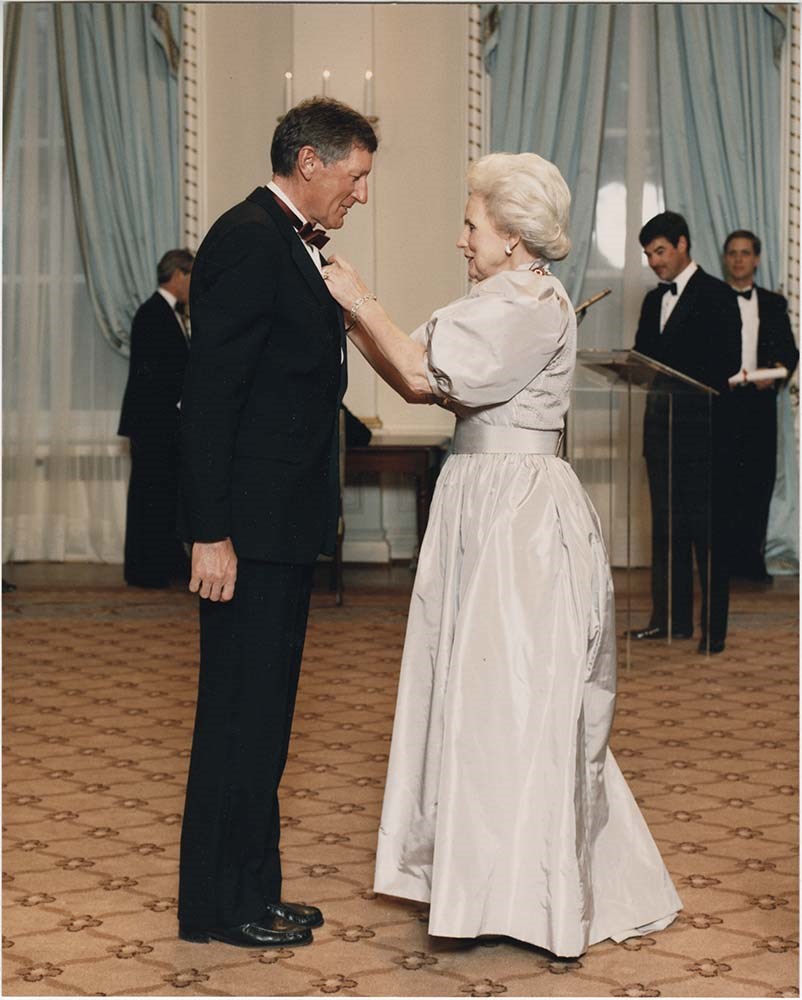
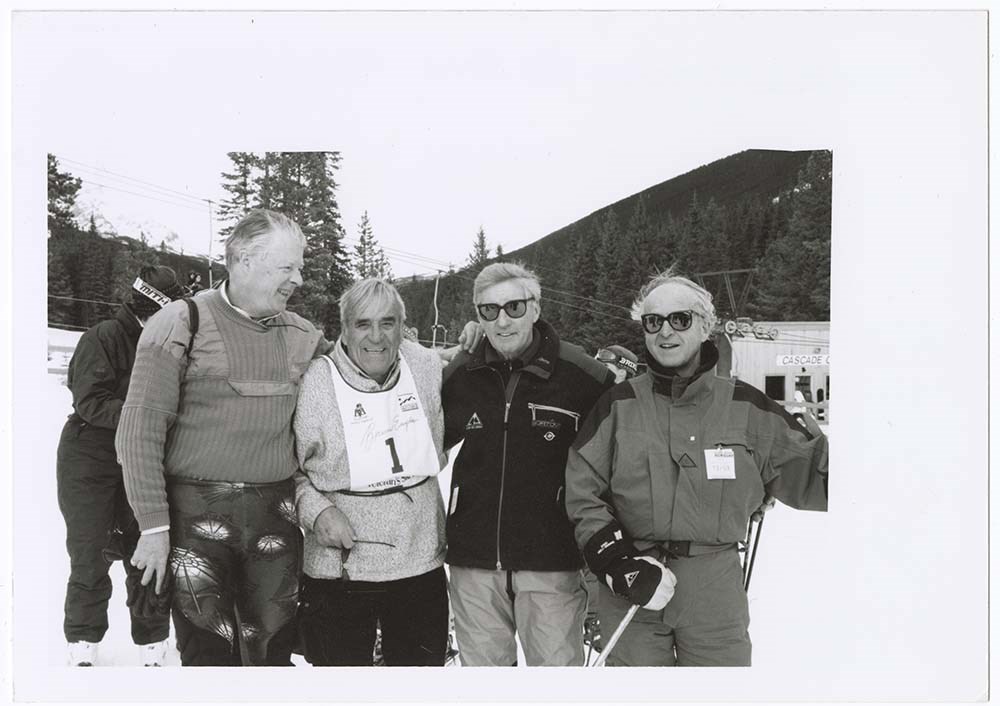
- V68/PA 965-971 enclosed with letter from Crown Princess of Norway Jan 20, 1989 from VIPs folder, V68/PA 972-977 from 7877, V68/PA 988-998 are photographs from Condolence correspondence, V68/PA 1000 from 7361. 960. [Gmoser receiving Order of Canada], 20 x 25.5 cm, colour, “GGC 87-420” written on back. 961. “Cariboo Mts Taken from Carr’s Lodge Looking SW”, March 3, 1971, 13 x 9 cm, colour, caption written on back, enclosed with letter discussing property for sale. 962. “Carr’s Lodge Taken from Fraser River Bank- looking NE”, March 3, 1971, 13 x 9 cm, colour, caption written on back, enclosed with letter discussing property for sale. 963. “Cariboo Mts and Fraser River from Carr’s Lodge looking south”, March 3, 1971, 13 x 9 cm, colour, caption written on back, enclosed with letter discussing property for sale. 964. [Gmoser in two shots], 6.5 x 14 cm, black and white, from 8111 Box 3/7 from Kodac Box. 965. [Man under Gothics Sign], 10 x 15 cm, colour, rounded corners. 966. [Woman in blue ski gear], 10 x 15 cm, colour, rounded corners. 967. [Three people], 10 x 15 cm, colour, rounded corners. 968. [Man and young boy], 10 x 15 cm, colour, rounded corners. 969. [Woman and young boy], 10 x 15 cm, colour, rounded corners. 970. [Woman and young boy], 10 x 15 cm, colour, rounded corners. 971. {Group of four], 13 x 18 cm, colour. From 7877 box 1/1. 972. “Lake O’Hara Lillian Gest, Conrad Gmoser, Robson Gmoser 1974?”, 9 x 13 cm, colour, caption written on post it note. 973. “Lizzie Rummel”, [Looking over valley], 13 x 9 cm, black and white, caption written on post it note. 974. “Ken Jones Summer 86 Assinboine”, 15 x 10 cm, colour, caption written on back. 975. “Ken Jones Summer 86 Assinboine”, 15 x 10 cm, colour, caption written on back. 976. “Veteran Ski Race March 99”, 18 x 13 cm, black and white, matt finish, “L-R Pat Duffy, Bruno Engler, Hans Gmoser, Leo Grillmair” written on post it note, caption written at front bottom. 977. Bruno Veteran Ski Race March 1999 [L-R Pat Duffy, Bruno Engler, Hans Gmoser, Leo Grillmair] 18 x 13 cm, black and white, matt finish. 978. “Bow Lake”, 10 x 7 cm, black and white, matt finish, inscription at bottom, from “Selected Real Photographs Canadian Pacific Rockies Photographed by Byron Harmon Photos.” 979. “Lake Louise”, [winter], 10 x 7 cm, black and white, matt finish, inscription at bottom, from “Selected Real Photographs Canadian Pacific Rockies Photographed by Byron Harmon Photos.” 980. “Lake Louise”, [summer], 10 x 7 cm, black and white, matt finish, inscription at bottom, from “Selected Real Photographs Canadian Pacific Rockies Photographed by Byron Harmon Photos.” 981. “Chateau Lake Louise”, 10 x 7 cm, black and white, matt finish, inscription at bottom, from “Selected Real Photographs Canadian Pacific Rockies Photographed by Byron Harmon Photos.” 982. “Consolation Lake”, 10 x 7 cm, black and white, matt finish, inscription at bottom, from “Selected Real Photographs Canadian Pacific Rockies Photographed by Byron Harmon Photos.” 983. “Mt. Temple”, 10 x 7 cm, black and white, matt finish, inscription at bottom, from “Selected Real Photographs Canadian Pacific Rockies Photographed by Byron Harmon Photos.” 984. “Moraine Lake”, 10 x 7 cm, black and white, matt finish, inscription at bottom, from “Selected Real Photographs Canadian Pacific Rockies Photographed by Byron Harmon Photos.” 985. “Lakes in the Clouds”, 10 x 7 cm, black and white, matt finish, inscription at bottom, from “Selected Real Photographs Canadian Pacific Rockies Photographed by Byron Harmon Photos.” 986. “Mt. Lefroy”, 10 x 7 cm, black and white, matt finish, inscription at bottom, from “Selected Real Photographs Canadian Pacific Rockies Photographed by Byron Harmon Photos.” 987. “Lake Agnes”, 10 x 7 cm, black and white, matt finish, inscription at bottom, from “Selected Real Photographs Canadian Pacific Rockies Photographed by Byron Harmon Photos.” 988. [Gmoser at Planica under biggest ski jump in the world], 10 x 15 cm, colour, from Dustan Polajnar. 989. [Rada Polajnar and Hans in Vrata valley, near waterfall Pericnik], 10 x 15 cm, colour, from Dustan Polajnar. 990. [Hans and Rada Polajnar in Vrata valley, under the Triglav north wall], 10 x 15 cm, colour, from Dustan Polajnar. 991. [Group of people listening to zither], 13 x 9 cm, colour. 992. [Hans playing zither], 13 x 9 cm, colour. 993. [Man playing zither], 13 x 9 cm, colour. 994. “Duers by Hans Gmoser Leo Grillmair Oct/52”, 9 x 13 cm, colour, caption written on back. 995. “The summit of Mt. Eisenhaus (Cath) Sept 52”, 15 x 10 cm, colour. 996. “Keir McGoogan en route to the summit Sept. 1952”, 15 x 10 cm, colour. 997. “Approaching Mt. Eisenhower Sept/52”, 15 x 10 cm, colour. 998. [Gmoser holding camera], 12 x 19 cm, Photograph by Erwin Tontsch, 1965, colour. 999. [Four people seated at table with red tablecloth, Hans Gmoser second from right], front bottom inscription “Peter Wingle 3/84”, 25 x 19 cm, colour, matt finish. 1000. “Jumbo to Bugaboo Jim McConkey, Glen, Hans Gmoser,” [Three people adjusting], photograph by E. Tontsch, 1965, 15 x 10 cm, colour, caption written on post it note. 1021. "Dhalagiri I, 26, 795, frmo the south west. Proposed line of ascent", [Image of peak with proposed ascent marked], 25.5 x 20 cm, black and white. 1022. [Photograph of Pierre Trudeau and Gmoser handshake], 25.5 x 20 cm, black and white. 1023. [From Mark Taggart letter and typed comments from up in Gothics March 24, 1987 and attached photograph of Gothics opening week], 15 x 10 cm, colour. 1024. "Everest, [?] Jean Troillet 8.4.86", 17.8 x 12.7 cm, colour.
- Name Access
- Gmoser, Hans
- Rummel, Elizabeth
- Rummel, Lizzie
- Engler, Bruno
- Subject Access
- Activities
- Awards
- Discovery and exploration
- Climbing
- Backcountry skiing
- Buildings
- Environment and Nature
- Exploration
- Family and personal life
- Mountains
- Mountaineering
- Order of Canada
- Portrait
- Photography
- Professional and Personal Life
- Scenery
- Sports and recreation
- Skiing
- Ski areas
- Geographic Access
- Alberta
- British Columbia
- Canada
- Language
- English
- Title Source
- Title based on contents of file
- Processing Status
- Processed
Images
This material is presented as originally created; it may contain outdated cultural descriptions and
potentially offensive content.
Read more.
- Part Of
- Murray Hay fonds
- Scope & Content
- File consists of 5 prints : b&w and col. ; 38 x 26.5 cm or smaller. FIle pertains to Murray Hay's work on different maps for a variety of places in British Columbia, Canada. File includes three draft prints of different iterations of the ski trails at the Fairmont Hot Springs resort; a map labelled…
- Date Range
- ca.1976-ca.2000
- Reference Code
- V795 / II / A / viii / 1-3
- Description Level
- 5 / File
- GMD
- Private record
- Map
- Part Of
- Murray Hay fonds
- Description Level
- 5 / File
- Fonds Number
- M570 / V795
- Series
- V795 / II : Unpublished Material
- Sous-Fonds
- V795
- Sub-Series
- V795 / II / A : British Columbia / viii : Miscellaneous
- Accession Number
- 2019.41
- Reference Code
- V795 / II / A / viii / 1-3
- GMD
- Private record
- Map
- Date Range
- ca.1976-ca.2000
- Physical Description
- 5 prints : b&w and col. ; 38 x 26.5 cm or smaller
- Scope & Content
- File consists of 5 prints : b&w and col. ; 38 x 26.5 cm or smaller. FIle pertains to Murray Hay's work on different maps for a variety of places in British Columbia, Canada. File includes three draft prints of different iterations of the ski trails at the Fairmont Hot Springs resort; a map labelled in pencil (on the back of the print) "Cypress Bowl Cross Country Ski Map - Vancouver", and a map glued or otherwise attached to a piece of white board labelled in blue ink "Blue River Heli Ski Area (approximately the size of Belgium."
- Name Access
- Hay, Murray
- Subject Access
- Advertising
- Artist
- Ski area
- Ski Maps
- Map
- Cartography
- Sports and recreation
- Tourism
- Tourist information
- Helicopter skiing
- Winter
- Winter sports
- Geographic Access
- Vancouver
- Fairmont Hot Springs
- Blue River Resort
- British Columbia
- Canada
- Language
- English
- Conservation
- Adhesives should be removed and alternative preservation methods should be used.
- Related Material
- M570 / III / A / vi / 1
- Creator
- Hay, Murray
- Title Source
- Title based on contents of file
- Processing Status
- Processed
This material is presented as originally created; it may contain outdated cultural descriptions and
potentially offensive content.
Read more.
- Part Of
- Alpine Club of Canada fonds
- Scope & Content
- File consists of summit records from Monarch Mountain produced by the Alpine Club of Canada between 1940 and 1979. Summit records include entries from visitors to the various summits which pertain to individuals' hiking and climbing trips; details of specific events which occurred while at the summ…
- Date Range
- 1940
- 1943
- 1960
- 1962-1979
- Reference Code
- M200 / V / A / 153
- Description Level
- 5 / File
- GMD
- Textual record
- Organization record
- Part Of
- Alpine Club of Canada fonds
- Description Level
- 5 / File
- Fonds Number
- M200
- V14
- S6
- Series
- M200 / V: Summit Records
- Sous-Fonds
- M200
- Sub-Series
- M200 / V / A: Identified Summit Records
- Accession Number
- accn. 2023.18
- Reference Code
- M200 / V / A / 153
- Responsibility
- Summit Registers and Notes produced by Alpine Club of Canada
- Date Range
- 1940
- 1943
- 1960
- 1962-1979
- Physical Description
- 1 cm of textual records 4 volumes
- History / Biographical
- Monarch Mountain is located in the Victoria Cross Ranges of Jasper National Park, Alberta. Nearby are Pyramid Mountain and Jasper town-site.
- Scope & Content
- File consists of summit records from Monarch Mountain produced by the Alpine Club of Canada between 1940 and 1979. Summit records include entries from visitors to the various summits which pertain to individuals' hiking and climbing trips; details of specific events which occurred while at the summit, wildlife sightings, trail updates, and related topics. File include: M200 / V / A / 153: Monarch Mtn
- Notes
- Materials came together in a plastic bag with a note "Monarch Mtn". Summit Register is believed to be from White Pyramid; materials have been kept together due to orginial order they were received from the Alpine Club of Canada.
- Name Access
- Alpine Club of Canada
- Subject Access
- Alberta
- Alpine Club of Canada
- Backpacking
- Backcountry skiing
- Climbing
- Club
- Description and travel
- Environment
- Environment and Nature
- Hiking
- Mountain
- Mountaineering
- Mountaineers
- Mountains
- National parks and reserves
- Record keeping
- Sports and leisure
- Sports and recreation
- Summit
- Geographic Access
- Canada
- Canadian Rocky Mountains
- Rocky Mountains
- Alberta
- Jasper National Park
- Jasper
- Jasper, AB
- Victoria Cross Range
- Monarch Mountain
- Access Restrictions
- Restrictions may apply
- Language
- English
- Conservation
- Summit notes placed in mylar due to mold and fragility. Summit register contains mold and water damage.
- Related Material
- M235
- M200 / V / A / 130
- Biographical Source Notes
- Peak Finder: Monarch Mountain, Canadian Rockies Database: https://cdnrockiesdatabases.ca/peaks/922
- Title Source
- Original title
- Processing Status
- Processed
This material is presented as originally created; it may contain outdated cultural descriptions and
potentially offensive content.
Read more.
Mount Colin Hut Registers
https://archives.whyte.org/en/permalink/descriptions57656
- Part Of
- Alpine Club of Canada fonds
- Scope & Content
- Sub-series of hut registers from the Mount Colin Centennial Hut produced by the Alpine Club of Canada between 1967 and 1993. Registers include entries from visitors to the huts which pertain to individuals' hiking and climbing trips; details of specific events which occurred while staying at the hu…
- Date Range
- 1967-1993
- Reference Code
- M200 / IV / S
- Description Level
- 4 / Sub-series
- GMD
- Textual record
- Organization record
- Part Of
- Alpine Club of Canada fonds
- Description Level
- 4 / Sub-series
- Fonds Number
- M200
- V14
- S6
- Series
- M200 / IV: Hut Registers
- Sous-Fonds
- M200
- Sub-Series
- M200 / IV / S: Mount Colin Hut Registers
- Accession Number
- accn. 2023.10
- Reference Code
- M200 / IV / S
- Responsibility
- Registers produced by Alpine Club of Canada
- Date Range
- 1967-1993
- Physical Description
- 6 volumes 7 cm of textual records
- History / Biographical
- According to the Alpine Club of Canada's website, the Mount Colin Centennial Hut is located in Jasper National Park at the base of the Southwest Face of Mount Colin. Located close by are Mounts Colin and CR6. The ACC states: "With a thorough renovation in the summer of 1999, the Colin Hut is a clean and efficient shelter which sleeps 6 comfortably in summer. Equipped with Coleman stoves and lanterns as well as a well stocked cooking area, this hut is similar in design to the Castle Mountain Hut."
- Scope & Content
- Sub-series of hut registers from the Mount Colin Centennial Hut produced by the Alpine Club of Canada between 1967 and 1993. Registers include entries from visitors to the huts which pertain to individuals' hiking and climbing trips; details of specific events which occurred while staying at the hut, wildlife sightings, custodial issues and updates, and related topics. The sub-series is separated into individual hut registers, arranged by date:
- M200 / IV / S / 1: Mount Colin hut register July 5, 1967 - Sept. 24, 1971
- M200 / IV / S / 2: Mount Colin hut register June 5, 1972 - July 19, 1975
- M200 / IV / S / 3: [Mount Colin hut register] Sept. 14, 1975 - Sept. 23, 1976
- M200 / IV / S / 4: [1975-1976 hut register]
- M200 / IV / S / 5: Mount Colin hut register July 30, 1983 - July 19, 1992
- M200 / IV / S / 6: Mount Colin hut register June 30, 1977 - Aug. 28, 1983; Aug 6, 1990 - Oct. 29, 1993
- Name Access
- Alpine Club of Canada
- Subject Access
- Huts
- Cabins
- Cabins and shelters
- Alberta
- Backpacking
- Buildings and facilities
- Climbing
- Environment and Nature
- Hiking
- Mountaineering
- Mountaineers
- Mountains
- National parks and reserves
- Ski mountaineering
- Skiing
- Sports and recreation
- Winter sports
- Geographic Access
- Canada
- Alberta
- Jasper National Park
- Jasper
- Access Restrictions
- Restrictions may apply
- Language
- English
- French
- Japanese
- Conservation
- Some registers have loose/broken bindings and loose pages.
- Biographical Source Notes
- Alpine Club of Canada website: https://www.alpineclubofcanada.ca/mount-colin-centennial-hut/
- Title Source
- Title based on contents of sub-series
- Processing Status
- Processed
This material is presented as originally created; it may contain outdated cultural descriptions and
potentially offensive content.
Read more.
Mount Lougheed Summit Registers
https://archives.whyte.org/en/permalink/descriptions57732
- Part Of
- Alpine Club of Canada fonds
- Scope & Content
- Files consist of summit notes and summit registers from Mount Lougheed produced by the Alpine Club of Canada between 1967 and 2017. Summit records include entries from visitors to the various summits which pertain to individuals' hiking and climbing trips; details of specific events which occurred …
- Date Range
- 1967-1970
- 1980
- 1996-2017
- Reference Code
- M200 / V / A / 140 to 142
- Description Level
- 5 / File
- GMD
- Textual record
- Organization record
- Part Of
- Alpine Club of Canada fonds
- Description Level
- 5 / File
- Fonds Number
- M200
- V14
- S6
- Series
- M200 / V: Summit Records
- Sous-Fonds
- M200
- Sub-Series
- M200 / V / A: Identified Summit Records
- Accession Number
- accn. 2023.19
- accn. 8119
- accn. 2023.41
- Reference Code
- M200 / V / A / 140 to 142
- Responsibility
- Summit Registers and Notes produced by Alpine Club of Canada
- Date Range
- 1967-1970
- 1980
- 1996-2017
- Physical Description
- 4 cm of textual records 3 volumes
- History / Biographical
- Mount Lougheed is located in Kananaskis Country near the Spray Lakes Reservoir, in Alberta. Mount Lougheed has three summits, and the mountain is part of the Canadian Rockies. The highest of the three peaks is known as Peak 2 or Lougheed II.
- Scope & Content
- Files consist of summit notes and summit registers from Mount Lougheed produced by the Alpine Club of Canada between 1967 and 2017. Summit records include entries from visitors to the various summits which pertain to individuals' hiking and climbing trips; details of specific events which occurred while at the summit, wildlife sightings, trail updates, and related topics. Files include: M200 / V / A / 140: [Mt. Lougheed, 1967-1970, 1980] M200 / V / A / 141: Mt. Lougheed 1996-2007 M200 / V / A / 142: [Lougheed II 2007-2017]
- Name Access
- Alpine Club of Canada
- Subject Access
- Alberta
- Alpine Club of Canada
- Backpacking
- Backcountry skiing
- Climbing
- Club
- Cross-country skiing
- Description and travel
- Environment
- Environment and Nature
- Hiking
- Kananaskis Country
- Mountain
- Mountaineering
- Mountaineers
- Mountains
- Record keeping
- Ski mountaineering
- Ski area
- Ski areas
- Skiing
- Skiers
- Skis
- Sports and leisure
- Sports and recreation
- Summit
- Trails
- Geographic Access
- Canada
- Canadian Rocky Mountains
- Rocky Mountains
- Alberta
- Kananaskis
- Kananaskis Country
- Spray Lakes
- Dead Man's Flats
- Canmore
- Canmore, AB
- Canmore, Alberta
- Mount Lougheed
- Access Restrictions
- Restrictions may apply
- Language
- English
- French
- Japanese
- Mandarin
- Conservation
- Some summit notes are placed in mylar. Some registers have water damage and rust damage.
- Related Material
- M235
- Biographical Source Notes
- Peak Finder: Mount Lougheed, Canadian Rockies Database: https://cdnrockiesdatabases.ca/peaks/811#undefined1
- Title Source
- Title based on contents of file
- Processing Status
- Processed
This material is presented as originally created; it may contain outdated cultural descriptions and
potentially offensive content.
Read more.