Narrow Results By
2 Groups of Mountain Sheep
https://archives.whyte.org/en/permalink/artifactkap.03.05
- Date
- 1985
- Medium
- graphite on paper
- Catalogue Number
- KaP.03.05
- Description
- Two groups of animals, Rocky Mountain Big Horn Sheep; the top group has 5 animals in various poses on a grassy hillside; the lower group has 4 animals all facing to the left standing on a gentle grassy slope.
- Title
- 2 Groups of Mountain Sheep
- Date
- 1985
- Medium
- graphite on paper
- Dimensions
- 25.5; 35.4 x 23.5; 26.7 cm
- Description
- Two groups of animals, Rocky Mountain Big Horn Sheep; the top group has 5 animals in various poses on a grassy hillside; the lower group has 4 animals all facing to the left standing on a gentle grassy slope.
- Subject
- animal, group, mountain sheep
- Credit
- Gift of Peter Karsten, Calgary, 1985
- Catalogue Number
- KaP.03.05
This material is presented as originally created; it may contain outdated cultural descriptions and
potentially offensive content.
Read more.
5 Mountain Goats, 2 Moose
https://archives.whyte.org/en/permalink/artifactkap.03.04
- Date
- 1985
- Medium
- graphite on paper
- Catalogue Number
- KaP.03.04
- Description
- Two groups of animals: top group has 5 Mountain Goats, 3 in full form the other two head and shoulders; lower group has 2 moose, the one on the left is walking to the right, the other is a back view with his head turned to the right, the second moose has no horns.
- Title
- 5 Mountain Goats, 2 Moose
- Date
- 1985
- Medium
- graphite on paper
- Dimensions
- 29.5; 35.4 x 22.5; 26.8 cm
- Description
- Two groups of animals: top group has 5 Mountain Goats, 3 in full form the other two head and shoulders; lower group has 2 moose, the one on the left is walking to the right, the other is a back view with his head turned to the right, the second moose has no horns.
- Subject
- animal, moose, mountain goat
- Credit
- Gift of Peter Karsten, Calgary, 1985
- Catalogue Number
- KaP.03.04
This material is presented as originally created; it may contain outdated cultural descriptions and
potentially offensive content.
Read more.
Alberta, Canada : forest resources, 1980
https://archives.whyte.org/en/permalink/catalogue24882
- Medium
- Library - Maps and blueprints (unannotated; published)
- Map
- Published Date
- 1980
- Publisher
- [Edmonton : Alberta Transportation]
- Call Number
- C14-4.3
- Publisher
- [Edmonton : Alberta Transportation]
- Published Date
- 1980
- Physical Description
- 1 map : col
- Scale
- Scale indeterminable
- Accession Number
- 3287
- Call Number
- C14-4.3
- Collection
- Archives Library
This material is presented as originally created; it may contain outdated cultural descriptions and
potentially offensive content.
Read more.
Alberta, Canada : main pipe lines, refineries, gas plants
https://archives.whyte.org/en/permalink/catalogue24434
- Medium
- Library - Maps and blueprints (unannotated; published)
- Map
- Published Date
- 1980
- Publisher
- Edmonton : Alberta Transportation
- Call Number
- C9-5.4a
- Publisher
- Edmonton : Alberta Transportation
- Published Date
- 1980
- Physical Description
- 1 map : col
- Scale
- Scale indeterminable
- Subjects
- Pipe lines
- Oil
- Natural gas
- Accession Number
- 3287
- Call Number
- C9-5.4a
- Collection
- Archives Library
This material is presented as originally created; it may contain outdated cultural descriptions and
potentially offensive content.
Read more.
Alberta, Canada : oil, gas, oil sands
https://archives.whyte.org/en/permalink/catalogue24435
- Medium
- Library - Maps and blueprints (unannotated; published)
- Map
- Published Date
- 1980
- Publisher
- Edmonton : Alberta Transportation
- Call Number
- C9-5.6a
- Publisher
- Edmonton : Alberta Transportation
- Published Date
- 1980
- Physical Description
- 1 map : col
- Scale
- Scale indeterminable
- Subjects
- Oil
- Natural gas
- Alberta
- Accession Number
- 3287
- Call Number
- C9-5.6a
- Collection
- Archives Library
This material is presented as originally created; it may contain outdated cultural descriptions and
potentially offensive content.
Read more.
Alberta, Canada : population, 1979
https://archives.whyte.org/en/permalink/catalogue24460
- Medium
- Library - Maps and blueprints (unannotated; published)
- Map
- Published Date
- 1980
- Publisher
- [Edmonton : Alberta Transportation]
- Call Number
- C9-5.21
- Publisher
- [Edmonton : Alberta Transportation]
- Published Date
- 1980
- Physical Description
- 1 map : col
- Scale
- indeterminable
- Notes
- 1979 provincial census
- Accession Number
- 3287
- Call Number
- C9-5.21
- Collection
- Archives Library
This material is presented as originally created; it may contain outdated cultural descriptions and
potentially offensive content.
Read more.
Alberta, Canada : transportation
https://archives.whyte.org/en/permalink/catalogue24407
- Medium
- Library - Maps and blueprints (unannotated; published)
- Map
- Published Date
- 1980
- Publisher
- Edmonton : Alberta Transportation
- Call Number
- C9-1.17
- Publisher
- Edmonton : Alberta Transportation
- Published Date
- 1980
- Physical Description
- 1 map : col
- Scale
- Scale indeterminable
- Accession Number
- 3287
- Call Number
- C9-1.17
- Collection
- Archives Library
This material is presented as originally created; it may contain outdated cultural descriptions and
potentially offensive content.
Read more.
Amethyst Lakes, Alberta-British Columbia
https://archives.whyte.org/en/permalink/catalogue23448
- Medium
- Library - Maps and blueprints (unannotated; published)
- Map
- Published Date
- 1984
- Publisher
- Ottawa : Surveys and Mapping Branch, Dept. of Energy, Mines and Resources
- Edition
- 2d ed.
- Call Number
- NTS
- 83D/9
- Edition
- 2d ed.
- Publisher
- Ottawa : Surveys and Mapping Branch, Dept. of Energy, Mines and Resources
- Published Date
- 1984
- Physical Description
- 1 map : col
- Scale
- Scale: 1:50,000
- Subjects
- Amethyst Lakes
- Alberta/British Columbia
- Accession Number
- 27,000
- Call Number
- NTS
- 83D/9
- Collection
- Archives Library
This material is presented as originally created; it may contain outdated cultural descriptions and
potentially offensive content.
Read more.
An illustrated plan of the city of Halifax
https://archives.whyte.org/en/permalink/catalogue21442
- Medium
- Library - Maps and blueprints (unannotated; published)
- Map
- Published Date
- 1983
- Author
- Wallace, A.W.
- Call Number
- C11-8.2
- Author
- Wallace, A.W.
- Responsibility
- Map drawn by A.W. Wallace/1935
- Published Date
- 1983
- Subjects
- Canada - Maritime Region
- Halifax
- Notes
- Representative of the social, commercial and industrial life of the city of Halifax
- With harbour facilities and street index. With places of historical interest noted
- Accession Number
- 400
- Call Number
- C11-8.2
- Collection
- Archives Library
This material is presented as originally created; it may contain outdated cultural descriptions and
potentially offensive content.
Read more.
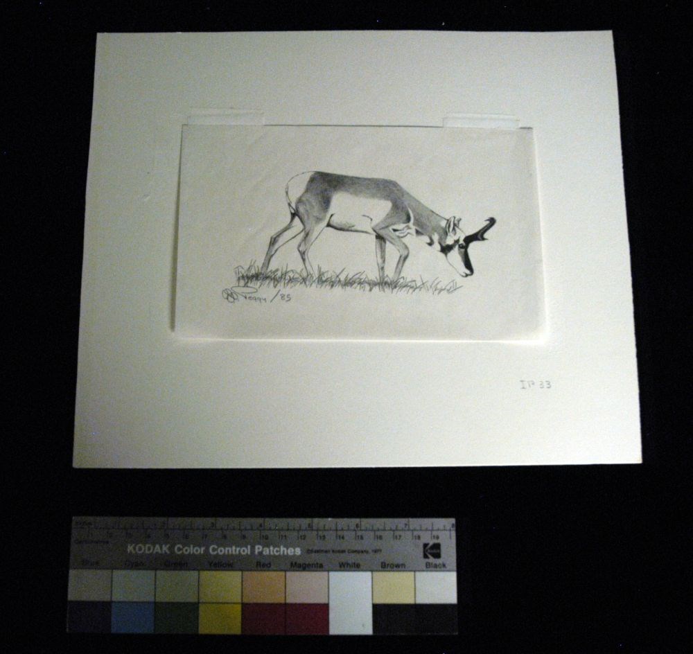
- Artist
- Peggy Dixon
- Date
- 1985
- Medium
- graphite on paper
- Catalogue Number
- DiP.03.04
- Description
- An antelope faces to the right in fully body profile. Grass lines the bottom of the image. At the lower right corner of the matt “IP 33.” On the back of the image is an erased sketch of a person riding a horse on the right, and a person holding a rope on the left.
1 image
- Artist
- Peggy Dixon
- Title
- Antelope Buck
- Date
- 1985
- Medium
- graphite on paper
- Dimensions
- 12.5 x 20.3 cm
- Description
- An antelope faces to the right in fully body profile. Grass lines the bottom of the image. At the lower right corner of the matt “IP 33.” On the back of the image is an erased sketch of a person riding a horse on the right, and a person holding a rope on the left.
- Credit
- Gift of Peggy Dixon, Milk River, 2012
- Catalogue Number
- DiP.03.04
Images
This material is presented as originally created; it may contain outdated cultural descriptions and
potentially offensive content.
Read more.
Argonaut Mountain, Kootenay Land District, British Columbia
https://archives.whyte.org/en/permalink/catalogue23451
- Medium
- Library - Maps and blueprints (unannotated; published)
- Map
- Published Date
- 1980
- Publisher
- Ottawa: Surveys and Mapping Branch, Dept. of Energy, Mines and Resources
- Edition
- 2d ed.
- Call Number
- NTS
- 82M/16
- Edition
- 2d ed.
- Publisher
- Ottawa: Surveys and Mapping Branch, Dept. of Energy, Mines and Resources
- Published Date
- 1980
- Physical Description
- 1 map : col
- Scale
- Scale: 1:50,000
- Subjects
- Argonaut Mountain
- British Columbia
- Accession Number
- 27,000
- 7030
- Call Number
- NTS
- 82M/16
- Collection
- Archives Library
This material is presented as originally created; it may contain outdated cultural descriptions and
potentially offensive content.
Read more.
[Athabaska Pass]
https://archives.whyte.org/en/permalink/catalogue23456
- Medium
- Library - Maps and blueprints (unannotated; published)
- Map
- Published Date
- 1980
- Publisher
- Dept. of Energy, Mines and Resources
- Edition
- Edition 2
- Call Number
- NTS
- 83D/8
- Edition
- Edition 2
- Publisher
- Dept. of Energy, Mines and Resources
- Published Date
- 1980
- Physical Description
- 1 map : col
- Scale
- Scale: 1:50,000
- Relief: Contour Interval 100 ft.
- Subjects
- Athabaska Pass
- Notes
- National Topographic System
- Accession Number
- 13,000
- Call Number
- NTS
- 83D/8
- Collection
- Archives Library
This material is presented as originally created; it may contain outdated cultural descriptions and
potentially offensive content.
Read more.
Azure River 83D/12 B.C.
https://archives.whyte.org/en/permalink/catalogue23459
- Medium
- Library - Maps and blueprints (unannotated; published)
- Map
- Published Date
- 1986
- Publisher
- Surveys and Mapping Branch, Dept. of Energy, Mines and Resources
- Edition
- 3rd ed.
- Call Number
- NTS
- 83D/12
- Edition
- 3rd ed.
- Publisher
- Surveys and Mapping Branch, Dept. of Energy, Mines and Resources
- Published Date
- 1986
- Physical Description
- 1 map : col
- Scale
- Scale: 1:50,000
- Relief: Contour interval 100 feet.
- Subjects
- Azure River
- British Columbia
- Notes
- National Topographic System
- Accession Number
- 19,000
- Call Number
- NTS
- 83D/12
- Collection
- Archives Library
This material is presented as originally created; it may contain outdated cultural descriptions and
potentially offensive content.
Read more.
Banff land use bylaw
https://archives.whyte.org/en/permalink/catalogue23276
- Medium
- Library - Maps and blueprints (unannotated; published)
- Map
- Published Date
- November 13, 1989
- Call Number
- C4-1.19
- Responsibility
- sgd. Barlow et al.
- Published Date
- November 13, 1989
- Physical Description
- 1 map
- Scale
- Scale: 1 : 5,000
- Subjects
- Banff townsite
- Call Number
- C4-1.19
- Collection
- Archives Library
This material is presented as originally created; it may contain outdated cultural descriptions and
potentially offensive content.
Read more.
Banff natureguide : natural history and trail information, including maps of Banff Townsite & vicinity, Bow Valley area, Mountain Parks region
https://archives.whyte.org/en/permalink/catalogue23409
- Medium
- Library - Maps and blueprints (unannotated; published)
- Map
- Published Date
- 1983
- Publisher
- Calgary : Blackbird Naturographics
- Call Number
- C6-6.1b
- Publisher
- Calgary : Blackbird Naturographics
- Published Date
- 1983
- Physical Description
- 5 maps on 1 sheet : col
- Scale
- Scales vary
- Accession Number
- 16,500
- Call Number
- C6-6.1b
- Collection
- Archives Library
This material is presented as originally created; it may contain outdated cultural descriptions and
potentially offensive content.
Read more.
Banff natureguide : natural history and trail information, including maps of Banff Townsite & vicinity, Bow Valley area, Mountain Parks region
https://archives.whyte.org/en/permalink/catalogue24342
- Medium
- Library - Maps and blueprints (unannotated; published)
- Map
- Published Date
- 1983
- Publisher
- Calgary : Blackbird Naturographics
- Call Number
- C6-6.1b
- Publisher
- Calgary : Blackbird Naturographics
- Published Date
- 1983
- Physical Description
- 5 maps on 1 sheet : col
- Scale
- Scales vary
- Accession Number
- 16,500
- Call Number
- C6-6.1b
- Collection
- Archives Library
This material is presented as originally created; it may contain outdated cultural descriptions and
potentially offensive content.
Read more.
Belcourt Lake, British Columbia
https://archives.whyte.org/en/permalink/catalogue23495
- Medium
- Library - Maps and blueprints (unannotated; published)
- Map
- Published Date
- 1986
- Publisher
- Ottawa : Surveys and Mapping Branch
- Call Number
- NTS
- 93I/8
- Publisher
- Ottawa : Surveys and Mapping Branch
- Published Date
- 1986
- Physical Description
- 1 map : col
- Scale
- Scale: 1:50,000
- Accession Number
- 24,000
- Call Number
- NTS
- 93I/8
- Collection
- Archives Library
This material is presented as originally created; it may contain outdated cultural descriptions and
potentially offensive content.
Read more.
- Date
- 1985
- Medium
- graphite on paper
- Catalogue Number
- KaP.03.03
- Description
- A Bighorn Ram is standing on a slope which has tall grasses; he is facing to the left.
- Title
- Bighorn Ram
- Date
- 1985
- Medium
- graphite on paper
- Dimensions
- 15.0; 27.0 x 12.0; 35.3 cm
- Description
- A Bighorn Ram is standing on a slope which has tall grasses; he is facing to the left.
- Subject
- animal, sheep
- Bighorn Sheep
- Credit
- Gift of Peter Karsten, Calgary, 1985
- Catalogue Number
- KaP.03.03
This material is presented as originally created; it may contain outdated cultural descriptions and
potentially offensive content.
Read more.
Blue Creek, Alberta
https://archives.whyte.org/en/permalink/catalogue23502
- Medium
- Library - Maps and blueprints (unannotated; published)
- Map
- Published Date
- 1981
- Publisher
- [Ottawa]: Surveys an Mapping Branch, Dept. of Energy, Mines and Resources
- Edition
- 3rd edition
- Call Number
- NTS
- 83E/7
- Edition
- 3rd edition
- Publisher
- [Ottawa]: Surveys an Mapping Branch, Dept. of Energy, Mines and Resources
- Published Date
- 1981
- Physical Description
- 1 map : col
- Scale
- 1:50,000
- Accession Number
- 27,000
- Call Number
- NTS
- 83E/7
- Collection
- Archives Library
This material is presented as originally created; it may contain outdated cultural descriptions and
potentially offensive content.
Read more.
Blue River 83D/3 B.C.
https://archives.whyte.org/en/permalink/catalogue23507
- Medium
- Library - Maps and blueprints (unannotated; published)
- Map
- Published Date
- 1986
- Publisher
- Surveys and Mapping Branch, Dept. of Energy, Mines and Resources
- Edition
- 3rd ed.
- Call Number
- NTS
- 83D/3
- Edition
- 3rd ed.
- Publisher
- Surveys and Mapping Branch, Dept. of Energy, Mines and Resources
- Published Date
- 1986
- Physical Description
- 1 map : col
- Scale
- Scale: 1:50,000
- Relief: Contour interval 100 feet
- Subjects
- Blue River
- British Columbia
- Notes
- National Topographic System
- Accession Number
- 19,000
- Call Number
- NTS
- 83D/3
- Collection
- Archives Library
This material is presented as originally created; it may contain outdated cultural descriptions and
potentially offensive content.
Read more.