Narrow Results By
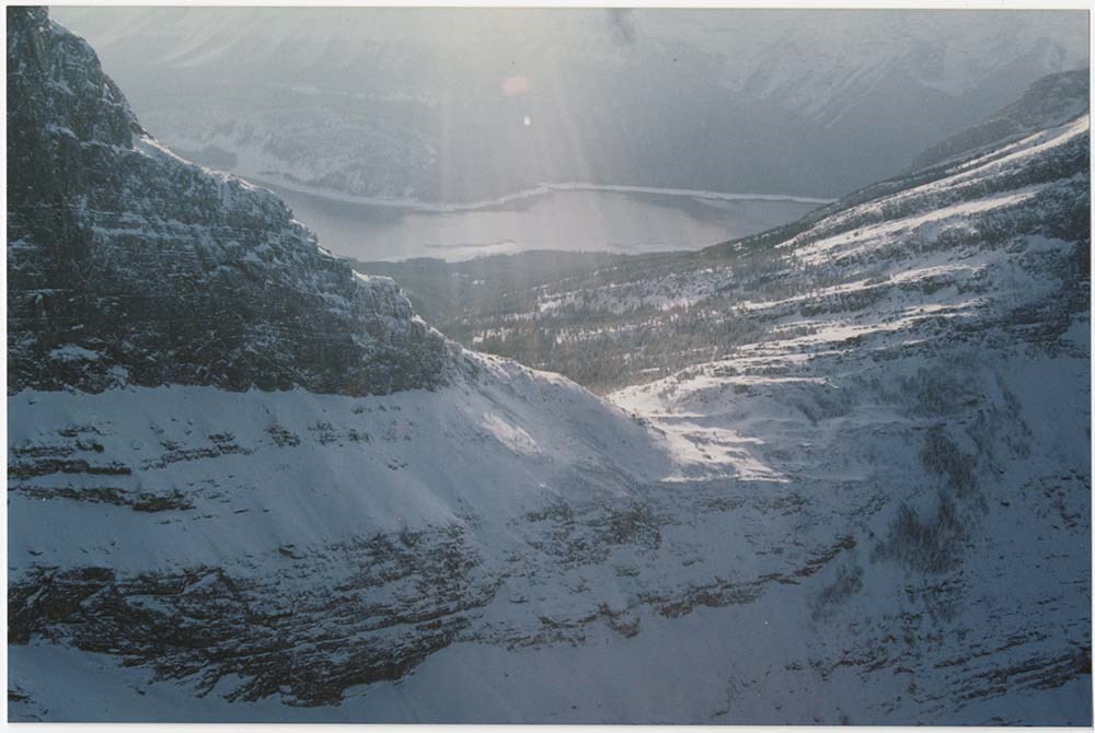
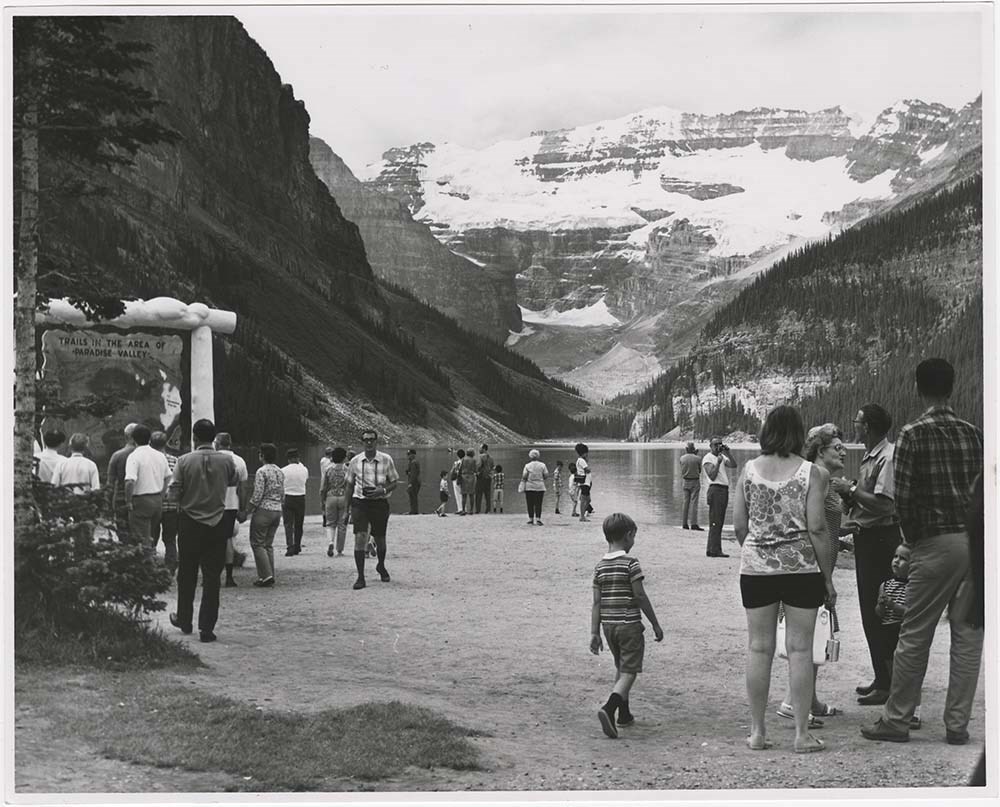
Kinney Lake and Berg Lake trail signs
https://archives.whyte.org/en/permalink/descriptions56329
- Part Of
- Ben Gadd fonds
- Scope & Content
- File consists of photographs depicting landscape and mountain views, plant species, and interpretive trail signs near Kinney Lake and Berg Lake.
- Date Range
- 1996
- Reference Code
- V810 / III / D / NA - 14 to 29
- Description Level
- 5 / File
- GMD
- Photograph
- Part Of
- Ben Gadd fonds
- Description Level
- 5 / File
- Fonds Number
- M590
- V810
- S61
- Series
- V810 / III : Professional records
- Sous-Fonds
- V810
- Sub-Series
- V810 / III / D : Other contracts and projects
- Accession Number
- 2021.20
- Reference Code
- V810 / III / D / NA - 14 to 29
- GMD
- Photograph
- Responsibility
- Produced by Ben Gadd
- Date Range
- 1996
- Physical Description
- 62 photographs : 16 col. negative film strips ; 35mm
- Scope & Content
- File consists of photographs depicting landscape and mountain views, plant species, and interpretive trail signs near Kinney Lake and Berg Lake.
- Name Access
- Gadd, Ben
- Subject Access
- Environment
- Landscape
- Guiding
- Tourist information
- Trails
- Geographic Access
- Canada
- Alberta
- Reproduction Restrictions
- Restrictions may apply
- Language
- English
- Related Material
- V810/III/D/PA-39 to 85
- Category
- Environment
- Tourism
- Title Source
- Title based on contents of file
- Processing Status
- Processed
This material is presented as originally created; it may contain outdated cultural descriptions and
potentially offensive content.
Read more.
Lake Louise Area
https://archives.whyte.org/en/permalink/descriptions54925
- Part Of
- Murray Hay fonds
- Scope & Content
- File consists of 6 prints : col. ; 25.5 x 20 cm or smaller. File pertains to Murray Hay's renderings of the Lake Louise ski area. File includes six reproduced draft prints of original paintings of the Lake Louise ski area created by Murray Hay (different iterations).
- Date Range
- ca.1976-ca.2000
- Reference Code
- V795 / II / B / ii / 1
- Description Level
- 5 / File
- GMD
- Map
- Private record
- Part Of
- Murray Hay fonds
- Description Level
- 5 / File
- Fonds Number
- M570 / V795
- Series
- V795 / I : Unpublished Material
- Sous-Fonds
- V795
- Sub-Series
- V795 / I / B : Alberta / ii : Lake Louise
- Accession Number
- 2019.41
- Reference Code
- V795 / II / B / ii / 1
- GMD
- Map
- Private record
- Date Range
- ca.1976-ca.2000
- Physical Description
- 6 prints : col. ; 25.5 x 20 cm or smaller
- Scope & Content
- File consists of 6 prints : col. ; 25.5 x 20 cm or smaller. File pertains to Murray Hay's renderings of the Lake Louise ski area. File includes six reproduced draft prints of original paintings of the Lake Louise ski area created by Murray Hay (different iterations).
- Name Access
- Hay, Murray
- Subject Access
- Advertising
- Artist
- Ski Maps
- Map
- Cartography
- Sports and recreation
- Tourism
- Tourist information
- Winter
- Winter sports
- Ski area
- Lake Louise Ski Area
- Geographic Access
- Lake Louise
- Alberta
- Canada
- Canadian Rocky Mountains
- Language
- English
- Related Material
- M570 / III / B / ii / 1-2
- Creator
- Hay, Murray
- Title Source
- Title based on contents of file
- Processing Status
- Processed
This material is presented as originally created; it may contain outdated cultural descriptions and
potentially offensive content.
Read more.
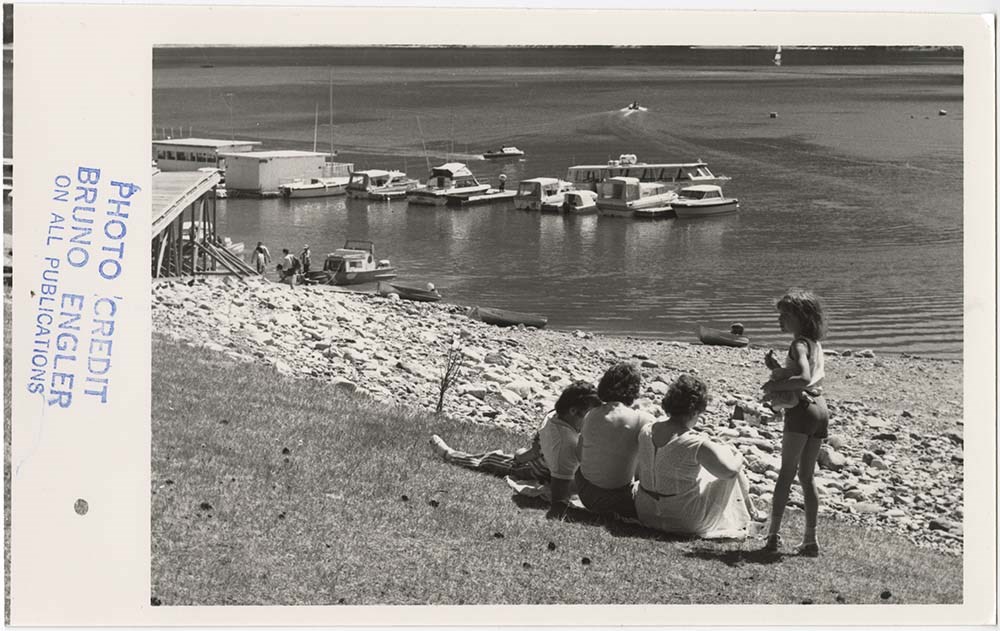
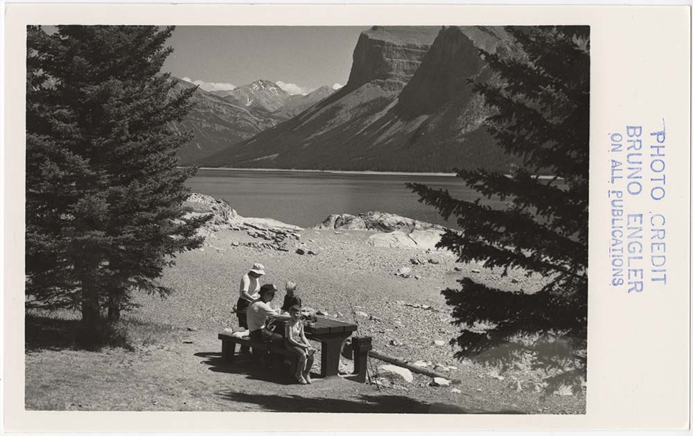
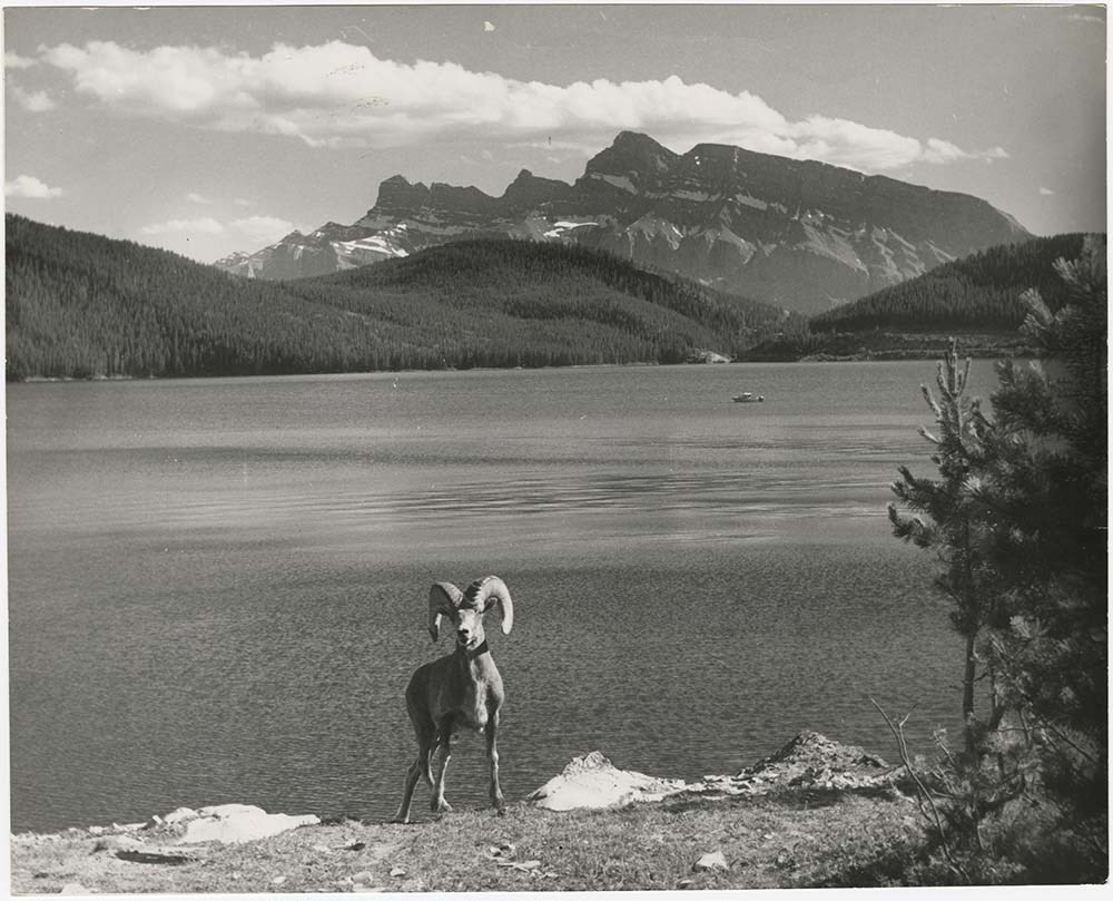
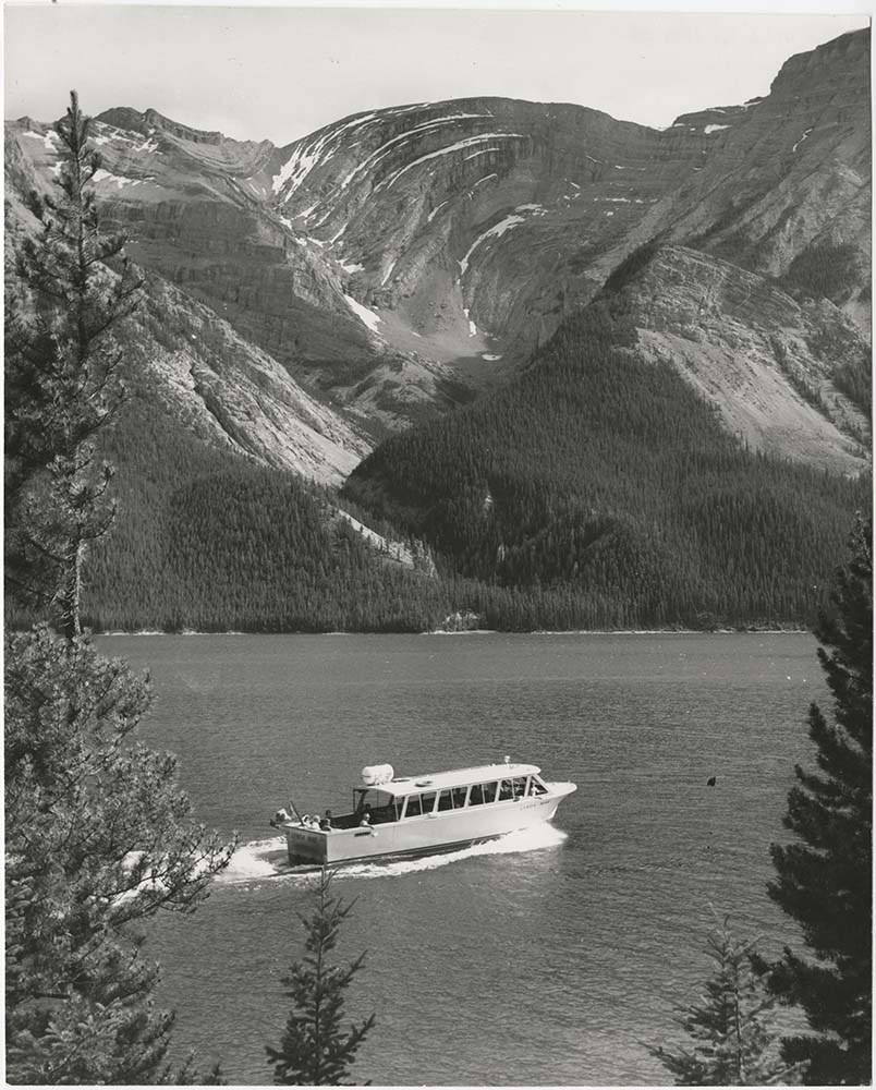
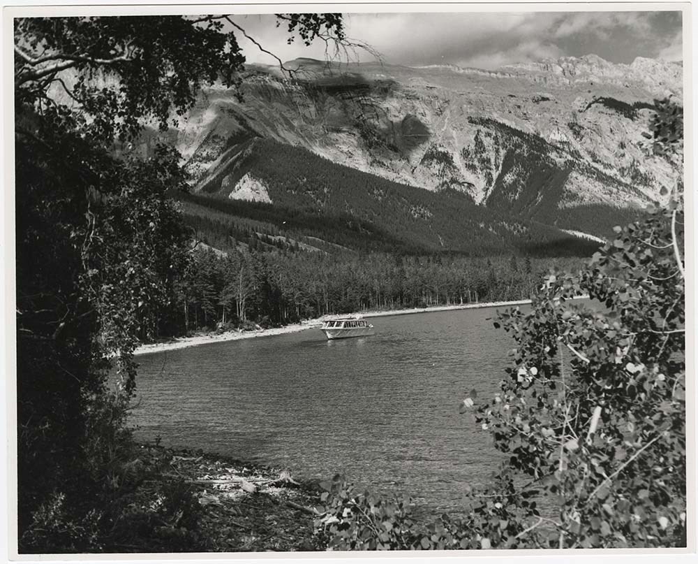
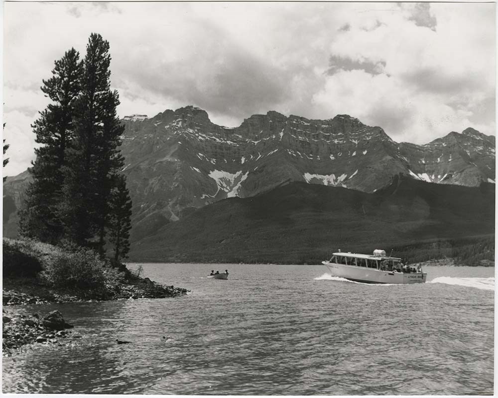
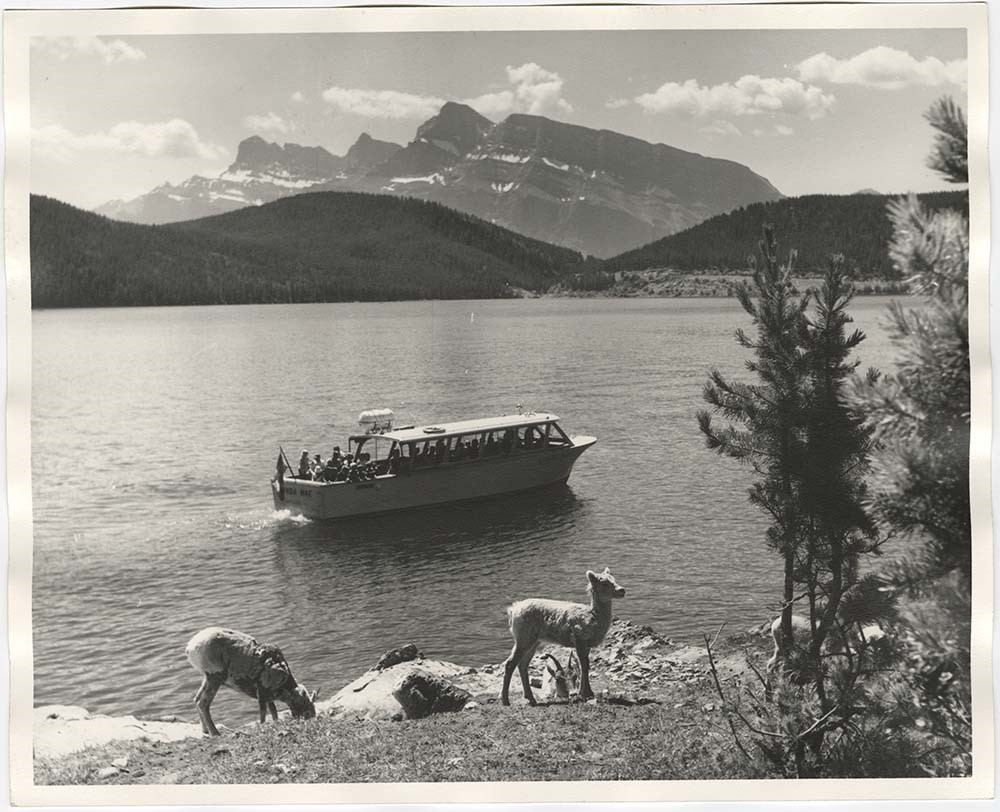
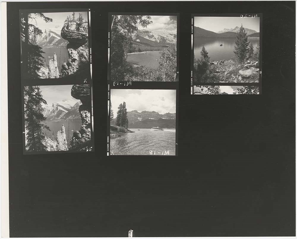
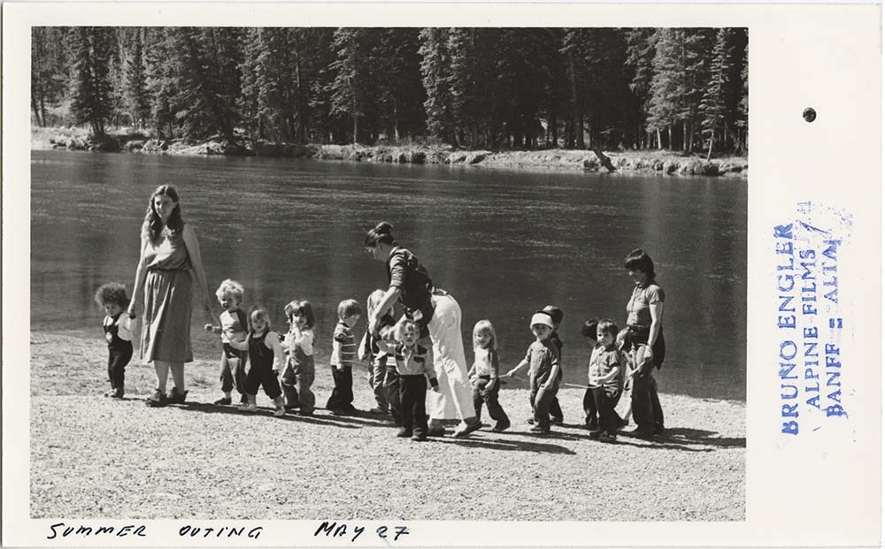
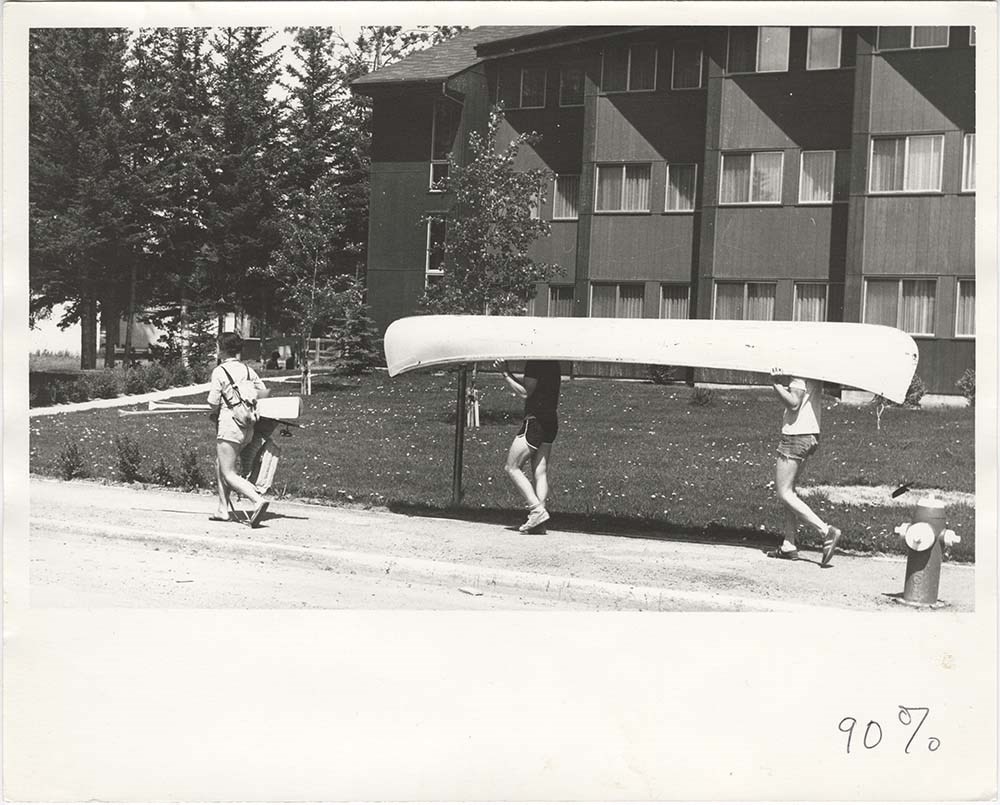
Lake Minnewanka
https://archives.whyte.org/en/permalink/descriptions56928
- Part Of
- Bruno Engler fonds
- Scope & Content
- File pertains to 10 b&w prints of Lake Minnewanka. Includes mostly images of tour boats on the lake, some with big horn sheep in the foreground - also includes one contact sheet.
- Date Range
- 1973
- Reference Code
- V190 / VI / L / ii / PA - 01 to PA - 10
- Description Level
- 5 / File
- GMD
- Photograph
10 images
- Part Of
- Bruno Engler fonds
- Description Level
- 5 / File
- Fonds Number
- M323 / S40 / V190
- Series
- VI : Retained file, L : Alphabetical order
- Sous-Fonds
- V190
- Sub-Series
- ii : Lake Minnewanka
- Accession Number
- 7436
- Reference Code
- V190 / VI / L / ii / PA - 01 to PA - 10
- GMD
- Photograph
- Date Range
- 1973
- Physical Description
- 10 photographs : b&w ; 25.2 x 20.2 cm or smaller
- History / Biographical
- See fonds level description
- Scope & Content
- File pertains to 10 b&w prints of Lake Minnewanka. Includes mostly images of tour boats on the lake, some with big horn sheep in the foreground - also includes one contact sheet.
- Subject Access
- Animals
- Big Horn Sheep
- Boats
- Lake Minnewanka
- Tourism
- Geographic Access
- Banff National Park
- Alberta
- Language
- English
- Related Material
- V190 / VI / L / ii / NA - 01 to NA - 03
- Creator
- Engler, Bruno
- Title Source
- Original title kept
- Processing Status
- Processed
Images


This material is presented as originally created; it may contain outdated cultural descriptions and
potentially offensive content.
Read more.
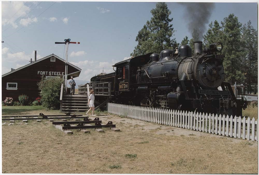
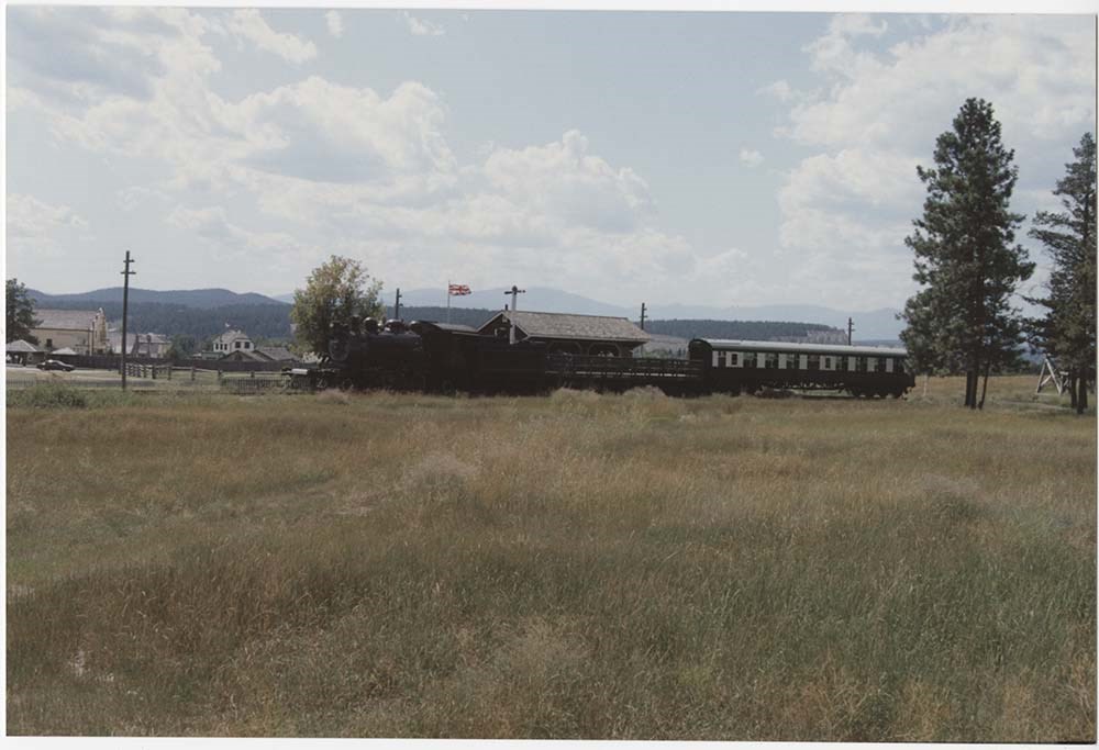
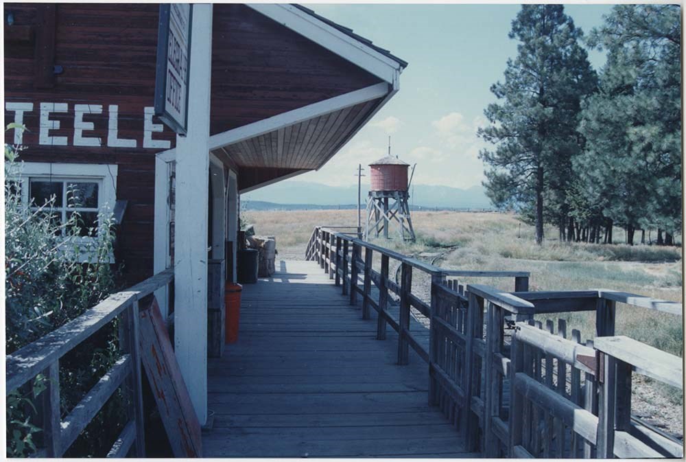
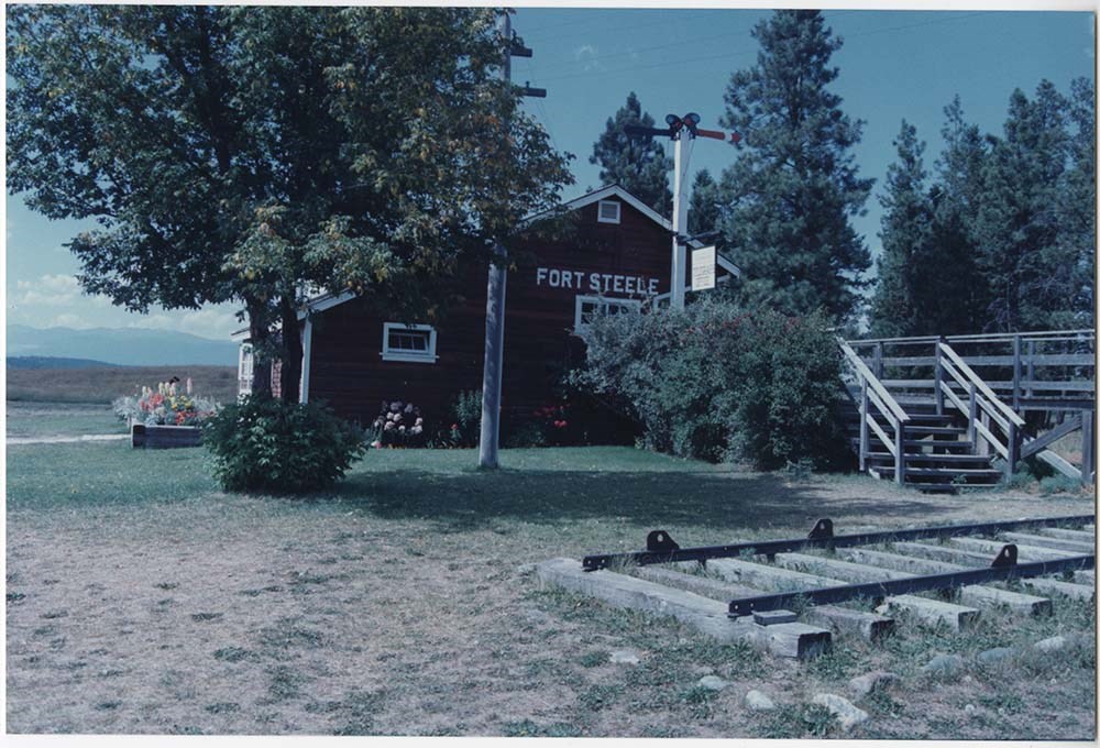
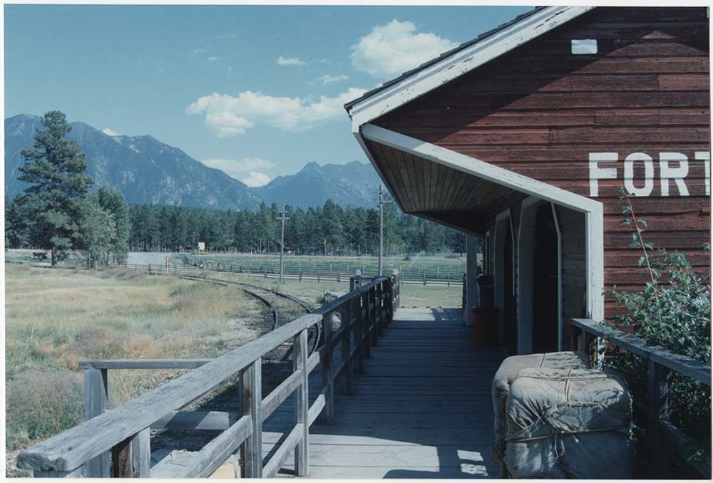
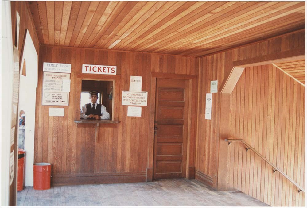
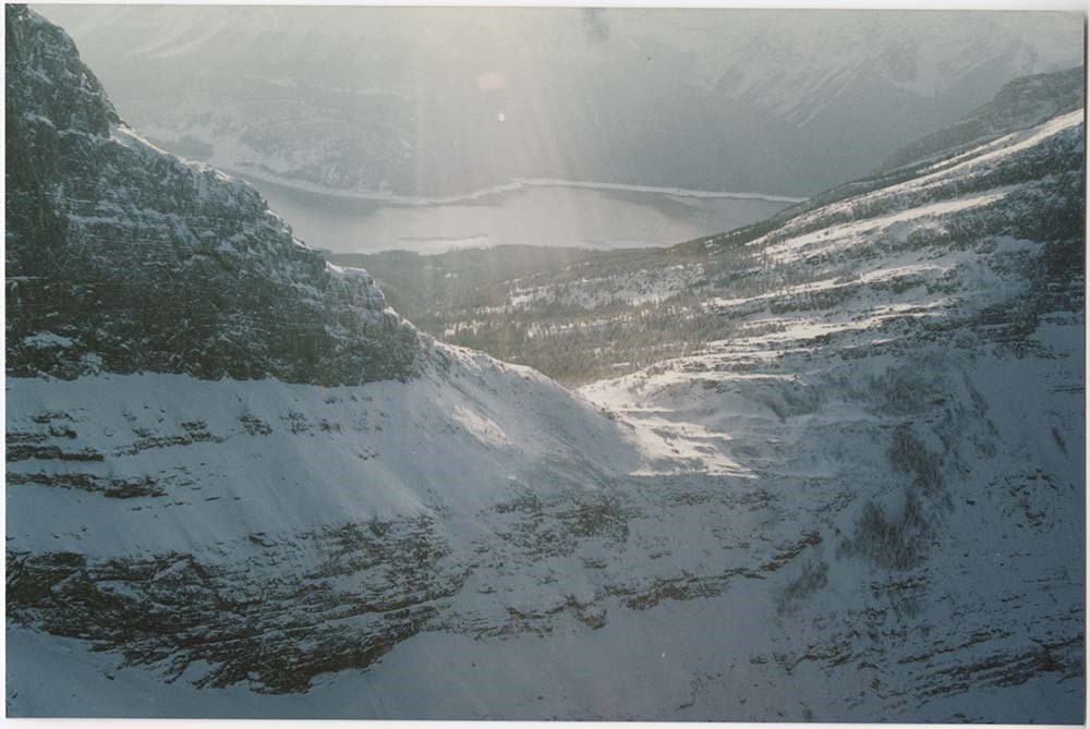
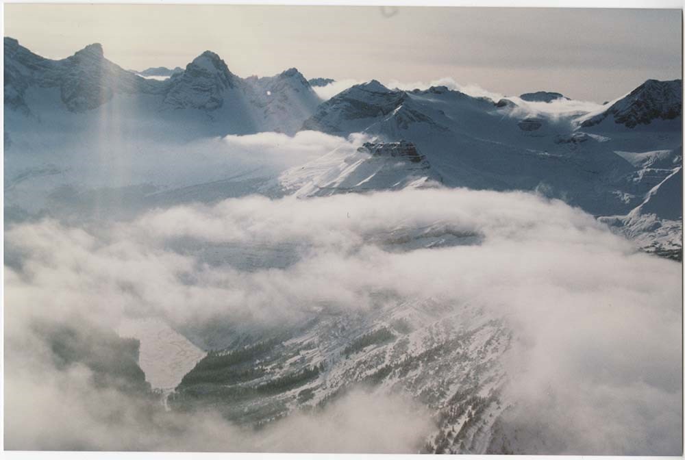
Location & Scenic [2/5]
https://archives.whyte.org/en/permalink/descriptions57136
- Part Of
- Bruno Engler fonds
- Scope & Content
- File pertains to 107 colour prints of various locations. Includes Fort Steele Locations [taken in 1991 at the same site as a 1952 shoot], wildlife, the interiors of several log houses [mostly fireplaces], the Badlands and Milk River, and various parts of Kananaskis, including Haig Glacier and Wind …
- Date Range
- 1988-1992
- Reference Code
- V190 / VI / L / v / PA - 52 to PA - 159
- Description Level
- 5 / File
- GMD
- Photograph
12 images
- Part Of
- Bruno Engler fonds
- Description Level
- 5 / File
- Fonds Number
- M323 / S40 / V190
- Series
- VI : Retained file, L : Alphabetical order
- Sous-Fonds
- V190
- Sub-Series
- v : Location & Scenic: Cliffhanger, Imax, etc
- Accession Number
- 7436
- Reference Code
- V190 / VI / L / v / PA - 52 to PA - 159
- GMD
- Photograph
- Date Range
- 1988-1992
- Physical Description
- 107 photographs : col. ; 15.2 x 10.1 cm
- History / Biographical
- See fonds level description
- Scope & Content
- File pertains to 107 colour prints of various locations. Includes Fort Steele Locations [taken in 1991 at the same site as a 1952 shoot], wildlife, the interiors of several log houses [mostly fireplaces], the Badlands and Milk River, and various parts of Kananaskis, including Haig Glacier and Wind Pass, taken from the air in 1991.
- Subject Access
- Animals
- Automobiles
- Badlands
- Buildings
- Cabins
- Filmaking
- Films and film making
- Helicopters
- Mountains
- Rivers
- Scenery
- Tourism
- Trains
- Winter
- Geographic Access
- Banff National Park
- Kananaskis Country
- Alberta
- Language
- English
- Related Material
- V190 / VI / L / v / NA - 64 to NA - 97
- Creator
- Engler, Bruno
- Title Source
- Original title kept
- Processing Status
- Processed
Images


This material is presented as originally created; it may contain outdated cultural descriptions and
potentially offensive content.
Read more.
- Part Of
- Murray Hay fonds
- Scope & Content
- File consists of 2 prints : col. ; 35 x 28 cm. File pertains to Murray Hay's rendering of Marmot Basin ski area in Jasper National Park. File includes two iterations of reproduction draft prints of Hay's map of Marmot Basin.
- Date Range
- ca.1976-ca.2000
- Reference Code
- V795 / II / B / i / 1
- Description Level
- 5 / File
- GMD
- Map
- Private record
- Part Of
- Murray Hay fonds
- Description Level
- 5 / File
- Fonds Number
- M570 / V795
- Series
- V795 / II : Unpublished Material
- Sous-Fonds
- V795
- Sub-Series
- V795 / II / B : Alberta / i : Jasper National Park
- Accession Number
- 2019.41
- Reference Code
- V795 / II / B / i / 1
- GMD
- Map
- Private record
- Date Range
- ca.1976-ca.2000
- Physical Description
- 2 prints : col. ; 35 x 28 cm
- Scope & Content
- File consists of 2 prints : col. ; 35 x 28 cm. File pertains to Murray Hay's rendering of Marmot Basin ski area in Jasper National Park. File includes two iterations of reproduction draft prints of Hay's map of Marmot Basin.
- Name Access
- Hay, Murray
- Subject Access
- Advertising
- Artist
- Ski Maps
- Ski area
- Map
- Cartography
- Sports and recreation
- Tourism
- Tourist information
- Winter
- Winter sports
- Geographic Access
- Jasper Marmot Basin
- Jasper National Park
- Alberta
- Canada
- Canadian Rocky Mountains
- Language
- English
- Related Material
- M570 / III / B / iii / 1
- Creator
- Hay, Murray
- Title Source
- Title based on contents of file
- Processing Status
- Processed
This material is presented as originally created; it may contain outdated cultural descriptions and
potentially offensive content.
Read more.
- Part Of
- Murray Hay fonds
- Scope & Content
- File consists of 5 prints : b&w and col. ; 38 x 26.5 cm or smaller. FIle pertains to Murray Hay's work on different maps for a variety of places in British Columbia, Canada. File includes three draft prints of different iterations of the ski trails at the Fairmont Hot Springs resort; a map labelled…
- Date Range
- ca.1976-ca.2000
- Reference Code
- V795 / II / A / viii / 1-3
- Description Level
- 5 / File
- GMD
- Private record
- Map
- Part Of
- Murray Hay fonds
- Description Level
- 5 / File
- Fonds Number
- M570 / V795
- Series
- V795 / II : Unpublished Material
- Sous-Fonds
- V795
- Sub-Series
- V795 / II / A : British Columbia / viii : Miscellaneous
- Accession Number
- 2019.41
- Reference Code
- V795 / II / A / viii / 1-3
- GMD
- Private record
- Map
- Date Range
- ca.1976-ca.2000
- Physical Description
- 5 prints : b&w and col. ; 38 x 26.5 cm or smaller
- Scope & Content
- File consists of 5 prints : b&w and col. ; 38 x 26.5 cm or smaller. FIle pertains to Murray Hay's work on different maps for a variety of places in British Columbia, Canada. File includes three draft prints of different iterations of the ski trails at the Fairmont Hot Springs resort; a map labelled in pencil (on the back of the print) "Cypress Bowl Cross Country Ski Map - Vancouver", and a map glued or otherwise attached to a piece of white board labelled in blue ink "Blue River Heli Ski Area (approximately the size of Belgium."
- Name Access
- Hay, Murray
- Subject Access
- Advertising
- Artist
- Ski area
- Ski Maps
- Map
- Cartography
- Sports and recreation
- Tourism
- Tourist information
- Helicopter skiing
- Winter
- Winter sports
- Geographic Access
- Vancouver
- Fairmont Hot Springs
- Blue River Resort
- British Columbia
- Canada
- Language
- English
- Conservation
- Adhesives should be removed and alternative preservation methods should be used.
- Related Material
- M570 / III / A / vi / 1
- Creator
- Hay, Murray
- Title Source
- Title based on contents of file
- Processing Status
- Processed
This material is presented as originally created; it may contain outdated cultural descriptions and
potentially offensive content.
Read more.
- Part Of
- Murray Hay fonds
- Scope & Content
- File consists of 4 maps, 2 prints, and 3 paintings, 60 x 30 cm or smaller. File pertains to a variety of maps Murray Hay created for Equinox Magazine in the 1980s. File includes original paintings (Middle East, Jamaica, North Atlantic Ocean/Europe area), two reproduced prints (South Korea Olympic a…
- Date Range
- ca.1980-ca.1989
- Reference Code
- V795 / II / D / ii / 4-6
- Description Level
- 5 / File
- GMD
- Painting
- Private record
- Map
- Part Of
- Murray Hay fonds
- Description Level
- 5 / File
- Fonds Number
- M570 / V795
- Series
- V795 / II : Unpublished Material
- Sous-Fonds
- V795
- Sub-Series
- V795 / II / D : International / ii : Miscellaneous
- Accession Number
- 2019.41
- 2020.03
- Reference Code
- V795 / II / D / ii / 4-6
- Date Range
- ca.1980-ca.1989
- Physical Description
- 4 maps (4 overlays) : col., annotations
- 2 prints : col. ; 36 x 28 cm
- 3 paintings ; 60 x 30 cm or smaller
- Scope & Content
- File consists of 4 maps, 2 prints, and 3 paintings, 60 x 30 cm or smaller. File pertains to a variety of maps Murray Hay created for Equinox Magazine in the 1980s. File includes original paintings (Middle East, Jamaica, North Atlantic Ocean/Europe area), two reproduced prints (South Korea Olympic area), and other maps (coloured red) with overlays (Nepal and the Caribbean).
- Notes
- Items not in oversize stored in downstairs vault.
- Name Access
- Hay, Murray
- Subject Access
- Advertising
- Artist
- Map
- Cartography
- Tourism
- Tourist information
- Travel
- Geography
- Olympic Games (Winter)
- Geographic Access
- South Korea
- Nepal
- Caribbean
- Mexico
- Belize
- Jamaica
- Europe
- Canada
- Middle East
- India
- Russia
- Language
- English
- Creator
- Hay, Murray
- Category
- Arts
- Exploration, discovery and travel
- Title Source
- Title based on contents of file
- Processing Status
- Processed
This material is presented as originally created; it may contain outdated cultural descriptions and
potentially offensive content.
Read more.
Panorama Mountain Resort & Heli-Ski Area
https://archives.whyte.org/en/permalink/descriptions54884
- Part Of
- Murray Hay fonds
- Scope & Content
- File consists of 3 prints : col. ; 35 x 35 cm and 35 x 28 cm. File pertains to Murray Hay's various renderings of the Panorama ski and heli-ski areas in Invermere, British Columbia. File includes two reproduced draft prints of the Panorama Heli-Ski Area and one reproduced draft print of the Panoram…
- Date Range
- ca.1976-ca.2000
- Reference Code
- V795 / II / A / vii / 1
- Description Level
- 5 / File
- GMD
- Map
- Private record
- Part Of
- Murray Hay fonds
- Description Level
- 5 / File
- Fonds Number
- M570 / V795
- Series
- V795 / II : Unpublished Material
- Sous-Fonds
- V795
- Sub-Series
- V795 / II / A : British Columbia / vii : Invermere
- Accession Number
- 2019.41
- Reference Code
- V795 / II / A / vii / 1
- GMD
- Map
- Private record
- Date Range
- ca.1976-ca.2000
- Physical Description
- 3 prints : col. ; 35 x 35 cm and 35 x 28 cm
- Scope & Content
- File consists of 3 prints : col. ; 35 x 35 cm and 35 x 28 cm. File pertains to Murray Hay's various renderings of the Panorama ski and heli-ski areas in Invermere, British Columbia. File includes two reproduced draft prints of the Panorama Heli-Ski Area and one reproduced draft print of the Panorama Ski Area (each print is labelled in ink).
- Name Access
- Hay, Murray
- Subject Access
- Art
- Artist
- Ski Maps
- Map
- Cartography
- Sports and recreation
- Tourism
- Tourist information
- Helicopter skiing
- Winter
- Winter sports
- Ski area
- Geographic Access
- Panorama
- British Columbia
- Canada
- Invermere
- Language
- English
- Related Material
- M570 / III / A / iii / 1-2
- Creator
- Hay, Murray
- Title Source
- Title based on contents of file
- Processing Status
- Processed
This material is presented as originally created; it may contain outdated cultural descriptions and
potentially offensive content.
Read more.
Pembina River Provincial Park
https://archives.whyte.org/en/permalink/descriptions56397
- Part Of
- Ben Gadd fonds
- Scope & Content
- File consists of photographs taken by Ben Gadd during a trip to Pembina River Provincial Park, including winter views of hiking trails and forested areas.
- Date Range
- 1997
- Reference Code
- V810 / III / D / PA - 173 to 180
- Description Level
- 5 / File
- GMD
- Photograph
- Part Of
- Ben Gadd fonds
- Description Level
- 5 / File
- Fonds Number
- M590
- V810
- S61
- Series
- V810 / III : Professional records
- Sous-Fonds
- V810
- Sub-Series
- V810 / III / D : Other contracts and projects
- Accession Number
- 2021.20
- Reference Code
- V810 / III / D / PA - 173 to 180
- GMD
- Photograph
- Responsibility
- Produced by Ben Gadd
- Date Range
- 1997
- Physical Description
- 8 photographs : col. prints ; 10 x 15 cm
- Scope & Content
- File consists of photographs taken by Ben Gadd during a trip to Pembina River Provincial Park, including winter views of hiking trails and forested areas.
- Name Access
- Gadd, Ben
- Subject Access
- Tourism
- Tourist information
- Hiking
- Recreation
- Trails
- Provincial parks and reserves
- Geographic Access
- Canada
- British Columbia
- Pembina River Provincial Park
- Language
- N/A
- Category
- Tourism
- Sports, recreation and leisure
- Title Source
- Original title used
- Processing Status
- Processed
This material is presented as originally created; it may contain outdated cultural descriptions and
potentially offensive content.
Read more.
Powder King Ski Village
https://archives.whyte.org/en/permalink/descriptions54878
- Part Of
- Murray Hay fonds
- Scope & Content
- File consists of 4 prints : col. ; 35 x 28 cm or smaller. File pertains to Murray Hay's rendering of the lift system at Powder King Ski Village in British Columbia. File includes different iterations of a map of the lift system, all reproduced as draft prints.
- Date Range
- ca.1980-ca.1985
- ca.1983
- Reference Code
- V795 / II / A / v / 1-2
- Description Level
- 5 / File
- GMD
- Map
- Private record
- Part Of
- Murray Hay fonds
- Description Level
- 5 / File
- Fonds Number
- M570 / V795
- Series
- V795 / II : Unpublished Material
- Sous-Fonds
- V795
- Sub-Series
- V795 / II / A : British Columbia / v : Powder King Mountain Resort
- Accession Number
- 2019.41
- Reference Code
- V795 / II / A / v / 1-2
- GMD
- Map
- Private record
- Date Range
- ca.1980-ca.1985
- ca.1983
- Physical Description
- 4 prints : col. ; 35 x 28 cm or smaller
- Scope & Content
- File consists of 4 prints : col. ; 35 x 28 cm or smaller. File pertains to Murray Hay's rendering of the lift system at Powder King Ski Village in British Columbia. File includes different iterations of a map of the lift system, all reproduced as draft prints.
- Notes
- The ski hill was renamed Powder King in 1983.
- One of the prints in V795 / II / A / v / 1 include a sticky note with annotations and has comments on the actual print itself in red ink.
- Name Access
- Hay, Murray
- Subject Access
- Advertising
- Art
- Artist
- Ski Maps
- Map
- Cartography
- Sports and recreation
- Tourism
- Tourist information
- Winter
- Winter sports
- Ski area
- Powder King Mountain Resort
- Geographic Access
- British Columbia
- Canada
- Powder King Mountain Resort
- Language
- English
- Creator
- Hay, Murray
- Title Source
- Title based on contents of file
- Processing Status
- Processed
This material is presented as originally created; it may contain outdated cultural descriptions and
potentially offensive content.
Read more.
Prince Edward Island
https://archives.whyte.org/en/permalink/descriptions54968
- Part Of
- Murray Hay fonds
- Scope & Content
- File consists of 11 prints : col. ; 28.5 x 22 cm and 15 x 10 cm. File pertains to Murray Hay's cartographic/lanscape renderings of various portions of Prince Edward Island, Canada that were created for Reader's Digest, "Book of the Road." File includes reproduced photographic prints of original pai…
- Date Range
- ca.1976 - ca. 2000
- Reference Code
- V795 / II / C / ii / 1
- Description Level
- 5 / File
- GMD
- Map
- Private record
- Part Of
- Murray Hay fonds
- Description Level
- 5 / File
- Fonds Number
- M570 / V795
- Series
- V795 / II : Unpublished Material
- Sous-Fonds
- V795
- Sub-Series
- V795 / II / C : Canada [general] / ii : Prince Edward Island
- Accession Number
- 2019.41
- Reference Code
- V795 / II / C / ii / 1
- GMD
- Map
- Private record
- Date Range
- ca.1976 - ca. 2000
- Physical Description
- 11 prints : col. ; 28.5 x 22 cm and 15 x 10 cm
- Scope & Content
- File consists of 11 prints : col. ; 28.5 x 22 cm and 15 x 10 cm. File pertains to Murray Hay's cartographic/lanscape renderings of various portions of Prince Edward Island, Canada that were created for Reader's Digest, "Book of the Road." File includes reproduced photographic prints of original paintings that Hay created, including 3 of prints arranged on a piece of paper with original notes written in pencil by Hay.
- Notes
- Some of the prints include annotations.
- Name Access
- Hay, Murray
- Subject Access
- Advertising
- Artist
- Landscapes
- Map
- Cartography
- Tourism
- Geography
- Geographic Access
- Prince Edward Island
- Canada
- Language
- English
- Conservation
- There is masking tape and double sided tape holding the photographs together, which should be removed and alternative preservation methods should be considered at a reasonable time to do so.
- Creator
- Hay, Murray
- Title Source
- Title based on contents of file
- Processing Status
- Processed
This material is presented as originally created; it may contain outdated cultural descriptions and
potentially offensive content.
Read more.
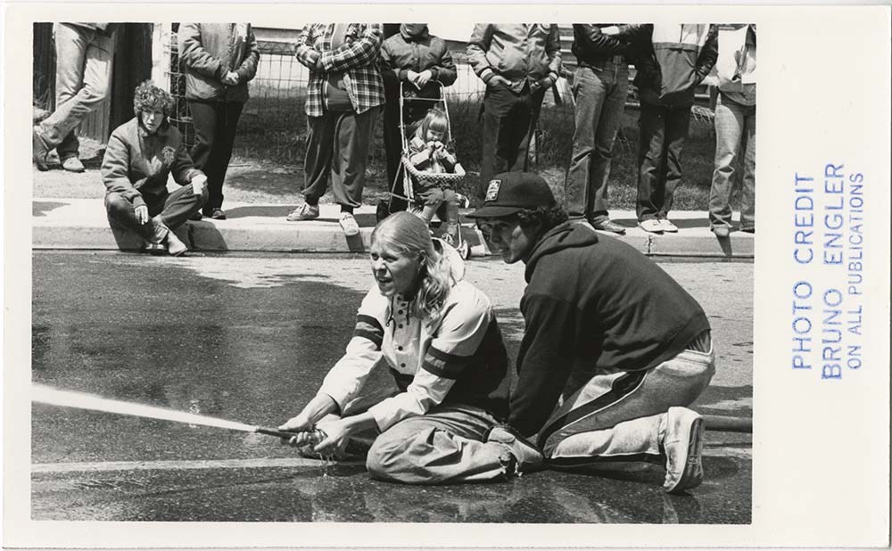
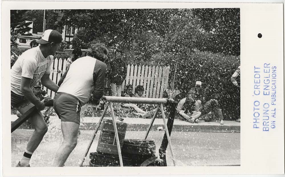
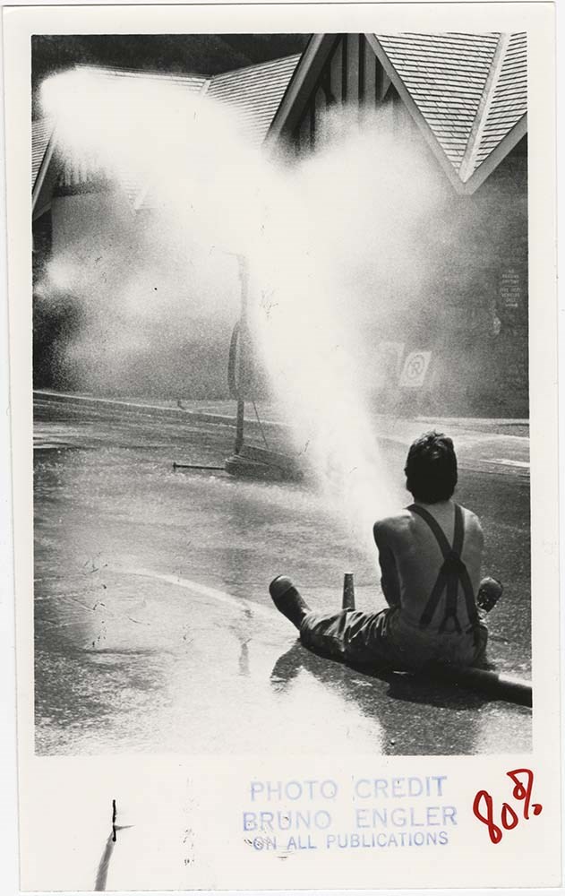
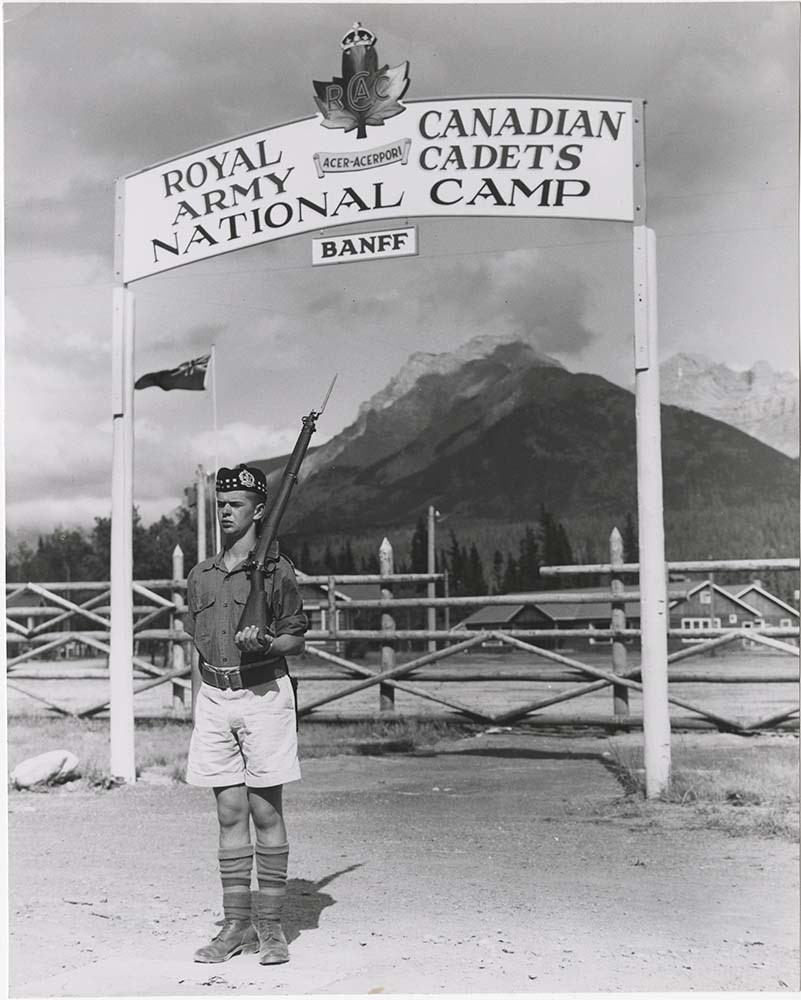
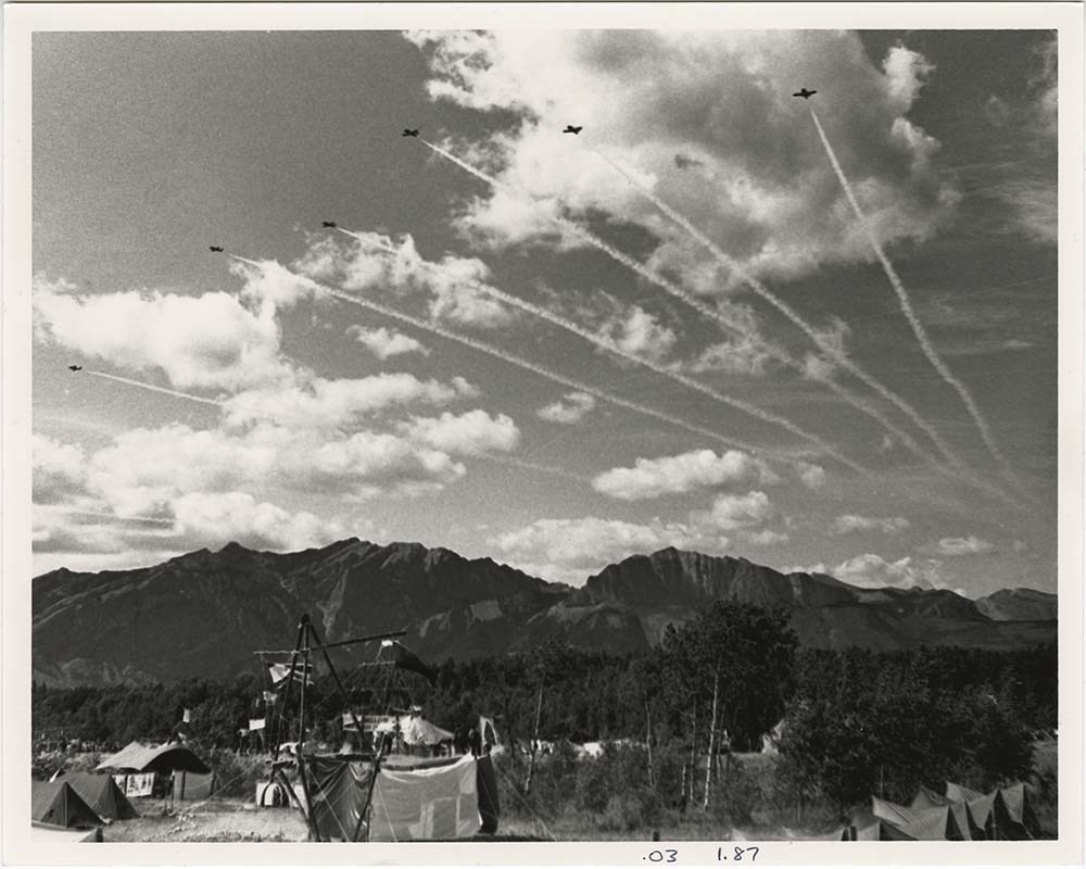
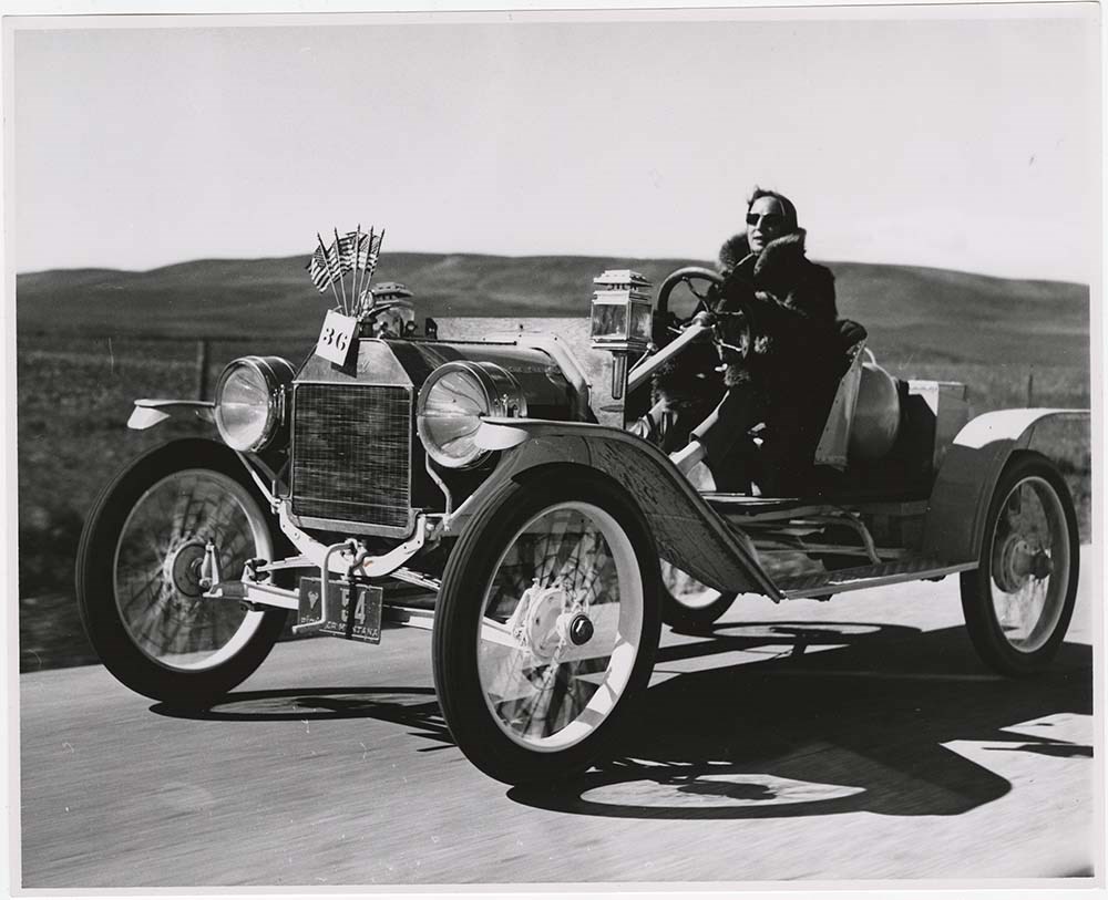
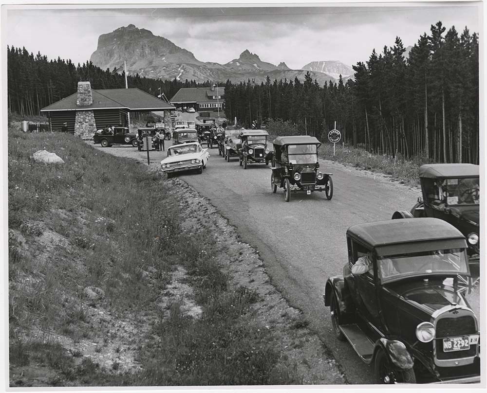
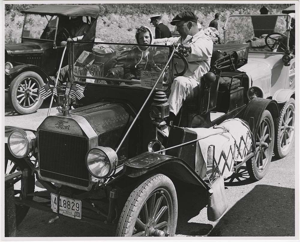
Publication Photos
https://archives.whyte.org/en/permalink/descriptions57424
- Part Of
- Bruno Engler fonds
- Scope & Content
- File pertains to 60 b&w prints of various events, groups, and individuals - mostly unidentified - possibly for the purpose of publication. Includes the Banff Boy Scouts, Banff Air Cadets, a firefighting competion on Banff Avenue, climbing, sunbathers, mountain and glacier scenes, Lake Louise, Bow L…
- Date Range
- 1961-1983
- Reference Code
- V190 / VI / P / viii / PA - 01 to PA - 60
- Description Level
- 5 / File
- GMD
- Photograph
14 images
- Part Of
- Bruno Engler fonds
- Description Level
- 5 / File
- Fonds Number
- M323 / S40 / V190
- Series
- VI : Retained file, P : Alphabetical order
- Sous-Fonds
- V190
- Sub-Series
- viii : Publication Photos
- Accession Number
- 7436
- Reference Code
- V190 / VI / P / viii / PA - 01 to PA - 60
- GMD
- Photograph
- Date Range
- 1961-1983
- Physical Description
- 60 photographs : b&w ; 25.2 x 20.2 cm or smaller
- History / Biographical
- See fonds level description
- Scope & Content
- File pertains to 60 b&w prints of various events, groups, and individuals - mostly unidentified - possibly for the purpose of publication. Includes the Banff Boy Scouts, Banff Air Cadets, a firefighting competion on Banff Avenue, climbing, sunbathers, mountain and glacier scenes, Lake Louise, Bow Lake, airplanes and air shows, and members of the Montana Rocky Mountain Model T Ford Club.
- Notes
- PA - 01 to 08 pertain to the [Boy] Scout Jamboree in Kananaskis, 1983. PA - 09 to 19 pertain to a Banff Fireman Show, 1982.
- Subject Access
- Airplane
- Airplanes
- Automobiles
- Banff Centre
- Banff Flying Club
- Cadet camp
- Ceremony
- Children
- Climbing
- Comptetions
- Family
- Fire fighters
- Fire fighting equipment
- Mountaineering
- Mountaineers
- Mountains
- Personal and Family Life
- Personal and Professional Life
- Portrait
- Tourism
- Geographic Access
- Bow Lake
- Lake Louise
- Banff
- Banff National Park
- Kananaskis Country
- Alberta
- Language
- English
- Creator
- Engler, Bruno
- Title Source
- Original title kept
- Processing Status
- Processed
Images


This material is presented as originally created; it may contain outdated cultural descriptions and
potentially offensive content.
Read more.
Silver Star Mountain Resort
https://archives.whyte.org/en/permalink/descriptions54873
- Part Of
- Murray Hay fonds
- Scope & Content
- File consists of 1 map (1 base, 4 overlays) : col., annotations, on mylar ; 85 x 62 cm, and 1 print : col. ; 35 x 28 cm. FIle pertains to Murray Hay's creation of ski maps for Silver Star Mountain Resort in Vernon, British Columbia. File includes two oversize, colour prints: one (V795 / II / A / i…
- Date Range
- ca.1980-ca.1983
- Reference Code
- V795 / II / A / iv / 1-2
- Description Level
- 5 / File
- GMD
- Map
- Private record
- Part Of
- Murray Hay fonds
- Description Level
- 5 / File
- Fonds Number
- M570 / V795
- Series
- V795 / II : Unpublished Material
- Sous-Fonds
- V795
- Sub-Series
- V795 / II / A : British Columbia / iv : Okanagan Area
- Accession Number
- 2019.41
- Reference Code
- V795 / II / A / iv / 1-2
- GMD
- Map
- Private record
- Date Range
- ca.1980-ca.1983
- Physical Description
- 1 map (1 base, 4 overlays) : col., annotations, on mylar ; 85 x 62 cm
- 1 print : col. ; 35 x 28 cm
- Scope & Content
- File consists of 1 map (1 base, 4 overlays) : col., annotations, on mylar ; 85 x 62 cm, and 1 print : col. ; 35 x 28 cm. FIle pertains to Murray Hay's creation of ski maps for Silver Star Mountain Resort in Vernon, British Columbia. File includes two oversize, colour prints: one (V795 / II / A / iv / 1) is a basic, unlabelled map of the ski area; and the other (V795 / II / A / iv / 2) is a larger draft with overlays (held together with masking tape on a piece of thick white paper).
- Notes
- V795 / II / A / iv / 2 : has "16490" and "Hold" written in pencil on the masking tape. Also has some red marker on the bottom edge and near the legend.
- Name Access
- Hay, Murray
- Subject Access
- Ski area
- Ski Maps
- Map
- Cartography
- Sports and recreation
- Tourism
- Tourist information
- Winter
- Winter sports
- Silver Star
- Advertising
- Artist
- Geographic Access
- Vernon
- British Columbia
- Canada
- Monashee Mountains
- Silver Star Provincial Park
- Language
- English
- Conservation
- The masking tape should be removed and alternative preservation methods should be considered at a reasonable time to do so.
- Overlays are loose.
- Related Material
- M570 / III / A / i / 1
- Creator
- Hay, Murray
- Title Source
- Title based on contents of file
- Processing Status
- Processed
This material is presented as originally created; it may contain outdated cultural descriptions and
potentially offensive content.
Read more.
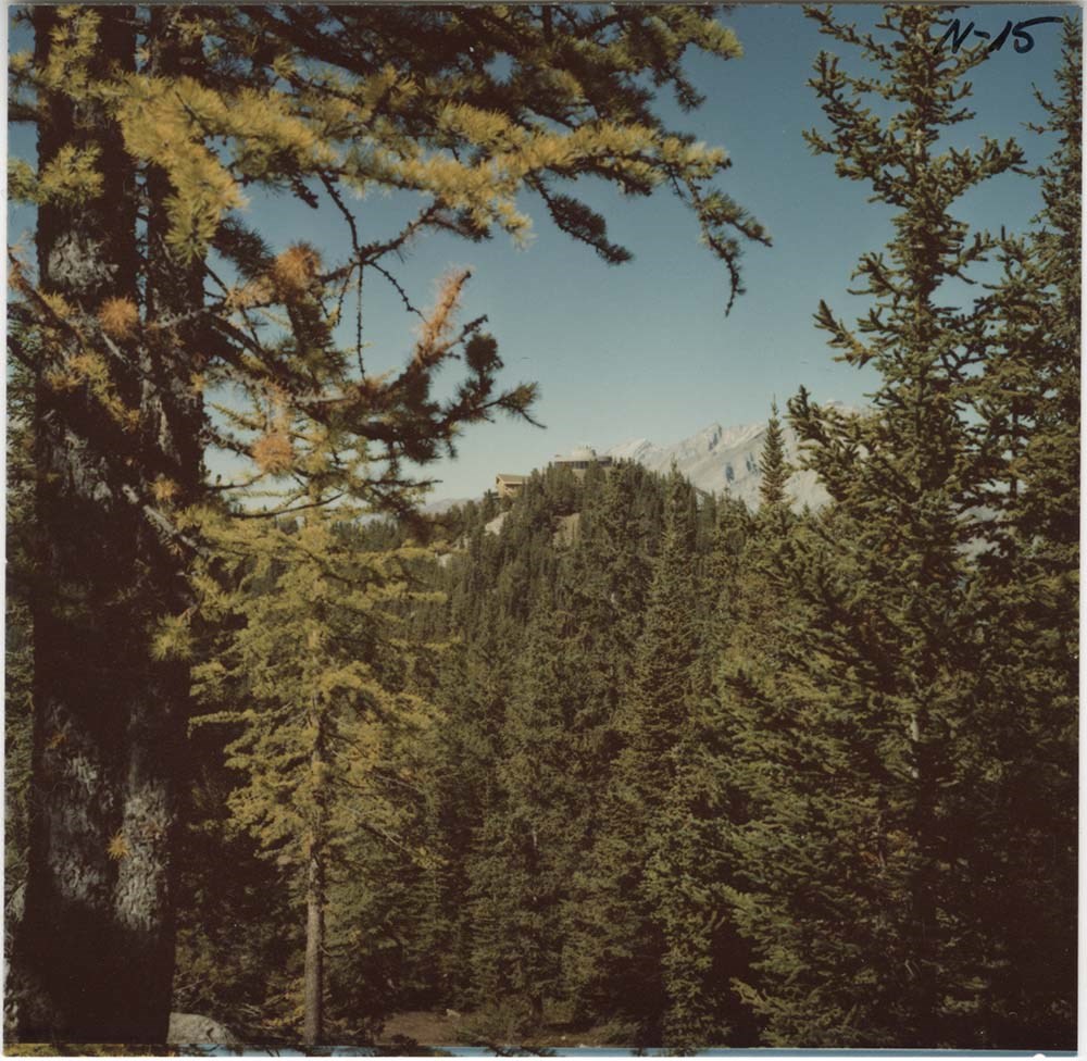
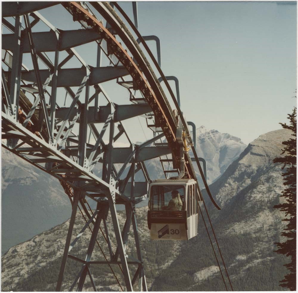
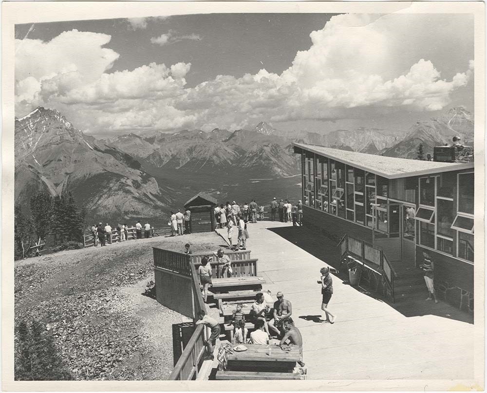
Sulphur Mountain Gondola
https://archives.whyte.org/en/permalink/descriptions57465
- Part Of
- Bruno Engler fonds
- Scope & Content
- File pertains to 49 b&w & colour prints of Sulphur Mountain, the Gondola Upper Terminal, hiking trail, and gondola cars & cables, as well as misceleaneous shots of the Banff townsight and construction of the skating rink and bridge at the base of Norquay Mountain.
- Date Range
- [ca. 1960-1973]
- Reference Code
- V190 / VI / S / iv / PA - 01 to PA - 49
- Description Level
- 5 / File
- GMD
- Photograph
10 images
- Part Of
- Bruno Engler fonds
- Description Level
- 5 / File
- Fonds Number
- M323 / S40 / V190
- Series
- VI : Retained file, S : Alphabetical order
- Sous-Fonds
- V190
- Sub-Series
- iv : Sulphur Mountain Gondola
- Accession Number
- 7436
- Reference Code
- V190 / VI / S / iv / PA - 01 to PA - 49
- GMD
- Photograph
- Date Range
- [ca. 1960-1973]
- Physical Description
- 49 photographs : b&w & col. ; 25.2 x 20.2 cm or smaller
- History / Biographical
- See fonds level description
- Scope & Content
- File pertains to 49 b&w & colour prints of Sulphur Mountain, the Gondola Upper Terminal, hiking trail, and gondola cars & cables, as well as misceleaneous shots of the Banff townsight and construction of the skating rink and bridge at the base of Norquay Mountain.
- Subject Access
- Activities
- Banff townsite
- Children
- Construction
- Gondolas
- Helicopters
- Hiking
- Mountains
- Mount Norquay Ski Area
- Norquay Ski Hill
- Scenery
- Ski areas
- Skiing
- Sulphur Mountain
- Sulphur Mountain Gondola
- Sulphur Mountain lookout
- Summit
- Tourism
- Winter
- Winter sports
- Geographic Access
- Banff
- Banff National Park
- Alberta
- Language
- English
- Related Material
- V190 / VI / S / iv / NA - 01 to NA - 04 V190 / VI / S / iv / NS - 01 to NS - 03
- Creator
- Engler, Bruno
- Title Source
- Original title kept
- Processing Status
- Processed
Images


This material is presented as originally created; it may contain outdated cultural descriptions and
potentially offensive content.
Read more.
Sulphur Mountain Gondola - transparencies
https://archives.whyte.org/en/permalink/descriptions57467
- Part Of
- Bruno Engler fonds
- Scope & Content
- File pertains to 64 colour transparencies of Sulphur Mountain, the Gondola Upper Terminal, restaurant , hiking trail, views from the peak, and gondola cars & cables.
- Date Range
- [ca. 1960-1973]
- Reference Code
- V190 / VI / S / iv / NS - 01 to NS - 04
- Description Level
- 5 / File
- GMD
- Photograph
- Part Of
- Bruno Engler fonds
- Description Level
- 5 / File
- Fonds Number
- M323 / S40 / V190
- Series
- VI : Retained file, S : Alphabetical order
- Sous-Fonds
- V190
- Sub-Series
- iv : Sulphur Mountain Gondola
- Accession Number
- 7436
- Reference Code
- V190 / VI / S / iv / NS - 01 to NS - 04
- GMD
- Photograph
- Date Range
- [ca. 1960-1973]
- Physical Description
- 64 photographs : col. slides ; medium format
- History / Biographical
- See fonds level description
- Scope & Content
- File pertains to 64 colour transparencies of Sulphur Mountain, the Gondola Upper Terminal, restaurant , hiking trail, views from the peak, and gondola cars & cables.
- Subject Access
- Activities
- Banff townsite
- Children
- Gondolas
- Hiking
- Mountains
- Scenery
- Sulphur Mountain
- Sulphur Mountain Gondola
- Sulphur Mountain lookout
- Summit
- Tourism
- Winter
- Geographic Access
- Banff
- Banff National Park
- Alberta
- Language
- English
- Related Material
- V190 / VI / S / iv / PA - 01 to PA - 49 V190 / VI / S / iv / NA - 01 to NA - 04
- Creator
- Engler, Bruno
- Title Source
- Original title kept
- Processing Status
- Processed
This material is presented as originally created; it may contain outdated cultural descriptions and
potentially offensive content.
Read more.
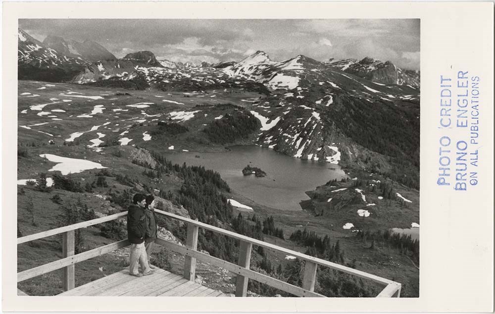
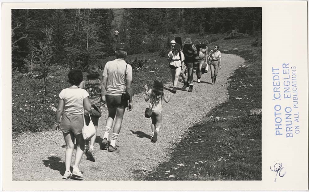
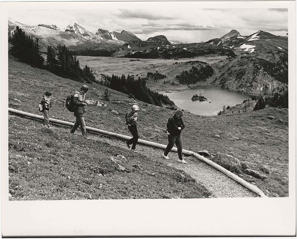
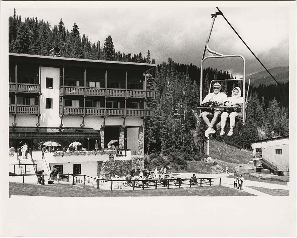
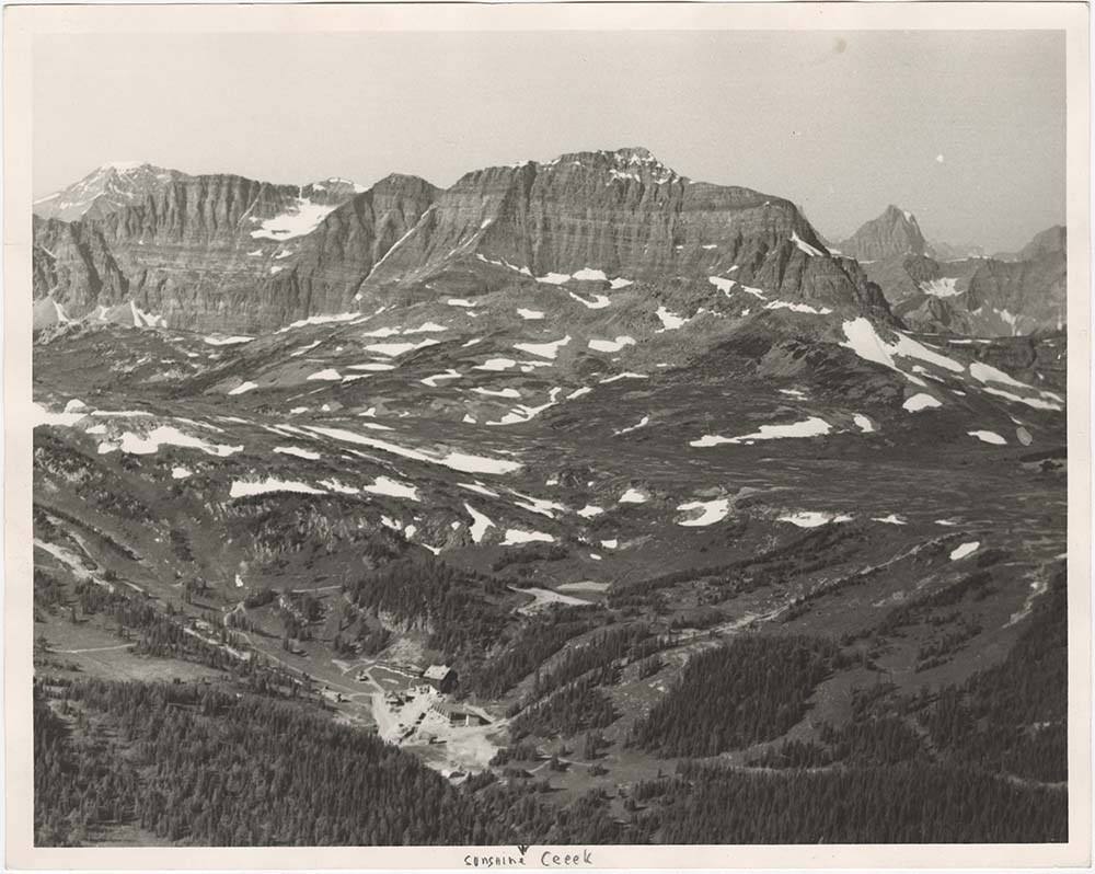
Sunshine Summer
https://archives.whyte.org/en/permalink/descriptions57471
- Part Of
- Bruno Engler fonds
- Scope & Content
- File pertains to 14 b&w prints of the Sunshine Ski Resort area during the summer, including people on hiking trails, the Standish Mountain viewing platform looking over Sunshine Meadows and the lakes, people on the Standish chairlift with the hotel in the background, and various surrounding mountai…
- Date Range
- 1986
- Reference Code
- V190 / VI / S / v / c / PA - 01 to PA - 14
- Description Level
- 5 / File
- GMD
- Photograph
7 images
- Part Of
- Bruno Engler fonds
- Description Level
- 5 / File
- Fonds Number
- M323 / S40 / V190
- Series
- VI : Retained file, S : Alphabetical order
- Sous-Fonds
- V190
- Sub-Series
- v : Sunshine, c : Summer
- Accession Number
- 7436
- Reference Code
- V190 / VI / S / v / c / PA - 01 to PA - 14
- GMD
- Photograph
- Date Range
- 1986
- Physical Description
- 14 photographs : b&w & col. ; 25.2 x 20.2 cm or smaller
- History / Biographical
- See fonds level description
- Scope & Content
- File pertains to 14 b&w prints of the Sunshine Ski Resort area during the summer, including people on hiking trails, the Standish Mountain viewing platform looking over Sunshine Meadows and the lakes, people on the Standish chairlift with the hotel in the background, and various surrounding mountains. Also includes one colour contact sheet of negatives [or possibly transparencies].
- Subject Access
- Buildings
- Chairlifts and gondolas
- Children
- Family and personal life
- Gondolas
- Hiking
- Mountains
- Scenery
- Ski areas
- Sunshine Meadows
- Sunshine Ski Resort
- Sunshine Village
- Tourism
- Geographic Access
- Banff National Park
- Alberta
- Language
- English
- Related Material
- V190 / VI / S / v / c / NA - 01 to NA - 04 V190 / VI / S / v / c / NS - 01
- Creator
- Engler, Bruno
- Title Source
- Original title kept
- Processing Status
- Processed
Images


This material is presented as originally created; it may contain outdated cultural descriptions and
potentially offensive content.
Read more.
Sunshine Summer - negatives
https://archives.whyte.org/en/permalink/descriptions57472
- Part Of
- Bruno Engler fonds
- Scope & Content
- File pertains to 53 b&w & colour negatives on 22 strips of film depicting the Sunshine Ski Resort area during the summer, including people on hiking trails, the Standish Mountain viewing platform looking over Sunshine Meadows and the lakes, people on the Standish chairlift with the hotel in the bac…
- Date Range
- 1986
- Reference Code
- V190 / VI / S / v / c / NA - 01 to NA - 04
- Description Level
- 5 / File
- GMD
- Photograph
- Part Of
- Bruno Engler fonds
- Description Level
- 5 / File
- Fonds Number
- M323 / S40 / V190
- Series
- VI : Retained file, S : Alphabetical order
- Sous-Fonds
- V190
- Sub-Series
- v : Sunshine, c : Summer
- Accession Number
- 7436
- Reference Code
- V190 / VI / S / v / c / NA - 01 to NA - 04
- GMD
- Photograph
- Date Range
- 1986
- Physical Description
- 53 photographs : b&w & col. slides ; medium format or smaller
- History / Biographical
- See fonds level description
- Scope & Content
- File pertains to 53 b&w & colour negatives on 22 strips of film depicting the Sunshine Ski Resort area during the summer, including people on hiking trails, the Standish Mountain viewing platform looking over Sunshine Meadows and the lakes, people on the Standish chairlift with the hotel in the background, and various surrounding mountains. Also includes aerial shots taken during a flight with Murray Hay, as well as posed portraits from that trip, most likely for a ski map project.
- Name Access
- Hay, Murray
- Subject Access
- Aerial photography
- Buildings
- Chairlifts and gondolas
- Children
- Family and personal life
- Gondolas
- Hiking
- Mountains
- Scenery
- Ski areas
- Sunshine Meadows
- Sunshine Ski Resort
- Sunshine Village
- Tourism
- Geographic Access
- Banff National Park
- Alberta
- Language
- English
- Related Material
- V190 / VI / S / v / c / PA - 01 to PA - 14 V190 / VI / S / v / c / NS - 01
- Creator
- Engler, Bruno
- Title Source
- Original title kept
- Processing Status
- Processed
This material is presented as originally created; it may contain outdated cultural descriptions and
potentially offensive content.
Read more.
Sunshine Summer - transparencies
https://archives.whyte.org/en/permalink/descriptions57473
- Part Of
- Bruno Engler fonds
- Scope & Content
- File pertains to 13 colour transparencies on 6 strips of film depicting the Sunshine Ski Resort area during the summer, including some kind of community picnic at the hotel, Rock Isle Lake seen from the Standish Mountain viewing platform, trees, and flowers.
- Date Range
- 1986
- Reference Code
- V190 / VI / S / v / c / NS - 01
- Description Level
- 5 / File
- GMD
- Photograph
- Part Of
- Bruno Engler fonds
- Description Level
- 5 / File
- Fonds Number
- M323 / S40 / V190
- Series
- VI : Retained file, S : Alphabetical order
- Sous-Fonds
- V190
- Sub-Series
- v : Sunshine, c : Summer
- Accession Number
- 7436
- Reference Code
- V190 / VI / S / v / c / NS - 01
- GMD
- Photograph
- Date Range
- 1986
- Physical Description
- 13 photographs : col. slides ; medium format
- History / Biographical
- See fonds level description
- Scope & Content
- File pertains to 13 colour transparencies on 6 strips of film depicting the Sunshine Ski Resort area during the summer, including some kind of community picnic at the hotel, Rock Isle Lake seen from the Standish Mountain viewing platform, trees, and flowers.
- Subject Access
- Buildings
- Children
- Community events
- Community life
- Family and personal life
- Mountains
- Scenery
- Ski areas
- Sunshine Meadows
- Sunshine Ski Resort
- Sunshine Village
- Tourism
- Geographic Access
- Banff National Park
- Alberta
- Language
- English
- Related Material
- V190 / VI / S / v / c / PA - 01 to PA - 14 V190 / VI / S / v / c / NA - 01 to NA - 04
- Creator
- Engler, Bruno
- Title Source
- Original title kept
- Processing Status
- Processed
This material is presented as originally created; it may contain outdated cultural descriptions and
potentially offensive content.
Read more.
Sunshine Village
https://archives.whyte.org/en/permalink/descriptions54991
- Part Of
- Murray Hay fonds
- Scope & Content
- File consists of 9 prints : b&w and col. ; 35 x 28 cm or smaller, 2 maps (1 base, 4 overlays) : col., annotations, on mylar ; 26 x 35 cm and 23.5 x 31.5 cm, and 1 painting : landscape ; 46 x 43 cm. File pertains to ski trail maps and landscape maps/prints of Sunshine ski area created by Murray Hay.…
- Date Range
- ca.1980-ca.1999
- Reference Code
- V795 / II / B / vi / 1-3
- Description Level
- 5 / File
- GMD
- Map
- Painting
- Private record
- Part Of
- Murray Hay fonds
- Description Level
- 5 / File
- Fonds Number
- M570 / V795
- Series
- V795 / II : Unpublished Material
- Sous-Fonds
- V795
- Sub-Series
- V795 / II / B : Alberta / vi : Sunshine Village Ski Resort
- Accession Number
- 2019.41
- Reference Code
- V795 / II / B / vi / 1-3
- Date Range
- ca.1980-ca.1999
- Physical Description
- 9 prints : b&w and col. ; 35 x 28 cm or smaller
- 2 maps (1 base, 4 overlays) : col., annotations, on mylar ; 26 x 35 cm and 23.5 x 31.5 cm
- 1 painting : landscape ; 46 x 43 cm
- Scope & Content
- File consists of 9 prints : b&w and col. ; 35 x 28 cm or smaller, 2 maps (1 base, 4 overlays) : col., annotations, on mylar ; 26 x 35 cm and 23.5 x 31.5 cm, and 1 painting : landscape ; 46 x 43 cm. File pertains to ski trail maps and landscape maps/prints of Sunshine ski area created by Murray Hay. File includes 9 reproduced draft prints (various iterations), 2 reproduced maps with overlays held together with masking tape, and 1 original painting/drawing (unfinished).
- Name Access
- Hay, Murray
- Subject Access
- Advertising
- Artist
- Ski Maps
- Ski area
- Map
- Cartography
- Sports and recreation
- Tourism
- Tourist information
- Winter
- Winter sports
- Sunshine area
- Sunshine Village
- Sunshine Ski Resort
- Geographic Access
- Sunshine
- Alberta
- Canada
- Canadian Rocky Mountains
- Banff National Park
- Language
- English
- Related Material
- M570 / III / B / i / 1-2
- Creator
- Hay, Murray
- Title Source
- Title based on contents of file
- Processing Status
- Processed
This material is presented as originally created; it may contain outdated cultural descriptions and
potentially offensive content.
Read more.
- Part Of
- Ben Gadd fonds
- Scope & Content
- File consists of photographs depicting trails and interpretive signs in William A. Switzer Provincial Park. Ben Gadd worked as a consultant for the Government of Alberta in the production of updated interpretive signs in William A. Switzer Provincial Park between 1995 and 1996.
- Date Range
- [ca.1995]
- Reference Code
- V810 / III / D / PA - 181 to 215
- Description Level
- 5 / File
- GMD
- Photograph
- Part Of
- Ben Gadd fonds
- Description Level
- 5 / File
- Fonds Number
- M590
- V810
- S61
- Series
- V810 / III : Professional records
- Sous-Fonds
- V810
- Sub-Series
- V810 / III / D : Other contracts and projects
- Accession Number
- 2021.20
- Reference Code
- V810 / III / D / PA - 181 to 215
- GMD
- Photograph
- Responsibility
- Produced by Ben Gadd
- Date Range
- [ca.1995]
- Physical Description
- 35 photographs : col. prints ; 28 x 20 cm and 15 x 10 cm
- Scope & Content
- File consists of photographs depicting trails and interpretive signs in William A. Switzer Provincial Park. Ben Gadd worked as a consultant for the Government of Alberta in the production of updated interpretive signs in William A. Switzer Provincial Park between 1995 and 1996.
- Name Access
- Gadd, Ben
- Subject Access
- Guides
- Guiding
- Provincial parks and reserves
- Government
- Recreation
- Hiking
- Environment
- Tourist information
- Geographic Access
- Canada
- Alberta
- William A. Switzer Provincial Park
- Language
- English
- Related Material
- M590/III/D/48 to 52
- V810/III/D/NA-54 to 75
- Title Source
- Original title used
- Processing Status
- Processed
This material is presented as originally created; it may contain outdated cultural descriptions and
potentially offensive content.
Read more.