Narrow Results By
Banff National Park (general)
https://archives.whyte.org/en/permalink/descriptions55338
- Part Of
- Murray Hay fonds
- Scope & Content
- File consists of 4 prings : col. 35.1 x 24.8 cm or smaller and 4 maps (2 paper, 2 overlays) : col., on mylar ; 60.4 x 30. cm or smaller. File pertains to aerial views of Banff National Park, showing the towns of Banff and Lake Louise, ski hills (Norqay Ski Hill, Sunshine Village, and Lake Louise Sk…
- Date Range
- ca.1976-ca.2000
- Reference Code
- V795 / II / B / v / 1-2
- Description Level
- 5 / File
- GMD
- Map
- Private record
- Part Of
- Murray Hay fonds
- Description Level
- 5 / File
- Fonds Number
- M570 / V795
- Series
- V795 / II : Unpublished Material
- Sous-Fonds
- V795
- Sub-Series
- V795 / II / B : Alberta / v : Banff National Park
- Accession Number
- 2019.41
- Reference Code
- V795 / II / B / v / 1-2
- GMD
- Map
- Private record
- Date Range
- ca.1976-ca.2000
- Physical Description
- 4 prints : col. 35.1 x 24.8 cm or smaller
- 4 maps (2 paper, 2 overlays) : col., annotations, on mylar ; 60.4 x 30. cm or smaller
- Scope & Content
- File consists of 4 prings : col. 35.1 x 24.8 cm or smaller and 4 maps (2 paper, 2 overlays) : col., on mylar ; 60.4 x 30. cm or smaller. File pertains to aerial views of Banff National Park, showing the towns of Banff and Lake Louise, ski hills (Norqay Ski Hill, Sunshine Village, and Lake Louise Ski Resort), as well as other georgraphic features. The mylar overlays contain various amounts of detail and annotations - one consists of a dark red sheet overlayed with place names in negative.
- Notes
- Items not in oversize stored in downstairs vault.
- Name Access
- Hay, Murray
- Subject Access
- Advertising
- Artist
- Ski Maps
- Map
- Cartography
- Sports and recreation
- Tourism
- Tourist information
- Winter
- Winter sports
- Ski area
- Sunshine Village
- Norquay Ski Hill
- Lake Louise Ski Area
- Geographic Access
- Banff
- Lake Louise
- Banff National Park
- Alberta
- Canada
- Canadian Rocky Mountains
- Language
- English
- Creator
- Hay, Murray
- Title Source
- Title based on contents of file
- Processing Status
- Processed
This material is presented as originally created; it may contain outdated cultural descriptions and
potentially offensive content.
Read more.
Calgary Olympic Bid 1988
https://archives.whyte.org/en/permalink/descriptions54946
- Part Of
- Murray Hay fonds
- Scope & Content
- File consists of 10 prints : col. ; 64 x 61 cm or smaller. File pertains to Murray Hay's participation in Calgary's Olympic Bid in the early 1980s. File includes a variety of different reproduced draft maps depciting Calgary and Canada Olympic Park, Banff National Park, Kananaskis, Spray Valley, et…
- Date Range
- ca.1980-ca.1981
- Reference Code
- V795 / II / B / iv / 1-2
- Description Level
- 5 / File
- GMD
- Map
- Private record
- Part Of
- Murray Hay fonds
- Description Level
- 5 / File
- Fonds Number
- M570 / V795
- Series
- V795 / II : Unpublished Material
- Sous-Fonds
- V795
- Sub-Series
- V795 / II / B : Alberta / iv : Olympic Bid
- Accession Number
- 2019.41
- Reference Code
- V795 / II / B / iv / 1-2
- GMD
- Map
- Private record
- Date Range
- ca.1980-ca.1981
- Physical Description
- 10 prints : col. ; 64 x 61 cm or smaller
- Scope & Content
- File consists of 10 prints : col. ; 64 x 61 cm or smaller. File pertains to Murray Hay's participation in Calgary's Olympic Bid in the early 1980s. File includes a variety of different reproduced draft maps depciting Calgary and Canada Olympic Park, Banff National Park, Kananaskis, Spray Valley, etc.
- Notes
- Date range is approximate. The Olympic Bid was selected in 1981.
- One print depicting the City of Calgary with the Canadian Rockies in the background has a note taped to it that reads: "A view from Calgary to Banff showing Olympic sites for 1988 winter games (proximity exaggerated."
- Name Access
- Hay, Murray
- Subject Access
- Artist
- Ski Maps
- Map
- Cartography
- Sports and recreation
- Tourism
- Winter
- Winter sports
- Olympic Games (Winter)
- Geographic Access
- Calgary
- Banff National Park
- Alberta
- Canada
- Canadian Rocky Mountains
- Canada Olympic Park
- Spray Lakes
- Spray Valley
- Bow Valley
- Kananaskis
- Bragg Creek
- Canmore
- Language
- English
- Conservation
- V795 / II / B / iv / 2 : Masking tape should be removed and alternative preservation methods should be considered at a reasonable time to do so.
- Related Material
- M570 / III / C / i / 1
- Creator
- Hay, Murray
- Title Source
- Title based on contents of file
- Processing Status
- Processed
This material is presented as originally created; it may contain outdated cultural descriptions and
potentially offensive content.
Read more.
Canadian Rockies
https://archives.whyte.org/en/permalink/descriptions54817
- Part Of
- Murray Hay fonds
- Scope & Content
- File consists of 1 cm of textual records, 10 x 22 cm. File pertains to tourist maps of the Canadian Rocky Mountains created by Murray Hay. File includes a brochure of titled "Canadian Rockies Access Maps" that, when unfolded, includes several maps of the various areas that make up the Canadian Rock…
- Date Range
- ca. 1990 - 1999
- 1999
- Reference Code
- M570 / III / D / i / 2
- Description Level
- 5 / File
- GMD
- Published record
- Map
- Textual record
- Part Of
- Murray Hay fonds
- Description Level
- 5 / File
- Fonds Number
- M570 / V795
- Series
- M570 / III : Murray Hay portfolio (published material)
- Sous-Fonds
- M570
- Sub-Series
- M570 / III / D : Miscellaneous / i : Canada (general)
- Accession Number
- 2019.41
- Reference Code
- M570 / III / D / i / 2
- Date Range
- ca. 1990 - 1999
- 1999
- Physical Description
- 1 cm of textual records (10 x 22 cm)
- Scope & Content
- File consists of 1 cm of textual records, 10 x 22 cm. File pertains to tourist maps of the Canadian Rocky Mountains created by Murray Hay. File includes a brochure of titled "Canadian Rockies Access Maps" that, when unfolded, includes several maps of the various areas that make up the Canadian Rocky Mountains, like Kananaskis Country, Canmore, Banff National Park, Jasper National Park, Yoho National Park, etc.
- Name Access
- Hay, Murray
- Subject Access
- Advertising
- Artist
- Banff
- Banff National Park
- Cartography
- Communications
- Lake Louise
- Kananaskis Country
- Map
- Mountains
- Tourism
- Tourist information
- Travel
- Geographic Access
- Canada
- Canadian Rocky Mountains
- Alberta
- British Columbia
- Yoho National Park
- Jasper National Park
- Banff National Park
- Glacier National Park
- Canmore
- Banff
- Jasper
- Lake Louise
- Kananaskis
- Kananaskis Country
- Kootenay National Park
- Language
- English
- Title Source
- Title based on contents of file
- Processing Status
- Processed
This material is presented as originally created; it may contain outdated cultural descriptions and
potentially offensive content.
Read more.
Fernie Alpine Resort
https://archives.whyte.org/en/permalink/descriptions54883
- Part Of
- Murray Hay fonds
- Scope & Content
- File consists of 2 maps (1 base, 4 overlays) : col., annotations, on mylar ; 32 x 27 cm and 30 x 22 cm, and 2 prints : col. ; 35 x 28 cm. File pertains to Murray Hay's rendering of the ski hill at Fernie, British Columbia. File includes two reproduced drafts with mylar overlays (one held together b…
- Date Range
- ca.1977-ca.1997
- Reference Code
- V795 / II / A / vi / 1-2
- Description Level
- 5 / File
- GMD
- Map
- Private record
- Part Of
- Murray Hay fonds
- Description Level
- 5 / File
- Fonds Number
- M570 / V795
- Series
- V795 / II : Unpublished Material
- Sous-Fonds
- V795
- Sub-Series
- V795 / II / A : British Columbia / vi : Fernie
- Accession Number
- 2019.41
- Reference Code
- V795 / II / A / vi / 1-2
- GMD
- Map
- Private record
- Date Range
- ca.1977-ca.1997
- Physical Description
- 2 maps (1 base, 4 overlays) : col., annotations, on mylar ; 32 x 27 cm and 30 x 22 cm
- 2 prints : col. ; 35 x 28 cm
- Scope & Content
- File consists of 2 maps (1 base, 4 overlays) : col., annotations, on mylar ; 32 x 27 cm and 30 x 22 cm, and 2 prints : col. ; 35 x 28 cm. File pertains to Murray Hay's rendering of the ski hill at Fernie, British Columbia. File includes two reproduced drafts with mylar overlays (one held together by tape or glue, the other by masking tape), and two reproduced draft prints of the ski area.
- Notes
- Date range is approximate. The Timberland sub-division was developed between 1981-1991. The resort was known as Fernie Snow Valley until 1997.
- Name Access
- Hay, Murray
- Subject Access
- Advertising
- Art
- Artist
- Ski Maps
- Cartography
- Sports and recreation
- Tourism
- Tourist information
- Winter
- Winter sports
- Ski area
- Geographic Access
- Fernie
- British Columbia
- Canada
- Canadian Rocky Mountains
- Language
- English
- Conservation
- Masking tape should be removed and alternative preservation methods should be considered at a reasonable time to do so.
- Creator
- Hay, Murray
- Title Source
- Title based on contents of file
- Processing Status
- Processed
This material is presented as originally created; it may contain outdated cultural descriptions and
potentially offensive content.
Read more.
Invermere Area
https://archives.whyte.org/en/permalink/descriptions54889
- Part Of
- Murray Hay fonds
- Scope & Content
- File consists of 1 map (1 base, 1 overlay) : ms., col., annotations, on tracing paper. File pertains to Murray Hay's rendering of the Invermere area (including the town, key local areas, and Radium). File includes one original painting on a piece of white board.
- Date Range
- ca.1980-ca.1989
- Reference Code
- V795 / II / A / vii / 2
- Description Level
- 5 / File
- GMD
- Map
- Painting
- Part Of
- Murray Hay fonds
- Description Level
- 5 / File
- Fonds Number
- M570 / V795
- Series
- V795 / II : Unpublished Material
- Sous-Fonds
- V795
- Sub-Series
- V795 / II / A : British Columbia / vii : Invermere
- Accession Number
- 2020.03
- Reference Code
- V795 / II / A / vii / 2
- Date Range
- ca.1980-ca.1989
- Physical Description
- 1 map (1 base, 1 overlay) : ms., col., annotations, on tracing paper
- Scope & Content
- File consists of 1 map (1 base, 1 overlay) : ms., col., annotations, on tracing paper. File pertains to Murray Hay's rendering of the Invermere area (including the town, key local areas, and Radium). File includes one original painting on a piece of white board.
- Notes
- Copyright Key West Publishers on the bottom right corner.
- Name Access
- Hay, Murray
- Subject Access
- Advertising
- Art
- Artist
- Painting
- Tourism
- Tourist information
- Travel
- Map
- Cartography
- Geographic Access
- British Columbia
- Canada
- Canadian Rocky Mountains
- Invermere
- Language
- English
- Creator
- Hay, Murray
- Title Source
- Title based on contents of file
- Processing Status
- Processed
This material is presented as originally created; it may contain outdated cultural descriptions and
potentially offensive content.
Read more.
Jasper Marmot Basin
https://archives.whyte.org/en/permalink/descriptions54813
- Part Of
- Murray Hay fonds
- Scope & Content
- File consists of 1 cm of textual records, 10 x 23.5 cm or smaller. File pertains to ski trail maps of Jasper Marmot Basin and ski area created by Murray Hay. File includes three brochures promoting the ski runs at Marmot Basin that each include a reproduced map by Hay.
- Date Range
- 2001-2003
- 2001
- 2003
- Reference Code
- M570 / III / B / iii / 1
- Description Level
- 5 / File
- GMD
- Map
- Textual record
- Published record
- Part Of
- Murray Hay fonds
- Description Level
- 5 / File
- Fonds Number
- M570 / V795
- Series
- M570 / III : Murray Hay portfolio (published material)
- Sous-Fonds
- M570
- Sub-Series
- M570 / III / B : Alberta / iii : Jasper
- Accession Number
- 2019.41
- Reference Code
- M570 / III / B / iii / 1
- Date Range
- 2001-2003
- 2001
- 2003
- Physical Description
- 1 cm of textual records (10 x 23.5 cm or smaller)
- Scope & Content
- File consists of 1 cm of textual records, 10 x 23.5 cm or smaller. File pertains to ski trail maps of Jasper Marmot Basin and ski area created by Murray Hay. File includes three brochures promoting the ski runs at Marmot Basin that each include a reproduced map by Hay.
- Name Access
- Hay, Murray
- Subject Access
- Ski Maps
- Skiing
- Ski areas
- Map
- Marmot Basin Ski Area
- Cartography
- Sports and recreation
- Tourism
- Tourist information
- Travel
- Winter
- Winter sports
- Advertising
- Artist
- Geographic Access
- Jasper
- Jasper Marmot Basin
- Jasper National Park
- Alberta
- Canada
- Canadian Rocky Mountains
- Language
- English
- Related Material
- V795 / II / B / i / 1
- Title Source
- Title based on contents of file
- Processing Status
- Processed
This material is presented as originally created; it may contain outdated cultural descriptions and
potentially offensive content.
Read more.
- Part Of
- Murray Hay fonds
- Scope & Content
- File consists of 1.5 cm of textual records, 53 x 80.5 cm and 10 x 23.5 cm. File pertains to ski trail maps of Lake Louise ski area created by Murray Hay. File includes two published reproductions of three original trail maps in a fold-out brochure (1992/1993) and in poster format. The three maps de…
- Date Range
- ca.1980 - ca. 1995
- 1992-1993
- Reference Code
- M570 / III / B / ii / 1-2
- Description Level
- 5 / File
- GMD
- Textual record
- Published record
- Map
- Poster
- Part Of
- Murray Hay fonds
- Description Level
- 5 / File
- Fonds Number
- M570 / V795
- Series
- M570 / III : Murray Hay portfolio (published material)
- Sous-Fonds
- M570
- Sub-Series
- M570 / III / B : Alberta / ii : Lake Louise
- Accession Number
- 2019.41
- Reference Code
- M570 / III / B / ii / 1-2
- Date Range
- ca.1980 - ca. 1995
- 1992-1993
- Physical Description
- 1.5 cm of textual records (53 x 80.5 cm and 10 x 23.5 cm)
- Scope & Content
- File consists of 1.5 cm of textual records, 53 x 80.5 cm and 10 x 23.5 cm. File pertains to ski trail maps of Lake Louise ski area created by Murray Hay. File includes two published reproductions of three original trail maps in a fold-out brochure (1992/1993) and in poster format. The three maps depict South Face, Back Bowls, and Larch Area.
- Name Access
- Hay, Murray
- Subject Access
- Ski area
- Ski Maps
- Skiing
- Tourism
- Cartography
- Map
- Winter
- Winter sports
- Sports and recreation
- Travel
- Lake Louise Ski Area
- Lake Louise
- Artist
- Advertising
- Geographic Access
- Lake Louise
- Alberta
- Canada
- Canadian Rocky Mountains
- Language
- English
- Related Material
- V795 / II / B / ii / 1
- Title Source
- Title based on contents of file
- Processing Status
- Processed
This material is presented as originally created; it may contain outdated cultural descriptions and
potentially offensive content.
Read more.
Lake Louise Area
https://archives.whyte.org/en/permalink/descriptions54925
- Part Of
- Murray Hay fonds
- Scope & Content
- File consists of 6 prints : col. ; 25.5 x 20 cm or smaller. File pertains to Murray Hay's renderings of the Lake Louise ski area. File includes six reproduced draft prints of original paintings of the Lake Louise ski area created by Murray Hay (different iterations).
- Date Range
- ca.1976-ca.2000
- Reference Code
- V795 / II / B / ii / 1
- Description Level
- 5 / File
- GMD
- Map
- Private record
- Part Of
- Murray Hay fonds
- Description Level
- 5 / File
- Fonds Number
- M570 / V795
- Series
- V795 / I : Unpublished Material
- Sous-Fonds
- V795
- Sub-Series
- V795 / I / B : Alberta / ii : Lake Louise
- Accession Number
- 2019.41
- Reference Code
- V795 / II / B / ii / 1
- GMD
- Map
- Private record
- Date Range
- ca.1976-ca.2000
- Physical Description
- 6 prints : col. ; 25.5 x 20 cm or smaller
- Scope & Content
- File consists of 6 prints : col. ; 25.5 x 20 cm or smaller. File pertains to Murray Hay's renderings of the Lake Louise ski area. File includes six reproduced draft prints of original paintings of the Lake Louise ski area created by Murray Hay (different iterations).
- Name Access
- Hay, Murray
- Subject Access
- Advertising
- Artist
- Ski Maps
- Map
- Cartography
- Sports and recreation
- Tourism
- Tourist information
- Winter
- Winter sports
- Ski area
- Lake Louise Ski Area
- Geographic Access
- Lake Louise
- Alberta
- Canada
- Canadian Rocky Mountains
- Language
- English
- Related Material
- M570 / III / B / ii / 1-2
- Creator
- Hay, Murray
- Title Source
- Title based on contents of file
- Processing Status
- Processed
This material is presented as originally created; it may contain outdated cultural descriptions and
potentially offensive content.
Read more.
Lake O'Hara Trails
https://archives.whyte.org/en/permalink/descriptions54776
- Part Of
- Murray Hay fonds
- Scope & Content
- File consists of 0.5 cm of textual records, 60.5 x 48.5 cm. File pertains to a trail map of the Lake O'Hara area created by Murray Hay. File consists of one published poster depicting a reproduced map of the trails at Lake O'Hara in Yoho National Park (British Columbia).
- Date Range
- ca.1970-ca.2015
- Reference Code
- M570 / III / A / iv / 1
- Description Level
- 5 / File
- GMD
- Map
- Poster
- Published record
- Textual record
- Part Of
- Murray Hay fonds
- Description Level
- 5 / File
- Fonds Number
- M570 / V795
- Series
- M570 / III : Murray Hay Portfolio (published material)
- Sous-Fonds
- M570
- Sub-Series
- M570 / III / A : British Columbia / iv : Lake O'Hara
- Accession Number
- 2019.41
- Reference Code
- M570 / III / A / iv / 1
- Date Range
- ca.1970-ca.2015
- Physical Description
- 0.5 cm of textual material (60.5 x 48.5 cm)
- Scope & Content
- File consists of 0.5 cm of textual records, 60.5 x 48.5 cm. File pertains to a trail map of the Lake O'Hara area created by Murray Hay. File consists of one published poster depicting a reproduced map of the trails at Lake O'Hara in Yoho National Park (British Columbia).
- Notes
- M570 / III / A / iv / 1 is oversize.
- Name Access
- Hay, Murray
- Subject Access
- Trails
- Hiking
- Cartography
- Advertising
- Artist
- Sports and recreation
- Travel
- Tourism
- Tourist information
- Geographic Access
- Lake O'Hara
- British Columbia
- Canada
- Canadian Rocky Mountains
- Yoho National Park
- Language
- English
- Title Source
- Title based on contents of file
- Processing Status
- Processed
This material is presented as originally created; it may contain outdated cultural descriptions and
potentially offensive content.
Read more.
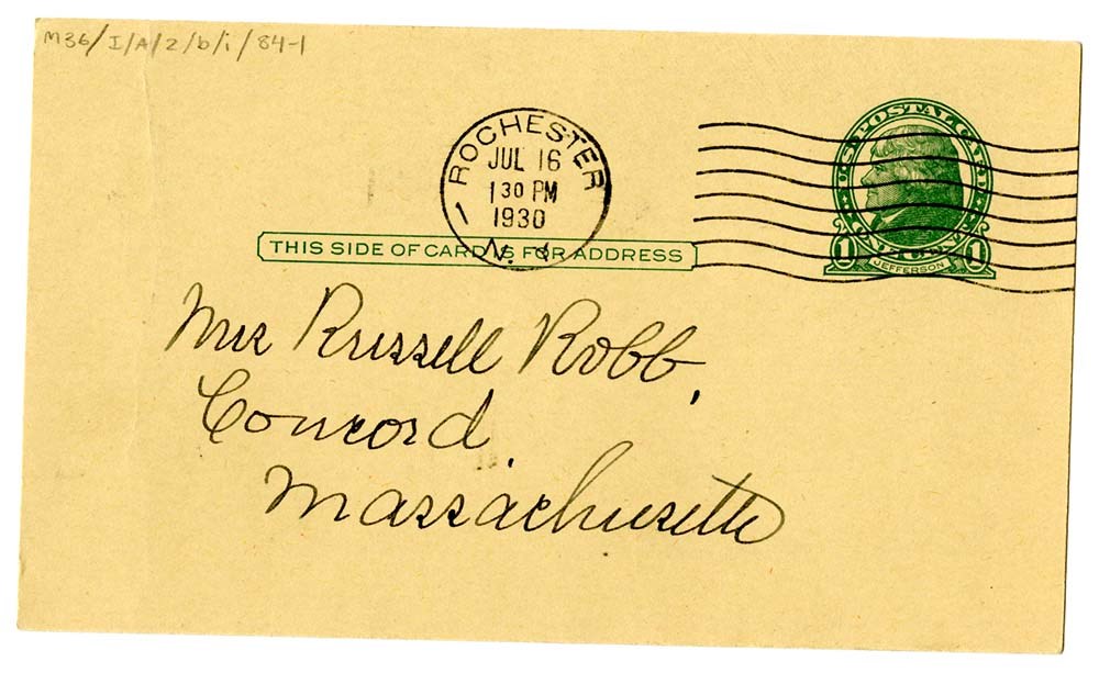
Letters to Mother [July 1930 - October 1930]
https://archives.whyte.org/en/permalink/descriptions7433
- Part Of
- Peter and Catharine Whyte fonds
- Scope & Content
- File pertains to 47 letters and postcards written by Catharine Robb Whyte to her mother, Edith Morse Robb from July 1930 to October 1930. Topics include the trip back to Banff after marriage, day to day life, meeting and visiting Pete's friends, the Banff community and artists [including Bill Brews…
- Date Range
- 1930
- Reference Code
- M36 / I / A / 2b / i / 84
- Description Level
- 5 / File
- GMD
- Private record
1 image
1 Electronic Resource
- Part Of
- Peter and Catharine Whyte fonds
- Description Level
- 5 / File
- Fonds Number
- M36 / V683 / S37
- Series
- I.A.2. Catharine Robb Whyte papers / photographs
- Sous-Fonds
- M36
- Accession Number
- .
- Reference Code
- M36 / I / A / 2b / i / 84
- GMD
- Private record
- Date Range
- 1930
- Physical Description
- 1.3 cm of textual records (82 pages ; 21.4 x 27.5 cm or smaller)
- History / Biographical
- See fonds level description.
- Scope & Content
- File pertains to 47 letters and postcards written by Catharine Robb Whyte to her mother, Edith Morse Robb from July 1930 to October 1930. Topics include the trip back to Banff after marriage, day to day life, meeting and visiting Pete's friends, the Banff community and artists [including Bill Brewster, Jim Brewster, Guy Davenport, Sid Graves, Sid Brewster, Mary Vaux Walcott, Jimmy Simpson, Byron Harmon, Fern Brewster, Wayne Palmer, Fred McCauley, Mrs. Brett, Julia Raymond, Pearl Moore, Edmee Moore, Philip Moore, J.E.H. MacDonald, Mr. and Mrs. Link, Mr. and Mrs. Painter, George Brewster, Jessie McLean, Buddy van Dyke, Dorothy Whyte, John Murray Gibbon, Carl Rungius, Fred Arbrister, Neil Begg, Rudolph Aemner,] painting outdoors, people in Concord, meeting Noel Odell of the 1924 Everest Expedition, a fire at a tea house in town, plans for building their home [including a sketch of the lots along Bow River], visiting Castle Mountain Camp and Kicking Horse Tea House, description of Skoki Lodge building plans [with Cliff White, Cyril Paris, and Ike Mills], and builders Earl Spencer and Spud White, and painting in Morley [Mrs. Twoyoungmen, John Simian or Black Buffalo, Jonas Richson [?], Dan Wildman and other illegible names], the climb to Abbot Pass, Lake Oesa, and Lake O'Hara Camp.
- Notes
- Please note: language pertaining to Indigenous Peoples, people of colour, and those of the Jewish faith used throughout is outdated and offensive. Some items were stapled together and therefore scanned together as one document. Letters are all handwritten and include some hotel and camp letterheads. Some letters are marked with a small x in pencil, indicating where Jon Whyte made notes for use in his project "Catharine Robb Whyte, Peter Whyte: Commemorative Portfolio," originally published in 1981. Some letters also have numbers written in pencil crayon, believed to be from when originally processed.
- Name Access
- Brewster, Bill
- Brewster, Fern
- Brewster, Jim
- Brewster, George
- Davenport, Guy
- Gibbon, John Murray
- Harmon, Byron
- Graves, Syd Brewster
- Paris, Cyril
- Mills, Ike
- Rungius, Carl
- Spencer, Earl
- Link, Adeline
- Link, George K.K.
- MacDonald, J. E. H.
- Browne, Belmore
- Mather, Allan
- Wildman, Dan, Sr.
- Curren, John Donaldson
- Whyte, Catharine
- Whyte, Peter
- White, Clifford
- Aemmer, Rudolf
- Alpine Club of Canada
- Armbrister, Fred
- Subject Access
- Activities
- Animals
- Art
- Artists
- Banff
- Bow River
- Camps
- Castle Mountain
- Climbing
- Community events
- Community life
- Family
- Family and personal life
- First Nations
- Hiking
- Home
- Indigenous Peoples
- Japanese
- Lake Louise
- Lake O'Hara Bungalow Camp
- Lake O'Hara region
- Log structures
- Moore House
- Mountains
- Pack trips
- Painting
- Paris Tea Room
- Personal and Family Life
- Property
- Skoki Lodge
- Stoney
- Stoney Nakoda
- Summit
- Yoho Valley Bungalow Camp
- Geographic Access
- Abbot Pass
- Alberta
- Banff
- Canadian Rocky Mountains
- Castle Mountain
- Concord
- Lake Louise
- Yoho National Park
- Field
- Lake O'Hara
- Skoki
- Morley
- Language
- English
- Creator
- Robb Whyte, Catharine
- Title Source
- Title based on contents of file
- Processing Status
- Processed
Electronic Resources

Images
This material is presented as originally created; it may contain outdated cultural descriptions and
potentially offensive content.
Read more.
- Part Of
- Murray Hay fonds
- Scope & Content
- File consists of 2 prints : col. ; 35 x 28 cm. File pertains to Murray Hay's rendering of Marmot Basin ski area in Jasper National Park. File includes two iterations of reproduction draft prints of Hay's map of Marmot Basin.
- Date Range
- ca.1976-ca.2000
- Reference Code
- V795 / II / B / i / 1
- Description Level
- 5 / File
- GMD
- Map
- Private record
- Part Of
- Murray Hay fonds
- Description Level
- 5 / File
- Fonds Number
- M570 / V795
- Series
- V795 / II : Unpublished Material
- Sous-Fonds
- V795
- Sub-Series
- V795 / II / B : Alberta / i : Jasper National Park
- Accession Number
- 2019.41
- Reference Code
- V795 / II / B / i / 1
- GMD
- Map
- Private record
- Date Range
- ca.1976-ca.2000
- Physical Description
- 2 prints : col. ; 35 x 28 cm
- Scope & Content
- File consists of 2 prints : col. ; 35 x 28 cm. File pertains to Murray Hay's rendering of Marmot Basin ski area in Jasper National Park. File includes two iterations of reproduction draft prints of Hay's map of Marmot Basin.
- Name Access
- Hay, Murray
- Subject Access
- Advertising
- Artist
- Ski Maps
- Ski area
- Map
- Cartography
- Sports and recreation
- Tourism
- Tourist information
- Winter
- Winter sports
- Geographic Access
- Jasper Marmot Basin
- Jasper National Park
- Alberta
- Canada
- Canadian Rocky Mountains
- Language
- English
- Related Material
- M570 / III / B / iii / 1
- Creator
- Hay, Murray
- Title Source
- Title based on contents of file
- Processing Status
- Processed
This material is presented as originally created; it may contain outdated cultural descriptions and
potentially offensive content.
Read more.
Newspaper Clippings
https://archives.whyte.org/en/permalink/descriptions54745
- Part Of
- Murray Hay fonds
- Scope & Content
- File consists of 1 cm of textual material in the form of newspaper clippings, 32 x 60 cm or smaller. File pertains to the career of Murray Hay as a ski map artist. File documents Hay's wide-ranging success creating trail maps for ski resorts, particularly in Alberta and British Columbia, Canada (al…
- Date Range
- 1991
- 1993
- 1996
- 1998
- Reference Code
- M570 / I / 1
- Description Level
- 5 / File
- GMD
- Published record
- Textual record
- Newspaper clipping
- Part Of
- Murray Hay fonds
- Description Level
- 5 / File
- Fonds Number
- M570 / V795
- Series
- M570 / I : Newspaper Clippings
- Sous-Fonds
- M570
- Accession Number
- 2019.41
- Reference Code
- M570 / I / 1
- Date Range
- 1991
- 1993
- 1996
- 1998
- Physical Description
- 1 cm of textual records (32 x 60 cm or smaller)
- Scope & Content
- File consists of 1 cm of textual material in the form of newspaper clippings, 32 x 60 cm or smaller. File pertains to the career of Murray Hay as a ski map artist. File documents Hay's wide-ranging success creating trail maps for ski resorts, particularly in Alberta and British Columbia, Canada (although he made maps for ski resorts and other organizations internationally, particularly in the United States). File also includes interviews with Hay about his mapmaking process and style, successes, challenges (including the impact of technology on his work).
- 2020-02-14
- Notes
- Includes articles that were published in the Calgary Sun (January 17, 1991) and the Calgary Herald (March 11, 1993; March 2, 1996; April 16, 1998).
- Name Access
- Hay, Murray
- Subject Access
- Ski areas
- Skiing
- Sports and recreation
- Art
- Artist
- Map
- Ski Maps
- Activities
- Banff National Park
- Cartography
- Lake Louise Ski Area
- Landscapes
- Professional and Personal Life
- Winter
- Winter sports
- Whistler Blackcomb
- Newspaper
- Calgary Herald
- Calgary Sun
- Geographic Access
- Canada
- Canadian Rocky Mountains
- Alberta
- Banff National Park
- Jasper National Park
- British Columbia
- Calgary
- Language
- English
- Title Source
- Title based on contents of file
- Processing Status
- Processed
This material is presented as originally created; it may contain outdated cultural descriptions and
potentially offensive content.
Read more.
Sunshine Ski Area
https://archives.whyte.org/en/permalink/descriptions54780
- Part Of
- Murray Hay fonds
- Scope & Content
- File consists of 1.5 cm of textual records, 58 x 72.5 cm and 21.5 x 27.5 cm. File pertains to ski trail maps of Sunshine Ski Area created by Murray Hay. File includes two published reproductions of original trail maps in poster format made by Hay for the Husky World Downhill and Giant Slalom on Mar…
- Date Range
- ca.1985-1986
- 1986
- Reference Code
- M570 / III / B / i / 1-2
- Description Level
- 5 / File
- GMD
- Map
- Poster
- Textual record
- Published record
- Part Of
- Murray Hay fonds
- Description Level
- 5 / File
- Fonds Number
- M570 / V795
- Series
- M570 / III : Murray Hay Portfolio (published material)
- Sous-Fonds
- M570
- Sub-Series
- M570 / III / B : Alberta / i : Sunshine
- Accession Number
- 2019.41
- Reference Code
- M570 / III / B / i / 1-2
- Date Range
- ca.1985-1986
- 1986
- Physical Description
- 1.5 cm of textual records (58 x 72.5 cm and 21.5 x 27.5 cm)
- Scope & Content
- File consists of 1.5 cm of textual records, 58 x 72.5 cm and 21.5 x 27.5 cm. File pertains to ski trail maps of Sunshine Ski Area created by Murray Hay. File includes two published reproductions of original trail maps in poster format made by Hay for the Husky World Downhill and Giant Slalom on March 8-9, 1986.
- Notes
- M570 / III / B / i / 2 is oversize.
- Name Access
- Hay, Murray
- Subject Access
- Skiing
- Ski Maps
- Ski area
- Tourism
- Cartography
- Map
- Winter
- Winter sports
- Travel
- Sunshine Village
- Sunshine Ski Resort
- Sunshine area
- Sports and recreation
- Artist
- Advertising
- Geographic Access
- Banff National Park
- Alberta
- Canada
- Canadian Rocky Mountains
- Language
- English
- Related Material
- V795 / II / B / vi / 1-3
- Title Source
- Title based on contents of file
- Processing Status
- Processed
This material is presented as originally created; it may contain outdated cultural descriptions and
potentially offensive content.
Read more.
Sunshine Village
https://archives.whyte.org/en/permalink/descriptions54991
- Part Of
- Murray Hay fonds
- Scope & Content
- File consists of 9 prints : b&w and col. ; 35 x 28 cm or smaller, 2 maps (1 base, 4 overlays) : col., annotations, on mylar ; 26 x 35 cm and 23.5 x 31.5 cm, and 1 painting : landscape ; 46 x 43 cm. File pertains to ski trail maps and landscape maps/prints of Sunshine ski area created by Murray Hay.…
- Date Range
- ca.1980-ca.1999
- Reference Code
- V795 / II / B / vi / 1-3
- Description Level
- 5 / File
- GMD
- Map
- Painting
- Private record
- Part Of
- Murray Hay fonds
- Description Level
- 5 / File
- Fonds Number
- M570 / V795
- Series
- V795 / II : Unpublished Material
- Sous-Fonds
- V795
- Sub-Series
- V795 / II / B : Alberta / vi : Sunshine Village Ski Resort
- Accession Number
- 2019.41
- Reference Code
- V795 / II / B / vi / 1-3
- Date Range
- ca.1980-ca.1999
- Physical Description
- 9 prints : b&w and col. ; 35 x 28 cm or smaller
- 2 maps (1 base, 4 overlays) : col., annotations, on mylar ; 26 x 35 cm and 23.5 x 31.5 cm
- 1 painting : landscape ; 46 x 43 cm
- Scope & Content
- File consists of 9 prints : b&w and col. ; 35 x 28 cm or smaller, 2 maps (1 base, 4 overlays) : col., annotations, on mylar ; 26 x 35 cm and 23.5 x 31.5 cm, and 1 painting : landscape ; 46 x 43 cm. File pertains to ski trail maps and landscape maps/prints of Sunshine ski area created by Murray Hay. File includes 9 reproduced draft prints (various iterations), 2 reproduced maps with overlays held together with masking tape, and 1 original painting/drawing (unfinished).
- Name Access
- Hay, Murray
- Subject Access
- Advertising
- Artist
- Ski Maps
- Ski area
- Map
- Cartography
- Sports and recreation
- Tourism
- Tourist information
- Winter
- Winter sports
- Sunshine area
- Sunshine Village
- Sunshine Ski Resort
- Geographic Access
- Sunshine
- Alberta
- Canada
- Canadian Rocky Mountains
- Banff National Park
- Language
- English
- Related Material
- M570 / III / B / i / 1-2
- Creator
- Hay, Murray
- Title Source
- Title based on contents of file
- Processing Status
- Processed
This material is presented as originally created; it may contain outdated cultural descriptions and
potentially offensive content.
Read more.
Yoho National Park
https://archives.whyte.org/en/permalink/descriptions54863
- Part Of
- Murray Hay fonds
- Scope & Content
- File consists of 19 colour photographs, 15 x 10 cm or smaller (some are pasted on to a piece of paper, 21.5 x 28 cm). File pertains to projects Murray Hay worked on related to Yoho National Park, specifically Emerald Lake and Lake O'Hara. Photographs depict original paintings created by Hay.
- Date Range
- ca.1980-ca.2000
- Reference Code
- V795 / II / A / i / 1
- Description Level
- 5 / File
- GMD
- Photograph print
- Photograph
- Private record
- Part Of
- Murray Hay fonds
- Description Level
- 5 / File
- Fonds Number
- M570 / V795
- Series
- V795 / II : Unpublished Material
- Sous-Fonds
- V795
- Sub-Series
- V795 / II / A : British Columbia / i : Yoho National Park
- Accession Number
- 2019.41
- Reference Code
- V795 / II / A / i / 1
- Date Range
- ca.1980-ca.2000
- Physical Description
- 19 photographs : col. ; 15 x 10 cm or smaller
- Scope & Content
- File consists of 19 colour photographs, 15 x 10 cm or smaller (some are pasted on to a piece of paper, 21.5 x 28 cm). File pertains to projects Murray Hay worked on related to Yoho National Park, specifically Emerald Lake and Lake O'Hara. Photographs depict original paintings created by Hay.
- Notes
- Many of the photographic prints are either taped together in a specific way or or taped to a separate sheet of paper and labelled accordingly. They remain filed this way as this demonstrates Hay's process of creating paintings and maps.
- Name Access
- Hay, Murray
- Subject Access
- Artist
- Art
- Cartography
- Landscapes
- Mountains
- Photography
- Professional and Personal Life
- Geographic Access
- Yoho National Park
- British Columbia
- Canada
- Canadian Rocky Mountains
- Emerald Lake
- Lake O'Hara
- Language
- English
- Conservation
- There is masking tape holding the phtoographs together, which should be removed and alternative preservation methods should be considered at a reasonable time to do so.
- Title Source
- Title based on contents of file
- Processing Status
- Processed
This material is presented as originally created; it may contain outdated cultural descriptions and
potentially offensive content.
Read more.