Narrow Results By
- Robert William Sinclair (1939 – , Canadian) 51
- Gadd, Ben 18
- Alexander Young Jackson (1882 – 1974, Canadian) 11
- Kathleen Frances Daly Pepper (1898 – 1994, Canadian) 9
- Alfred Crocker Leighton, R. C. A. (1901 – 1965, Canadian) 8
- Fitzpatrick 6
- Hay, Murray 5
- Herbert C. Hahn (1907 – , American) 5
- Scott, Chic 4
- John Davenall Turner (1900 – 1980, Canadian) 3
- R. L. Hunter 3
- Stewart, Maryalice Harvey 3
Dorothy Wardle fonds
https://archives.whyte.org/en/permalink/descriptions398
- Part Of
- Dorothy Wardle fonds
- Scope & Content
- Fonds consists of two sous-fonds: M521 and V75. M521 consists of four series, 154 cm, ca.1870-2002. Series I: Dorothy Wardle Personal Papers, 69.5 cm, ca.1870-2002 (includes Dorothy's written work and research and notes related to Banff). Series II: Wardle Family, 32.5 cm, 1872-1998 (including cor…
- Date Range
- ca.1870-2002
- Reference Code
- M521 / V75
- Description Level
- 1 / Fonds
- GMD
- Photograph
- Album
- Negative
- Photograph print
- Postcard
- Transparency
- Textual record
- Private record
- Published record
- Part Of
- Dorothy Wardle fonds
- Description Level
- 1 / Fonds
- Fonds Number
- M521
- V75
- Sous-Fonds
- M521
- V75
- Accession Number
- 5296, 5391, 7504
- Reference Code
- M521 / V75
- GMD
- Photograph
- Album
- Negative
- Photograph print
- Postcard
- Transparency
- Textual record
- Private record
- Published record
- Date Range
- ca.1870-2002
- Physical Description
- 154 cm of textual records. -- 1304 photographs (1190 prints, 95 negatives, 19 transparencies). -- 6 photograph albums.
- History / Biographical
- The Wardle family was comprised of husband and wife, James Morey Wardle (June 26,1888 - May 18,1971) and Maud Leette (Roney) Wardle (May 24,1889 - December 1,1969), and their one child, Dorothy Hope Wardle (May 23,1919 - July 20,2003). James Wardle, born in Chiliwack, British Columbia, was a civil engineer and public servant. He was the Superintendent of Banff National Park from 1918-1921, Chief Engineer for Parks Canada from 1921-1935, and Deputy Minister of the Interior from 1935-1936. He is primarily known as a highway design engineer, particularly for building the Banff-Windermere, Banff-Lake Louise, and Banff-Jasper highways. He was a councillor for the Municipality of Rockcliffe Park in Ontario and he was the President of the Trail Riders of the Canadian Rockies in Banff from 1925-1929. Mount Wardle in Vermillion was named after him in 1921. James married Leette on November 4, 1913, with whom he had one child, Dorothy. Born in Calgary, Alberta, Dorothy (also known as Dot and Dorie) grew up in Banff, Alberta and Ottawa, Ontario, due to her father's position with the federal government. She was educated at the Mountain School in Banff and at the Elmwood School in Ottawa. All three family members were graduates of Queen's University in Kingston, Ontario. James graduated in 1912 with a Bachelor of Science in Engineering, Leette graduated with a Bachelor's degree, and in 1942, Dorothy also earned a Bachelor's degree. Dorothy was prominent in student life and active in athletics. In 1941, Dorothy became the first woman elected as President of the Alma Mater Society and during her academic career, Dorothy was a member of the Levana Intercollegiate Debative, University Centenary Committee, and Queen’s War Aid Commission. Dorothy spent her career as a freelance writer however, upon graduation she served as the first Secretary-In-Charge of Records at Carleton College (now Carleton University) from 1942-1944 in Ottawa and in the mid-1950s worked as a secretary for the Glenbow Foundation in Calgary. Dorothy pursued a lifelong interest in traveling, art, and antiques. Although she was fiercely proud and protective of Banff and the Park, and remained a volunteer and patron of the Whyte Museum of the Canadian Rockies, Dorothy eventually settled in Sidney, British Columbia and shared an apartment with Sheila Iris Ritchie, with whom Dorothy travelled extensively. After her death in 2003, Dorothy, "Dorie," was laid to rest alongside her parents in the Old Banff Cemetery.
- Scope & Content
- Fonds consists of two sous-fonds: M521 and V75.
- M521 consists of four series, 154 cm, ca.1870-2002. Series I: Dorothy Wardle Personal Papers, 69.5 cm, ca.1870-2002 (includes Dorothy's written work and research and notes related to Banff). Series II: Wardle Family, 32.5 cm, 1872-1998 (including correspondence with Carl Rungius and Mrs. Helen Brett, and Christmas and other greeting cards from Peter and Catharine Whyte). Series III: Queen's University, 7.5 cm, 1911-1980 (including graduation certificates for each family member and records pertaining to Dorothy's participation on the Alma Mater Society). Series IV: Travel, 44.5 cm, ca.1950-1988 (includes hand-written notebooks meticulously detailing their travels).
- V75 consists of two series, 79.5 cm, ca. 1912-2001. Series I: Wardle Family, ca. 1912-1971, 6 albums, 31 cm of photograph prints and negatives (including family trips, trail rides in the Canadian Rocky Mountains, and family gatherings). Series II: Dorothy Wardle, 1972-2001, 34 cm of photograph prints, negatives, and transparencies (including Dorothy's travels in Alberta and British Columbia, overseas, and various outings with friends).
- Name Access
- Wardle, Dorothy
- Wardle, James
- Rungius, Carl
- Brett, Helen
- Keyte, Freeman
- Hart, E. J. (Ted)
- Harkin, J. B. (James Bernard)
- Brewster, Pat
- Peyto, Bill
- Brett, Robert George
- Sanson, Norman
- White, Clifford
- Drummond-Davies, Nora
- Mills, Ike
- McLean, George
- Walking Buffalo (George McLean)
- Kaquitts, Frank
- Oxborough, Dorothy
- Whyte, Jon
- Robinson, Dean
- Warren, Mary Schaffer
- Simpson, George
- Gibbon, John Murray
- Whyte, Catharine
- Whyte, Peter
- Greenham, Margaret
- Subject Access
- Arts
- Environment
- Personal and Family Life
- Banff
- Old Banff Cemetery
- Whyte Museum of the Canadian Rockies
- Cabins
- Travel
- Picnics and picnicking
- Holidays
- Scenery
- Christmas
- Dogs
- Horses
- Mountain
- Canoes and canoeing
- Hiking
- Wildlife
- War Memorial
- Highland Games
- Bow River Bridge
- Golfing
- Anniversary
- Horseback riding
- Indigenous Peoples
- Stoney Nakoda
- Education
- Snowshoes and snowshoeing
- Banff Winter Carnival
- Banff Winter Festival
- Women
- Trails
- Trail Riders of the Canadian Rockies
- Sports and leisure
- Skiing
- European travel
- Beach
- Calgary Herald
- Geography
- Government
- Newspaper
- Politics
- Research
- Banff Public Library
- National parks and reserves
- Park policy
- Parks Canada
- Wardens
- Ya-Ha-Tinda Ranch
- Community life
- Mines and mineral resources
- History
- Immigration and homesteading
- Settlement
- Organizations
- World War II
- Biographical
- Professional and Personal Life
- Grizzly Bears
- Fire fighters
- Sunshine Village
- Teahouses
- Banff Indian Days
- Regalia
- Calgary Stampede
- Mountain guides
- Mountain School
- The Albertan
- Crag and Canyon newspaper
- Homestead Hotel
- Banff Centre
- Hot Springs
- Superintendents
- Automobiles
- Natural history
- Records
- Calendar
- Finances
- Leases
- Legal and Financial
- Property
- Recreation
- Geographic Access
- Banff
- Banff National Park
- Canmore
- Alberta
- Canada
- Canadian Rocky Mountains
- Castle Mountain
- Bankhead
- British Columbia
- Glacier National Park
- Kootenay National Park
- Silver City
- Victoria
- Scotland
- Revelstoke
- Yoho National Park
- Ottawa
- Ontario
- Prince Edward Island
- Plain of Six Glaciers
- Lake Agnes
- Lake Louise
- Lake Minnewanka
- Lake O'Hara
- Bow River
- Calgary
- Sidney
- San Francisco
- United States
- Europe
- Germany
- Switzerland
- France
- Spain
- Monaco
- Italy
- Denmark
- Austria
- Quebec
- Windermere
- New York
- Assiniboine
- Ghost River
- High River
- Quebec City
- New Brunswick
- Maine
- Great Divide
- Moraine Lake
- Maligne Lake
- Columbia Icefield
- Washington
- Philadelphia
- Atlantic City
- Larch Valley
- Cascade Mountain
- Panama
- Sulphur Mountain
- Field
- Emerald Lake
- Head Smashed In Buffalo Jump
- Takkakaw Falls
- Jasper National Park
- Athabasca Falls
- Okanagan
- Kananaskis
- Hoodoos
- Powell River
- Montreal
- Access Restrictions
- Some restriction/s on access
- Copyright, privacy, commercial use and other restrictions may apply
- Language
- Language is English
- Related Material
- Dorothy also donated artwork (by Carl Rungius) to Art and Heritage.
- James Morey Wardle fonds (Library and Archives Canada)
- Category
- Arts
- Environment
- Education
- Exploration, discovery and travel
- Family and personal life
- First nations
- Sports, recreation and leisure
- Title Source
- Title based on accession records and contents of fonds
- Processing Status
- Processed
This material is presented as originally created; it may contain outdated cultural descriptions and
potentially offensive content.
Read more.
Margaret Oliver fonds
https://archives.whyte.org/en/permalink/descriptions55186
- Part Of
- Margaret Oliver fonds
- Scope & Content
- Fonds consists of transparency slides, maps, handwritten notes and club records, song books, and scrapbooks pertaining to Margaret Ruth Oliver and the Tuesday Hikers club.
- Date Range
- 1971-2010
- Reference Code
- M569 / V793
- Description Level
- 1 / Fonds
- GMD
- Textual record
- Photograph
- Transparency
- Published record
- Private record
- Scrapbook
- Map
- Organization record
- Part Of
- Margaret Oliver fonds
- Description Level
- 1 / Fonds
- Fonds Number
- M569 / V793
- Sous-Fonds
- M569
- V793
- Accession Number
- 2017.8656
- Reference Code
- M569 / V793
- GMD
- Textual record
- Photograph
- Transparency
- Published record
- Private record
- Scrapbook
- Map
- Organization record
- Date Range
- 1971-2010
- Physical Description
- 28 photographs : col. slides -- 1.5 m of textual records (3 binders -- 1 record book -- 10 song books -- maps, annotated -- 11 scrapbooks)
- History / Biographical
- Margaret Ruth Oliver was born on December 19, 1927 to parents Edgar and Gladys (Brazier) Hammett in Winnipeg, Manitoba. Margaret's siblings include Dorothy (1922), Muriel "Miv" (1923), John (1929), and Jean (1933). Margaret graduated from United College (Winnipeg) in 1949 with a B.Sc. degree, and worked as an Assistant Librarian at the University of Manitoba afterwards. Margaret later enrolled in a Laboratory Technician program at the University of Manitoba Medical College. Margaret married Thomas Albert Oliver, a fellow University of Manitoba alumnus, on September 25, 1954. The couple moved to Calgary for work (Thomas taught at the University of Calgary, and Margaret worked for a geophysical company). Margaret travelled extensively following the death of her husband in 1997, visiting places such as Nepal, Cambodia, Russia, Egypt and Greenland. In 1971, Margaret formed a hiking group within the University Faculty Women's Club (F.W.C.) through the University of Calgary. In 1976, this group became a private club called the Tuesday Hikers, which no longer held any affiliation to the F.W.C. Trips included weekly hikes and/or ski trips, as well as longer backpacking excursions.The club is still active as of 2022.
- Scope & Content
- Fonds consists of transparency slides, maps, handwritten notes and club records, song books, and scrapbooks pertaining to Margaret Ruth Oliver and the Tuesday Hikers club.
- Notes
- Materials are unprocessed and stored in three boxes: Box 1: 1 envelope "T. Hikers' Slides" - 28 film transparencies and printed notes; various maps with handwritten notes Box 2: 1 record book "T.H. Record Book" - handwritten lists and statistics of trips, attendance, miles; 2 binders with handwritten notes, titled "National Parks - Banff and Assiniboine" and "Nat'l Parks - Glacier + Jasper" Box 3: 1 binder titled "Tues. Hikers- Past Members and Guests"; 10 song books; trail, park and road maps; 11 scrapbooks, 1971-2010
- Name Access
- Oliver, Margaret
- Subject Access
- Hiking
- Travel
- Recreation
- Club
- Map
- Trails
- Music
- Entertainment
- Geography
- Geographic Access
- Canada
- Alberta
- Banff National Park
- Jasper National Park
- Assiniboine
- British Columbia
- Glacier National Park
- Language
- English
- Biographical Source Notes
- https://biblio.uottawa.ca/en/node/16056
- Title Source
- Title based on content in fonds
- Processing Status
- Unprocessed
This material is presented as originally created; it may contain outdated cultural descriptions and
potentially offensive content.
Read more.
- Part Of
- Murray Hay fonds
- Scope & Content
- File consists of 144 photographs : col. negatives ; 35 m m; 12 prints : col. ; 42 x 35 cm or smaller ; 1 cm of visual material. File pertains to various projects Murray Hay was involved with related to Alaska, USA, particularly in the mid-1990s. File includes: aerial photographs of the landscape (A…
- Date Range
- ca.1990-ca.1999
- 1992
- 1994
- Reference Code
- V795 / II / D / i / 1-2
- Description Level
- 5 / File
- GMD
- Drawing
- Map
- Photograph print
- Negative
- Private record
- Textual record
- Part Of
- Murray Hay fonds
- Description Level
- 5 / File
- Fonds Number
- M570 / V795
- Series
- V795 / II : Unpublished Material
- Sous-Fonds
- V795
- Sub-Series
- V795 / II / D : International / i : United States of America
- Accession Number
- 2019.41
- Reference Code
- V795 / II / D / i / 1-2
- Date Range
- ca.1990-ca.1999
- 1992
- 1994
- Physical Description
- 144 photographs : col. negatives ; 35 mm
- 12 prints : col. ; 42 x 35 cm or smaller
- 1 cm of visual material
- Scope & Content
- File consists of 144 photographs : col. negatives ; 35 m m; 12 prints : col. ; 42 x 35 cm or smaller ; 1 cm of visual material. File pertains to various projects Murray Hay was involved with related to Alaska, USA, particularly in the mid-1990s. File includes: aerial photographs of the landscape (Anchorage area, Homer, Prince William Sound, Valdez); hand-drawn draft maps of the Prince William Sound region (created for a cruise line); a variety of printed maps with annotations demonstrating comments (including a fax with an attached map from Dana at Adventure Media International); and a variety of printed reproductions of draft maps (Alyeska Ski Resort, City of Anchorage for the 1992 Olympic Bid, and Glacier Bay and the Tongass National Forest).
- Notes
- Items not in oversize (negatives) stored in downstairs vault.
- Name Access
- Hay, Murray
- Subject Access
- Advertising
- Artist
- Ski Maps
- Map
- Cartography
- Sports and recreation
- Tourism
- Tourist information
- Travel
- Geography
- Winter
- Winter sports
- Ski area
- Olympic Games (Winter)
- Geographic Access
- Alaska
- United States
- Valdez
- Prince William Sound
- Anchorage
- Glacier Bay and Tongass National Forest
- Language
- English
- Conservation
- Masking tape should be removed and alternative preservation methods used in the future.
- Related Material
- M570 / IV / A / 2-3
- Creator
- Hay, Murray
- Title Source
- Title based on contents of file
- Processing Status
- Processed
This material is presented as originally created; it may contain outdated cultural descriptions and
potentially offensive content.
Read more.
Antique Maps of India and Germany, Walter Wilcox Mounts
https://archives.whyte.org/en/permalink/descriptions54204
- Part Of
- Nicholas Morant fonds
- Scope & Content
- File consists of 13 antique maps, 6 of which depict regions in India and 7 which depict regions in Germany. Content pertains to a small map collection originally issued to Tim Ffrench (?) during WWII which were later owned by Nicholas Morant. Some maps of reserves contain personal annotations and h…
- Date Range
- 1868
- 1892
- 1894
- 1903
- 1904
- 1917
- 1921
- 1950
- Reference Code
- M300 / III / D / 5 / 54 to 66 O.S. & V500 / III / D / 5 / PA - 96 O.S.
- Description Level
- 5 / File
- GMD
- Map
- Textual record
- Part Of
- Nicholas Morant fonds
- Description Level
- 5 / File
- Fonds Number
- V500
- Sous-Fonds
- V500
- Sub-Series
- M300 & V500 / III / D / 5 : Personal Interest and Gifts
- Accession Number
- 7784
- Reference Code
- M300 / III / D / 5 / 54 to 66 O.S. & V500 / III / D / 5 / PA - 96 O.S.
- GMD
- Map
- Textual record
- Other Title Info
- Parallel title is original title
- Responsibility
- Nicholas Morant
- Date Range
- 1868
- 1892
- 1894
- 1903
- 1904
- 1917
- 1921
- 1950
- Physical Description
- 13 Maps: print; b&w, and set of 4 rag paper mounts
- Scope & Content
- File consists of 13 antique maps, 6 of which depict regions in India and 7 which depict regions in Germany. Content pertains to a small map collection originally issued to Tim Ffrench (?) during WWII which were later owned by Nicholas Morant. Some maps of reserves contain personal annotations and highlighted/coloured routes; none of German maps are annotated. File also contains set of 4 rag paper mounts, annotated. 3 naming artist Walter Wilcox (likely formerly held his works but are now blank). One labelled 'Model'.
- Notes
- Maps were originally stored together in one poster tube labelled: "MAPS OF GERMANY INDIA See notes inside" Shipping label: PLS HOLD Armand To Nicholas Morant 222 Melville Ave Westmount Montreal" (with two 3 - cent stamps attached) Note inside, written by Nicholas Morant: "These maps were among those issued to Capt. Tim Ffrench (?) preparatory to intelligence work done during W. War II" Signed "Nick M." Wilcox mounts were stored in brown paper packaging with several other blank mounts (disposed of). Labelled section of original paper packaging has been stored with mounts in oversize box for reference.
- Geographic Access
- Germany
- India
- Access Restrictions
- Items in this file are not to be accessed or distributed without the explicit permission of their identified owners
- Reproduction Restrictions
- Items in this file are not to be reproduced without the explicit permission of their identified owners.
- Language
- English
- German
- Conservation
- Items must be kept only with items of similar materials, and stored with protective acid-free barriers to prevent further damage.
- Title Source
- Title based on contents of file
- Processing Status
- Processed
This material is presented as originally created; it may contain outdated cultural descriptions and
potentially offensive content.
Read more.
- Part Of
- Murray Hay fonds
- Scope & Content
- File consists of 1 map : col., annotations, 96.5 x 69 cm. File pertains to an original unfinished hand-drawn map of interior Arizona in red, blue, black, and purple ink. Includes geographic features and labeled cities (including Yuma, Nogales, Bisbee, and Flagstaff).
- Date Range
- ca.1990-ca.1999
- Reference Code
- V795 / II / D / i / 4
- Description Level
- 5 / File
- GMD
- Drawing
- Map
- Private record
- Textual record
- Part Of
- Murray Hay fonds
- Description Level
- 5 / File
- Fonds Number
- M570 / V795
- Series
- V795 / II : Unpublished Material
- Sous-Fonds
- V795
- Sub-Series
- V795 / II / D : International / i : United States of America
- Accession Number
- 2019.41
- Reference Code
- V795 / II / D / i / 4
- Date Range
- ca.1990-ca.1999
- Physical Description
- 1 map : col., annotations ; 96.5 x 69 cm
- Scope & Content
- File consists of 1 map : col., annotations, 96.5 x 69 cm. File pertains to an original unfinished hand-drawn map of interior Arizona in red, blue, black, and purple ink. Includes geographic features and labeled cities (including Yuma, Nogales, Bisbee, and Flagstaff).
- Name Access
- Hay, Murray
- Subject Access
- Advertising
- Artist
- Ski Maps
- Map
- Cartography
- Sports and recreation
- Tourism
- Tourist information
- Travel
- Geography
- Winter
- Winter sports
- Ski area
- Geographic Access
- Arizona
- United States
- Language
- English
- Creator
- Hay, Murray
- Title Source
- Title based on contents of file
- Processing Status
- Processed
This material is presented as originally created; it may contain outdated cultural descriptions and
potentially offensive content.
Read more.
Author's copy of Geology Road Tours
https://archives.whyte.org/en/permalink/descriptions56293
- Part Of
- Ben Gadd fonds
- Scope & Content
- File consists of one author's copy of Ben Gadd's book, Geology Road Tours, which includes corrections and other annotations by the author.
- Date Range
- 2008
- Reference Code
- M590 / II / B / 59
- Description Level
- 5 / File
- GMD
- Textual record
- Published record
- Part Of
- Ben Gadd fonds
- Description Level
- 5 / File
- Fonds Number
- M590
- V810
- S61
- Series
- M590 / II : Research and publication records
- Sous-Fonds
- M590
- Sub-Series
- M590 / II / B : Other publications
- Accession Number
- 2021.20
- Reference Code
- M590 / II / B / 59
- Responsibility
- Produced by Ben Gadd, Corax Press
- Date Range
- 2008
- Physical Description
- 3.5 cm of textual records : 1 volume ; 15.5 x 23 cm
- Scope & Content
- File consists of one author's copy of Ben Gadd's book, Geology Road Tours, which includes corrections and other annotations by the author.
- Name Access
- Gadd, Ben
- Subject Access
- Publication
- Commercial products
- Environment
- Geology
- Science and technology
- Geography
- Natural history
- Travel
- Roads
- Map
- Geographic Access
- Canada
- Alberta
- British Columbia
- Canadian Rocky Mountains
- Reproduction Restrictions
- Copyright restrictions may apply
- Language
- English
- Title Source
- Title based on contents of file
- Processing Status
- Processed
This material is presented as originally created; it may contain outdated cultural descriptions and
potentially offensive content.
Read more.
Baja California Sur, Mexico
https://archives.whyte.org/en/permalink/descriptions54974
- Part Of
- Murray Hay fonds
- Scope & Content
- File consists of 11 maps : mss. and reproductions, some col., annotations ; 43 x 94 cm or smaller. File pertains to a project Murray Hay worked on for Glacier Bay Tours and Cruises (based out of Alaska). File includes 11 original hand-drawn and reproduced drafts, including annotations, of a map dep…
- Date Range
- ca.1990-ca.1999
- ca. 1998
- Reference Code
- V795 / II / D / ii / 2-3
- Description Level
- 5 / File
- GMD
- Drawing
- Map
- Private record
- Part Of
- Murray Hay fonds
- Description Level
- 5 / File
- Fonds Number
- M570 / V795
- Series
- V795 / II : Unpublished Material
- Sous-Fonds
- V795
- Sub-Series
- V795 / II / D : International / ii : Miscellaneous
- Accession Number
- 2019.41
- Reference Code
- V795 / II / D / ii / 2-3
- GMD
- Drawing
- Map
- Private record
- Date Range
- ca.1990-ca.1999
- ca. 1998
- Physical Description
- 11 maps : mss. and reproductions, some col., annotations ; 43 x 94 cm or smaller
- Scope & Content
- File consists of 11 maps : mss. and reproductions, some col., annotations ; 43 x 94 cm or smaller. File pertains to a project Murray Hay worked on for Glacier Bay Tours and Cruises (based out of Alaska). File includes 11 original hand-drawn and reproduced drafts, including annotations, of a map depicting the Baja California Sur region and the cruise's route in this area.
- Notes
- Originally filed with correspondence related to this project [see related material]. "For Steve Cowart" is also written on at least one map (who Murray Hay is corresponding with in M570 / IV / A / 1). Items not in oversize stored in downstairs vault.
- Name Access
- Hay, Murray
- Cowart, Steve
- Subject Access
- Advertising
- Artist
- Cartography
- Map
- Tourism
- Tourist information
- Travel
- Geography
- Geographic Access
- Mexico
- Baja California Sur
- Language
- English
- Related Material
- M570 / IV / A /1
- Creator
- Hay, Murray
- Title Source
- Title based on contents of file
- Processing Status
- Processed
This material is presented as originally created; it may contain outdated cultural descriptions and
potentially offensive content.
Read more.
Banff National Park and Lake Louise maps
https://archives.whyte.org/en/permalink/descriptions54945
- Scope & Content
- File consists of two folded maps and a small clipping [possibly top or bottom portion from a different map or one of maps in file]. One map is of Banff National Park and one is of Lake Louise [1959]. Banff National Park map has black pencil tracings over trail section near the bottom of the map and…
- Date Range
- 1959
- [1960-1970]
- Reference Code
- M545 / V / 53
- Description Level
- 5 / File
- GMD
- Textual record
- Published record
- Map
- Description Level
- 5 / File
- Fonds Number
- M545 / V635
- Series
- M545 / V : Administrative records
- Sous-Fonds
- M545
- Accession Number
- 8235
- Reference Code
- M545 / V / 53
- Date Range
- 1959
- [1960-1970]
- Physical Description
- 0.5 cm of textual records (2 maps ; 60.5 x 57.5 and 60 x 56.5 cm)
- Scope & Content
- File consists of two folded maps and a small clipping [possibly top or bottom portion from a different map or one of maps in file]. One map is of Banff National Park and one is of Lake Louise [1959]. Banff National Park map has black pencil tracings over trail section near the bottom of the map and annotation in bottom right corner which reads "Natural Bridge". Lake Louise map produced by the Government of Canada.
- Subject Access
- Banff National Park
- Environment
- Geography
- Map
- Lake Louise
- Travel
- Government
- National parks and reserves
- Trails
- Geographic Access
- Canada
- Alberta
- Banff National Park
- Lake Louise
- Language
- English
- Conservation
- Clipping stored in mylar due to significant staining and residue from tape
- Items kept folded [not placed in mylar] due to mass production of content and minimal/no annotations
- Title Source
- Title based on contents of file
- Processing Status
- Processed
This material is presented as originally created; it may contain outdated cultural descriptions and
potentially offensive content.
Read more.
Banff Springs Hotel, Alberta, Canada
https://archives.whyte.org/en/permalink/artifactgoe.03.01
- Date
- n.d.
- Medium
- graphite on paper
- Catalogue Number
- GoE.03.01
- Description
- General colour: black on white. Central image is a large stone building surrounded by large trees. Mountain-sides riseup behind and to the left. There is a golf flag on the lawn in the lower right corner.
- Title
- Banff Springs Hotel, Alberta, Canada
- Date
- n.d.
- Medium
- graphite on paper
- Dimensions
- 12.0 x 19.4 cm
- Description
- General colour: black on white. Central image is a large stone building surrounded by large trees. Mountain-sides riseup behind and to the left. There is a golf flag on the lawn in the lower right corner.
- Subject
- architecture
- landscape
- Credit
- Gift of Forrest (Pat) Oliver Brewster, Banff, 1967
- Catalogue Number
- GoE.03.01
This material is presented as originally created; it may contain outdated cultural descriptions and
potentially offensive content.
Read more.
Blueprints of Connaught Tunnel and Map of Deutchman Cave
https://archives.whyte.org/en/permalink/descriptions54207
- Part Of
- Nicholas Morant fonds
- Scope & Content
- File consists of 2 printed paper copies of older hand-illustrated works. Pertains to a copied 1947 blueprint of Connaught Tunnel depicting burn damage on tracks from an accident that year; and a copied hand-drawn map of Deutchman Cave from 1902, with annotations bottom right (copied from the origin…
- Date Range
- [ca. 1950 - ca. 1970]
- Reference Code
- V500 / III / D / 5 / PA - 73 to 74 O.S.
- Description Level
- 5 / File
- GMD
- Drawing
- Map
- Blueprint
- Part Of
- Nicholas Morant fonds
- Description Level
- 5 / File
- Fonds Number
- M300 / S20 / V500
- Sous-Fonds
- V500
- Sub-Series
- V500 / III / D / 5 : Personal Interest and Gifts
- Accession Number
- 7784
- Reference Code
- V500 / III / D / 5 / PA - 73 to 74 O.S.
- Responsibility
- Nicholas Morant
- Date Range
- [ca. 1950 - ca. 1970]
- Physical Description
- 2 paper copies: 1 blueprint, 1 map
- Scope & Content
- File consists of 2 printed paper copies of older hand-illustrated works. Pertains to a copied 1947 blueprint of Connaught Tunnel depicting burn damage on tracks from an accident that year; and a copied hand-drawn map of Deutchman Cave from 1902, with annotations bottom right (copied from the original).
- Notes
- Items were stored together in a poster tube labelled: "Canadian Pacific Blueprints - CPR Passenger Train in Connaught Tunnel - Nakimu Caves at Glacier"
- Subject Access
- Geography
- Connaught Tunnel
- Canadian Pacific Railway
- Train
- Transportation
- Geographic Access
- Canada
- British Columbia
- Canadian Rocky Mountains
- Access Restrictions
- Items in this file are not to be accessed or distributed without the explicit permission of their identified copyright owners.
- Reproduction Restrictions
- Items in this file are not to be reproduced without the explicit permission of their identified copyright owners.
- Language
- English
- Conservation
- Items must be stored flat with similar materials
- Creator
- Nicholas Morant
- Title Source
- Title based on contents of file
- Processing Status
- Processed
This material is presented as originally created; it may contain outdated cultural descriptions and
potentially offensive content.
Read more.
Book report notebook
https://archives.whyte.org/en/permalink/descriptions55658
- Part Of
- Maryalice Harvey Stewart fonds
- Scope & Content
- File consists of one spiral notebook titled "Part I - Book Report", dated 1965, with annotations by Maryalice Harvey Stewart. Content includes research notes pertaining to various historic people from the Banff area, a rough sketch of Castle Peak and Devil's Head, and notes on other assorted topics…
- Date Range
- 1965
- Reference Code
- M9 / I / B / 14
- Description Level
- 5 / File
- GMD
- Textual record
- Part Of
- Maryalice Harvey Stewart fonds
- Description Level
- 5 / File
- Fonds Number
- M9
- S13
- V605
- Series
- M9 / I : Professional records
- Sous-Fonds
- M9
- Sub-Series
- M9 / I / B : Research and other professional records
- Accession Number
- 7412
- Reference Code
- M9 / I / B / 14
- GMD
- Textual record
- Date Range
- 1965
- Physical Description
- 1 cm of textual records (1 volume : 15 x 22.5 cm)
- Scope & Content
- File consists of one spiral notebook titled "Part I - Book Report", dated 1965, with annotations by Maryalice Harvey Stewart. Content includes research notes pertaining to various historic people from the Banff area, a rough sketch of Castle Peak and Devil's Head, and notes on other assorted topics related to Banff and the Canadian Rockies.
- Notes
- Some pages in notebook are loose
- Name Access
- Stewart, Maryalice Harvey
- Subject Access
- Research
- Environment
- Mountains
- Geography
- Biography
- Geographic Access
- Canada
- Alberta
- Banff
- Canadian Rocky Mountains
- Language
- English
- Title Source
- Title based on contents of file
- Processing Status
- Processed
This material is presented as originally created; it may contain outdated cultural descriptions and
potentially offensive content.
Read more.
- Date
- n.d.
- Medium
- graphite on paper
- Catalogue Number
- HaH.03.09
- Description
- A tree on a bank, water, and a town on the opposite shore; brc: “H.C. HAHN” ; blc: “BOOTHBAY”.
- Title
- Boothbay
- Date
- n.d.
- Medium
- graphite on paper
- Dimensions
- 22.7 x 30.5 cm
- Description
- A tree on a bank, water, and a town on the opposite shore; brc: “H.C. HAHN” ; blc: “BOOTHBAY”.
- Subject
- landscape
- town
- water
- Herbert Hahn
- Credit
- Gift of Catharine Robb Whyte, O. C., Banff, 1975
- Catalogue Number
- HaH.03.09
This material is presented as originally created; it may contain outdated cultural descriptions and
potentially offensive content.
Read more.
- Date
- 1900 – 1965
- Medium
- pastel on paper
- Catalogue Number
- LaC.03.03
- Description
- General colour: white, blue, orange, green on brown. A mountain with purple, blue and orange slopes on the left. A bank of green on the right and snow and rock face above and center. Vague blue and cream shadings in the sky.
1 image
- Title
- Bow Glacier
- Date
- 1900 – 1965
- Medium
- pastel on paper
- Dimensions
- 24.0 x 30.4 cm
- Description
- General colour: white, blue, orange, green on brown. A mountain with purple, blue and orange slopes on the left. A bank of green on the right and snow and rock face above and center. Vague blue and cream shadings in the sky.
- Subject
- landscape
- Canadian Rockies
- mountains
- Credit
- Gift of Peter and Judith Jekill, Calgary, 1973
- Catalogue Number
- LaC.03.03
Images
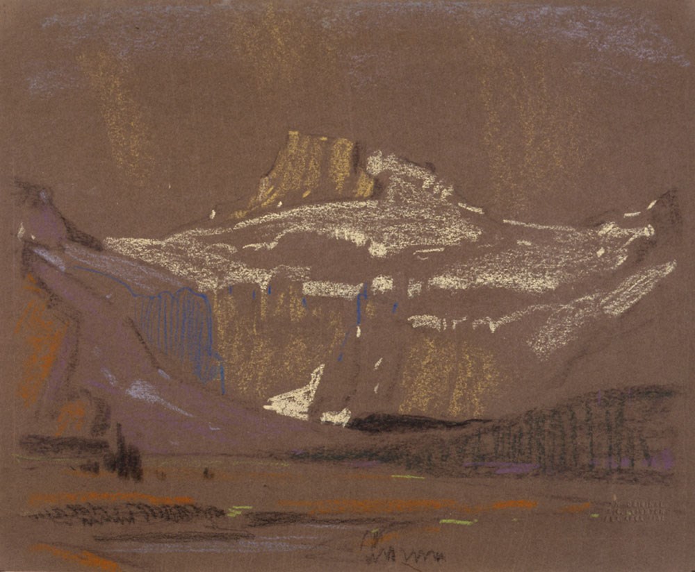
This material is presented as originally created; it may contain outdated cultural descriptions and
potentially offensive content.
Read more.
- Date
- 1963
- Medium
- graphite on paper
- Catalogue Number
- LaC.03.06
- Description
- General colour: pencil on white. Two points of land come in from left and right respectively with water in between and behind. The far shore starts quarter way up and becomes a mountain left of enter and right banks up each side. Sketchy clouds appear to be raining left and right.
- Title
- Bow Lake
- Date
- 1963
- Medium
- graphite on paper
- Dimensions
- 32.3 x 40.1 cm
- Description
- General colour: pencil on white. Two points of land come in from left and right respectively with water in between and behind. The far shore starts quarter way up and becomes a mountain left of enter and right banks up each side. Sketchy clouds appear to be raining left and right.
- Subject
- landscape
- Canadian Rockies
- mountains
- lake
- Credit
- Gift of Peter and Judith Jekill, Calgary, 1973
- Catalogue Number
- LaC.03.06
This material is presented as originally created; it may contain outdated cultural descriptions and
potentially offensive content.
Read more.
- Artist
- Fitzpatrick
- Date
- 1920 – 1930
- Medium
- ink on heavy paper
- Catalogue Number
- FiP.03.06
- Description
- A view of Bow lake, a teepee with a man in front of it, off right centre. Taken from a Byron Harmon photograph.
- Artist
- Fitzpatrick
- Title
- Bow Lake
- Date
- 1920 – 1930
- Medium
- ink on heavy paper
- Dimensions
- 27.8 x 41.7 cm
- Description
- A view of Bow lake, a teepee with a man in front of it, off right centre. Taken from a Byron Harmon photograph.
- Subject
- landscape
- Canadian Rockies
- lake
- Credit
- Gift of Don Harmon, Banff, 1978
- Catalogue Number
- FiP.03.06
This material is presented as originally created; it may contain outdated cultural descriptions and
potentially offensive content.
Read more.
Bow River Boat House 1952
https://archives.whyte.org/en/permalink/artifacthac.03.01
- Date
- 1952
- Medium
- ink on paper
- Catalogue Number
- HaC.03.01
- Description
- General colour: brown on white. Three buildings - lake in front - trees behind - a flag pole with flag rises behind the house at the right. The house at the left has a chimney and is long and narrow.
- Title
- Bow River Boat House 1952
- Date
- 1952
- Medium
- ink on paper
- Dimensions
- 15.1 x 21.5 cm
- Description
- General colour: brown on white. Three buildings - lake in front - trees behind - a flag pole with flag rises behind the house at the right. The house at the left has a chimney and is long and narrow.
- Subject
- landscape
- lake
- architecture, rural
- Credit
- Gift of Cyril Paris, Banff, 1968
- Catalogue Number
- HaC.03.01
This material is presented as originally created; it may contain outdated cultural descriptions and
potentially offensive content.
Read more.
Brochure production
https://archives.whyte.org/en/permalink/descriptions54929
- Scope & Content
- File consists of notes, clippings and drafts of brochures to be published by the Trail Riders of the Canadian Rockies. File also includes several illustrations of trail maps to be included in brochures, correspondence pertaining to brochure production, model release forms and three duplicate b&w pr…
- Date Range
- 1980-1985
- Reference Code
- M545 / V / 29 & 30
- Description Level
- 5 / File
- GMD
- Textual record
- Published record
- Organization record
- Description Level
- 5 / File
- Fonds Number
- M545 / V635
- Series
- M545 / V : Administrative records
- Sous-Fonds
- M545
- Accession Number
- 5939
- Reference Code
- M545 / V / 29 & 30
- Date Range
- 1980-1985
- Physical Description
- 2.5 cm of textual records (21.5 x 28 cm or smaller) -- 3 photographs : b&w prints ; 9 x 9 cm
- Scope & Content
- File consists of notes, clippings and drafts of brochures to be published by the Trail Riders of the Canadian Rockies. File also includes several illustrations of trail maps to be included in brochures, correspondence pertaining to brochure production, model release forms and three duplicate b&w prints depicting several trail riders on horseback [image used in 1980 brochure].
- Notes
- Six "Holiday on Horseback" brochures removed from file. Items are duplicates of brochures processed in series M545 / II and will be offered for return to Trail Riders of the Canadian Rockies.
- File contents organized by date and stored in two folders [see "Content Details"]
- Subject Access
- Administration
- Advertising
- Tourism
- Travel
- Organizations
- Membership
- Businesses
- Geography
- Horse packing
- Horseback riding
- Trails
- Hotels
- Geographic Access
- Canada
- Alberta
- Calgary
- Banff
- Language
- English
- Conservation
- Prints placed in mylar and stored in folder with related textual material to preserve context
- Category
- Exploration, discovery and travel
- Sports, recreation and leisure
- Communications
- Commerce and industry
- Title Source
- Title based on contents of file
- Processing Status
- Processed
This material is presented as originally created; it may contain outdated cultural descriptions and
potentially offensive content.
Read more.
- Date
- 1924
- Medium
- graphite on paper
- Catalogue Number
- JaA.03.06
- Description
- Pencil sketch of foothills with mountain range in background. A river indicated in foreground flows from left bottom corner to right, brc is river bank. Light and heavy pencil lines with shading, indicating trees and hills. Colour notes throughout. Drawing made on light sketchbook paper, serra…
1 image
- Title
- Burnt Wood
- Date
- 1924
- Medium
- graphite on paper
- Dimensions
- 20.7 x 27.8 cm
- Description
- Pencil sketch of foothills with mountain range in background. A river indicated in foreground flows from left bottom corner to right, brc is river bank. Light and heavy pencil lines with shading, indicating trees and hills. Colour notes throughout. Drawing made on light sketchbook paper, serrated top edge, rounded corners bl and br.
- Credit
- Gift of Naomi Jackson Groves, Ottawa, 1989
- Catalogue Number
- JaA.03.06
Images
This material is presented as originally created; it may contain outdated cultural descriptions and
potentially offensive content.
Read more.
Camp coordinator packages, notes and handouts
https://archives.whyte.org/en/permalink/descriptions54472
- Scope & Content
- File consists of introductory packages put together for Camp Coordinators on pack trips led by the Trail Riders of the Canadian Rockies in 2008. File includes contact lists, name lists and basic information about riders, participant reports, printed maps and brochures pertaining to specific packing…
- Date Range
- 2008
- Reference Code
- M545 / II / 14
- Description Level
- 5 / File
- GMD
- Textual record
- Organization record
- Map
- Postcard
- Description Level
- 5 / File
- Fonds Number
- M545 / V635
- Series
- M545 / II : Members, Staff, Personal Content
- Sous-Fonds
- M545
- Accession Number
- 8235
- Reference Code
- M545 / II / 14
- Date Range
- 2008
- Physical Description
- 1.5 cm of textual records
- Scope & Content
- File consists of introductory packages put together for Camp Coordinators on pack trips led by the Trail Riders of the Canadian Rockies in 2008. File includes contact lists, name lists and basic information about riders, participant reports, printed maps and brochures pertaining to specific packing trips in 2008, blank survey sheets and insurance waivers, and itineraries. Items are kept in order of 2008 ride numbers: Ride 1, Ride 2, etc.
- Notes
- Contains numerous duplicates
- Subject Access
- Administration
- Packing
- Travel
- Tourism
- Geography
- Geographic Access
- Canada
- Alberta
- Kananaskis
- Banff
- Access Restrictions
- Restrictions may apply due to personal information
- Reproduction Restrictions
- Restrictions may apply due to personal information
- Language
- English
- Category
- Sports, recreation and leisure
- Title Source
- Title based on contents of file
- Processing Status
- Processed
This material is presented as originally created; it may contain outdated cultural descriptions and
potentially offensive content.
Read more.
Canada's Great Highway and The Rockies of Canada
https://archives.whyte.org/en/permalink/descriptions54158
- Part Of
- Nicholas Morant fonds
- Scope & Content
- File consists of 2 published books. Contains 1 copy of 'Canada's Great Highway: from the First Stake to the Last Spike' by J.H.E. Secretan (1924), annotated by Nicholas Morant; and 1 copy of 'The Rockies of Canada' by Walter D. Wilcox (1909) with topographical map of the Rocky Mountain region in ba…
- Date Range
- 1909
- 1924
- Reference Code
- M300 / III / D / 5 / 46 to 47
- Description Level
- 5 / File
- GMD
- Textual record
- Published record
- Map
- Part Of
- Nicholas Morant fonds
- Description Level
- 5 / File
- Fonds Number
- M300 / S20 / V500
- Sous-Fonds
- M300
- Sub-Series
- M300 / III / D / 5 : Personal Interest and Gifts
- Accession Number
- 7784
- Reference Code
- M300 / III / D / 5 / 46 to 47
- Responsibility
- Produced by J.H.E. Secretan and Walter D. Wilcox
- Date Range
- 1909
- 1924
- Physical Description
- 2 Textual records: books
- Scope & Content
- File consists of 2 published books. Contains 1 copy of 'Canada's Great Highway: from the First Stake to the Last Spike' by J.H.E. Secretan (1924), annotated by Nicholas Morant; and 1 copy of 'The Rockies of Canada' by Walter D. Wilcox (1909) with topographical map of the Rocky Mountain region in back pocket.
- Storage Range
- In file box M300 / III / D / 5 / 46 to M300 / III / D / 5 / 47.
- Geographic Access
- Canada
- Canadian Rocky Mountains
- Access Restrictions
- Items in this file are not to be accessed or distributed without the explicit permission of their identified copyright owners.
- Reproduction Restrictions
- Items in this file are not to be reproduced without the explicit permission of their identified copyright owners.
- Language
- English
- Conservation
- Items in this file with risky materials attached, such as adhesives, must be covered with an acid-free paper barrier to protect adjacent items.
- Creator
- Nicholas Morant
- Title Source
- Title based on contents of file
- Processing Status
- Processed
This material is presented as originally created; it may contain outdated cultural descriptions and
potentially offensive content.
Read more.