Narrow Results By
- Peter Whyte (1905 – 1966, Canadian) 802
- Charles John Collings (1848 – 1931, British) 515
- Catharine Robb Whyte, O. C. (1906 – 1979, Canadian) 77
- Peter or Catharine Whyte 71
- Les Graff (1936 – , Canadian) 50
- Henry George Glyde (1906 – 1998, Canadian) 36
- Norah Drummond-Davies (1862 – 1949, Canadian) 14
- Peggy Dixon 7
- Pond, Peter 6
- Robert William Sinclair (1939 – , Canadian) 6
- James McLaren Nicoll (1892 – 1986, Canadian) 5
- Alfred Crocker Leighton, R. C. A. (1901 – 1965, Canadian) 4
- Medium
- Library - Maps and blueprints (unannotated; published)
- Map
- Published Date
- 1922
- Publisher
- National Geographic Society
- Call Number
- C13-7.1
- Publisher
- National Geographic Society
- Published Date
- 1922
- Scale
- 1" = 185 miles
- Subjects
- Africa
- Notes
- there is a duplicate
- Accession Number
- 400
- 576
- Call Number
- C13-7.1
- Collection
- Archives Library
This material is presented as originally created; it may contain outdated cultural descriptions and
potentially offensive content.
Read more.
[Africa, Northwestern]
https://archives.whyte.org/en/permalink/catalogue24841
- Medium
- Library - Maps and blueprints (unannotated; published)
- Map
- Published Date
- 1966
- Publisher
- National Geographic Society
- Call Number
- C13-7.3
- Publisher
- National Geographic Society
- Published Date
- 1966
- Scale
- Scale: 125 miles to 1 inch
- Relief: Bench marks
- Subjects
- Northwestern Africa
- Call Number
- C13-7.3
- Collection
- Archives Library
This material is presented as originally created; it may contain outdated cultural descriptions and
potentially offensive content.
Read more.
[Africa, Southern]
https://archives.whyte.org/en/permalink/catalogue24840
- Medium
- Library - Maps and blueprints (unannotated; published)
- Map
- Published Date
- 1962
- Publisher
- National Geographic Society
- Call Number
- C13-7.2
- Publisher
- National Geographic Society
- Published Date
- 1962
- Scale
- Scale: 125 miles to 1 inch
- Relief: bench marks
- Subjects
- Southern Africa
- Accession Number
- 495
- Call Number
- C13-7.2
- Collection
- Archives Library
This material is presented as originally created; it may contain outdated cultural descriptions and
potentially offensive content.
Read more.
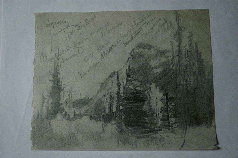
Agassiz, Yale District
https://archives.whyte.org/en/permalink/artifactcoj.03.422
- Date
- c. 1920
- Medium
- graphite on paper
- Catalogue Number
- CoJ.03.422
- Description
- A drawing of a mountain stream by trees in foreground. Heavy shading/pencil use.Cursive writing denotes details and colour scheme.
1 image
- Title
- Agassiz, Yale District
- Date
- c. 1920
- Medium
- graphite on paper
- Dimensions
- 20.0 x 26.0 cm
- Description
- A drawing of a mountain stream by trees in foreground. Heavy shading/pencil use.Cursive writing denotes details and colour scheme.
- Subject
- landscape
- Credit
- Gift of John Rivette, Seymour Arm, 1997
- Catalogue Number
- CoJ.03.422
Images
This material is presented as originally created; it may contain outdated cultural descriptions and
potentially offensive content.
Read more.
[Aishihik Lake 115H, Yukon]
https://archives.whyte.org/en/permalink/catalogue24002
- Medium
- Library - Maps and blueprints (unannotated; published)
- Map
- Published Date
- 1971
- Publisher
- Dept. of Energy, Mines and Resources
- Call Number
- NTS
- 115H
- Publisher
- Dept. of Energy, Mines and Resources
- Published Date
- 1971
- Physical Description
- 1 map : col
- Scale
- Scale: 1:250,000
- Relief: Contour interval 500 ft.
- Subjects
- Aishihik Lake
- Yukon Territory
- Notes
- National Topographic System
- Accession Number
- 3000
- Call Number
- NTS
- 115H
- Collection
- Archives Library
This material is presented as originally created; it may contain outdated cultural descriptions and
potentially offensive content.
Read more.
Alaska as a frontier of defence to Japan
https://archives.whyte.org/en/permalink/catalogue21517
- Medium
- Library - Maps and blueprints (unannotated; published)
- Map
- Published Date
- August 2, 1942
- Publisher
- Victoria newspaper
- Call Number
- C13-1.16
- Publisher
- Victoria newspaper
- Published Date
- August 2, 1942
- Subjects
- Alaska, United States
- Notes
- Article from Victoria newspaper
- Accession Number
- 400
- Call Number
- C13-1.16
- Collection
- Archives Library
This material is presented as originally created; it may contain outdated cultural descriptions and
potentially offensive content.
Read more.
[Albas 82M/3 East, B.C.]
https://archives.whyte.org/en/permalink/catalogue23445
- Medium
- Library - Maps and blueprints (unannotated; published)
- Map
- Published Date
- 1961
- Publisher
- Dept. of Mines and Technical Surveys
- Call Number
- NTS
- 82M/3E
- Publisher
- Dept. of Mines and Technical Surveys
- Published Date
- 1961
- Physical Description
- 1 map : black and white
- Scale
- Scale: 1:50,000
- Relief: Contour interval 100 ft.
- Subjects
- Albas
- British Columbia
- Notes
- National Topographic System
- Accession Number
- 3000
- Call Number
- NTS
- 82M/3E
- Collection
- Archives Library
This material is presented as originally created; it may contain outdated cultural descriptions and
potentially offensive content.
Read more.
[Albas 82M/3 West, B.C.]
https://archives.whyte.org/en/permalink/catalogue23446
- Medium
- Library - Maps and blueprints (unannotated; published)
- Map
- Published Date
- 1961
- Publisher
- Dept. of Mines and Technical Surveys
- Call Number
- NTS
- 82M/3W
- Publisher
- Dept. of Mines and Technical Surveys
- Published Date
- 1961
- Physical Description
- 1 map : black and white
- Scale
- Scale: 1:50,000
- Relief: Contour interval 100 ft.
- Subjects
- Albas
- British Columbia
- Notes
- National Topographic System
- Accession Number
- 3000
- Call Number
- NTS
- 82M/3W
- Collection
- Archives Library
This material is presented as originally created; it may contain outdated cultural descriptions and
potentially offensive content.
Read more.
- Medium
- Library - Maps and blueprints (unannotated; published)
- Map
- Published Date
- 1927
- Publisher
- Dept. of the Interior, Ottawa
- Call Number
- C9-1.2
- Publisher
- Dept. of the Interior, Ottawa
- Published Date
- 1927
- Physical Description
- 1 map: col
- Scale
- Scale: 12 1/2 miles: 1 inch
- Subjects
- Alberta
- Accession Number
- 400
- Call Number
- C9-1.2
- Collection
- Archives Library
This material is presented as originally created; it may contain outdated cultural descriptions and
potentially offensive content.
Read more.
Alberta : Athabaska sheet
https://archives.whyte.org/en/permalink/catalogue24415
- Medium
- Library - Maps and blueprints (unannotated; published)
- Map
- Published Date
- 1914
- Publisher
- Ottawa: Office of the Surveyor General
- Edition
- 2d ed.
- Call Number
- C9-2.4
- Edition
- 2d ed.
- Publisher
- Ottawa: Office of the Surveyor General
- Published Date
- 1914
- Physical Description
- 1 map
- Scale
- Scale: 1:190,080
- Subjects
- Athabaska River
- Notes
- Sectional map
- Accession Number
- 5576
- 4008
- Call Number
- C9-2.4
- Collection
- Archives Library
This material is presented as originally created; it may contain outdated cultural descriptions and
potentially offensive content.
Read more.
[Alberta] 2 sections
https://archives.whyte.org/en/permalink/catalogue24382
- Medium
- Library - Maps and blueprints (unannotated; published)
- Map
- Published Date
- 1965
- Publisher
- Dept. of Highways, Alberta
- Call Number
- C9-1.3(a)
- Publisher
- Dept. of Highways, Alberta
- Published Date
- 1965
- Physical Description
- 1 map : col
- Scale
- Scale: 12 miles: 1 inch
- Accession Number
- 673
- Call Number
- C9-1.3(a)
- Collection
- Archives Library
This material is presented as originally created; it may contain outdated cultural descriptions and
potentially offensive content.
Read more.
[Alberta] 2 sections
https://archives.whyte.org/en/permalink/catalogue24383
- Medium
- Library - Maps and blueprints (unannotated; published)
- Map
- Published Date
- 1967
- Publisher
- Dept. of Highways, Alberta
- Call Number
- C9-1.3(b)
- Publisher
- Dept. of Highways, Alberta
- Published Date
- 1967
- Physical Description
- 1 map : col
- Scale
- Scale: 12 miles: 1 inch
- Subjects
- Alberta
- Accession Number
- 673
- Call Number
- C9-1.3(b)
- Collection
- Archives Library
This material is presented as originally created; it may contain outdated cultural descriptions and
potentially offensive content.
Read more.
[Alberta] 2 sections
https://archives.whyte.org/en/permalink/catalogue24384
- Medium
- Library - Maps and blueprints (unannotated; published)
- Map
- Published Date
- 1974
- Publisher
- Surveys Branch, Department of Highways and Transport
- Call Number
- C9-1.3(c)
- Publisher
- Surveys Branch, Department of Highways and Transport
- Published Date
- 1974
- Physical Description
- 1 map : col
- Scale
- Scale: 12 miles: 1 inch
- Subjects
- Alberta
- Accession Number
- SG7500
- Call Number
- C9-1.3(c)
- Collection
- Archives Library
This material is presented as originally created; it may contain outdated cultural descriptions and
potentially offensive content.
Read more.
[Alberta Agriculture]
https://archives.whyte.org/en/permalink/catalogue24441
- Medium
- Library - Maps and blueprints (unannotated; published)
- Map
- Published Date
- 1974
- Publisher
- Surveys Branch, Department of Highways and Transport
- Call Number
- C9-5.11
- Publisher
- Surveys Branch, Department of Highways and Transport
- Published Date
- 1974
- Scale
- Scale: 1":40 miles
- Subjects
- Alberta
- Agriculture
- Notes
- Coloured areas denote Agricultural Regions
- Accession Number
- SG7500
- Call Number
- C9-5.11
- Collection
- Archives Library
This material is presented as originally created; it may contain outdated cultural descriptions and
potentially offensive content.
Read more.
Alberta agriculture
https://archives.whyte.org/en/permalink/catalogue24443
- Medium
- Library - Maps and blueprints (unannotated; published)
- Map
- Published Date
- 1978
- Publisher
- Produced by Surveys and Mapping Branch, Alberta Transportation
- Call Number
- C9-5.11b
- Publisher
- Produced by Surveys and Mapping Branch, Alberta Transportation
- Published Date
- 1978
- Physical Description
- 1 map : col
- Scale
- Scale: 1 inch = 40 miles
- Subjects
- Agriculture
- Alberta
- Notes
- Shows agricultural districts and offices
- Accession Number
- 3168
- Call Number
- C9-5.11b
- Collection
- Archives Library
This material is presented as originally created; it may contain outdated cultural descriptions and
potentially offensive content.
Read more.
[Alberta Air Facilities Map]
https://archives.whyte.org/en/permalink/catalogue24802
- Medium
- Library - Maps and blueprints (unannotated; published)
- Map
- Published Date
- 1970
- Publisher
- Department of Lands and Forests
- Call Number
- C12-4.19
- Publisher
- Department of Lands and Forests
- Published Date
- 1970
- Scale
- 1 inch = 16 miles
- Subjects
- Alberta Air Facilities Map
- Accession Number
- 2000
- Call Number
- C12-4.19
- Collection
- Archives Library
This material is presented as originally created; it may contain outdated cultural descriptions and
potentially offensive content.
Read more.
Alberta and British Columbia [road map]
https://archives.whyte.org/en/permalink/catalogue24411
- Medium
- Library - Maps and blueprints (unannotated; published)
- Map
- Published Date
- 1953
- Publisher
- Imperial Esso Touring Service
- Call Number
- C9-1.21
- Publisher
- Imperial Esso Touring Service
- Published Date
- 1953
- Physical Description
- 8 maps on 1 sheet : col
- Scale
- Scale: 1 inch = ca 30 1/2 miles
- Subjects
- Alberta
- British Columbia
- Notes
- Contents : Alberta. -- British Columbia
- Insets feature maps of Edmonton, Calgary, Vancouver, Victoria, Alaska Highway, Fraser Valley. Cover features Waterton Lakes with Prince of Wales Hotel
- Accession Number
- 6787
- Call Number
- C9-1.21
- Collection
- Archives Library
This material is presented as originally created; it may contain outdated cultural descriptions and
potentially offensive content.
Read more.
Alberta, Assiniboia, Athabasca and Saskatchewan
https://archives.whyte.org/en/permalink/catalogue24579
- Medium
- Library - Maps and blueprints (unannotated; published)
- Map
- Published Date
- 188-?
- Publisher
- Chicago : George F. Cram
- Call Number
- C11-6.1d
- Publisher
- Chicago : George F. Cram
- Published Date
- 188-?
- Physical Description
- 1 map : col
- Scale
- 1 inch = ca 40 miles
- Subjects
- The West, Canadian
- Alberta
- Notes
- Index on reverse
- Accession Number
- 16,000
- Call Number
- C11-6.1d
- Collection
- Archives Library
This material is presented as originally created; it may contain outdated cultural descriptions and
potentially offensive content.
Read more.
Alberta, Assiniboia, Athabasca, Saskatchewan
https://archives.whyte.org/en/permalink/catalogue24577
- Medium
- Library - Maps and blueprints (unannotated; published)
- Map
- Published Date
- 188-?
- Publisher
- Chicago : George F. Cram?
- Call Number
- C11-6.1b
- Publisher
- Chicago : George F. Cram?
- Published Date
- 188-?
- Scale
- 1 inch = 40 miles
- Subjects
- The West, Canadian
- Notes
- Manitoba on reverse
- Accession Number
- 16,000
- Call Number
- C11-6.1b
- Collection
- Archives Library
This material is presented as originally created; it may contain outdated cultural descriptions and
potentially offensive content.
Read more.
Alberta, Canada : forest resources, 1980
https://archives.whyte.org/en/permalink/catalogue24882
- Medium
- Library - Maps and blueprints (unannotated; published)
- Map
- Published Date
- 1980
- Publisher
- [Edmonton : Alberta Transportation]
- Call Number
- C14-4.3
- Publisher
- [Edmonton : Alberta Transportation]
- Published Date
- 1980
- Physical Description
- 1 map : col
- Scale
- Scale indeterminable
- Accession Number
- 3287
- Call Number
- C14-4.3
- Collection
- Archives Library
This material is presented as originally created; it may contain outdated cultural descriptions and
potentially offensive content.
Read more.