Narrow Results By
- Photograph 751
- Negative 300
- Transparency 281
- Lantern slide
- Map
- Library - Maps and blueprints (unannotated; published) 231
- Library - Book (including soft-cover and pamphlets) 112
- Textual record 99
- Organization record 71
- Chromogenic Colour Print Photograph 51
- Photograph print 49
- Library - Periodical 29
Hermann Hagedorn fonds
https://archives.whyte.org/en/permalink/descriptions203
- Part Of
- Hermann Hagedorn fonds
- Scope & Content
- Fonds consists of research papers and drafts, 1963-1964, and photographs, ca.1880-1930, pertaining to Walking Buffalo and Moral Rearmament, John MacLean, David McDougall, John McDougall, ranches, Andrew Sibbald and Stoney Indians. Research papers include correspondence, interview notes, narrative …
- Date Range
- [ca.1880]-1964, predominant 1963-1964
- Reference Code
- M396 / V482
- Description Level
- 1 / Fonds
- GMD
- Photograph
- Photograph print
- Textual record
- Map
- Private record
- Published record
- Part Of
- Hermann Hagedorn fonds
- Description Level
- 1 / Fonds
- Fonds Number
- M 396
- V 482
- Sous-Fonds
- M 396
- V 482
- Accession Number
- 2841
- Reference Code
- M396 / V482
- Date Range
- [ca.1880]-1964, predominant 1963-1964
- Physical Description
- 9 cm of textual records. -- 3 photographs : prints
- History / Biographical
- Hermann Hagedorn was an American writer who was known for his biographical works, particularly on Theodore Roosevelt, as well as poetry and novels. Late in life, Hagedorn became interested in Moral Rearmament. During a visit to the movement's headquarters on Mackinac Island, Michigan in 1958, he met George McLean (Chief Walking Buffalo of the Stoney Indians), an active proponent and traveller on behalf of Moral Rearmament. Intrigued by McLean's character and philosophy, Hagedorn wrote articles as well as drafts of a biography tentatively titled "A Chief in Two Worlds," but died before the work could be completed.
- Scope & Content
- Fonds consists of research papers and drafts, 1963-1964, and photographs, ca.1880-1930, pertaining to Walking Buffalo and Moral Rearmament, John MacLean, David McDougall, John McDougall, ranches, Andrew Sibbald and Stoney Indians. Research papers include correspondence, interview notes, narrative notes, miscellaneous notes, notes from published sources, photocopies and maps. Drafts include an outline and incomplete draft of "A Chief in Two Worlds"; and drafts of "The Man Who Was Needed" article.
- Access Restrictions
- No restrictions on access
- Copyright, privacy, commercial use and other restrictions may apply
- Language
- Language is English
- Finding Aid
- Finding aids and reference tools: arrangement outline
- Creator
- Hagedorn, Hermann
- Title Source
- Title based on accession record
- Processing Status
- Processed
This material is presented as originally created; it may contain outdated cultural descriptions and
potentially offensive content.
Read more.
[Abruzzi, Mount 82J/6 East, B.C.]
https://archives.whyte.org/en/permalink/catalogue23438
- Medium
- Library - Maps and blueprints (unannotated; published)
- Map
- Published Date
- 1966
- Publisher
- Dept. of Mines and Technical Surveys
- Call Number
- NTS
- 82J/6E
- Publisher
- Dept. of Mines and Technical Surveys
- Published Date
- 1966
- Physical Description
- 1 map : col
- Scale
- Scale: 1:50,000
- Relief: Contour interval 100'
- Subjects
- Mount Abruzzi
- British Columbia
- Notes
- National Topographic System
- Accession Number
- 718
- Call Number
- NTS
- 82J/6E
- Collection
- Archives Library
This material is presented as originally created; it may contain outdated cultural descriptions and
potentially offensive content.
Read more.
[Abruzzi, Mount 82J/6 West, B.C.]
https://archives.whyte.org/en/permalink/catalogue23437
- Medium
- Library - Maps and blueprints (unannotated; published)
- Map
- Published Date
- 1966
- Publisher
- Dept. of Mines and Technical Surveys
- Call Number
- NTS
- 82J/6W
- Publisher
- Dept. of Mines and Technical Surveys
- Published Date
- 1966
- Physical Description
- 1 map : col
- Scale
- Scale: 1:50,000
- Relief: Contour interval 100'
- Subjects
- Mount Abruzzi
- British Columbia
- Notes
- National Topographic System
- Accession Number
- 718
- Call Number
- NTS
- 82J/6W
- Collection
- Archives Library
This material is presented as originally created; it may contain outdated cultural descriptions and
potentially offensive content.
Read more.
[Adams Plateau 82M/4 East, B.C.]
https://archives.whyte.org/en/permalink/catalogue23441
- Medium
- Library - Maps and blueprints (unannotated; published)
- Map
- Published Date
- 1961
- Publisher
- Department of Mines and Technical Surveys
- Call Number
- NTS
- 82M/4E
- Publisher
- Department of Mines and Technical Surveys
- Published Date
- 1961
- Physical Description
- 1 map : col
- Scale
- Scale: 1:50,000
- Relief: Contour interval 100 ft.
- Subjects
- Adams Plateau
- British Columbia
- Notes
- National Topographic System
- Accession Number
- 7000
- Call Number
- NTS
- 82M/4E
- Collection
- Archives Library
This material is presented as originally created; it may contain outdated cultural descriptions and
potentially offensive content.
Read more.
[Adams Plateau 82M/4 West, B.C.]
https://archives.whyte.org/en/permalink/catalogue23442
- Medium
- Library - Maps and blueprints (unannotated; published)
- Map
- Published Date
- 1961
- Publisher
- Department of Mines and Technical Surveys
- Call Number
- NTS
- 82M/4W
- Publisher
- Department of Mines and Technical Surveys
- Published Date
- 1961
- Physical Description
- 1 map : col
- Scale
- Scale: 1:50,000
- Relief: Contour interval 100 ft.
- Subjects
- Adams Plateau
- British Columbia
- Notes
- National Topographic System
- Accession Number
- 7000
- Call Number
- NTS
- 82M/4W
- Collection
- Archives Library
This material is presented as originally created; it may contain outdated cultural descriptions and
potentially offensive content.
Read more.
[Adams River 82M/11 East, B.C.]
https://archives.whyte.org/en/permalink/catalogue23443
- Medium
- Library - Maps and blueprints (unannotated; published)
- Map
- Published Date
- 1961
- Publisher
- Dept. of Mines and Technical Surveys
- Call Number
- NTS
- 82M/11E
- Publisher
- Dept. of Mines and Technical Surveys
- Published Date
- 1961
- Physical Description
- 1 map : col
- Scale
- Scale: 1:50,000
- Relief: Contour interval 100 ft.
- Subjects
- Adams River
- British Columbia
- Notes
- National Topographic System
- Accession Number
- 3000
- Call Number
- NTS
- 82M/11E
- Collection
- Archives Library
This material is presented as originally created; it may contain outdated cultural descriptions and
potentially offensive content.
Read more.
[Adams River 82M/11 West, B.C.]
https://archives.whyte.org/en/permalink/catalogue23444
- Medium
- Library - Maps and blueprints (unannotated; published)
- Map
- Published Date
- 1961
- Publisher
- Dept. of Mines and Technical Surveys
- Call Number
- NTS
- 82M/11W
- Publisher
- Dept. of Mines and Technical Surveys
- Published Date
- 1961
- Physical Description
- 1 map : col
- Scale
- Scale: 1:50,000
- Relief: Contour interval 100 ft.
- Subjects
- Adams River
- British Columbia
- Notes
- National Topographic System
- Accession Number
- 3000
- Call Number
- NTS
- 82M/11W
- Collection
- Archives Library
This material is presented as originally created; it may contain outdated cultural descriptions and
potentially offensive content.
Read more.
[Albas 82M/3 East, B.C.]
https://archives.whyte.org/en/permalink/catalogue23445
- Medium
- Library - Maps and blueprints (unannotated; published)
- Map
- Published Date
- 1961
- Publisher
- Dept. of Mines and Technical Surveys
- Call Number
- NTS
- 82M/3E
- Publisher
- Dept. of Mines and Technical Surveys
- Published Date
- 1961
- Physical Description
- 1 map : black and white
- Scale
- Scale: 1:50,000
- Relief: Contour interval 100 ft.
- Subjects
- Albas
- British Columbia
- Notes
- National Topographic System
- Accession Number
- 3000
- Call Number
- NTS
- 82M/3E
- Collection
- Archives Library
This material is presented as originally created; it may contain outdated cultural descriptions and
potentially offensive content.
Read more.
[Albas 82M/3 West, B.C.]
https://archives.whyte.org/en/permalink/catalogue23446
- Medium
- Library - Maps and blueprints (unannotated; published)
- Map
- Published Date
- 1961
- Publisher
- Dept. of Mines and Technical Surveys
- Call Number
- NTS
- 82M/3W
- Publisher
- Dept. of Mines and Technical Surveys
- Published Date
- 1961
- Physical Description
- 1 map : black and white
- Scale
- Scale: 1:50,000
- Relief: Contour interval 100 ft.
- Subjects
- Albas
- British Columbia
- Notes
- National Topographic System
- Accession Number
- 3000
- Call Number
- NTS
- 82M/3W
- Collection
- Archives Library
This material is presented as originally created; it may contain outdated cultural descriptions and
potentially offensive content.
Read more.
Alberta and British Columbia [road map]
https://archives.whyte.org/en/permalink/catalogue24411
- Medium
- Library - Maps and blueprints (unannotated; published)
- Map
- Published Date
- 1953
- Publisher
- Imperial Esso Touring Service
- Call Number
- C9-1.21
- Publisher
- Imperial Esso Touring Service
- Published Date
- 1953
- Physical Description
- 8 maps on 1 sheet : col
- Scale
- Scale: 1 inch = ca 30 1/2 miles
- Subjects
- Alberta
- British Columbia
- Notes
- Contents : Alberta. -- British Columbia
- Insets feature maps of Edmonton, Calgary, Vancouver, Victoria, Alaska Highway, Fraser Valley. Cover features Waterton Lakes with Prince of Wales Hotel
- Accession Number
- 6787
- Call Number
- C9-1.21
- Collection
- Archives Library
This material is presented as originally created; it may contain outdated cultural descriptions and
potentially offensive content.
Read more.
[Alert Bay 92L, B.C.]
https://archives.whyte.org/en/permalink/catalogue24003
- Medium
- Library - Maps and blueprints (unannotated; published)
- Map
- Published Date
- 1965
- Publisher
- Army Survey Establishment
- Call Number
- NTS
- 92L
- Publisher
- Army Survey Establishment
- Published Date
- 1965
- Physical Description
- 1 map : col
- Scale
- Scale: 1:250,00
- Relief: Contour interval 500 ft.
- Subjects
- Alert Bay
- British Columbia
- Notes
- National Topographic System
- Accession Number
- 5500
- Call Number
- NTS
- 92L
- Collection
- Archives Library
This material is presented as originally created; it may contain outdated cultural descriptions and
potentially offensive content.
Read more.
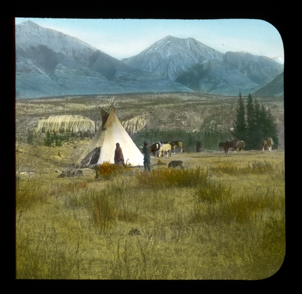
An Indian Home on the Saskatchewan [River]
https://archives.whyte.org/en/permalink/descriptions39203
- Part Of
- Moore family fonds
- Date Range
- [1907]
- Reference Code
- V439 / PS - 29
- Description Level
- 6 / Item
- GMD
- Photograph
- Lantern slide
- Transparency
1 image
- Part Of
- Moore family fonds
- Description Level
- 6 / Item
- Fonds Number
- M307 / V439
- Series
- I. Philip Moore series
- Sous-Fonds
- V439
- Sub-Series
- B. Professional papers and photographs 2. Research, writing and lecturing d. Photographs i. Lantern slides (transparencies)
- Reference Code
- V439 / PS - 29
- Date Range
- [1907]
- Physical Description
- 1 transparency : lantern slide
- Subject Access
- Buildings and memorials
- Discovery and Exploration
- Environment and Nature
- First nations
- Geographic Access
- Alberta
- Creator
- [Mary Schaffer]
- Processing Status
- Processed
Images
This material is presented as originally created; it may contain outdated cultural descriptions and
potentially offensive content.
Read more.
[Anahim Lake 93C, B.C.]
https://archives.whyte.org/en/permalink/catalogue24005
- Medium
- Library - Maps and blueprints (unannotated; published)
- Map
- Published Date
- 1955
- Publisher
- Dept. of Mines and Technical Surveys
- Call Number
- NTS
- 93C
- Publisher
- Dept. of Mines and Technical Surveys
- Published Date
- 1955
- Physical Description
- 1 map : col
- Scale
- Scale: 1:250,000
- Relief: Contour interval 500 ft.
- Subjects
- Anahim Lake
- British Columbia
- Accession Number
- 3000
- Call Number
- NTS
- 93C
- Collection
- Archives Library
This material is presented as originally created; it may contain outdated cultural descriptions and
potentially offensive content.
Read more.
[Anahim Lake, B.C.] Canada Land Inventory Map, Land capability for wildlife-ungulates
https://archives.whyte.org/en/permalink/catalogue24004
- Medium
- Library - Maps and blueprints (unannotated; published)
- Map
- Published Date
- 1971
- Publisher
- Dept. of Energy, Mines and Resources
- Call Number
- NTS
- 93C
- Publisher
- Dept. of Energy, Mines and Resources
- Published Date
- 1971
- Physical Description
- 1 map : col
- Scale
- Scale: 1:250,000
- Subjects
- Anahim Lake
- British Columbia
- Accession Number
- 4000
- Call Number
- NTS
- 93C
- Collection
- Archives Library
This material is presented as originally created; it may contain outdated cultural descriptions and
potentially offensive content.
Read more.
[Angus Horne Lake 83D/5 B.C.]
https://archives.whyte.org/en/permalink/catalogue23450
- Medium
- Library - Maps and blueprints (unannotated; published)
- Map
- Published Date
- 1972
- Publisher
- Department of Energy, Mines and Resources
- Call Number
- NTS
- 83D/5
- Publisher
- Department of Energy, Mines and Resources
- Published Date
- 1972
- Physical Description
- 1 map : col
- Scale
- Scale: 1:50,000
- Relief: Contour interval 100 ft.
- Subjects
- Angus Horne Lake
- British Columbia
- Notes
- National Topographic System
- Accession Number
- 7000
- Call Number
- NTS
- 83D/5
- Collection
- Archives Library
This material is presented as originally created; it may contain outdated cultural descriptions and
potentially offensive content.
Read more.
Argonaut Mountain, Kootenay Land District, British Columbia
https://archives.whyte.org/en/permalink/catalogue23451
- Medium
- Library - Maps and blueprints (unannotated; published)
- Map
- Published Date
- 1980
- Publisher
- Ottawa: Surveys and Mapping Branch, Dept. of Energy, Mines and Resources
- Edition
- 2d ed.
- Call Number
- NTS
- 82M/16
- Edition
- 2d ed.
- Publisher
- Ottawa: Surveys and Mapping Branch, Dept. of Energy, Mines and Resources
- Published Date
- 1980
- Physical Description
- 1 map : col
- Scale
- Scale: 1:50,000
- Subjects
- Argonaut Mountain
- British Columbia
- Accession Number
- 27,000
- 7030
- Call Number
- NTS
- 82M/16
- Collection
- Archives Library
This material is presented as originally created; it may contain outdated cultural descriptions and
potentially offensive content.
Read more.
Arrival of Champlain
https://archives.whyte.org/en/permalink/descriptions38593
- Part Of
- Mary Schaffer fonds
- Scope & Content
- [Fur trade illustration - First Nations in canoes greeting ship]
- Date Range
- [ca. 1910]
- Reference Code
- V527 / PS 1 - 604
- Description Level
- 6 / Item
- GMD
- Photograph
- Lantern slide
- Transparency
1 image
- Part Of
- Mary Schaffer fonds
- Description Level
- 6 / Item
- Series
- II. Photography series
- Sub-Series
- A. Lantern slides 6. Fur trade
- Reference Code
- V527 / PS 1 - 604
- Date Range
- [ca. 1910]
- Physical Description
- 1 transparency : lantern slide
- Scope & Content
- [Fur trade illustration - First Nations in canoes greeting ship]
- Subject Access
- Discovery and Exploration
- Environment and Nature
- First nations
- Immigration and homesteading
- Transportation
- Geographic Access
- Canada
Images

This material is presented as originally created; it may contain outdated cultural descriptions and
potentially offensive content.
Read more.
- Medium
- Library - Maps and blueprints (unannotated; published)
- Map
- Published Date
- 1966
- Publisher
- Department of Lands & Forests
- Call Number
- NTS
- 92I/NW
- Publisher
- Department of Lands & Forests
- Published Date
- 1966
- Physical Description
- 1 map : col
- Scale
- Scale: 1:126,720
- Relief: contour interval 100 ft.
- Subjects
- Ashcroft
- British Columbia
- Notes
- National Topographic System
- Accession Number
- 3000
- Call Number
- NTS
- 92I/NW
- Collection
- Archives Library
This material is presented as originally created; it may contain outdated cultural descriptions and
potentially offensive content.
Read more.
[Ashcroft 92I, B.C.]
https://archives.whyte.org/en/permalink/catalogue24006
- Medium
- Library - Maps and blueprints (unannotated; published)
- Map
- Published Date
- 1962
- Publisher
- Dept. of Mines and Technical Surveys
- Call Number
- NTS
- 92I
- Publisher
- Dept. of Mines and Technical Surveys
- Published Date
- 1962
- Physical Description
- 1 map : col
- Scale
- Scale: 1:250,000
- Relief: Contour interval 500 ft.
- Subjects
- Ashcroft
- British Columbia
- Notes
- National Topographic System
- Accession Number
- 3000
- Call Number
- NTS
- 92I
- Collection
- Archives Library
This material is presented as originally created; it may contain outdated cultural descriptions and
potentially offensive content.
Read more.
[Ashnola 92H/1 East, B.C.]
https://archives.whyte.org/en/permalink/catalogue23452
- Medium
- Library - Maps and blueprints (unannotated; published)
- Map
- Published Date
- 1960
- Publisher
- Army Survey Establishment
- Call Number
- NTS
- 92H/1E
- Publisher
- Army Survey Establishment
- Published Date
- 1960
- Physical Description
- 1 map : col
- Scale
- Scale: 1:50,000
- Relief: Contour interval 100 ft.
- Subjects
- Ashnola
- British Columbia
- Notes
- National Topographic System
- Accession Number
- 7000
- Call Number
- NTS
- 92H/1E
- Collection
- Archives Library
This material is presented as originally created; it may contain outdated cultural descriptions and
potentially offensive content.
Read more.