Narrow Results By
Ben Gadd fonds
https://archives.whyte.org/en/permalink/descriptions55758
- Part Of
- Ben Gadd fonds
- Scope & Content
- Fonds consists of materials pertaining to Ben Gadd's personal life and career as an environmental researcher, educator, interpretive guide, publisher, public speaker and author, ca.1956-2018. Fonds includes maps, research materials, publication notes/drafts, correspondence, contracts, photographs, …
- Date Range
- 1956-2018
- Reference Code
- M590 / V810 / S61
- Description Level
- 1 / Fonds
- GMD
- Digital image
- Drawing
- Negative
- Newspaper clipping
- Photograph
- Photograph print
- Postcard
- Published record
- Textual record
- Video
- Transparency
- Part Of
- Ben Gadd fonds
- Description Level
- 1 / Fonds
- Fonds Number
- M590
- V810
- Sous-Fonds
- M590
- V810
- Accession Number
- 2021.20
- 2024.01
- Reference Code
- M590 / V810 / S61
- GMD
- Digital image
- Drawing
- Negative
- Newspaper clipping
- Photograph
- Photograph print
- Postcard
- Published record
- Textual record
- Video
- Transparency
- Date Range
- 1956-2018
- Physical Description
- ca. 7.9 metres of textual records -- ca. 274 maps -- 29 VHS tapes -- ca.15 discs with digital files -- 21 cassettes -- photographs -- oversized materials -- USB stick with 15 sldeshows
- History / Biographical
- Ben Gadd (1946-) is a retired naturalist, guide, geologist, instructor, freelance writer and award-winning author based in the Canadian Rockies. Ben was born in Colorado Springs, Colorado in 1946. He met his wife, Cia (Langdon) Gadd at Colorado College in 1965, and the couple married four weeks later. Ben and Cia had two sons, Will and Toby. Ben and his family relocated to Jasper in the late 1960s. Ben later attended the University of Lethbridge and graduated with a Bachelor's degree in Earth Science in 1972. Between 1976 and 1980, Ben taught classes at Mount Royal College and the Southern Alberta Institute of Technology; he later taught additional classes at Grant MacEwan College and Lakeland College. From 1981, Ben also worked as a seasonal naturalist/guide for Parks Canada. Ben left Parks Canada in 1985 to start an independent naturalist guiding business with Cia based in Jasper and other parts of the Canadian Rockies, which the couple continued to operate for over two decades. Ben published his best-known work, "Handbook of the Canadian Rockies", through his publishing company Corax Press in 1986. The second edition of "Handbook of the Canadian Rockies" received multiple awards after its release in 1995. Ben's fiction book, "Raven's End" won the title of Best Canadian Rockies Book at the Banff Mountain Film and Book Festival in 2001 and became a Canadian bestseller. Overall, Ben has authored or co-authored 11 books and received nearly one dozen awards for his achievements as a writer, researcher and guide. Ben continued to lead guided hikes and school programs until his retirement in 2016.
- Scope & Content
- Fonds consists of materials pertaining to Ben Gadd's personal life and career as an environmental researcher, educator, interpretive guide, publisher, public speaker and author, ca.1956-2018. Fonds includes maps, research materials, publication notes/drafts, correspondence, contracts, photographs, video and sound recordings, and other related material. Materials donated in 2024 include one USB stick containing
- Notes
- Ben Gadd fonds arrangement: Series I : Personal records - Subseries A : Travel guides and maps - Subseries B : Education and early writings - Subseries C : Personal interest files - Subseries D : Other personal and collected Series II : Research and publication records - Subseries A : Handbook of the Canadian Rockies - Subseries B : Other publications Series III : Professional records - Subseries A : Parks Canada Records - Subseries B : Interpretive guiding - Subseries C : Teaching records - Subseries D : Other contracts and projects Series IV : Legal and financial records - Subseries A : Legal records - Subseries B : Financial records
- Subject Access
- Education
- Research
- Publication
- Environment
- Geology
- Tourism
- Family and personal life
- Personal and Professional Life
- Academics
- Guiding
- Guides
- Businesses
- Finances
- Conservation
- Wildlife
- Natural history
- Sports and recreation
- Geographic Access
- Canada
- Alberta
- Jasper National Park
- Banff National Park
- Yoho National Park
- Kootenay National Park
- Lethbridge
- United States of America
- Colorado
- Canadian Rocky Mountains
- Reproduction Restrictions
- Copyright restrictions apply
- Language
- English
- French
- Dutch
- Title Source
- Title based on contents of fonds
- Processing Status
- Processed / Unprocessed
This material is presented as originally created; it may contain outdated cultural descriptions and
potentially offensive content.
Read more.
Dorothy Wardle fonds
https://archives.whyte.org/en/permalink/descriptions398
- Part Of
- Dorothy Wardle fonds
- Scope & Content
- Fonds consists of two sous-fonds: M521 and V75. M521 consists of four series, 154 cm, ca.1870-2002. Series I: Dorothy Wardle Personal Papers, 69.5 cm, ca.1870-2002 (includes Dorothy's written work and research and notes related to Banff). Series II: Wardle Family, 32.5 cm, 1872-1998 (including cor…
- Date Range
- ca.1870-2002
- Reference Code
- M521 / V75
- Description Level
- 1 / Fonds
- GMD
- Photograph
- Album
- Negative
- Photograph print
- Postcard
- Transparency
- Textual record
- Private record
- Published record
- Part Of
- Dorothy Wardle fonds
- Description Level
- 1 / Fonds
- Fonds Number
- M521
- V75
- Sous-Fonds
- M521
- V75
- Accession Number
- 5296, 5391, 7504
- Reference Code
- M521 / V75
- GMD
- Photograph
- Album
- Negative
- Photograph print
- Postcard
- Transparency
- Textual record
- Private record
- Published record
- Date Range
- ca.1870-2002
- Physical Description
- 154 cm of textual records. -- 1304 photographs (1190 prints, 95 negatives, 19 transparencies). -- 6 photograph albums.
- History / Biographical
- The Wardle family was comprised of husband and wife, James Morey Wardle (June 26,1888 - May 18,1971) and Maud Leette (Roney) Wardle (May 24,1889 - December 1,1969), and their one child, Dorothy Hope Wardle (May 23,1919 - July 20,2003). James Wardle, born in Chiliwack, British Columbia, was a civil engineer and public servant. He was the Superintendent of Banff National Park from 1918-1921, Chief Engineer for Parks Canada from 1921-1935, and Deputy Minister of the Interior from 1935-1936. He is primarily known as a highway design engineer, particularly for building the Banff-Windermere, Banff-Lake Louise, and Banff-Jasper highways. He was a councillor for the Municipality of Rockcliffe Park in Ontario and he was the President of the Trail Riders of the Canadian Rockies in Banff from 1925-1929. Mount Wardle in Vermillion was named after him in 1921. James married Leette on November 4, 1913, with whom he had one child, Dorothy. Born in Calgary, Alberta, Dorothy (also known as Dot and Dorie) grew up in Banff, Alberta and Ottawa, Ontario, due to her father's position with the federal government. She was educated at the Mountain School in Banff and at the Elmwood School in Ottawa. All three family members were graduates of Queen's University in Kingston, Ontario. James graduated in 1912 with a Bachelor of Science in Engineering, Leette graduated with a Bachelor's degree, and in 1942, Dorothy also earned a Bachelor's degree. Dorothy was prominent in student life and active in athletics. In 1941, Dorothy became the first woman elected as President of the Alma Mater Society and during her academic career, Dorothy was a member of the Levana Intercollegiate Debative, University Centenary Committee, and Queen’s War Aid Commission. Dorothy spent her career as a freelance writer however, upon graduation she served as the first Secretary-In-Charge of Records at Carleton College (now Carleton University) from 1942-1944 in Ottawa and in the mid-1950s worked as a secretary for the Glenbow Foundation in Calgary. Dorothy pursued a lifelong interest in traveling, art, and antiques. Although she was fiercely proud and protective of Banff and the Park, and remained a volunteer and patron of the Whyte Museum of the Canadian Rockies, Dorothy eventually settled in Sidney, British Columbia and shared an apartment with Sheila Iris Ritchie, with whom Dorothy travelled extensively. After her death in 2003, Dorothy, "Dorie," was laid to rest alongside her parents in the Old Banff Cemetery.
- Scope & Content
- Fonds consists of two sous-fonds: M521 and V75.
- M521 consists of four series, 154 cm, ca.1870-2002. Series I: Dorothy Wardle Personal Papers, 69.5 cm, ca.1870-2002 (includes Dorothy's written work and research and notes related to Banff). Series II: Wardle Family, 32.5 cm, 1872-1998 (including correspondence with Carl Rungius and Mrs. Helen Brett, and Christmas and other greeting cards from Peter and Catharine Whyte). Series III: Queen's University, 7.5 cm, 1911-1980 (including graduation certificates for each family member and records pertaining to Dorothy's participation on the Alma Mater Society). Series IV: Travel, 44.5 cm, ca.1950-1988 (includes hand-written notebooks meticulously detailing their travels).
- V75 consists of two series, 79.5 cm, ca. 1912-2001. Series I: Wardle Family, ca. 1912-1971, 6 albums, 31 cm of photograph prints and negatives (including family trips, trail rides in the Canadian Rocky Mountains, and family gatherings). Series II: Dorothy Wardle, 1972-2001, 34 cm of photograph prints, negatives, and transparencies (including Dorothy's travels in Alberta and British Columbia, overseas, and various outings with friends).
- Name Access
- Wardle, Dorothy
- Wardle, James
- Rungius, Carl
- Brett, Helen
- Keyte, Freeman
- Hart, E. J. (Ted)
- Harkin, J. B. (James Bernard)
- Brewster, Pat
- Peyto, Bill
- Brett, Robert George
- Sanson, Norman
- White, Clifford
- Drummond-Davies, Nora
- Mills, Ike
- McLean, George
- Walking Buffalo (George McLean)
- Kaquitts, Frank
- Oxborough, Dorothy
- Whyte, Jon
- Robinson, Dean
- Warren, Mary Schaffer
- Simpson, George
- Gibbon, John Murray
- Whyte, Catharine
- Whyte, Peter
- Greenham, Margaret
- Subject Access
- Arts
- Environment
- Personal and Family Life
- Banff
- Old Banff Cemetery
- Whyte Museum of the Canadian Rockies
- Cabins
- Travel
- Picnics and picnicking
- Holidays
- Scenery
- Christmas
- Dogs
- Horses
- Mountain
- Canoes and canoeing
- Hiking
- Wildlife
- War Memorial
- Highland Games
- Bow River Bridge
- Golfing
- Anniversary
- Horseback riding
- Indigenous Peoples
- Stoney Nakoda
- Education
- Snowshoes and snowshoeing
- Banff Winter Carnival
- Banff Winter Festival
- Women
- Trails
- Trail Riders of the Canadian Rockies
- Sports and leisure
- Skiing
- European travel
- Beach
- Calgary Herald
- Geography
- Government
- Newspaper
- Politics
- Research
- Banff Public Library
- National parks and reserves
- Park policy
- Parks Canada
- Wardens
- Ya-Ha-Tinda Ranch
- Community life
- Mines and mineral resources
- History
- Immigration and homesteading
- Settlement
- Organizations
- World War II
- Biographical
- Professional and Personal Life
- Grizzly Bears
- Fire fighters
- Sunshine Village
- Teahouses
- Banff Indian Days
- Regalia
- Calgary Stampede
- Mountain guides
- Mountain School
- The Albertan
- Crag and Canyon newspaper
- Homestead Hotel
- Banff Centre
- Hot Springs
- Superintendents
- Automobiles
- Natural history
- Records
- Calendar
- Finances
- Leases
- Legal and Financial
- Property
- Recreation
- Geographic Access
- Banff
- Banff National Park
- Canmore
- Alberta
- Canada
- Canadian Rocky Mountains
- Castle Mountain
- Bankhead
- British Columbia
- Glacier National Park
- Kootenay National Park
- Silver City
- Victoria
- Scotland
- Revelstoke
- Yoho National Park
- Ottawa
- Ontario
- Prince Edward Island
- Plain of Six Glaciers
- Lake Agnes
- Lake Louise
- Lake Minnewanka
- Lake O'Hara
- Bow River
- Calgary
- Sidney
- San Francisco
- United States
- Europe
- Germany
- Switzerland
- France
- Spain
- Monaco
- Italy
- Denmark
- Austria
- Quebec
- Windermere
- New York
- Assiniboine
- Ghost River
- High River
- Quebec City
- New Brunswick
- Maine
- Great Divide
- Moraine Lake
- Maligne Lake
- Columbia Icefield
- Washington
- Philadelphia
- Atlantic City
- Larch Valley
- Cascade Mountain
- Panama
- Sulphur Mountain
- Field
- Emerald Lake
- Head Smashed In Buffalo Jump
- Takkakaw Falls
- Jasper National Park
- Athabasca Falls
- Okanagan
- Kananaskis
- Hoodoos
- Powell River
- Montreal
- Access Restrictions
- Some restriction/s on access
- Copyright, privacy, commercial use and other restrictions may apply
- Language
- Language is English
- Related Material
- Dorothy also donated artwork (by Carl Rungius) to Art and Heritage.
- James Morey Wardle fonds (Library and Archives Canada)
- Category
- Arts
- Environment
- Education
- Exploration, discovery and travel
- Family and personal life
- First nations
- Sports, recreation and leisure
- Title Source
- Title based on accession records and contents of fonds
- Processing Status
- Processed
This material is presented as originally created; it may contain outdated cultural descriptions and
potentially offensive content.
Read more.
Jean A. Hembroff MacDonald fonds
https://archives.whyte.org/en/permalink/descriptions54681
- Part Of
- Jean A. Hembroff MacDonald fonds
- Scope & Content
- Fonds consists of three sous-fonds: M573 / V797 / S60. M573 consists of three series, 26 cm of textual records, 1924-2005. Series I: Personal Papers, 19 cm, ca.1930-2005 (including notebooks and drafts of various talks that Jean delivered and records related to her participation in the Trail Rider…
- Date Range
- ca.1908-ca.2011
- Reference Code
- M573 / V797 / S60
- Description Level
- 1 / Fonds
- GMD
- Photograph
- Photograph print
- Private record
- Published record
- Newspaper clipping
- Transparency
- Textual record
- Sound recording
- Lantern slide
- Part Of
- Jean A. Hembroff MacDonald fonds
- Description Level
- 1 / Fonds
- Fonds Number
- M573 / V797 / S60
- Sous-Fonds
- M573
- V797
- S60
- Accession Number
- 2019.111
- Reference Code
- M573 / V797 / S60
- GMD
- Photograph
- Photograph print
- Private record
- Published record
- Newspaper clipping
- Transparency
- Textual record
- Sound recording
- Lantern slide
- Date Range
- ca.1908-ca.2011
- Physical Description
- 26 cm of textual records.-- 109 photographs (42 prints, 67 lantern slides). -- 2 sound recordings.
- History / Biographical
- Jean Alexandra Hembroff was born in Winnipeg, Manitoba on April 5, 1908 to Walter B. Hembroff (d. 1945) and Sarah Jane Hembroff (d.1952). Jean was accepted to the MacPhail School of Music and Dramatic Art at the University of Minnesota, from which she graduated in 1927. She returned to Winnipeg to begin teaching courses in speech arts and drama. To establish herself, she first volunteered as the "story lady" at the Williams Avenue Public Library and quickly became known as an excellent speaker sought by many different organizations. She taught at St. Mary's Academy and the Evening Institute at the University of Manitoba, as well as offered private sessions. Many of her students used the skills they learned from Jean as they entered radio, television, politics, and business. Jean was also very active in organizing and adjucating Speech Arts festivals in Manitoba, often going to inaccessible places to give workshops. Her teaching, broadcasting, adjucating, coaching, and speaking career spanned more than 50 years. Jean was hired by the Canadian Pacific Railway's promotions manager to give presentations and broadcast interviews across Canada and the United States. In 1937, Jean joined the Trail Riders of the Canadian Rockies and participated in their summer trail ride in the same year. For that year's issue of the Trail Rider's Bulletin Jean wrote an article - and became the first woman to ever do so. In 1938, during her lecture titled "Trail Riding in the Rockies" on January 18, 1938 at the Royal Alexandra Hotel, Jean met John David (Jack) MacDonald. Jack and Jean were married on June 18, 1938, and the couple had one son, Bruce Walter James MacDonald (August 28, 1946-August 25, 2016). Jean participated in several trail rides with the Trail Riders of the Canadian Rockies and the Sky Line Trail, and produced articles reflecting her experiences. Jean loved to travel and visited places all around Canada and the United States, Borneo, Tangier, Montevideo, Stockholm, New Delhi, and Tonga. At the age of 102, Jean passed away on February 2, 2011 and is buried in Winnipeg.
- Scope & Content
- Fonds consists of three sous-fonds: M573 / V797 / S60.
- M573 consists of three series, 26 cm of textual records, 1924-2005. Series I: Personal Papers, 19 cm, ca.1930-2005 (including notebooks and drafts of various talks that Jean delivered and records related to her participation in the Trail Riders of the Canadian Rockies and the Sky Line Hikers of the Canadian Rockies, particularly 1937-1939). Series II: Correspondence and Newspaper Clippings, 4 cm, 1924-2000 (including correspondence with John Murray Gibbon, former students, and attendees at various talks, as well as newspaper articles that Jean wrote about various subjects and articles of her achievements). Series III: Collected Materials and Ephemera, 3 cm, ca.1930-1950 (including a variety of collected poems and ephemera, as well as a copy of The Beaver Magazine from 1940, for which Jean wrote an article titled "On the Trail of Sir George").
- V797 consists of two series, 24.5 cm of visual records, ca.1928-1939. Series I: Photograph Prints, 3 cm, ca.1928-1939 (includes personal photographs of Jean and her family and friends as well as photographs of Jean and Jack's visit to Lake Louise in 1939). Series II: Lantern Slides, 21.5 cm, ca.1937-1939 (Trail Riders of the Canadian Rockies official ride of 1937 to Mt. Assiniboine; Sky Line Hikers of the Canadian Rockies official ride of 1939 to Ptarmigan Valley and Skoki; collection of trail ride songs).
- S60 consists of two sound recordings, 1 cm, 2004 and 2007 (Winnipeg at Christmas, narrated by Jean, broadcasted on the Canadian Broadcasting Corporation).
- Notes
- Lantern slides include wooden case.
- Name Access
- Hembroff MacDonald, Jean
- Subject Access
- Banff
- Banff National Park
- Camps
- Canadian Pacific Railway
- Discovery and travel
- Discovery and exploration
- Empress Hotel
- European travel
- Family and personal life
- Guides
- Hiking
- Horse packing
- Horses
- Horseback riding
- Kananaskis Ranch
- Lake Louise
- Lantern slide
- Mount Assiniboine
- Mountain
- Organizations
- Personal and Professional Life
- Photography
- Poetry
- Scenery
- Skyline Hikers of the Canadian Rockies
- Skyline Trail Hikers of the Canadian Rockies
- Sports and recreation
- Sunshine area
- Trails
- Trail guides
- Tourism
- Travel
- Travel and Exploration
- Trail Riders of the Canadian Rockies
- Women
- Geographic Access
- Assiniboine
- Alberta
- Banff
- Banff National Park
- British Columbia
- Canada
- Canadian Rocky Mountains
- Ireland
- Kananaskis Country
- Lake Louise
- Lake O'Hara
- Manitoba
- Mount Assiniboine
- Rocky Mountains
- Victoria
- West Indies
- Winnipeg
- Reproduction Restrictions
- Some restriction/s on access
- Copyright, privacy, commercial use and other restrictions may apply
- Language
- English
- Creator
- Hembroff MacDonald, Jean
- Biographical Source Notes
- Contents of the fonds
- https://www.findagrave.com/memorial/122854759/jean-alexandra-macdonald
- https://passages.winnipegfreepress.com/passage-details/id-174851/MACDONALD_JEAN
- https://www.dignitymemorial.com/obituaries/winnipeg-mb/bruce-macdonald-7064958
- Title Source
- Title based on contents of file
- Processing Status
- Processed
This material is presented as originally created; it may contain outdated cultural descriptions and
potentially offensive content.
Read more.
Malcolm Geddes fonds
https://archives.whyte.org/en/permalink/descriptions601
- Part Of
- Malcolm Geddes fonds
- Scope & Content
- Fonds consists of textual and visual records pertaining to Malcolm Geddes, as well as his immediate family: wife Jennie (Waters) Geddes, and children Alvin and Enid Geddes; and extended family members. Fonds includes records related to Malcolm's work as a poet and author (including original drafts …
- Date Range
- [1896-2013]
- Reference Code
- M39 / V756
- Description Level
- 1 / Fonds
- GMD
- Photograph
- Negative
- Transparency
- Textual record
- Private record
- Published record
- Part Of
- Malcolm Geddes fonds
- Description Level
- 1 / Fonds
- Fonds Number
- M 39
- V 756
- Sous-Fonds
- M 39
- V 756
- Accession Number
- 5545, 6504, 7846, 2014.8306, 2015.8558
- Reference Code
- M39 / V756
- Responsibility
- Some views are by Malcolm Geddes; many were obtained through other sources
- Date Range
- [1896-2013]
- Physical Description
- 444 photographs: 385 b&w and col. transparencies, 59 b&w prints -- 1 album (28 b&w prints) -- 11 cm of textual records
- History / Biographical
- Malcolm Daniel Geddes, 1866-1927, was a journalist, publisher and mountaineer at Calgary, Alberta, Canada. Geddes was one of the founders of the "Farmers and Ranch Review" in 1904, and served as vice-president and editor until his death. He joined the Alpine Club of Canada in 1917, was active in ACC summer camps and served as Honorary Secretary from 1924 to 1926. Geddes was killed in a mountaineering accident on Mount Lefroy in 1927.
- Scope & Content
- Fonds consists of textual and visual records pertaining to Malcolm Geddes, as well as his immediate family: wife Jennie (Waters) Geddes, and children Alvin and Enid Geddes; and extended family members. Fonds includes records related to Malcolm's work as a poet and author (including original drafts and publications), Malcolm's career in real estate, family letters, financial records, records of mountain ascents and hikes with the Alpine Club of Canada, family trees and genealogical research, and other related materials.
- Notes
- Fonds consists of three series:
- Series I : Professional records I / A : Published materials I / B : Manuscripts and notes I / C : Professional correspondence
- Series II : Financial records
- Series III : Personal and family records III / A : Travel and mountain expeditions III / B : Genealogy and research III / C : Other personal and family records
- Name Access
- Geddes, Malcolm
- Subject Access
- Environment
- Sports, recreation and leisure
- Hiking
- Family and personal life
- Personal and Professional Life
- Poetry
- Property
- Finances
- Commerce and industry
- Communications
- Correspondence
- Genealogy
- History
- Research
- Publication
- Travel
- Mountains
- Mountaineering
- Biography
- Obituary
- Geographic Access
- Canada
- Alberta
- Calgary
- British Columbia
- Ontario
- Canadian Rocky Mountains
- Access Restrictions
- No restrictions on access
- Public domain (other restrictions may apply)
- Reproduction Restrictions
- Restrictions may apply
- Language
- Language is English
- Finding Aid
- Finding aids and reference tools: arrangement outline
- series and file description
- electronic finding aid
- Creator
- Geddes, Malcolm
- Title Source
- Title based on accession records
- Content Details
- Arrangement of fonds was redone by Processing Archivist Kate Skelton between December 2020 and March 2021 to accommodate unprocessed materials from accessions 7846, 2014.8306 and 2015.8558
- Processing Status
- Processed
This material is presented as originally created; it may contain outdated cultural descriptions and
potentially offensive content.
Read more.
Trail Riders of the Canadian Rockies fonds
https://archives.whyte.org/en/permalink/descriptions14160
- Scope & Content
- Fonds consists of organizational records including photographs, brochures, correspondence and other documents which are divided into five series [see Content Details]. Content pertains to the Trail Riders of the Canadian Rockies, including the organization's history, members and staff, trail rides …
- Date Range
- [ca.1924]-2013
- Reference Code
- M545 / V635
- Description Level
- 1 / Fonds
- GMD
- Photograph
- Album
- Negative
- Photograph print
- Transparency
- Film
- Motion picture
- Textual record
- Organization record
- Published record
- Description Level
- 1 / Fonds
- Fonds Number
- M545 / V635
- Sous-Fonds
- M545
- V635
- Accession Number
- 5757
- 5939
- 8235
- 2014.8277
- 2022.22
- Reference Code
- M545 / V635
- GMD
- Photograph
- Album
- Negative
- Photograph print
- Transparency
- Film
- Motion picture
- Textual record
- Organization record
- Published record
- Responsibility
- Trail Riders of the Canadian Rockies
- Date Range
- [ca.1924]-2013
- Physical Description
- ca.340 cm of textual records -- 1191 photographs (691 prints, 312 transparencies, 188 negatives) -- 11 photograph albums -- 4 motion pictures -- 7 discs (1,214 digital images, 1 slideshow)
- History / Biographical
- The Trail Riders of the Canadian Rockies is a trail riding organization based in Calgary, Alberta. The organization was established in 1923 with the support of the Canadian Pacific Railway. The first ride was held in 1924, and annual summer trail rides and pow-wows attracted fifteen hundred members by 1929. Many notable residents of the Bow Valley, including members of the Brewster and Moore families, Catherine Robb and Peter Whyte, and Carl Rungius have participated in trail rides. Support from the Canadian Pacific Railway ended in 1961. As of 2020, the Trail Riders of the Canadian Rockies remains an active organization. LISTING OF TRAIL RIDE LOCATIONS: 1924 : Yoho Valley 1925 : Marble Canyon, Wolverine Plateau, Goodsir Plateau, Lake O'Hara, Lake Wapta, Sun Dance Lodge 1926 : Baker Lake, Shaki, Molar Peak, Bow Lake, Mosquito Creek, Ptarmigan Valley 1927 : Mountain Assiniboine, Brewster Creek, Magag Lake, Sunshine Camp, Simpson Pass; Jasper, Portal Creek, Maccarib Pass, Tonquin Valley, Meadow Creek, Calendone River 1928 : Lake of Hanging Glaciers; Horse Thief Creek, Windermere 1929 : Egypt Lake, Shadow Lake, Twin Lake; Lake Louise, Columbia Icefields 1930 : Red Earth Creek, Hawk Creek, Floe Lake, Wolverine Pass, Marble Canyon 1931 : Bankhead, Cascade River, Stewart Canyon, Stoney Creek, Baker Creek, Sawback Lake 1932 : Mount Assiniboine and Banff Springs Hotel terrace (Pow-wow) 1933 : Mosquito Creek, Bow Lake, Isabella Lake, Pipestone River, Lake Louise 1934 : Leanchoil, Shining Beauty camp, Goodsir mountain, Wolverine Plateau, Marble Canyon 1935 : Windy Camp, Snow Creek Pass, Scotch Cabin, Baker Lake, Ptarmigan Valley, Lake Louise Station (pow-wow) 1936 : Johnston Canyon, Pulsatilla Mountain, Badger Pass, Forty Mile Creek, Hillsdale Meadows 1937 : Mount Assiniboine, Lake Magog, Valley of the Rocks, Simpson Pass, Healy Creek 1938 : Carrot Creek, Lake Minnewanka, Middle Lake, Devil Gap, Ghost River, Mount Aylmer, Aylmer Pass 1939 : Healy Creek, Egypt Lake, Scarab Lake, Shadow Lakes, Twin Lakes, Taylor Lake, Moraine Lake 1940 : Marble Canyon, Helmet Creek, Ottertail River, Lake McArthur, Chateau Lake Louise 1941 : Mount Assiniboine, Canmore, spray Lakes, Valley of Rocks, Simpson Summit, Rock Isle Lake, Healy Creek 1942 : Larix Lake, Egypt Lake, Twin Lakes, Storm Mountain 1943 : Healy Creek warden's cabin, Brewater Creek, Fatigue Pass, Quartz hill, Simpson Summit, Sunshine Lodge, Eohippus lake, Mount Assiniboine 1944 : Healy Creek, Brewster Creek, Quartz Hill, Lake Eohippus, Red Earth Creek 1945 : Baker Lake 1946 : Panther River (Windy Camp), Snow Creek, Harrison Lake, Panther Falls 1947 : Monard Mountain, Healy Creek, Redearth Creek 1948 : Sunshine and Simpson River 1949 : Molar Mountain area 1950 : Palliser Pass 1951 : Goodsirs 1952 : Harvey Pass, Healy Creek, Egypt Lake 1953 : Baker Lakes 1954 : Mount Assiniboine, Magog Lake 1955 : Pulsatilla Pass area 1956 : Pipestone area 1957 : Panther River, Windy Camp, Dormer Pass, Snow Creek 1958 : Mount Assiniboine 1959 : Palliser Pass area [Bunny Robinson paints new teepee designs] 1960 : Pipestone area, north of Lake Louise 1961 : Goodsirs Mountains, McArthur Creek, Wolverine Pass [Volume 102, CPR publication last issue - CPR pulls sponsorship of association] 1962 : Pipestone and Skoki Valley areas 1963 : Simpson Summit, Healy Creek, Harvey Pass, Egypt Lake 1964 : Bryant Creek Meadows, Mount Assiniboine 1965 : Palliser Pass 1966 : Ptarmigan Valley, north of Lake Louise 1967 : Palliser Pass 1968 : Bryant Creek Meadows, Mount Assiniboine 1969 : Pulsatilla Pass 1970 : Egypt Lake area 1971 : Pipestone region 1972 : Shadow Lakes 1973 : Palliser Pass [50th anniversary] 1974 : Pulsatilla Pass area, Johnson Creek Meadows 1975 : Pipestone River area : Molar Glacier, Skoki Lakes, Merlin Lakes, hector Plateau, Fish Lakes 1976 : Cascade Valley region : Elk Lake summit, Stoney Creek, Dormer Pass 1977 : Mount Assiniboine 1978 : Palliser Pass area : Upper Spray River 1979 : Pulsatilla Pass area : Indian Paint Pots, Johnston Creek Meadows 1980 : Panther River region 1981 : Red Deer River region : Divide Creek, Tyrell Creek, Horseshoe Lake, Panther Ridge 1982 : Bryant Creek, Og Pass, Owl and Marvel Lakes, Allenby Pass, Assiniboine Pass, Lake Magog 1983 : Upper Pipestone River region: Red Deer Lake, Skoki Lakes, Hector Plateau, Singing Meadows [60th Anniversary] 1984 : Panther River region 1985 : Palliser Pass : Goat Ridge, Tumble Creek Falls, Spray Lakes, Birdwood Mountain, Leman Lake, White Man Pass 1986 : Johnston Creek, Badger Pass and Pulsatilla Pass; Safari expeditions: Kananaskis Country, Pipestone River , Front Range, Clearwater, Kootenay Plains 1987 : Red Deer River 1988 : Pipestone River 1989 : Panther River 1990 : Palliser Pass 1991 : Red Deer River 1992 : Bryant Creek 1993 : Pipestone River 1994 : Johnston Creek 1995 : Palliser Pass 1996 : Red Deer River 1997 : Bryant Creek 1998 : Panther River 1999 : Pipestone River 2000 : Johnston Creek 2001 : Palliser Pass 2002 : Yamnuska and Ghost Mountain 2003 : Bryant Creek 2004 : Cascade Valley and Mystic Lake 2005 : Sundance and Halfway Lodge 2006 : Waterton Park 2007 : Clearwater River 2008 : Kananaskis 2009 : Johnston Creek 2010 : Stoney Creek and Flint's Valley 2011 : Rock Lake and Solomon Creek 2012 : Kananaskis 2013 : Bryant Creek
- Scope & Content
- Fonds consists of organizational records including photographs, brochures, correspondence and other documents which are divided into five series [see Content Details]. Content pertains to the Trail Riders of the Canadian Rockies, including the organization's history, members and staff, trail rides and other events, publications and advertising, finances, and administration.
- Notes
- Fonds has been reorganized by Processing Archivist Kate Skelton and content from all accessions prior to 2019 has been integrated into new series. Content from accessions 5757 and 5939 have been renumbered; storage of files adjusted to accommodate most recent donations [accn. 8235 & accn. 2014.8277]
- Some files contain personal contact information including full names, home addresses, email addresses and phone numbers [see file-level entries under M545/V635 for specific contents and restrictions]
- Material Details
- Textual records include oversize items
- Name Access
- Trail Riders of the Canadian Rockies
- Subject Access
- Exploration, discovery and travel
- Sports, recreation and leisure
- Administration
- Advertising
- Organizations
- Membership
- Businesses
- Pack trips
- Tourism
- Travel
- Legal and Financial
- Geographic Access
- Canada
- Alberta
- Banff
- Calgary
- Edmonton
- Canadian Rocky Mountains
- Access Restrictions
- Copyright and privacy restrictions may apply
- Reproduction Restrictions
- Copyright and privacy restrictions may apply
- Language
- English
- Finding Aid
- Arrangement outline, series description and file descriptions available. Online file inventory available
- Related Material
- Fonds was accompanied by non-annotated print material (transferred to library)
- Category
- Sports, recreation and leisure
- Exploration, discovery and travel
- Communications
- Government
- Natural resources
- Transportation
- Biographical Source Notes
- http://trailridevacations.com/history/?gclid=Cj0KCQjw0pfzBRCOARIsANi0g0sZ6TMtMbL992rp2rhrDrJ-NkaD8zp5ceBIf_LJGHjYk3_lg_l4zrIaAs3oEALw_wcB
- Title Source
- Title based on contents of fonds
- Content Details
- Series I - Events and Activities: Records include ride notes and summaries [1968-2009], songs and poems performed during trail rides, documents and images pertaining to the Townsend Trophy photograph competition, and materials related to other events including trail ride anniversary events and round-ups. Series II - Members, Staff, Personal Content : Records include lists of trail ride participants, documents from camp coordinators and other trail ride staff, personal photographs, committee notes, personal correspondence and trail ride surveys from 1958-2009 Series III - Published Records : Records include newsletters, brochures, promotional material, news articles and other published content Series IV - Financial Records : Records include tax records, income statements, expense notes, receipts, payment information for members, budgets, price lists and funding applications Series V - Administrative Records : Records include administrative notes, inventories and checklists, meeting minutes and agendas, legal and administrative forms, and agreements with outfitting and supply companies
- Processing Status
- Processed
This material is presented as originally created; it may contain outdated cultural descriptions and
potentially offensive content.
Read more.
Aerial photographs
https://archives.whyte.org/en/permalink/descriptions56181
- Part Of
- Douglas Leighton fonds
- Scope & Content
- File consists of aerial photographs of terrain in British Columbia and Alberta. Including Banff National Park, Canmore, Kananaskis, Kootenay National Park and Jasper National Park. Images include glaciers, lakes, mountain ranges, forest, highways, and trails.
- Date Range
- 1993
- 1996
- 1997
- 1987
- Reference Code
- V222 / IV / A / 2 / NS - 1 to 134
- Description Level
- 5 / File
- GMD
- Photograph
- Transparency
- Part Of
- Douglas Leighton fonds
- Description Level
- 5 / File
- Fonds Number
- M133
- V222
- Series
- V222 / IV : Scenic Views
- Sous-Fonds
- V222
- Sub-Series
- V222 / IV / A: Aerial Photographs
- Accession Number
- 2020.24
- Reference Code
- V222 / IV / A / 2 / NS - 1 to 134
- Date Range
- 1993
- 1996
- 1997
- 1987
- Physical Description
- 134 photographs : col. slides ; 35 mm
- Scope & Content
- File consists of aerial photographs of terrain in British Columbia and Alberta. Including Banff National Park, Canmore, Kananaskis, Kootenay National Park and Jasper National Park. Images include glaciers, lakes, mountain ranges, forest, highways, and trails.
- Name Access
- Leighton, Douglas
- Subject Access
- Photo Survey
- Photography
- Mountain
- Geographic Access
- Banff National Park
- Jumbo Mountain
- Toby Creek
- Kootenay National Park
- Canmore, Alberta
- Kananaskis
- Canadian Rocky Mountains
- Jasper National Park
- Mt. Robson
- Assininboine Provincial Park
- Language
- English
- Creator
- Douglas Leighton
- Title Source
- Title based on contents of file
- Processing Status
- Processed
This material is presented as originally created; it may contain outdated cultural descriptions and
potentially offensive content.
Read more.
Aerial photographs
https://archives.whyte.org/en/permalink/descriptions56184
- Part Of
- Douglas Leighton fonds
- Scope & Content
- File consists of aerial photographs of terrain in Banff National Park, Yoho National Park, Jasper National Park. Images include glaciers, lakes, mountain ranges, forest, highways, and trails.
- Date Range
- 1987
- 1995
- 1996
- Reference Code
- V222 / IV / A / 5 / NS - 1 to 105
- Description Level
- 5 / File
- GMD
- Photograph
- Transparency
- Part Of
- Douglas Leighton fonds
- Description Level
- 5 / File
- Fonds Number
- M133
- V222
- Series
- V222 / IV : Scenic Views
- Sous-Fonds
- V222
- Sub-Series
- V222 / IV / A: Aerial Photographs
- Accession Number
- 2020.24
- Reference Code
- V222 / IV / A / 5 / NS - 1 to 105
- Date Range
- 1987
- 1995
- 1996
- Physical Description
- 105 photographs : col. slides ; 35 mm
- Scope & Content
- File consists of aerial photographs of terrain in Banff National Park, Yoho National Park, Jasper National Park. Images include glaciers, lakes, mountain ranges, forest, highways, and trails.
- Name Access
- Leighton, Douglas
- Subject Access
- Photo Survey
- Photography
- Mountain
- Geographic Access
- Banff National Park
- Jasper National Park
- Canadian Rocky Mountains
- Assiniboine Provinvial Park
- Columbia Icefields
- Yoho National Park
- Kananaskis
- Language
- English
- Creator
- Douglas Leighton
- Title Source
- Title based on contents of file
- Processing Status
- Processed
This material is presented as originally created; it may contain outdated cultural descriptions and
potentially offensive content.
Read more.
Banff National Park (general)
https://archives.whyte.org/en/permalink/descriptions55338
- Part Of
- Murray Hay fonds
- Scope & Content
- File consists of 4 prings : col. 35.1 x 24.8 cm or smaller and 4 maps (2 paper, 2 overlays) : col., on mylar ; 60.4 x 30. cm or smaller. File pertains to aerial views of Banff National Park, showing the towns of Banff and Lake Louise, ski hills (Norqay Ski Hill, Sunshine Village, and Lake Louise Sk…
- Date Range
- ca.1976-ca.2000
- Reference Code
- V795 / II / B / v / 1-2
- Description Level
- 5 / File
- GMD
- Map
- Private record
- Part Of
- Murray Hay fonds
- Description Level
- 5 / File
- Fonds Number
- M570 / V795
- Series
- V795 / II : Unpublished Material
- Sous-Fonds
- V795
- Sub-Series
- V795 / II / B : Alberta / v : Banff National Park
- Accession Number
- 2019.41
- Reference Code
- V795 / II / B / v / 1-2
- GMD
- Map
- Private record
- Date Range
- ca.1976-ca.2000
- Physical Description
- 4 prints : col. 35.1 x 24.8 cm or smaller
- 4 maps (2 paper, 2 overlays) : col., annotations, on mylar ; 60.4 x 30. cm or smaller
- Scope & Content
- File consists of 4 prings : col. 35.1 x 24.8 cm or smaller and 4 maps (2 paper, 2 overlays) : col., on mylar ; 60.4 x 30. cm or smaller. File pertains to aerial views of Banff National Park, showing the towns of Banff and Lake Louise, ski hills (Norqay Ski Hill, Sunshine Village, and Lake Louise Ski Resort), as well as other georgraphic features. The mylar overlays contain various amounts of detail and annotations - one consists of a dark red sheet overlayed with place names in negative.
- Notes
- Items not in oversize stored in downstairs vault.
- Name Access
- Hay, Murray
- Subject Access
- Advertising
- Artist
- Ski Maps
- Map
- Cartography
- Sports and recreation
- Tourism
- Tourist information
- Winter
- Winter sports
- Ski area
- Sunshine Village
- Norquay Ski Hill
- Lake Louise Ski Area
- Geographic Access
- Banff
- Lake Louise
- Banff National Park
- Alberta
- Canada
- Canadian Rocky Mountains
- Language
- English
- Creator
- Hay, Murray
- Title Source
- Title based on contents of file
- Processing Status
- Processed
This material is presented as originally created; it may contain outdated cultural descriptions and
potentially offensive content.
Read more.
Calgary Olympic Bid 1988
https://archives.whyte.org/en/permalink/descriptions54946
- Part Of
- Murray Hay fonds
- Scope & Content
- File consists of 10 prints : col. ; 64 x 61 cm or smaller. File pertains to Murray Hay's participation in Calgary's Olympic Bid in the early 1980s. File includes a variety of different reproduced draft maps depciting Calgary and Canada Olympic Park, Banff National Park, Kananaskis, Spray Valley, et…
- Date Range
- ca.1980-ca.1981
- Reference Code
- V795 / II / B / iv / 1-2
- Description Level
- 5 / File
- GMD
- Map
- Private record
- Part Of
- Murray Hay fonds
- Description Level
- 5 / File
- Fonds Number
- M570 / V795
- Series
- V795 / II : Unpublished Material
- Sous-Fonds
- V795
- Sub-Series
- V795 / II / B : Alberta / iv : Olympic Bid
- Accession Number
- 2019.41
- Reference Code
- V795 / II / B / iv / 1-2
- GMD
- Map
- Private record
- Date Range
- ca.1980-ca.1981
- Physical Description
- 10 prints : col. ; 64 x 61 cm or smaller
- Scope & Content
- File consists of 10 prints : col. ; 64 x 61 cm or smaller. File pertains to Murray Hay's participation in Calgary's Olympic Bid in the early 1980s. File includes a variety of different reproduced draft maps depciting Calgary and Canada Olympic Park, Banff National Park, Kananaskis, Spray Valley, etc.
- Notes
- Date range is approximate. The Olympic Bid was selected in 1981.
- One print depicting the City of Calgary with the Canadian Rockies in the background has a note taped to it that reads: "A view from Calgary to Banff showing Olympic sites for 1988 winter games (proximity exaggerated."
- Name Access
- Hay, Murray
- Subject Access
- Artist
- Ski Maps
- Map
- Cartography
- Sports and recreation
- Tourism
- Winter
- Winter sports
- Olympic Games (Winter)
- Geographic Access
- Calgary
- Banff National Park
- Alberta
- Canada
- Canadian Rocky Mountains
- Canada Olympic Park
- Spray Lakes
- Spray Valley
- Bow Valley
- Kananaskis
- Bragg Creek
- Canmore
- Language
- English
- Conservation
- V795 / II / B / iv / 2 : Masking tape should be removed and alternative preservation methods should be considered at a reasonable time to do so.
- Related Material
- M570 / III / C / i / 1
- Creator
- Hay, Murray
- Title Source
- Title based on contents of file
- Processing Status
- Processed
This material is presented as originally created; it may contain outdated cultural descriptions and
potentially offensive content.
Read more.
Collected research - reference photographs
https://archives.whyte.org/en/permalink/descriptions55279
- Part Of
- Chic Scott fonds
- Scope & Content
- File consists of reference photographs collected by Chic Scott for use in various publications. Photographs were retrieved from various individuals, and institutions including Whistler Archives and the Whyte Museum. Content pertains to mountaineering, skiing, individual portraits, views of the Cana…
- Date Range
- [1930 - 1990]
- Reference Code
- V40 / XIV / A
- Description Level
- 4 / Sub-series
- GMD
- Photograph
- Photograph print
- Negative
- Transparency
- Textual record
- Published record
- Part Of
- Chic Scott fonds
- Description Level
- 4 / Sub-series
- Fonds Number
- M57
- S47
- V40
- Series
- V40 / XIV : Chic Scott Personal
- Sous-Fonds
- V40
- Sub-Series
- V40 / XIV / A : Research materials
- Accession Number
- 8110
- Reference Code
- V40 / XIV / A
- Date Range
- [1930 - 1990]
- Physical Description
- ca.230 photographs : b&w and col. prints ; 25.5 x 20 cm or smaller -- 4 photographs : col. slides ; 35 mm -- 42 photographs : b&w negatives ; 35 mm -- 0.5 cm of textual records
- Scope & Content
- File consists of reference photographs collected by Chic Scott for use in various publications. Photographs were retrieved from various individuals, and institutions including Whistler Archives and the Whyte Museum. Content pertains to mountaineering, skiing, individual portraits, views of the Canadian Rockies, and related subjects.
- Notes
- Sub-series contains mostly photograph prints
- Some items are annotated
- Materials, including accompanying textual notes, have been kept in original order to preserve context
- Name Access
- Harmon, Lloyd
- Engler, Bruno
- Liske, Neil
- Morris, Michael
- Hanna, Vance
- Fuhrer, Hans
- Jones, Ken
- Subject Access
- Research
- Mountains
- Mountaineering
- Environment
- Photography
- Skiing
- Sports
- Recreation
- Geographic Access
- Canada
- Alberta
- Banff National Park
- Kananaskis
- British Columbia
- Whistler
- Canadian Rocky Mountains
- Access Restrictions
- Reference use only
- Reproduction Restrictions
- Reference use only - copyright remains with original owners/creators
- Language
- English
- Title Source
- Title based on contents of file
- Processing Status
- Processed
This material is presented as originally created; it may contain outdated cultural descriptions and
potentially offensive content.
Read more.
Deep Powder and Steep Rock - textual
https://archives.whyte.org/en/permalink/descriptions55082
- Part Of
- Chic Scott fonds
- Scope & Content
- Series consists of textual records, including notes, manuscripts and other related materials, pertaining to the creation of the book "Deep Powder and Steep Rock".
- Date Range
- 2009
- Reference Code
- M57 / V
- Description Level
- 3 / Series
- GMD
- Textual record
- Map
- Part Of
- Chic Scott fonds
- Description Level
- 3 / Series
- Fonds Number
- M57 / V40 / S47
- Series
- M57 / V : Deep Powder and Steep Rock
- Sous-Fonds
- M57
- Accession Number
- 2014.8295
- 2015.8559
- Reference Code
- M57 / V
- GMD
- Textual record
- Map
- Date Range
- 2009
- Physical Description
- 30 cm of textual records
- History / Biographical
- Hans Gmoser played a major role in creating Canada’s vibrant mountain community. Although known internationally as the father of heli-skiing, he was much more than that: a talented rock climber, tireless expedition leader, a mountain guide, film maker and organizer. Deep Powder and Steep Rock presents an intimate portrait of this charismatic man. Much of the story is told in Gmoser’s own words, gleaned from his diaries, expedition journals, film commentaries and personal correspondence. It is a unique tale of adventure, hard work, perseverance and ultimate success.
- Scope & Content
- Series consists of textual records, including notes, manuscripts and other related materials, pertaining to the creation of the book "Deep Powder and Steep Rock".
- Notes
- Series consists of five sub-series: M57 / V / A: Research files M57 / V / B: Maps M57 / V / C: Interviews M57 / V / D: Photograph notes M57 / V / E: Draft Manuscript
- Name Access
- Scott, Chic
- Gmoser, Hans
- Subject Access
- Biography
- Personal and Professional Life
- Publication
- Research
- Geography
- Map
- Mountaineers
- Mountaineering
- Skiing
- Sports
- Recreation
- Winter sports
- Canadian Mountain Holidays
- Helicopter skiing
- Tourism
- Climbing
- Geographic Access
- Canada
- Alberta
- Banff
- Banff National Park
- Canadian Rocky Mountains
- Language
- English
- Related Material
- S47 / V
- V40 / V
- Biographical Source Notes
- http://chicscott.com/books.htm
- Title Source
- Title based on contents of file
- Processing Status
- Processed
This material is presented as originally created; it may contain outdated cultural descriptions and
potentially offensive content.
Read more.
Fernie Alpine Resort
https://archives.whyte.org/en/permalink/descriptions54883
- Part Of
- Murray Hay fonds
- Scope & Content
- File consists of 2 maps (1 base, 4 overlays) : col., annotations, on mylar ; 32 x 27 cm and 30 x 22 cm, and 2 prints : col. ; 35 x 28 cm. File pertains to Murray Hay's rendering of the ski hill at Fernie, British Columbia. File includes two reproduced drafts with mylar overlays (one held together b…
- Date Range
- ca.1977-ca.1997
- Reference Code
- V795 / II / A / vi / 1-2
- Description Level
- 5 / File
- GMD
- Map
- Private record
- Part Of
- Murray Hay fonds
- Description Level
- 5 / File
- Fonds Number
- M570 / V795
- Series
- V795 / II : Unpublished Material
- Sous-Fonds
- V795
- Sub-Series
- V795 / II / A : British Columbia / vi : Fernie
- Accession Number
- 2019.41
- Reference Code
- V795 / II / A / vi / 1-2
- GMD
- Map
- Private record
- Date Range
- ca.1977-ca.1997
- Physical Description
- 2 maps (1 base, 4 overlays) : col., annotations, on mylar ; 32 x 27 cm and 30 x 22 cm
- 2 prints : col. ; 35 x 28 cm
- Scope & Content
- File consists of 2 maps (1 base, 4 overlays) : col., annotations, on mylar ; 32 x 27 cm and 30 x 22 cm, and 2 prints : col. ; 35 x 28 cm. File pertains to Murray Hay's rendering of the ski hill at Fernie, British Columbia. File includes two reproduced drafts with mylar overlays (one held together by tape or glue, the other by masking tape), and two reproduced draft prints of the ski area.
- Notes
- Date range is approximate. The Timberland sub-division was developed between 1981-1991. The resort was known as Fernie Snow Valley until 1997.
- Name Access
- Hay, Murray
- Subject Access
- Advertising
- Art
- Artist
- Ski Maps
- Cartography
- Sports and recreation
- Tourism
- Tourist information
- Winter
- Winter sports
- Ski area
- Geographic Access
- Fernie
- British Columbia
- Canada
- Canadian Rocky Mountains
- Language
- English
- Conservation
- Masking tape should be removed and alternative preservation methods should be considered at a reasonable time to do so.
- Creator
- Hay, Murray
- Title Source
- Title based on contents of file
- Processing Status
- Processed
This material is presented as originally created; it may contain outdated cultural descriptions and
potentially offensive content.
Read more.
Jasper Marmot Basin
https://archives.whyte.org/en/permalink/descriptions54813
- Part Of
- Murray Hay fonds
- Scope & Content
- File consists of 1 cm of textual records, 10 x 23.5 cm or smaller. File pertains to ski trail maps of Jasper Marmot Basin and ski area created by Murray Hay. File includes three brochures promoting the ski runs at Marmot Basin that each include a reproduced map by Hay.
- Date Range
- 2001-2003
- 2001
- 2003
- Reference Code
- M570 / III / B / iii / 1
- Description Level
- 5 / File
- GMD
- Map
- Textual record
- Published record
- Part Of
- Murray Hay fonds
- Description Level
- 5 / File
- Fonds Number
- M570 / V795
- Series
- M570 / III : Murray Hay portfolio (published material)
- Sous-Fonds
- M570
- Sub-Series
- M570 / III / B : Alberta / iii : Jasper
- Accession Number
- 2019.41
- Reference Code
- M570 / III / B / iii / 1
- Date Range
- 2001-2003
- 2001
- 2003
- Physical Description
- 1 cm of textual records (10 x 23.5 cm or smaller)
- Scope & Content
- File consists of 1 cm of textual records, 10 x 23.5 cm or smaller. File pertains to ski trail maps of Jasper Marmot Basin and ski area created by Murray Hay. File includes three brochures promoting the ski runs at Marmot Basin that each include a reproduced map by Hay.
- Name Access
- Hay, Murray
- Subject Access
- Ski Maps
- Skiing
- Ski areas
- Map
- Marmot Basin Ski Area
- Cartography
- Sports and recreation
- Tourism
- Tourist information
- Travel
- Winter
- Winter sports
- Advertising
- Artist
- Geographic Access
- Jasper
- Jasper Marmot Basin
- Jasper National Park
- Alberta
- Canada
- Canadian Rocky Mountains
- Language
- English
- Related Material
- V795 / II / B / i / 1
- Title Source
- Title based on contents of file
- Processing Status
- Processed
This material is presented as originally created; it may contain outdated cultural descriptions and
potentially offensive content.
Read more.
- Part Of
- Murray Hay fonds
- Scope & Content
- File consists of 1.5 cm of textual records, 53 x 80.5 cm and 10 x 23.5 cm. File pertains to ski trail maps of Lake Louise ski area created by Murray Hay. File includes two published reproductions of three original trail maps in a fold-out brochure (1992/1993) and in poster format. The three maps de…
- Date Range
- ca.1980 - ca. 1995
- 1992-1993
- Reference Code
- M570 / III / B / ii / 1-2
- Description Level
- 5 / File
- GMD
- Textual record
- Published record
- Map
- Poster
- Part Of
- Murray Hay fonds
- Description Level
- 5 / File
- Fonds Number
- M570 / V795
- Series
- M570 / III : Murray Hay portfolio (published material)
- Sous-Fonds
- M570
- Sub-Series
- M570 / III / B : Alberta / ii : Lake Louise
- Accession Number
- 2019.41
- Reference Code
- M570 / III / B / ii / 1-2
- Date Range
- ca.1980 - ca. 1995
- 1992-1993
- Physical Description
- 1.5 cm of textual records (53 x 80.5 cm and 10 x 23.5 cm)
- Scope & Content
- File consists of 1.5 cm of textual records, 53 x 80.5 cm and 10 x 23.5 cm. File pertains to ski trail maps of Lake Louise ski area created by Murray Hay. File includes two published reproductions of three original trail maps in a fold-out brochure (1992/1993) and in poster format. The three maps depict South Face, Back Bowls, and Larch Area.
- Name Access
- Hay, Murray
- Subject Access
- Ski area
- Ski Maps
- Skiing
- Tourism
- Cartography
- Map
- Winter
- Winter sports
- Sports and recreation
- Travel
- Lake Louise Ski Area
- Lake Louise
- Artist
- Advertising
- Geographic Access
- Lake Louise
- Alberta
- Canada
- Canadian Rocky Mountains
- Language
- English
- Related Material
- V795 / II / B / ii / 1
- Title Source
- Title based on contents of file
- Processing Status
- Processed
This material is presented as originally created; it may contain outdated cultural descriptions and
potentially offensive content.
Read more.
Lake Louise Area
https://archives.whyte.org/en/permalink/descriptions54925
- Part Of
- Murray Hay fonds
- Scope & Content
- File consists of 6 prints : col. ; 25.5 x 20 cm or smaller. File pertains to Murray Hay's renderings of the Lake Louise ski area. File includes six reproduced draft prints of original paintings of the Lake Louise ski area created by Murray Hay (different iterations).
- Date Range
- ca.1976-ca.2000
- Reference Code
- V795 / II / B / ii / 1
- Description Level
- 5 / File
- GMD
- Map
- Private record
- Part Of
- Murray Hay fonds
- Description Level
- 5 / File
- Fonds Number
- M570 / V795
- Series
- V795 / I : Unpublished Material
- Sous-Fonds
- V795
- Sub-Series
- V795 / I / B : Alberta / ii : Lake Louise
- Accession Number
- 2019.41
- Reference Code
- V795 / II / B / ii / 1
- GMD
- Map
- Private record
- Date Range
- ca.1976-ca.2000
- Physical Description
- 6 prints : col. ; 25.5 x 20 cm or smaller
- Scope & Content
- File consists of 6 prints : col. ; 25.5 x 20 cm or smaller. File pertains to Murray Hay's renderings of the Lake Louise ski area. File includes six reproduced draft prints of original paintings of the Lake Louise ski area created by Murray Hay (different iterations).
- Name Access
- Hay, Murray
- Subject Access
- Advertising
- Artist
- Ski Maps
- Map
- Cartography
- Sports and recreation
- Tourism
- Tourist information
- Winter
- Winter sports
- Ski area
- Lake Louise Ski Area
- Geographic Access
- Lake Louise
- Alberta
- Canada
- Canadian Rocky Mountains
- Language
- English
- Related Material
- M570 / III / B / ii / 1-2
- Creator
- Hay, Murray
- Title Source
- Title based on contents of file
- Processing Status
- Processed
This material is presented as originally created; it may contain outdated cultural descriptions and
potentially offensive content.
Read more.
Lake O'Hara Trails
https://archives.whyte.org/en/permalink/descriptions54776
- Part Of
- Murray Hay fonds
- Scope & Content
- File consists of 0.5 cm of textual records, 60.5 x 48.5 cm. File pertains to a trail map of the Lake O'Hara area created by Murray Hay. File consists of one published poster depicting a reproduced map of the trails at Lake O'Hara in Yoho National Park (British Columbia).
- Date Range
- ca.1970-ca.2015
- Reference Code
- M570 / III / A / iv / 1
- Description Level
- 5 / File
- GMD
- Map
- Poster
- Published record
- Textual record
- Part Of
- Murray Hay fonds
- Description Level
- 5 / File
- Fonds Number
- M570 / V795
- Series
- M570 / III : Murray Hay Portfolio (published material)
- Sous-Fonds
- M570
- Sub-Series
- M570 / III / A : British Columbia / iv : Lake O'Hara
- Accession Number
- 2019.41
- Reference Code
- M570 / III / A / iv / 1
- Date Range
- ca.1970-ca.2015
- Physical Description
- 0.5 cm of textual material (60.5 x 48.5 cm)
- Scope & Content
- File consists of 0.5 cm of textual records, 60.5 x 48.5 cm. File pertains to a trail map of the Lake O'Hara area created by Murray Hay. File consists of one published poster depicting a reproduced map of the trails at Lake O'Hara in Yoho National Park (British Columbia).
- Notes
- M570 / III / A / iv / 1 is oversize.
- Name Access
- Hay, Murray
- Subject Access
- Trails
- Hiking
- Cartography
- Advertising
- Artist
- Sports and recreation
- Travel
- Tourism
- Tourist information
- Geographic Access
- Lake O'Hara
- British Columbia
- Canada
- Canadian Rocky Mountains
- Yoho National Park
- Language
- English
- Title Source
- Title based on contents of file
- Processing Status
- Processed
This material is presented as originally created; it may contain outdated cultural descriptions and
potentially offensive content.
Read more.
- Part Of
- Murray Hay fonds
- Scope & Content
- File consists of 2 prints : col. ; 35 x 28 cm. File pertains to Murray Hay's rendering of Marmot Basin ski area in Jasper National Park. File includes two iterations of reproduction draft prints of Hay's map of Marmot Basin.
- Date Range
- ca.1976-ca.2000
- Reference Code
- V795 / II / B / i / 1
- Description Level
- 5 / File
- GMD
- Map
- Private record
- Part Of
- Murray Hay fonds
- Description Level
- 5 / File
- Fonds Number
- M570 / V795
- Series
- V795 / II : Unpublished Material
- Sous-Fonds
- V795
- Sub-Series
- V795 / II / B : Alberta / i : Jasper National Park
- Accession Number
- 2019.41
- Reference Code
- V795 / II / B / i / 1
- GMD
- Map
- Private record
- Date Range
- ca.1976-ca.2000
- Physical Description
- 2 prints : col. ; 35 x 28 cm
- Scope & Content
- File consists of 2 prints : col. ; 35 x 28 cm. File pertains to Murray Hay's rendering of Marmot Basin ski area in Jasper National Park. File includes two iterations of reproduction draft prints of Hay's map of Marmot Basin.
- Name Access
- Hay, Murray
- Subject Access
- Advertising
- Artist
- Ski Maps
- Ski area
- Map
- Cartography
- Sports and recreation
- Tourism
- Tourist information
- Winter
- Winter sports
- Geographic Access
- Jasper Marmot Basin
- Jasper National Park
- Alberta
- Canada
- Canadian Rocky Mountains
- Language
- English
- Related Material
- M570 / III / B / iii / 1
- Creator
- Hay, Murray
- Title Source
- Title based on contents of file
- Processing Status
- Processed
This material is presented as originally created; it may contain outdated cultural descriptions and
potentially offensive content.
Read more.
Sunshine Ski Area
https://archives.whyte.org/en/permalink/descriptions54780
- Part Of
- Murray Hay fonds
- Scope & Content
- File consists of 1.5 cm of textual records, 58 x 72.5 cm and 21.5 x 27.5 cm. File pertains to ski trail maps of Sunshine Ski Area created by Murray Hay. File includes two published reproductions of original trail maps in poster format made by Hay for the Husky World Downhill and Giant Slalom on Mar…
- Date Range
- ca.1985-1986
- 1986
- Reference Code
- M570 / III / B / i / 1-2
- Description Level
- 5 / File
- GMD
- Map
- Poster
- Textual record
- Published record
- Part Of
- Murray Hay fonds
- Description Level
- 5 / File
- Fonds Number
- M570 / V795
- Series
- M570 / III : Murray Hay Portfolio (published material)
- Sous-Fonds
- M570
- Sub-Series
- M570 / III / B : Alberta / i : Sunshine
- Accession Number
- 2019.41
- Reference Code
- M570 / III / B / i / 1-2
- Date Range
- ca.1985-1986
- 1986
- Physical Description
- 1.5 cm of textual records (58 x 72.5 cm and 21.5 x 27.5 cm)
- Scope & Content
- File consists of 1.5 cm of textual records, 58 x 72.5 cm and 21.5 x 27.5 cm. File pertains to ski trail maps of Sunshine Ski Area created by Murray Hay. File includes two published reproductions of original trail maps in poster format made by Hay for the Husky World Downhill and Giant Slalom on March 8-9, 1986.
- Notes
- M570 / III / B / i / 2 is oversize.
- Name Access
- Hay, Murray
- Subject Access
- Skiing
- Ski Maps
- Ski area
- Tourism
- Cartography
- Map
- Winter
- Winter sports
- Travel
- Sunshine Village
- Sunshine Ski Resort
- Sunshine area
- Sports and recreation
- Artist
- Advertising
- Geographic Access
- Banff National Park
- Alberta
- Canada
- Canadian Rocky Mountains
- Language
- English
- Related Material
- V795 / II / B / vi / 1-3
- Title Source
- Title based on contents of file
- Processing Status
- Processed
This material is presented as originally created; it may contain outdated cultural descriptions and
potentially offensive content.
Read more.
Sunshine Village
https://archives.whyte.org/en/permalink/descriptions54991
- Part Of
- Murray Hay fonds
- Scope & Content
- File consists of 9 prints : b&w and col. ; 35 x 28 cm or smaller, 2 maps (1 base, 4 overlays) : col., annotations, on mylar ; 26 x 35 cm and 23.5 x 31.5 cm, and 1 painting : landscape ; 46 x 43 cm. File pertains to ski trail maps and landscape maps/prints of Sunshine ski area created by Murray Hay.…
- Date Range
- ca.1980-ca.1999
- Reference Code
- V795 / II / B / vi / 1-3
- Description Level
- 5 / File
- GMD
- Map
- Painting
- Private record
- Part Of
- Murray Hay fonds
- Description Level
- 5 / File
- Fonds Number
- M570 / V795
- Series
- V795 / II : Unpublished Material
- Sous-Fonds
- V795
- Sub-Series
- V795 / II / B : Alberta / vi : Sunshine Village Ski Resort
- Accession Number
- 2019.41
- Reference Code
- V795 / II / B / vi / 1-3
- Date Range
- ca.1980-ca.1999
- Physical Description
- 9 prints : b&w and col. ; 35 x 28 cm or smaller
- 2 maps (1 base, 4 overlays) : col., annotations, on mylar ; 26 x 35 cm and 23.5 x 31.5 cm
- 1 painting : landscape ; 46 x 43 cm
- Scope & Content
- File consists of 9 prints : b&w and col. ; 35 x 28 cm or smaller, 2 maps (1 base, 4 overlays) : col., annotations, on mylar ; 26 x 35 cm and 23.5 x 31.5 cm, and 1 painting : landscape ; 46 x 43 cm. File pertains to ski trail maps and landscape maps/prints of Sunshine ski area created by Murray Hay. File includes 9 reproduced draft prints (various iterations), 2 reproduced maps with overlays held together with masking tape, and 1 original painting/drawing (unfinished).
- Name Access
- Hay, Murray
- Subject Access
- Advertising
- Artist
- Ski Maps
- Ski area
- Map
- Cartography
- Sports and recreation
- Tourism
- Tourist information
- Winter
- Winter sports
- Sunshine area
- Sunshine Village
- Sunshine Ski Resort
- Geographic Access
- Sunshine
- Alberta
- Canada
- Canadian Rocky Mountains
- Banff National Park
- Language
- English
- Related Material
- M570 / III / B / i / 1-2
- Creator
- Hay, Murray
- Title Source
- Title based on contents of file
- Processing Status
- Processed
This material is presented as originally created; it may contain outdated cultural descriptions and
potentially offensive content.
Read more.
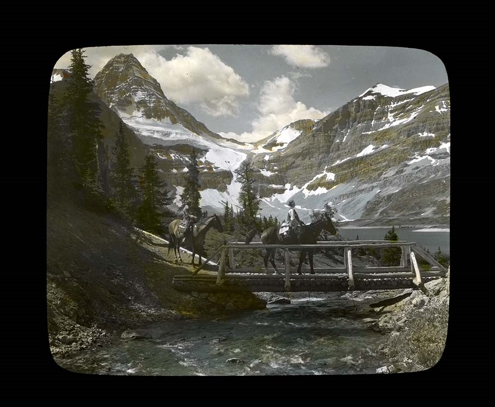
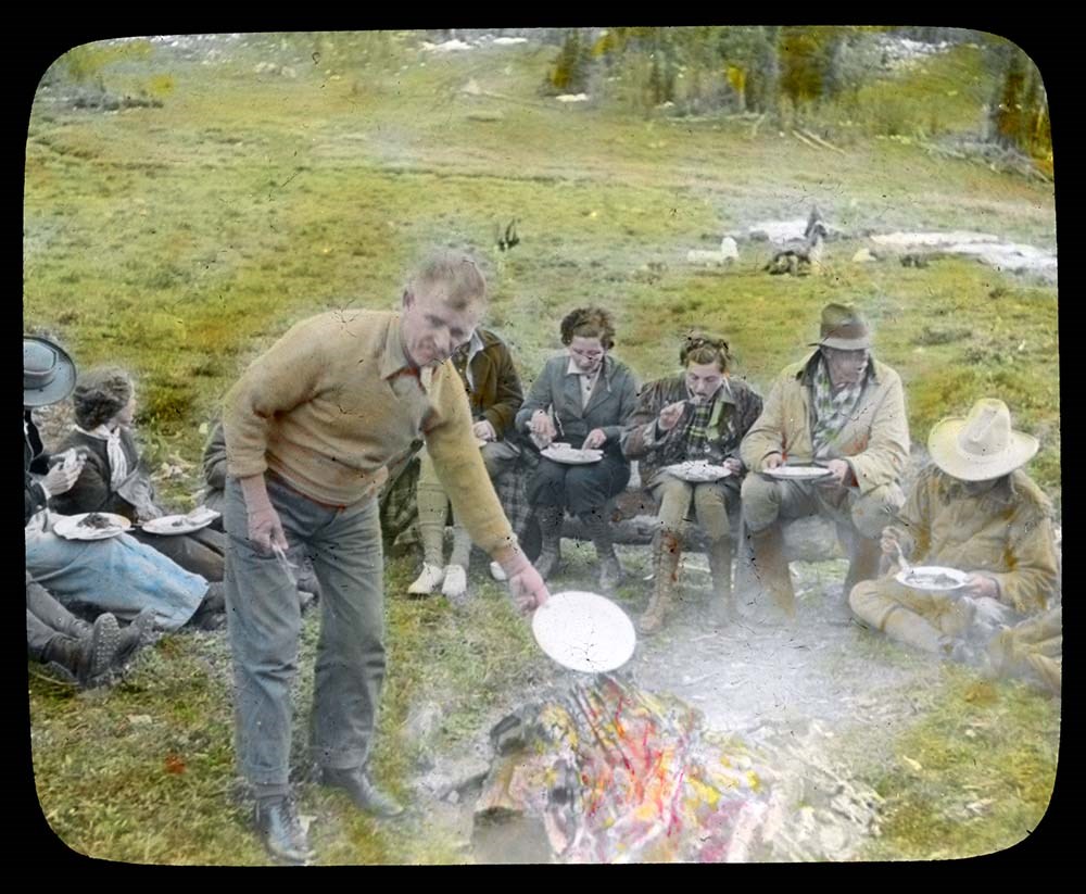
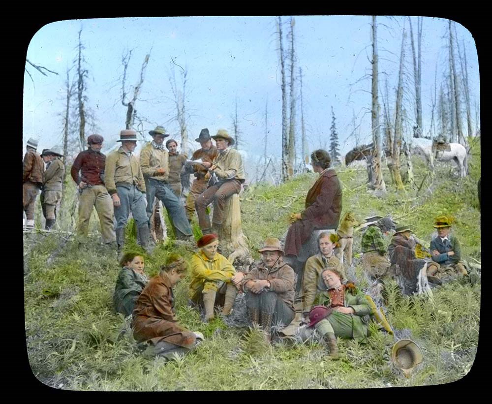
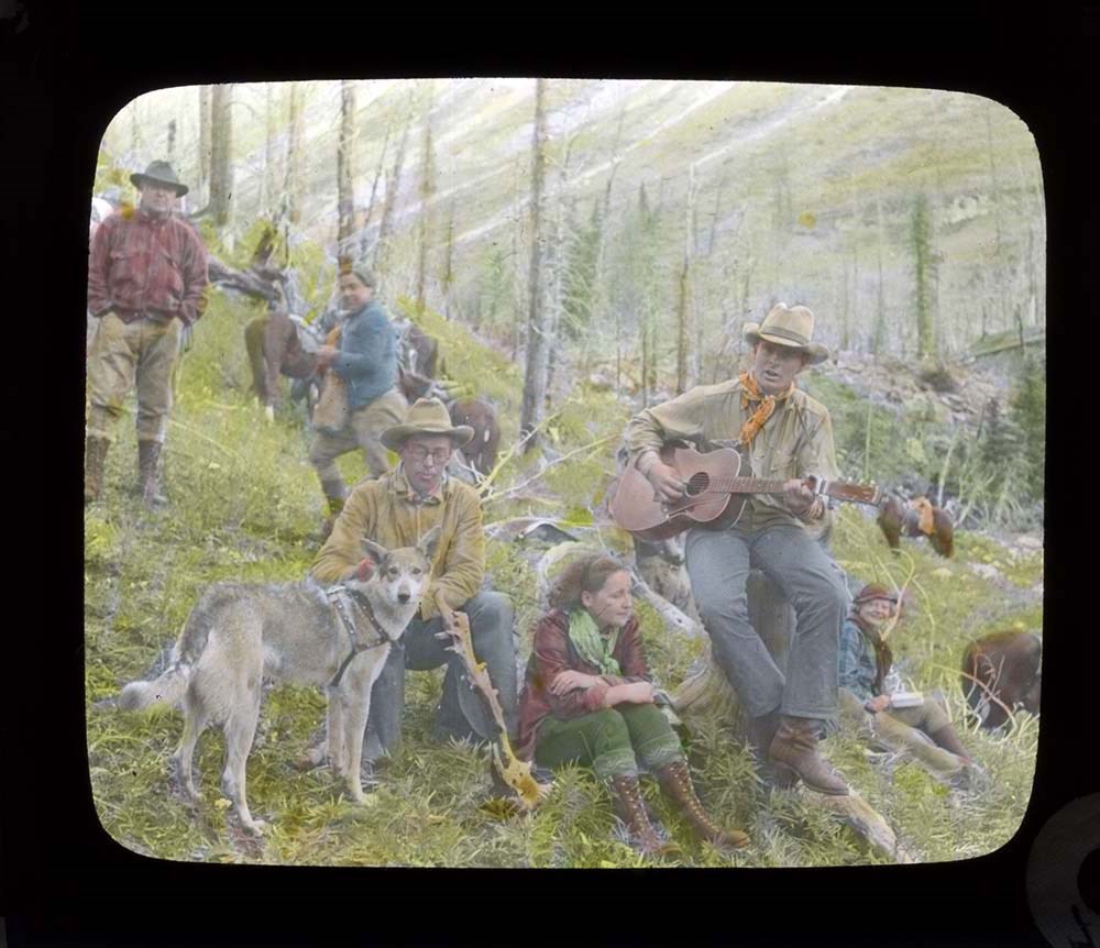
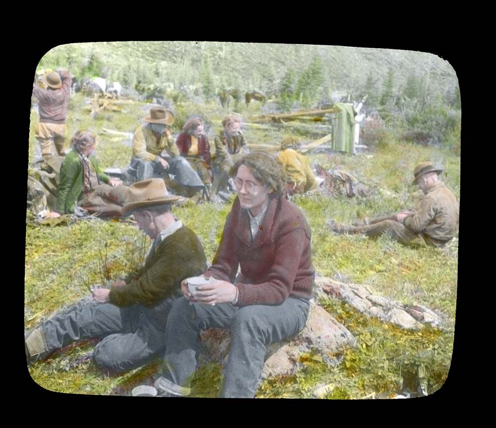
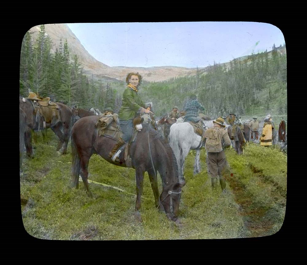
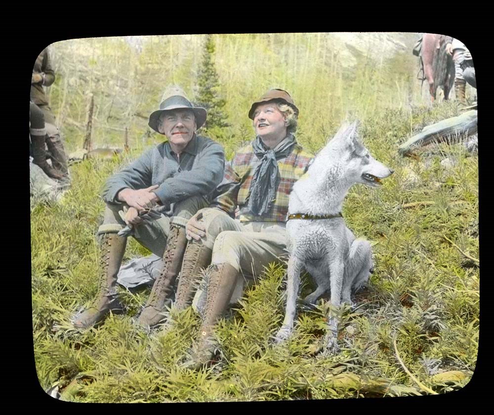
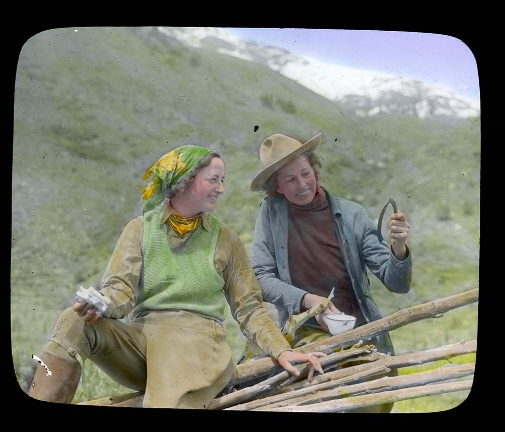
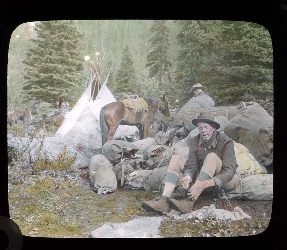
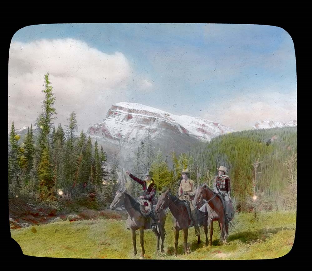
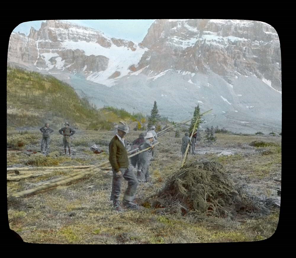
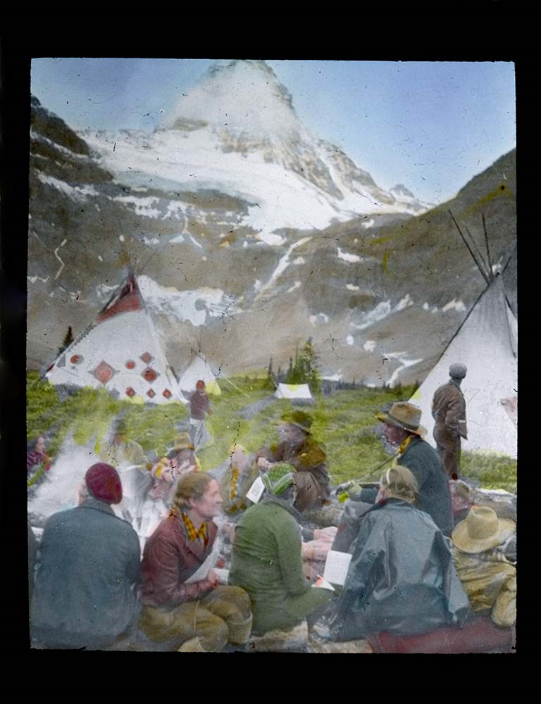
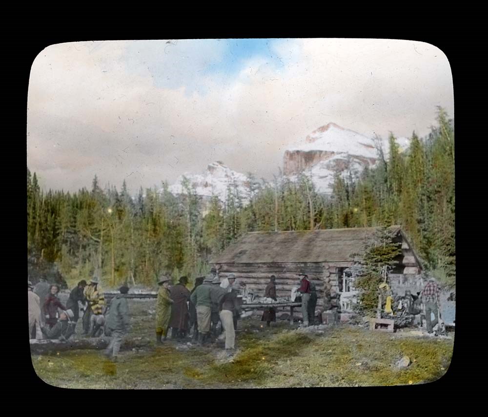
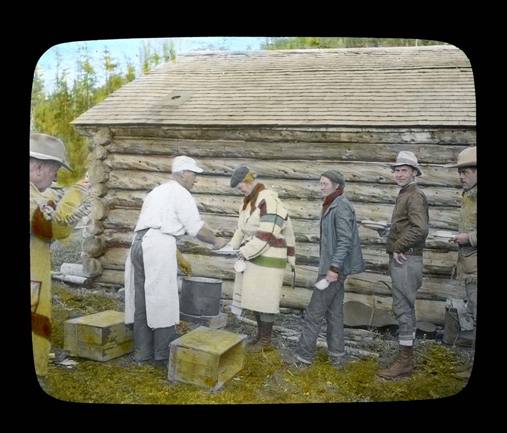
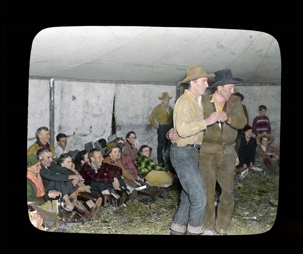
Trail Ride of 1937
https://archives.whyte.org/en/permalink/descriptions54697
- Part Of
- Jean A. Hembroff MacDonald fonds
- Scope & Content
- File consists of 27 colour photograph transparencies (lantern slides). File pertains to the Official Trail Ride of 1937 organized by the Trail Riders of the Canadian Rockies, which Jean Hembroff MacDonald participated in. File documents the trail ride to Mount Assiniboine and the camp at Mount Assi…
- Date Range
- 1937
- Reference Code
- V797 / II / PS - 1 to 27
- Description Level
- 5 / File
- GMD
- Lantern slide
- Photograph
- Transparency
27 images
- Part Of
- Jean A. Hembroff MacDonald fonds
- Description Level
- 5 / File
- Fonds Number
- M573 / V797 / S60
- Series
- V797 / II : Lantern Slides
- Sous-Fonds
- V797
- Accession Number
- 2019.111
- Reference Code
- V797 / II / PS - 1 to 27
- Date Range
- 1937
- Physical Description
- 27 photographs : col. slides
- Scope & Content
- File consists of 27 colour photograph transparencies (lantern slides). File pertains to the Official Trail Ride of 1937 organized by the Trail Riders of the Canadian Rockies, which Jean Hembroff MacDonald participated in. File documents the trail ride to Mount Assiniboine and the camp at Mount Assiniboine, with several landscape photographs but mostly of the hikers.
- Notes
- Jean wrote an article about her experience in the form of an article and a poem [see related material], and used this experience for future lectures.
- Slides are numbered on the back. Some are missing, the new number and order was imposed by Archive and Library Assistant for clarity.
- Slides were stored with a note stating: "Slides taken by the C.P.R. of Trail Ride, 1936-1937."
- Name Access
- Hembroff MacDonald, Jean
- Rungius, Carl
- Fisher, George
- Subject Access
- Trail Riders of the Canadian Rockies
- Hiking
- Mount Assiniboine
- Travel
- Tourism
- Trail guides
- Trails
- Horse packing
- Horseback riding
- Horses
- Geographic Access
- British Columbia
- Alberta
- Great Divide
- Mount Assiniboine
- Mount Assiniboine Park
- Canada
- Canadian Rocky Mountains
- Language
- English
- Related Material
- M573 / I / 18
- Trail Riders of the Canadian Rockies, Bulletin No. 48 (October 1937)
- Title Source
- Title based on contents of file
- Processing Status
- Processed
Images


This material is presented as originally created; it may contain outdated cultural descriptions and
potentially offensive content.
Read more.