Narrow Results By
- Alpine Club of Canada fonds 154
- Nicholas Morant fonds 51
- Ben Gadd fonds 47
- Chic Scott fonds 27
- Trail Riders of the Canadian Rockies fonds 17
- Murray Hay fonds
- Elliott Barnes fonds 13
- Luxton family fonds 13
- Dorothy Wardle fonds 10
- Jean A. Hembroff MacDonald fonds 9
- Henry Vaux Jr. fonds 6
- First ascent and summit note collection 5
Malcolm Geddes fonds
https://archives.whyte.org/en/permalink/descriptions601
- Part Of
- Malcolm Geddes fonds
- Scope & Content
- Fonds consists of textual and visual records pertaining to Malcolm Geddes, as well as his immediate family: wife Jennie (Waters) Geddes, and children Alvin and Enid Geddes; and extended family members. Fonds includes records related to Malcolm's work as a poet and author (including original drafts …
- Date Range
- [1896-2013]
- Reference Code
- M39 / V756
- Description Level
- 1 / Fonds
- GMD
- Photograph
- Negative
- Transparency
- Textual record
- Private record
- Published record
- Part Of
- Malcolm Geddes fonds
- Description Level
- 1 / Fonds
- Fonds Number
- M 39
- V 756
- Sous-Fonds
- M 39
- V 756
- Accession Number
- 5545, 6504, 7846, 2014.8306, 2015.8558
- Reference Code
- M39 / V756
- Responsibility
- Some views are by Malcolm Geddes; many were obtained through other sources
- Date Range
- [1896-2013]
- Physical Description
- 444 photographs: 385 b&w and col. transparencies, 59 b&w prints -- 1 album (28 b&w prints) -- 11 cm of textual records
- History / Biographical
- Malcolm Daniel Geddes, 1866-1927, was a journalist, publisher and mountaineer at Calgary, Alberta, Canada. Geddes was one of the founders of the "Farmers and Ranch Review" in 1904, and served as vice-president and editor until his death. He joined the Alpine Club of Canada in 1917, was active in ACC summer camps and served as Honorary Secretary from 1924 to 1926. Geddes was killed in a mountaineering accident on Mount Lefroy in 1927.
- Scope & Content
- Fonds consists of textual and visual records pertaining to Malcolm Geddes, as well as his immediate family: wife Jennie (Waters) Geddes, and children Alvin and Enid Geddes; and extended family members. Fonds includes records related to Malcolm's work as a poet and author (including original drafts and publications), Malcolm's career in real estate, family letters, financial records, records of mountain ascents and hikes with the Alpine Club of Canada, family trees and genealogical research, and other related materials.
- Notes
- Fonds consists of three series:
- Series I : Professional records I / A : Published materials I / B : Manuscripts and notes I / C : Professional correspondence
- Series II : Financial records
- Series III : Personal and family records III / A : Travel and mountain expeditions III / B : Genealogy and research III / C : Other personal and family records
- Name Access
- Geddes, Malcolm
- Subject Access
- Environment
- Sports, recreation and leisure
- Hiking
- Family and personal life
- Personal and Professional Life
- Poetry
- Property
- Finances
- Commerce and industry
- Communications
- Correspondence
- Genealogy
- History
- Research
- Publication
- Travel
- Mountains
- Mountaineering
- Biography
- Obituary
- Geographic Access
- Canada
- Alberta
- Calgary
- British Columbia
- Ontario
- Canadian Rocky Mountains
- Access Restrictions
- No restrictions on access
- Public domain (other restrictions may apply)
- Reproduction Restrictions
- Restrictions may apply
- Language
- Language is English
- Finding Aid
- Finding aids and reference tools: arrangement outline
- series and file description
- electronic finding aid
- Creator
- Geddes, Malcolm
- Title Source
- Title based on accession records
- Content Details
- Arrangement of fonds was redone by Processing Archivist Kate Skelton between December 2020 and March 2021 to accommodate unprocessed materials from accessions 7846, 2014.8306 and 2015.8558
- Processing Status
- Processed
This material is presented as originally created; it may contain outdated cultural descriptions and
potentially offensive content.
Read more.
Banff National Park (general)
https://archives.whyte.org/en/permalink/descriptions55338
- Part Of
- Murray Hay fonds
- Scope & Content
- File consists of 4 prings : col. 35.1 x 24.8 cm or smaller and 4 maps (2 paper, 2 overlays) : col., on mylar ; 60.4 x 30. cm or smaller. File pertains to aerial views of Banff National Park, showing the towns of Banff and Lake Louise, ski hills (Norqay Ski Hill, Sunshine Village, and Lake Louise Sk…
- Date Range
- ca.1976-ca.2000
- Reference Code
- V795 / II / B / v / 1-2
- Description Level
- 5 / File
- GMD
- Map
- Private record
- Part Of
- Murray Hay fonds
- Description Level
- 5 / File
- Fonds Number
- M570 / V795
- Series
- V795 / II : Unpublished Material
- Sous-Fonds
- V795
- Sub-Series
- V795 / II / B : Alberta / v : Banff National Park
- Accession Number
- 2019.41
- Reference Code
- V795 / II / B / v / 1-2
- GMD
- Map
- Private record
- Date Range
- ca.1976-ca.2000
- Physical Description
- 4 prints : col. 35.1 x 24.8 cm or smaller
- 4 maps (2 paper, 2 overlays) : col., annotations, on mylar ; 60.4 x 30. cm or smaller
- Scope & Content
- File consists of 4 prings : col. 35.1 x 24.8 cm or smaller and 4 maps (2 paper, 2 overlays) : col., on mylar ; 60.4 x 30. cm or smaller. File pertains to aerial views of Banff National Park, showing the towns of Banff and Lake Louise, ski hills (Norqay Ski Hill, Sunshine Village, and Lake Louise Ski Resort), as well as other georgraphic features. The mylar overlays contain various amounts of detail and annotations - one consists of a dark red sheet overlayed with place names in negative.
- Notes
- Items not in oversize stored in downstairs vault.
- Name Access
- Hay, Murray
- Subject Access
- Advertising
- Artist
- Ski Maps
- Map
- Cartography
- Sports and recreation
- Tourism
- Tourist information
- Winter
- Winter sports
- Ski area
- Sunshine Village
- Norquay Ski Hill
- Lake Louise Ski Area
- Geographic Access
- Banff
- Lake Louise
- Banff National Park
- Alberta
- Canada
- Canadian Rocky Mountains
- Language
- English
- Creator
- Hay, Murray
- Title Source
- Title based on contents of file
- Processing Status
- Processed
This material is presented as originally created; it may contain outdated cultural descriptions and
potentially offensive content.
Read more.
Calgary Olympic Bid 1988
https://archives.whyte.org/en/permalink/descriptions54946
- Part Of
- Murray Hay fonds
- Scope & Content
- File consists of 10 prints : col. ; 64 x 61 cm or smaller. File pertains to Murray Hay's participation in Calgary's Olympic Bid in the early 1980s. File includes a variety of different reproduced draft maps depciting Calgary and Canada Olympic Park, Banff National Park, Kananaskis, Spray Valley, et…
- Date Range
- ca.1980-ca.1981
- Reference Code
- V795 / II / B / iv / 1-2
- Description Level
- 5 / File
- GMD
- Map
- Private record
- Part Of
- Murray Hay fonds
- Description Level
- 5 / File
- Fonds Number
- M570 / V795
- Series
- V795 / II : Unpublished Material
- Sous-Fonds
- V795
- Sub-Series
- V795 / II / B : Alberta / iv : Olympic Bid
- Accession Number
- 2019.41
- Reference Code
- V795 / II / B / iv / 1-2
- GMD
- Map
- Private record
- Date Range
- ca.1980-ca.1981
- Physical Description
- 10 prints : col. ; 64 x 61 cm or smaller
- Scope & Content
- File consists of 10 prints : col. ; 64 x 61 cm or smaller. File pertains to Murray Hay's participation in Calgary's Olympic Bid in the early 1980s. File includes a variety of different reproduced draft maps depciting Calgary and Canada Olympic Park, Banff National Park, Kananaskis, Spray Valley, etc.
- Notes
- Date range is approximate. The Olympic Bid was selected in 1981.
- One print depicting the City of Calgary with the Canadian Rockies in the background has a note taped to it that reads: "A view from Calgary to Banff showing Olympic sites for 1988 winter games (proximity exaggerated."
- Name Access
- Hay, Murray
- Subject Access
- Artist
- Ski Maps
- Map
- Cartography
- Sports and recreation
- Tourism
- Winter
- Winter sports
- Olympic Games (Winter)
- Geographic Access
- Calgary
- Banff National Park
- Alberta
- Canada
- Canadian Rocky Mountains
- Canada Olympic Park
- Spray Lakes
- Spray Valley
- Bow Valley
- Kananaskis
- Bragg Creek
- Canmore
- Language
- English
- Conservation
- V795 / II / B / iv / 2 : Masking tape should be removed and alternative preservation methods should be considered at a reasonable time to do so.
- Related Material
- M570 / III / C / i / 1
- Creator
- Hay, Murray
- Title Source
- Title based on contents of file
- Processing Status
- Processed
This material is presented as originally created; it may contain outdated cultural descriptions and
potentially offensive content.
Read more.
Canadian Rockies
https://archives.whyte.org/en/permalink/descriptions54817
- Part Of
- Murray Hay fonds
- Scope & Content
- File consists of 1 cm of textual records, 10 x 22 cm. File pertains to tourist maps of the Canadian Rocky Mountains created by Murray Hay. File includes a brochure of titled "Canadian Rockies Access Maps" that, when unfolded, includes several maps of the various areas that make up the Canadian Rock…
- Date Range
- ca. 1990 - 1999
- 1999
- Reference Code
- M570 / III / D / i / 2
- Description Level
- 5 / File
- GMD
- Published record
- Map
- Textual record
- Part Of
- Murray Hay fonds
- Description Level
- 5 / File
- Fonds Number
- M570 / V795
- Series
- M570 / III : Murray Hay portfolio (published material)
- Sous-Fonds
- M570
- Sub-Series
- M570 / III / D : Miscellaneous / i : Canada (general)
- Accession Number
- 2019.41
- Reference Code
- M570 / III / D / i / 2
- Date Range
- ca. 1990 - 1999
- 1999
- Physical Description
- 1 cm of textual records (10 x 22 cm)
- Scope & Content
- File consists of 1 cm of textual records, 10 x 22 cm. File pertains to tourist maps of the Canadian Rocky Mountains created by Murray Hay. File includes a brochure of titled "Canadian Rockies Access Maps" that, when unfolded, includes several maps of the various areas that make up the Canadian Rocky Mountains, like Kananaskis Country, Canmore, Banff National Park, Jasper National Park, Yoho National Park, etc.
- Name Access
- Hay, Murray
- Subject Access
- Advertising
- Artist
- Banff
- Banff National Park
- Cartography
- Communications
- Lake Louise
- Kananaskis Country
- Map
- Mountains
- Tourism
- Tourist information
- Travel
- Geographic Access
- Canada
- Canadian Rocky Mountains
- Alberta
- British Columbia
- Yoho National Park
- Jasper National Park
- Banff National Park
- Glacier National Park
- Canmore
- Banff
- Jasper
- Lake Louise
- Kananaskis
- Kananaskis Country
- Kootenay National Park
- Language
- English
- Title Source
- Title based on contents of file
- Processing Status
- Processed
This material is presented as originally created; it may contain outdated cultural descriptions and
potentially offensive content.
Read more.
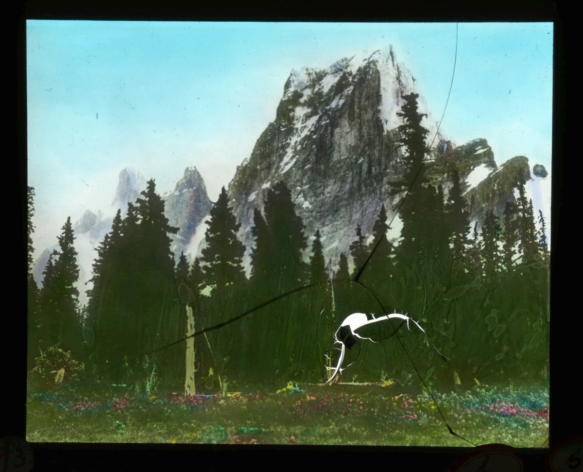
Canadian Rockies mountaineering trips, Alpine Club of Canada expeditions
https://archives.whyte.org/en/permalink/descriptions55242
- Part Of
- Malcolm Geddes fonds
- Scope & Content
- File consists of 129 lantern slides pertaining to mountaineering expeditions and scenic views in the Canadian Rockies. Includes images of pack trips, ice climbing, hiking, and Alpine Club of Canada camps. Locations include Emperor Falls; Berg Lake; ascent of Resplendent Mountain; Mount Edith Cavell…
- Date Range
- [1913-1925]
- Reference Code
- V756 / III / A / PS - 1 to 129
- Description Level
- 5 / File
- GMD
- Photograph
- Lantern slide
1 image
- Part Of
- Malcolm Geddes fonds
- Description Level
- 5 / File
- Fonds Number
- M39
- V756
- Series
- V756 / III : Personal and family records
- Sous-Fonds
- V756
- Sub-Series
- V756 / III / A : Travel and mountain expeditions
- Accession Number
- 6504
- Reference Code
- V756 / III / A / PS - 1 to 129
- Responsibility
- Some items produced by Charles Potter and James Mahon
- Date Range
- [1913-1925]
- Physical Description
- 129 photographs : lantern slides
- Scope & Content
- File consists of 129 lantern slides pertaining to mountaineering expeditions and scenic views in the Canadian Rockies. Includes images of pack trips, ice climbing, hiking, and Alpine Club of Canada camps. Locations include Emperor Falls; Berg Lake; ascent of Resplendent Mountain; Mount Edith Cavell; Mount Maud; Mount Commander; Mount Marpole; Mount Habel; Mount Robson; Mount Temple; Mount Huber; Castle Mountain; and Wilcox Pass.
- Notes
- Some items are numbered on outer edges or otherwise labelled
- Material Details
- Some items hand-coloured
- Name Access
- Gibbon, John Murray
- Wheeler, A. O. (Arthur Oliver)
- Geddes, Malcolm
- Alpine Club of Canada
- Subject Access
- Travel
- Exploration
- Hiking
- Ice climbing
- Summit
- Mountains
- Landscapes
- Recreation
- Alpine Club of Canada
- Glaciers
- Trails
- Pack trips
- Camping
- Geographic Access
- Canada
- Alberta
- British Columbia
- Canadian Rocky Mountains
- Mount Robson
- Mount Temple
- Mount Habel
- Mount Geikie
- Mount Huber
- Castle Mountain
- Wilcox Pass
- Mount Edith Cavell
- Mount Maud
- Mount Commander
- Mount Marpole
- Access Restrictions
- Fragile - restrictions may apply
- Reproduction Restrictions
- Fragile- restrictions may apply
- Language
- N/A
- Title Source
- Title based on contents of file
- Processing Status
- Processed
Images
This material is presented as originally created; it may contain outdated cultural descriptions and
potentially offensive content.
Read more.
Drafts, edited copies
https://archives.whyte.org/en/permalink/descriptions55248
- Part Of
- Malcolm Geddes fonds
- Scope & Content
- File consists of handwritten and typed drafts of works by Malcolm Geddes. Content pertains to the first ascent of Mount Geikie, mountaineering and mountain climbing, and life in Western Canada and Parry Sound, Ontario. Includes three typed drafts of "Beyond the Eagle's Nest" with edits and correcti…
- Date Range
- [1890-1900]
- [1900-1920]
- [1925-1927]
- Reference Code
- M39 / I / B / 2
- Description Level
- 5 / File
- GMD
- Textual record
- Part Of
- Malcolm Geddes fonds
- Description Level
- 5 / File
- Fonds Number
- M39
- V756
- Series
- M39 / I : Professional records
- Sous-Fonds
- M39
- Sub-Series
- M39 / I / B : Manuscripts and drafts
- Accession Number
- 7846
- Reference Code
- M39 / I / B / 2
- GMD
- Textual record
- Date Range
- [1890-1900]
- [1900-1920]
- [1925-1927]
- Physical Description
- 2 cm of textual records
- Scope & Content
- File consists of handwritten and typed drafts of works by Malcolm Geddes. Content pertains to the first ascent of Mount Geikie, mountaineering and mountain climbing, and life in Western Canada and Parry Sound, Ontario. Includes three typed drafts of "Beyond the Eagle's Nest" with edits and corrections.
- Name Access
- Geddes, Malcolm
- Subject Access
- Mountains
- Mountaineering
- Exploration
- Travel
- Family and personal life
- Summit
- Settlement
- Geographic Access
- Canada
- British Columbia
- Mount Geikie
- Canadian Rocky Mountains
- Ontario
- Parry Sound
- Reproduction Restrictions
- Restrictions may apply
- Language
- English
- Category
- Exploration, discovery and travel
- Family and personal life
- Land, settlement and immigration
- Title Source
- Title based on contents of file
- Processing Status
- Processed
This material is presented as originally created; it may contain outdated cultural descriptions and
potentially offensive content.
Read more.
Fernie Alpine Resort
https://archives.whyte.org/en/permalink/descriptions54883
- Part Of
- Murray Hay fonds
- Scope & Content
- File consists of 2 maps (1 base, 4 overlays) : col., annotations, on mylar ; 32 x 27 cm and 30 x 22 cm, and 2 prints : col. ; 35 x 28 cm. File pertains to Murray Hay's rendering of the ski hill at Fernie, British Columbia. File includes two reproduced drafts with mylar overlays (one held together b…
- Date Range
- ca.1977-ca.1997
- Reference Code
- V795 / II / A / vi / 1-2
- Description Level
- 5 / File
- GMD
- Map
- Private record
- Part Of
- Murray Hay fonds
- Description Level
- 5 / File
- Fonds Number
- M570 / V795
- Series
- V795 / II : Unpublished Material
- Sous-Fonds
- V795
- Sub-Series
- V795 / II / A : British Columbia / vi : Fernie
- Accession Number
- 2019.41
- Reference Code
- V795 / II / A / vi / 1-2
- GMD
- Map
- Private record
- Date Range
- ca.1977-ca.1997
- Physical Description
- 2 maps (1 base, 4 overlays) : col., annotations, on mylar ; 32 x 27 cm and 30 x 22 cm
- 2 prints : col. ; 35 x 28 cm
- Scope & Content
- File consists of 2 maps (1 base, 4 overlays) : col., annotations, on mylar ; 32 x 27 cm and 30 x 22 cm, and 2 prints : col. ; 35 x 28 cm. File pertains to Murray Hay's rendering of the ski hill at Fernie, British Columbia. File includes two reproduced drafts with mylar overlays (one held together by tape or glue, the other by masking tape), and two reproduced draft prints of the ski area.
- Notes
- Date range is approximate. The Timberland sub-division was developed between 1981-1991. The resort was known as Fernie Snow Valley until 1997.
- Name Access
- Hay, Murray
- Subject Access
- Advertising
- Art
- Artist
- Ski Maps
- Cartography
- Sports and recreation
- Tourism
- Tourist information
- Winter
- Winter sports
- Ski area
- Geographic Access
- Fernie
- British Columbia
- Canada
- Canadian Rocky Mountains
- Language
- English
- Conservation
- Masking tape should be removed and alternative preservation methods should be considered at a reasonable time to do so.
- Creator
- Hay, Murray
- Title Source
- Title based on contents of file
- Processing Status
- Processed
This material is presented as originally created; it may contain outdated cultural descriptions and
potentially offensive content.
Read more.
Invermere Area
https://archives.whyte.org/en/permalink/descriptions54889
- Part Of
- Murray Hay fonds
- Scope & Content
- File consists of 1 map (1 base, 1 overlay) : ms., col., annotations, on tracing paper. File pertains to Murray Hay's rendering of the Invermere area (including the town, key local areas, and Radium). File includes one original painting on a piece of white board.
- Date Range
- ca.1980-ca.1989
- Reference Code
- V795 / II / A / vii / 2
- Description Level
- 5 / File
- GMD
- Map
- Painting
- Part Of
- Murray Hay fonds
- Description Level
- 5 / File
- Fonds Number
- M570 / V795
- Series
- V795 / II : Unpublished Material
- Sous-Fonds
- V795
- Sub-Series
- V795 / II / A : British Columbia / vii : Invermere
- Accession Number
- 2020.03
- Reference Code
- V795 / II / A / vii / 2
- Date Range
- ca.1980-ca.1989
- Physical Description
- 1 map (1 base, 1 overlay) : ms., col., annotations, on tracing paper
- Scope & Content
- File consists of 1 map (1 base, 1 overlay) : ms., col., annotations, on tracing paper. File pertains to Murray Hay's rendering of the Invermere area (including the town, key local areas, and Radium). File includes one original painting on a piece of white board.
- Notes
- Copyright Key West Publishers on the bottom right corner.
- Name Access
- Hay, Murray
- Subject Access
- Advertising
- Art
- Artist
- Painting
- Tourism
- Tourist information
- Travel
- Map
- Cartography
- Geographic Access
- British Columbia
- Canada
- Canadian Rocky Mountains
- Invermere
- Language
- English
- Creator
- Hay, Murray
- Title Source
- Title based on contents of file
- Processing Status
- Processed
This material is presented as originally created; it may contain outdated cultural descriptions and
potentially offensive content.
Read more.
Jasper Marmot Basin
https://archives.whyte.org/en/permalink/descriptions54813
- Part Of
- Murray Hay fonds
- Scope & Content
- File consists of 1 cm of textual records, 10 x 23.5 cm or smaller. File pertains to ski trail maps of Jasper Marmot Basin and ski area created by Murray Hay. File includes three brochures promoting the ski runs at Marmot Basin that each include a reproduced map by Hay.
- Date Range
- 2001-2003
- 2001
- 2003
- Reference Code
- M570 / III / B / iii / 1
- Description Level
- 5 / File
- GMD
- Map
- Textual record
- Published record
- Part Of
- Murray Hay fonds
- Description Level
- 5 / File
- Fonds Number
- M570 / V795
- Series
- M570 / III : Murray Hay portfolio (published material)
- Sous-Fonds
- M570
- Sub-Series
- M570 / III / B : Alberta / iii : Jasper
- Accession Number
- 2019.41
- Reference Code
- M570 / III / B / iii / 1
- Date Range
- 2001-2003
- 2001
- 2003
- Physical Description
- 1 cm of textual records (10 x 23.5 cm or smaller)
- Scope & Content
- File consists of 1 cm of textual records, 10 x 23.5 cm or smaller. File pertains to ski trail maps of Jasper Marmot Basin and ski area created by Murray Hay. File includes three brochures promoting the ski runs at Marmot Basin that each include a reproduced map by Hay.
- Name Access
- Hay, Murray
- Subject Access
- Ski Maps
- Skiing
- Ski areas
- Map
- Marmot Basin Ski Area
- Cartography
- Sports and recreation
- Tourism
- Tourist information
- Travel
- Winter
- Winter sports
- Advertising
- Artist
- Geographic Access
- Jasper
- Jasper Marmot Basin
- Jasper National Park
- Alberta
- Canada
- Canadian Rocky Mountains
- Language
- English
- Related Material
- V795 / II / B / i / 1
- Title Source
- Title based on contents of file
- Processing Status
- Processed
This material is presented as originally created; it may contain outdated cultural descriptions and
potentially offensive content.
Read more.
- Part Of
- Murray Hay fonds
- Scope & Content
- File consists of 1.5 cm of textual records, 53 x 80.5 cm and 10 x 23.5 cm. File pertains to ski trail maps of Lake Louise ski area created by Murray Hay. File includes two published reproductions of three original trail maps in a fold-out brochure (1992/1993) and in poster format. The three maps de…
- Date Range
- ca.1980 - ca. 1995
- 1992-1993
- Reference Code
- M570 / III / B / ii / 1-2
- Description Level
- 5 / File
- GMD
- Textual record
- Published record
- Map
- Poster
- Part Of
- Murray Hay fonds
- Description Level
- 5 / File
- Fonds Number
- M570 / V795
- Series
- M570 / III : Murray Hay portfolio (published material)
- Sous-Fonds
- M570
- Sub-Series
- M570 / III / B : Alberta / ii : Lake Louise
- Accession Number
- 2019.41
- Reference Code
- M570 / III / B / ii / 1-2
- Date Range
- ca.1980 - ca. 1995
- 1992-1993
- Physical Description
- 1.5 cm of textual records (53 x 80.5 cm and 10 x 23.5 cm)
- Scope & Content
- File consists of 1.5 cm of textual records, 53 x 80.5 cm and 10 x 23.5 cm. File pertains to ski trail maps of Lake Louise ski area created by Murray Hay. File includes two published reproductions of three original trail maps in a fold-out brochure (1992/1993) and in poster format. The three maps depict South Face, Back Bowls, and Larch Area.
- Name Access
- Hay, Murray
- Subject Access
- Ski area
- Ski Maps
- Skiing
- Tourism
- Cartography
- Map
- Winter
- Winter sports
- Sports and recreation
- Travel
- Lake Louise Ski Area
- Lake Louise
- Artist
- Advertising
- Geographic Access
- Lake Louise
- Alberta
- Canada
- Canadian Rocky Mountains
- Language
- English
- Related Material
- V795 / II / B / ii / 1
- Title Source
- Title based on contents of file
- Processing Status
- Processed
This material is presented as originally created; it may contain outdated cultural descriptions and
potentially offensive content.
Read more.
Lake Louise Area
https://archives.whyte.org/en/permalink/descriptions54925
- Part Of
- Murray Hay fonds
- Scope & Content
- File consists of 6 prints : col. ; 25.5 x 20 cm or smaller. File pertains to Murray Hay's renderings of the Lake Louise ski area. File includes six reproduced draft prints of original paintings of the Lake Louise ski area created by Murray Hay (different iterations).
- Date Range
- ca.1976-ca.2000
- Reference Code
- V795 / II / B / ii / 1
- Description Level
- 5 / File
- GMD
- Map
- Private record
- Part Of
- Murray Hay fonds
- Description Level
- 5 / File
- Fonds Number
- M570 / V795
- Series
- V795 / I : Unpublished Material
- Sous-Fonds
- V795
- Sub-Series
- V795 / I / B : Alberta / ii : Lake Louise
- Accession Number
- 2019.41
- Reference Code
- V795 / II / B / ii / 1
- GMD
- Map
- Private record
- Date Range
- ca.1976-ca.2000
- Physical Description
- 6 prints : col. ; 25.5 x 20 cm or smaller
- Scope & Content
- File consists of 6 prints : col. ; 25.5 x 20 cm or smaller. File pertains to Murray Hay's renderings of the Lake Louise ski area. File includes six reproduced draft prints of original paintings of the Lake Louise ski area created by Murray Hay (different iterations).
- Name Access
- Hay, Murray
- Subject Access
- Advertising
- Artist
- Ski Maps
- Map
- Cartography
- Sports and recreation
- Tourism
- Tourist information
- Winter
- Winter sports
- Ski area
- Lake Louise Ski Area
- Geographic Access
- Lake Louise
- Alberta
- Canada
- Canadian Rocky Mountains
- Language
- English
- Related Material
- M570 / III / B / ii / 1-2
- Creator
- Hay, Murray
- Title Source
- Title based on contents of file
- Processing Status
- Processed
This material is presented as originally created; it may contain outdated cultural descriptions and
potentially offensive content.
Read more.
Lake O'Hara Trails
https://archives.whyte.org/en/permalink/descriptions54776
- Part Of
- Murray Hay fonds
- Scope & Content
- File consists of 0.5 cm of textual records, 60.5 x 48.5 cm. File pertains to a trail map of the Lake O'Hara area created by Murray Hay. File consists of one published poster depicting a reproduced map of the trails at Lake O'Hara in Yoho National Park (British Columbia).
- Date Range
- ca.1970-ca.2015
- Reference Code
- M570 / III / A / iv / 1
- Description Level
- 5 / File
- GMD
- Map
- Poster
- Published record
- Textual record
- Part Of
- Murray Hay fonds
- Description Level
- 5 / File
- Fonds Number
- M570 / V795
- Series
- M570 / III : Murray Hay Portfolio (published material)
- Sous-Fonds
- M570
- Sub-Series
- M570 / III / A : British Columbia / iv : Lake O'Hara
- Accession Number
- 2019.41
- Reference Code
- M570 / III / A / iv / 1
- Date Range
- ca.1970-ca.2015
- Physical Description
- 0.5 cm of textual material (60.5 x 48.5 cm)
- Scope & Content
- File consists of 0.5 cm of textual records, 60.5 x 48.5 cm. File pertains to a trail map of the Lake O'Hara area created by Murray Hay. File consists of one published poster depicting a reproduced map of the trails at Lake O'Hara in Yoho National Park (British Columbia).
- Notes
- M570 / III / A / iv / 1 is oversize.
- Name Access
- Hay, Murray
- Subject Access
- Trails
- Hiking
- Cartography
- Advertising
- Artist
- Sports and recreation
- Travel
- Tourism
- Tourist information
- Geographic Access
- Lake O'Hara
- British Columbia
- Canada
- Canadian Rocky Mountains
- Yoho National Park
- Language
- English
- Title Source
- Title based on contents of file
- Processing Status
- Processed
This material is presented as originally created; it may contain outdated cultural descriptions and
potentially offensive content.
Read more.
- Part Of
- Murray Hay fonds
- Scope & Content
- File consists of 2 prints : col. ; 35 x 28 cm. File pertains to Murray Hay's rendering of Marmot Basin ski area in Jasper National Park. File includes two iterations of reproduction draft prints of Hay's map of Marmot Basin.
- Date Range
- ca.1976-ca.2000
- Reference Code
- V795 / II / B / i / 1
- Description Level
- 5 / File
- GMD
- Map
- Private record
- Part Of
- Murray Hay fonds
- Description Level
- 5 / File
- Fonds Number
- M570 / V795
- Series
- V795 / II : Unpublished Material
- Sous-Fonds
- V795
- Sub-Series
- V795 / II / B : Alberta / i : Jasper National Park
- Accession Number
- 2019.41
- Reference Code
- V795 / II / B / i / 1
- GMD
- Map
- Private record
- Date Range
- ca.1976-ca.2000
- Physical Description
- 2 prints : col. ; 35 x 28 cm
- Scope & Content
- File consists of 2 prints : col. ; 35 x 28 cm. File pertains to Murray Hay's rendering of Marmot Basin ski area in Jasper National Park. File includes two iterations of reproduction draft prints of Hay's map of Marmot Basin.
- Name Access
- Hay, Murray
- Subject Access
- Advertising
- Artist
- Ski Maps
- Ski area
- Map
- Cartography
- Sports and recreation
- Tourism
- Tourist information
- Winter
- Winter sports
- Geographic Access
- Jasper Marmot Basin
- Jasper National Park
- Alberta
- Canada
- Canadian Rocky Mountains
- Language
- English
- Related Material
- M570 / III / B / iii / 1
- Creator
- Hay, Murray
- Title Source
- Title based on contents of file
- Processing Status
- Processed
This material is presented as originally created; it may contain outdated cultural descriptions and
potentially offensive content.
Read more.
National Parks - Kootenay, Yoho, Glacier, Jasper, Waterton Lakes
https://archives.whyte.org/en/permalink/descriptions55243
- Part Of
- Malcolm Geddes fonds
- Scope & Content
- File consists of 70 lantern slide images pertaining to views from Kootenay, Yoho, Glacier, Jasper and Waterton Lakes National Parks. Specific locations include: Marble Canyon and Sinclair Canyon; Mount Stephen, Lake Oesa, Lake O'Hara, Lake McArthur, Takakkaw Falls, Twin Falls and Yoho Glacier; Ille…
- Date Range
- [ca.1925]
- Reference Code
- V756 / III / A / PS - 161 to 230
- Description Level
- 5 / File
- GMD
- Photograph
- Lantern slide
- Part Of
- Malcolm Geddes fonds
- Description Level
- 5 / File
- Fonds Number
- M39
- V756
- Series
- V756 / III : Personal and family records
- Sous-Fonds
- V756
- Sub-Series
- V756 / III / A : Travel and mountain expeditions
- Accession Number
- 6504
- Reference Code
- V756 / III / A / PS - 161 to 230
- Responsibility
- Some items issued by Department of the Interior Natural Resources Intelligence Branch and by Canadian National Railways
- Date Range
- [ca.1925]
- Physical Description
- 70 photographs : lantern slides
- Scope & Content
- File consists of 70 lantern slide images pertaining to views from Kootenay, Yoho, Glacier, Jasper and Waterton Lakes National Parks. Specific locations include: Marble Canyon and Sinclair Canyon; Mount Stephen, Lake Oesa, Lake O'Hara, Lake McArthur, Takakkaw Falls, Twin Falls and Yoho Glacier; Illecillewaet Glacier and surrounding area; Jasper town and Jasper Park Lodge; Maligne Lake, Maligne Canyon, Mount Edith Cavell and Mount Robson; and Waterton Lake area. Most items are captioned.
- Notes
- Slides are organized by location: V756 / III / A / PS - 161 to 167 : Kootenay V756 / III / A / PS - 168 to 185 : Yoho V756 / III / A / PS - 186 to 194 : Glacier V756 / III / A / PS - 195 to 226 : Jasper V756 / III / A / PS - 227 to 230 : Waterton Lakes
- Subject Access
- Travel
- Exploration
- Mountains
- Landscapes
- Glaciers
- Hotels
- Waterfalls
- National parks and reserves
- Tourism
- Recreation
- Geographic Access
- Canada
- Alberta
- British Columbia
- Canadian Rocky Mountains
- Kootenay National Park
- Yoho National Park
- Glacier National Park
- Jasper National Park
- Jasper
- Waterton Lakes National Park
- Waterton
- Access Restrictions
- Fragile - restrictions may apply
- Language
- English
- Title Source
- Title based on contents of file
- Processing Status
- Processed
This material is presented as originally created; it may contain outdated cultural descriptions and
potentially offensive content.
Read more.
Newspaper Clippings
https://archives.whyte.org/en/permalink/descriptions54745
- Part Of
- Murray Hay fonds
- Scope & Content
- File consists of 1 cm of textual material in the form of newspaper clippings, 32 x 60 cm or smaller. File pertains to the career of Murray Hay as a ski map artist. File documents Hay's wide-ranging success creating trail maps for ski resorts, particularly in Alberta and British Columbia, Canada (al…
- Date Range
- 1991
- 1993
- 1996
- 1998
- Reference Code
- M570 / I / 1
- Description Level
- 5 / File
- GMD
- Published record
- Textual record
- Newspaper clipping
- Part Of
- Murray Hay fonds
- Description Level
- 5 / File
- Fonds Number
- M570 / V795
- Series
- M570 / I : Newspaper Clippings
- Sous-Fonds
- M570
- Accession Number
- 2019.41
- Reference Code
- M570 / I / 1
- Date Range
- 1991
- 1993
- 1996
- 1998
- Physical Description
- 1 cm of textual records (32 x 60 cm or smaller)
- Scope & Content
- File consists of 1 cm of textual material in the form of newspaper clippings, 32 x 60 cm or smaller. File pertains to the career of Murray Hay as a ski map artist. File documents Hay's wide-ranging success creating trail maps for ski resorts, particularly in Alberta and British Columbia, Canada (although he made maps for ski resorts and other organizations internationally, particularly in the United States). File also includes interviews with Hay about his mapmaking process and style, successes, challenges (including the impact of technology on his work).
- 2020-02-14
- Notes
- Includes articles that were published in the Calgary Sun (January 17, 1991) and the Calgary Herald (March 11, 1993; March 2, 1996; April 16, 1998).
- Name Access
- Hay, Murray
- Subject Access
- Ski areas
- Skiing
- Sports and recreation
- Art
- Artist
- Map
- Ski Maps
- Activities
- Banff National Park
- Cartography
- Lake Louise Ski Area
- Landscapes
- Professional and Personal Life
- Winter
- Winter sports
- Whistler Blackcomb
- Newspaper
- Calgary Herald
- Calgary Sun
- Geographic Access
- Canada
- Canadian Rocky Mountains
- Alberta
- Banff National Park
- Jasper National Park
- British Columbia
- Calgary
- Language
- English
- Title Source
- Title based on contents of file
- Processing Status
- Processed
This material is presented as originally created; it may contain outdated cultural descriptions and
potentially offensive content.
Read more.
- Part Of
- Malcolm Geddes fonds
- Scope & Content
- File consists of original poetry drafts written by Malcolm Geddes. Content pertains to landscapes and trails in the Canadian Rockies, love and romance, and various other subjects related to Malcolm's life.
- Date Range
- 1896
- 1901-1902
- [1900-1920]
- 1926
- Reference Code
- M39 / I / B / 1
- Description Level
- 5 / File
- GMD
- Textual record
- Part Of
- Malcolm Geddes fonds
- Description Level
- 5 / File
- Fonds Number
- M39
- V756
- Series
- M39 / I : Professional records
- Sous-Fonds
- M39
- Sub-Series
- M39 / I / B : Manuscripts and notes
- Accession Number
- 7846
- Reference Code
- M39 / I / B / 1
- GMD
- Textual record
- Date Range
- 1896
- 1901-1902
- [1900-1920]
- 1926
- Physical Description
- 0.5 cm of textual records
- Scope & Content
- File consists of original poetry drafts written by Malcolm Geddes. Content pertains to landscapes and trails in the Canadian Rockies, love and romance, and various other subjects related to Malcolm's life.
- Notes
- Most items are not dated
- Subject Access
- Family and personal life
- Mountains
- Environment and Nature
- Exploration
- Trails
- Geographic Access
- Canada
- Alberta
- Canadian Rocky Mountains
- Reproduction Restrictions
- Some restrictions may apply
- Language
- English
- Title Source
- Title based on contents of file
- Processing Status
- Processed
This material is presented as originally created; it may contain outdated cultural descriptions and
potentially offensive content.
Read more.
Sunshine Ski Area
https://archives.whyte.org/en/permalink/descriptions54780
- Part Of
- Murray Hay fonds
- Scope & Content
- File consists of 1.5 cm of textual records, 58 x 72.5 cm and 21.5 x 27.5 cm. File pertains to ski trail maps of Sunshine Ski Area created by Murray Hay. File includes two published reproductions of original trail maps in poster format made by Hay for the Husky World Downhill and Giant Slalom on Mar…
- Date Range
- ca.1985-1986
- 1986
- Reference Code
- M570 / III / B / i / 1-2
- Description Level
- 5 / File
- GMD
- Map
- Poster
- Textual record
- Published record
- Part Of
- Murray Hay fonds
- Description Level
- 5 / File
- Fonds Number
- M570 / V795
- Series
- M570 / III : Murray Hay Portfolio (published material)
- Sous-Fonds
- M570
- Sub-Series
- M570 / III / B : Alberta / i : Sunshine
- Accession Number
- 2019.41
- Reference Code
- M570 / III / B / i / 1-2
- Date Range
- ca.1985-1986
- 1986
- Physical Description
- 1.5 cm of textual records (58 x 72.5 cm and 21.5 x 27.5 cm)
- Scope & Content
- File consists of 1.5 cm of textual records, 58 x 72.5 cm and 21.5 x 27.5 cm. File pertains to ski trail maps of Sunshine Ski Area created by Murray Hay. File includes two published reproductions of original trail maps in poster format made by Hay for the Husky World Downhill and Giant Slalom on March 8-9, 1986.
- Notes
- M570 / III / B / i / 2 is oversize.
- Name Access
- Hay, Murray
- Subject Access
- Skiing
- Ski Maps
- Ski area
- Tourism
- Cartography
- Map
- Winter
- Winter sports
- Travel
- Sunshine Village
- Sunshine Ski Resort
- Sunshine area
- Sports and recreation
- Artist
- Advertising
- Geographic Access
- Banff National Park
- Alberta
- Canada
- Canadian Rocky Mountains
- Language
- English
- Related Material
- V795 / II / B / vi / 1-3
- Title Source
- Title based on contents of file
- Processing Status
- Processed
This material is presented as originally created; it may contain outdated cultural descriptions and
potentially offensive content.
Read more.
Sunshine Village
https://archives.whyte.org/en/permalink/descriptions54991
- Part Of
- Murray Hay fonds
- Scope & Content
- File consists of 9 prints : b&w and col. ; 35 x 28 cm or smaller, 2 maps (1 base, 4 overlays) : col., annotations, on mylar ; 26 x 35 cm and 23.5 x 31.5 cm, and 1 painting : landscape ; 46 x 43 cm. File pertains to ski trail maps and landscape maps/prints of Sunshine ski area created by Murray Hay.…
- Date Range
- ca.1980-ca.1999
- Reference Code
- V795 / II / B / vi / 1-3
- Description Level
- 5 / File
- GMD
- Map
- Painting
- Private record
- Part Of
- Murray Hay fonds
- Description Level
- 5 / File
- Fonds Number
- M570 / V795
- Series
- V795 / II : Unpublished Material
- Sous-Fonds
- V795
- Sub-Series
- V795 / II / B : Alberta / vi : Sunshine Village Ski Resort
- Accession Number
- 2019.41
- Reference Code
- V795 / II / B / vi / 1-3
- Date Range
- ca.1980-ca.1999
- Physical Description
- 9 prints : b&w and col. ; 35 x 28 cm or smaller
- 2 maps (1 base, 4 overlays) : col., annotations, on mylar ; 26 x 35 cm and 23.5 x 31.5 cm
- 1 painting : landscape ; 46 x 43 cm
- Scope & Content
- File consists of 9 prints : b&w and col. ; 35 x 28 cm or smaller, 2 maps (1 base, 4 overlays) : col., annotations, on mylar ; 26 x 35 cm and 23.5 x 31.5 cm, and 1 painting : landscape ; 46 x 43 cm. File pertains to ski trail maps and landscape maps/prints of Sunshine ski area created by Murray Hay. File includes 9 reproduced draft prints (various iterations), 2 reproduced maps with overlays held together with masking tape, and 1 original painting/drawing (unfinished).
- Name Access
- Hay, Murray
- Subject Access
- Advertising
- Artist
- Ski Maps
- Ski area
- Map
- Cartography
- Sports and recreation
- Tourism
- Tourist information
- Winter
- Winter sports
- Sunshine area
- Sunshine Village
- Sunshine Ski Resort
- Geographic Access
- Sunshine
- Alberta
- Canada
- Canadian Rocky Mountains
- Banff National Park
- Language
- English
- Related Material
- M570 / III / B / i / 1-2
- Creator
- Hay, Murray
- Title Source
- Title based on contents of file
- Processing Status
- Processed
This material is presented as originally created; it may contain outdated cultural descriptions and
potentially offensive content.
Read more.
Yoho National Park
https://archives.whyte.org/en/permalink/descriptions54863
- Part Of
- Murray Hay fonds
- Scope & Content
- File consists of 19 colour photographs, 15 x 10 cm or smaller (some are pasted on to a piece of paper, 21.5 x 28 cm). File pertains to projects Murray Hay worked on related to Yoho National Park, specifically Emerald Lake and Lake O'Hara. Photographs depict original paintings created by Hay.
- Date Range
- ca.1980-ca.2000
- Reference Code
- V795 / II / A / i / 1
- Description Level
- 5 / File
- GMD
- Photograph print
- Photograph
- Private record
- Part Of
- Murray Hay fonds
- Description Level
- 5 / File
- Fonds Number
- M570 / V795
- Series
- V795 / II : Unpublished Material
- Sous-Fonds
- V795
- Sub-Series
- V795 / II / A : British Columbia / i : Yoho National Park
- Accession Number
- 2019.41
- Reference Code
- V795 / II / A / i / 1
- Date Range
- ca.1980-ca.2000
- Physical Description
- 19 photographs : col. ; 15 x 10 cm or smaller
- Scope & Content
- File consists of 19 colour photographs, 15 x 10 cm or smaller (some are pasted on to a piece of paper, 21.5 x 28 cm). File pertains to projects Murray Hay worked on related to Yoho National Park, specifically Emerald Lake and Lake O'Hara. Photographs depict original paintings created by Hay.
- Notes
- Many of the photographic prints are either taped together in a specific way or or taped to a separate sheet of paper and labelled accordingly. They remain filed this way as this demonstrates Hay's process of creating paintings and maps.
- Name Access
- Hay, Murray
- Subject Access
- Artist
- Art
- Cartography
- Landscapes
- Mountains
- Photography
- Professional and Personal Life
- Geographic Access
- Yoho National Park
- British Columbia
- Canada
- Canadian Rocky Mountains
- Emerald Lake
- Lake O'Hara
- Language
- English
- Conservation
- There is masking tape holding the phtoographs together, which should be removed and alternative preservation methods should be considered at a reasonable time to do so.
- Title Source
- Title based on contents of file
- Processing Status
- Processed
This material is presented as originally created; it may contain outdated cultural descriptions and
potentially offensive content.
Read more.