Narrow Results By
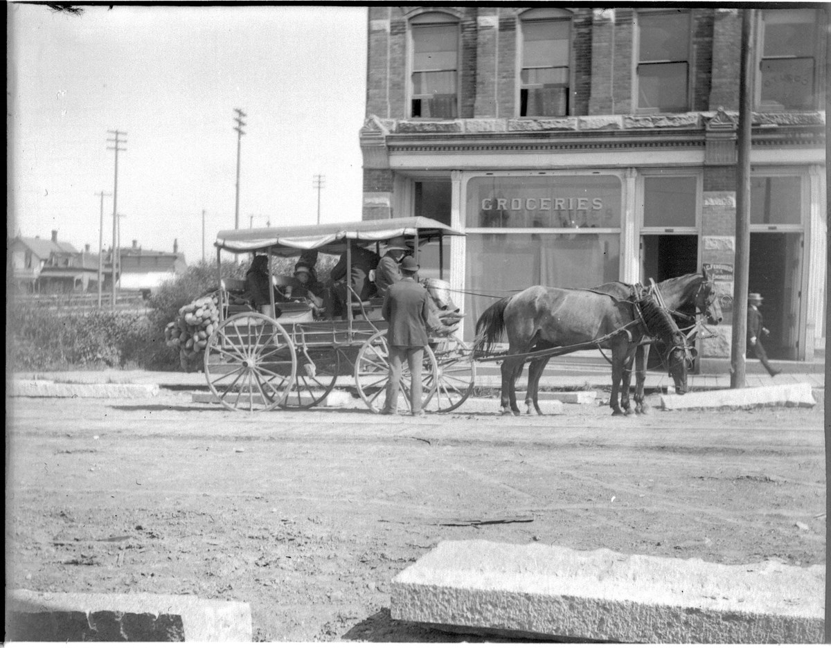
[Indigenous] vehicle in Vancouver (No.87). 7/20/94
https://archives.whyte.org/en/permalink/descriptions35453
- Part Of
- Vaux family fonds
- Date Range
- 1894
- Reference Code
- V653 / NA - 85
- Description Level
- 6 / Item
- GMD
- Photograph
- Negative
1 image
- Part Of
- Vaux family fonds
- Description Level
- 6 / Item
- Fonds Number
- M107 / V653
- Series
- I. Photography
- Sous-Fonds
- V653
- Sub-Series
- B. Travel 1894
- Reference Code
- V653 / NA - 85
- GMD
- Photograph
- Negative
- Date Range
- 1894
- Physical Description
- 1 negative : film
- Subject Access
- Discovery and Exploration
- Geographic Access
- British Columbia
- Creator
- Vaux family (Philadelphia USA)
- Title Source
- Title based on contents of file
- Processing Status
- Processed
Images
This material is presented as originally created; it may contain outdated cultural descriptions and
potentially offensive content.
Read more.
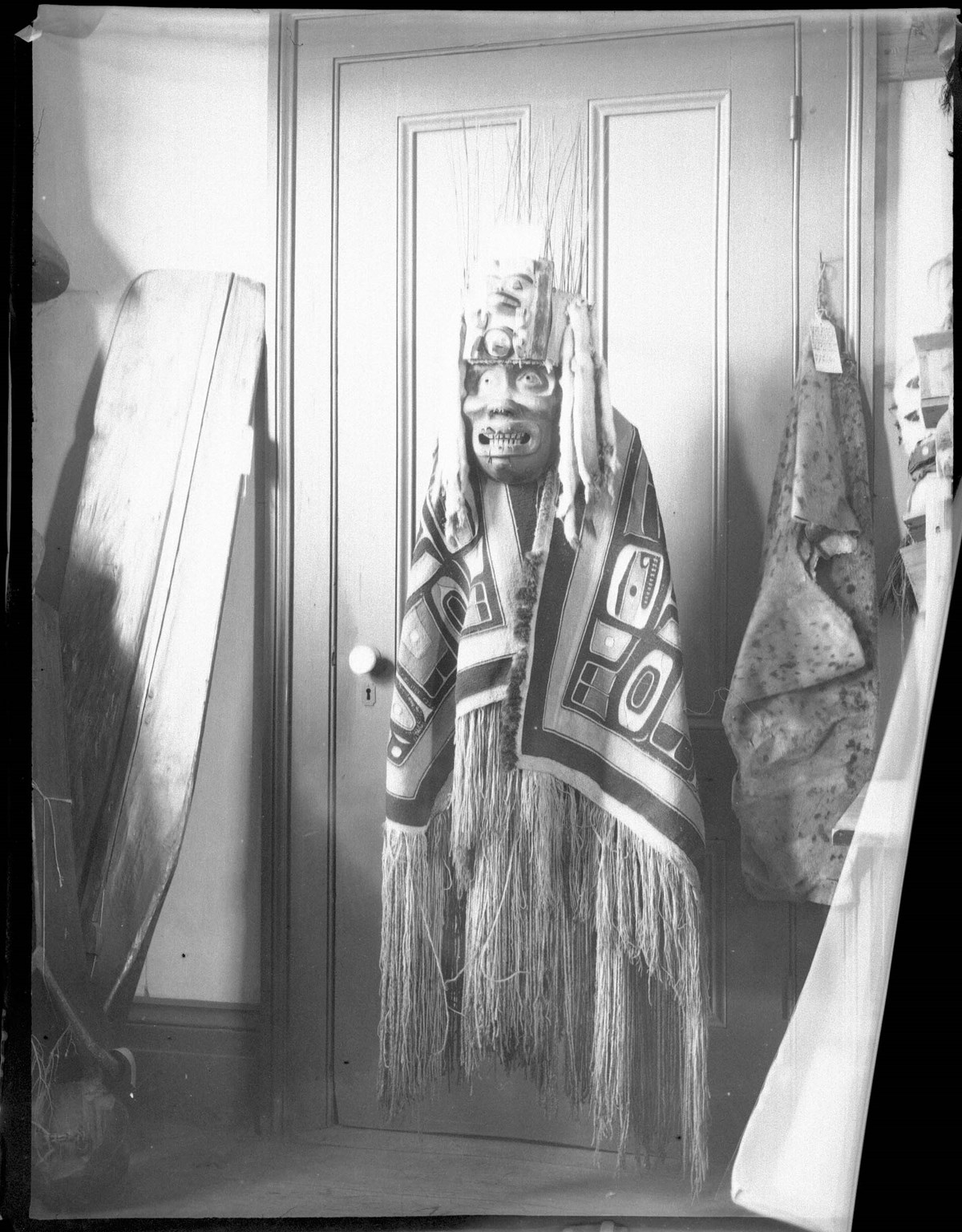
[Indigenous] head dress in British Columbia Museum. Victoria (No.93). 7/25/94
https://archives.whyte.org/en/permalink/descriptions35461
- Part Of
- Vaux family fonds
- Date Range
- 1894
- Reference Code
- V653 / NA - 93
- Description Level
- 6 / Item
- GMD
- Photograph
- Negative
1 image
- Part Of
- Vaux family fonds
- Description Level
- 6 / Item
- Fonds Number
- M107 / V653
- Series
- I. Photography
- Sous-Fonds
- V653
- Sub-Series
- B. Travel 1894
- Reference Code
- V653 / NA - 93
- GMD
- Photograph
- Negative
- Date Range
- 1894
- Physical Description
- 1 negative : film
- Subject Access
- Discovery and Exploration
- Geographic Access
- British Columbia
- Creator
- Vaux family (Philadelphia USA)
- Title Source
- Title based on contents of file
- Processing Status
- Processed
Images
This material is presented as originally created; it may contain outdated cultural descriptions and
potentially offensive content.
Read more.
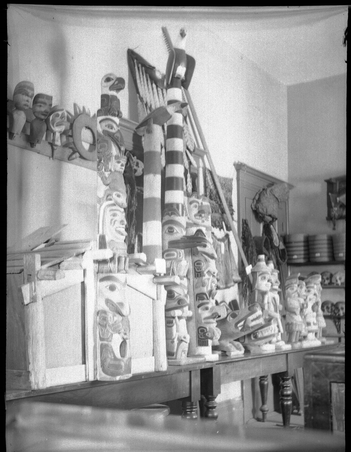
Collection of [Indigenous] totem poles in museum, Victoria (No.96). 7/25/94
https://archives.whyte.org/en/permalink/descriptions35462
- Part Of
- Vaux family fonds
- Date Range
- 1894
- Reference Code
- V653 / NA - 94
- Description Level
- 6 / Item
- GMD
- Photograph
- Negative
1 image
- Part Of
- Vaux family fonds
- Description Level
- 6 / Item
- Fonds Number
- M107 / V653
- Series
- I. Photography
- Sous-Fonds
- V653
- Sub-Series
- B. Travel 1894
- Reference Code
- V653 / NA - 94
- GMD
- Photograph
- Negative
- Date Range
- 1894
- Physical Description
- 1 negative : film
- Subject Access
- Discovery and Exploration
- Geographic Access
- British Columbia
- Creator
- Vaux family (Philadelphia USA)
- Title Source
- Title based on contents of file
- Processing Status
- Processed
Images
This material is presented as originally created; it may contain outdated cultural descriptions and
potentially offensive content.
Read more.
Personal Documents
https://archives.whyte.org/en/permalink/descriptions23022
- Part Of
- Hans Gmoser fonds
- Scope & Content
- One of three files pertaining to Personal Documents.
- Date Range
- 1880-2013
- Reference Code
- M224 / 30
- Description Level
- 5 / File
- Part Of
- Hans Gmoser fonds
- Description Level
- 5 / File
- Series
- IV.C. Textual records
- Accession Number
- 8111
- Reference Code
- M224 / 30
- Date Range
- 1880-2013
- Physical Description
- 2 cm of textual records.
- Scope & Content
- One of three files pertaining to Personal Documents.
- Subject Access
- Discovery and Exploration
- Environment and Nature
- Family and personal life
- Sports and Recreation
- Title Source
- Supplied title.
- Content Details
- Canadian Passport July 15, 1983-July 15, 1988 Canadian Passport June 30, 1988- June 30, 1993 Canadian Passport April 6, 1993-April 6, 1998 Canadian Passport Feb 18, 1998-Feb 18, 2003 Photocopy of Johann Wolfgang Gmoser’s Canadian Passport Jan 28, 2003-2008. Photocopy of Johann Wolfgang Gmoser’s Austrian Passport February 3, 2003-2013 Photocopy of passport? From an individual born in 1880.
- Processing Status
- Processed
This material is presented as originally created; it may contain outdated cultural descriptions and
potentially offensive content.
Read more.
Cartographic Materials
https://archives.whyte.org/en/permalink/descriptions23065
- Part Of
- Hans Gmoser fonds
- Scope & Content
- Cartographic materials in these four oversized files consist of the following:
- Date Range
- 1914-1973
- Reference Code
- M224 / O.S. Cartographic
- Description Level
- 5 / File
- Part Of
- Hans Gmoser fonds
- Description Level
- 5 / File
- Series
- IV.C. Textual records: Cartographic records
- Accession Number
- 7361, 7877, 8111
- Reference Code
- M224 / O.S. Cartographic
- Date Range
- 1914-1973
- Physical Description
- 48 cartographic records.
- Scope & Content
- Cartographic materials in these four oversized files consist of the following:
- Subject Access
- Discovery and Exploration
- Environment and Nature
- Family and personal life
- Sports and Recreation
- Title Source
- Title based on contents.
- Content Details
- Folder 1 Map on heavy paper, wrapped in plastic. “A Reconnaissance Topographic Map Suveyed and edited by Bradford Washburn” printed in Bern, Switzerland. Centred on Mt. McKinley.- From 7361. Palliser- Kananaskis Area British Columbia and Alberta- Publication No. 1962- Reprinted by the Surveys and Mapping Branch, Department of Mines and Technical Surveys, Ottawa. Mistaya British Columbia and Alberta- Compiled, drawn and printed at the office of the Surveyor General, Ottawa, 1931. Reprinted with corrections at the Surveys and Mapping Branch, Ottawa, 1950. National Topographic Series. Yoho British Columbia and Alberta- Compiled, drawn and printed at the office of the Surveyor General, Ottawa, 1932. Reprinted with corrections at the Surveys and Mapping Branch, Ottawa, 1952. National Topographic Series. Price 25 cents. Invermere British Columbia Kootenay Land District- National Topographic System- First Status Edition compiled and produced by the Geographic Division, Surveys, and Mapping Branch, Dept. of Lands, Forests and Water Resources, Victoria, BC 1964-65- annotated Beaton British Columbia Kootenay Land District- National Topographic System- First Status Edition compiled and produced by the Geographic Division, Surveys, and Mapping Branch, Dept. of Lands, Forests and Water Resources, Victoria, BC 1964-66- annotated Lardeau British Columbia Kootenay Land District- National Topographic System- First Status Edition compiled and produced by the Geographic Division, Surveys, and Mapping Branch, Dept. of Lands, Forests and Water Resources, Victoria, BC 1963- annotated Mount McKinley Alaska, Published by the Museum of Science, Boston, Mass, USA and the Swiss Foundation for Alpine Research, Zurich. 1960. Centennial Range Yukon Territory- M.C.R. 7 Edition 1- Produced and printed 1967 by the Surveys and Mapping Branch, Department of Energy, Mines and Resources- maps printed in 1961-62- annotated British Columbia Land Recording Dists.- Land Commissioner’s Offices- Department of Lands and Forests- first published 1957- Updated Nov. 1, 1960. Master Site Plan Bugaboo Creek Lodge Project number 6844- June 18, 1973- Cohos Delesalle & Evamy. Folder 2 Boundary Between Alberta and BC- Athabasca Pass- Sheet No. 27A – annotated- centered on Jasper Park Boundary Between Alberta and BC-All below Wheeler Maps (by hand) used for the Great Divide as per Chic-no topographical maps used for both Hans and similar maps were used by Chic bottom rip taped- Sheet No. 20- Drawn and printed by the Topographical Survey of Canada, Ottawa - centered on Clearwater forest and Lyell Icefield at bottom right Boundary Between Alberta and BC- Sheet No. 15- Drawn and printed at the Surveyor General’s Office, Ottawa, Canada- centered on Rocky Mountains Park Boundary Between Alberta and BC - Sheet No. 19- Drawn and printed at the Surveyor General’s Office, Ottawa, Canada- centered on centered on Clearwater Forest with Mt. Alan Campbell at bottom Boundary Between Alberta and BC- Sheet No. 25- annotated- Drawn and printed by the Topographical Survey of Canada, Ottawa - centered on Jasper Park with Chisel Peak at bottom Boundary Between Alberta and BC- Sheet No. 19- dirt and annotated- revised 1925- drawn and printed by the Topographical Survey of Canada, Ottawa- centered on Clearwater and Push Pass W. Boundary Between Alberta and BC- annotated- Sheet 16- revised 1925- drawn and printed by the Topographical Survey of Canada, Ottawa- centered on Yoho Park and Rocky Mountains Park Steele Glacier- Topographical Survey 1967 Arial Photography 1951 Mount St. Elias Canada- United State of America- Produced and Printed by the Surveys and Mapping Branch, Department of Mines and Technical Surveys 1962 from air photographs taken in 1951 and 1956- annotated Woolsey Glacier- Revelstoke National Park British Columbia – Printed by the Surveys and Mapping Branch Department of Energy, Mines and Resources- 1967 Windermere Kootenay District- Map 165A Issued 1918- Reprinted by the Surveys and Mapping Branch, Department of Mines and Technical Surveys, Ottawa. Folder 3 Boundary Between Alberta and BC- Sheet No. 20- heavily annotated- revised 1925- drawn and printed by the Topographical Survey of Canada, Ottawa- centered on Clearwater Forest, Saskatchewan Glacier at top left Boundary Between Alberta and BC- Sheet No. 18- heavily ripped- annotated - notes on back- revised 1925- drawn and printed by the Topographical Survey of Canada, Ottawa- centered on Clearwater Forest, Mt Mummery at bottom Boundary Between Alberta and BC- Sheet No. 17 (in pencil “A and B”)- annotated - heavily ripped- drawn and printed at the Surveyor Generals’ Office- centered on Clearwater Forest and Yoho Park Boundary Between Alberta and BC- Sheet No. 26- annotated- revised 1925- drawn and printed by the Topographical Survey of Canada, Ottawa- centered on Jasper Park and Icefields Boundary Between Alberta and BC- Sheet No. 17- revised 1925- drawn and printed by the Topographical Survey of Canada, Ottawa- centered on Clearwater Forest and Yoho Park Boundary Between Alberta and BC- Sheet No. 28- stained- centered on Jasper Park Boundary Between Alberta and BC- Sheet No. 24- annotated- revised edition, 1925- drawn and printed by the Topographical Survey of Canada, Ottawa- centered on Jasper Park Boundary Between Alberta and BC- Sheet No. 16- annotated- revised 1925- drawn and printed by the Topographical Survey of Canada, Ottawa- centered on Yoho and Rocky Mountains Park Interprovincial Boundary Commission Boundary Between Alberta and British Columbia. Revised edition 1925 drawn and printed by the Topographical Survey of Canada, Ottawa. Sheet No. 27. Following maps are from accession 7877. Interprovincial Boundary Commission Boundary Between Alberta and British Columbia. Surveyed 1920. Drawn and printed by the Topographical Survey of Canada, Ottawa. Sheet No. 26. Interprovincial Boundary Commission Boundary Between Alberta and British Columbia. Surveyed 1920, 1921. Drawn and printed by the Topographical Survey of Canada, Ottawa. Sheet No. 25. Interprovincial Boundary Commission Boundary Between Alberta and British Columbia. Surveyed 1919, 1921. Drawn and printed by the Topographical Survey of Canada, Ottawa. Sheet No. 24. Interprovincial Boundary Commission Boundary Between Alberta and British Columbia. Revised edition 1925 drawn and printed by the Topographical Survey of Canada, Ottawa. Sheet No. 21. Interprovincial Boundary Commission Boundary Between Alberta and British Columbia. Revised edition 1925 drawn and printed by the Topographical Survey of Canada, Ottawa. Sheet No. 18. Interprovincial Boundary Commission Boundary Between Alberta and British Columbia. Surveyed 1913. Drawn and printed by the Topographical Survey of Canada, Ottawa. Sheet No. 13 A. Interprovincial Boundary Commission Boundary Between Alberta and British Columbia. Surveyed 1916. Drawn and printed by the Topographical Survey of Canada, Ottawa. Sheet No. 12 A. Interprovincial Boundary Commission Boundary Between Alberta and British Columbia. Surveyed 1916. Drawn and printed by the Topographical Survey of Canada, Ottawa. Sheet No. 11. Interprovincial Boundary Commission Boundary Between Alberta and British Columbia. Surveyed 1916. Drawn and printed by the Topographical Survey of Canada, Ottawa. Sheet No. 10. Interprovincial Boundary Commission Boundary Between Alberta and British Columbia. Surveyed 1916. Drawn and printed by the Topographical Survey of Canada, Ottawa. Sheet No. 9. Interprovincial Boundary Commission Boundary Between Alberta and British Columbia. Surveyed 1916. Drawn and printed by the Topographical Survey of Canada, Ottawa. Sheet No. 8. Interprovincial Boundary Commission Boundary Between Alberta and British Columbia. Surveyed 1916. Drawn and printed by the Topographical Survey of Canada, Ottawa. Sheet No. 6. Interprovincial Boundary Commission Boundary Between Alberta and British Columbia. Surveyed 1915. Drawn and printed by the Topographical Survey of Canada, Ottawa. Sheet No. 5. Interprovincial Boundary Commission Boundary Between Alberta and British Columbia. Surveyed 1914. Drawn and printed by the Topographical Survey of Canada, Ottawa. Sheet No. 4. Interprovincial Boundary Commission Boundary Between Alberta and British Columbia. Surveyed 1922. Drawn and printed by the Topographical Survey of Canada, Ottawa. Sheet No. 31. Interprovincial Boundary Commission Boundary Between Alberta and British Columbia. Surveyed 1922, 1924. Drawn and printed by the Topographical Survey of Canada, Ottawa. Sheet No. 30. Interprovincial Boundary Commission Boundary Between Alberta and British Columbia. Surveyed 1917. Drawn and printed by the Topographical Survey of Canada, Ottawa. Sheet No. 29.
- Processing Status
- Processed
This material is presented as originally created; it may contain outdated cultural descriptions and
potentially offensive content.
Read more.
[Hunting party preparing to depart from Banff Indian Grounds or Brewster Corrals, Banff]
https://archives.whyte.org/en/permalink/descriptions49289
- Part Of
- Pat Brewster fonds
- Scope & Content
- Image of five people on horseback with five pack horses
- Date Range
- 1850-1910
- Reference Code
- v91 / 12 / a / na66 - 1716
- Description Level
- 6 / Item
- GMD
- Photograph
- Negative, copy
- Photograph, print
1 image
- Part Of
- Pat Brewster fonds
- Description Level
- 6 / Item
- Fonds Number
- M2 / V91 / S21
- Sous-Fonds
- V91
- Reference Code
- v91 / 12 / a / na66 - 1716
- Date Range
- 1850-1910
- Physical Description
- 1 photograph : negative : copy negative
- Scope & Content
- Image of five people on horseback with five pack horses
- Subject Access
- Discovery and Exploration
- Environment and Nature
- Sports and Recreation
- Transportation
- Geographic Access
- Alberta
- British Columbia
- Title Source
- Title based on contents of file
- Processing Status
- Processed
Images

This material is presented as originally created; it may contain outdated cultural descriptions and
potentially offensive content.
Read more.
Pyramid (Chephren) Lake end, Howse Peak, Icefield trip?
https://archives.whyte.org/en/permalink/descriptions31131
- Part Of
- Byron Harmon fonds
- Date Range
- [between 1903 and 1942]
- Reference Code
- V263 / NA - 5724
- Description Level
- 6 / Item
- GMD
- Photograph
- Negative
1 image
- Part Of
- Byron Harmon fonds
- Description Level
- 6 / Item
- Fonds Number
- V263
- Series
- I. Scenic / commercial series
- Sub-Series
- A.1.a. Negatives, Main series : 13 x 18 cm and smaller
- Reference Code
- V263 / NA - 5724
- GMD
- Photograph
- Negative
- Date Range
- [between 1903 and 1942]
- Physical Description
- 1 photograph : negative, 13 x 18 cm or smaller
- Subject Access
- Discovery and Exploration
- Environment and Nature
- Geographic Access
- Alberta
- Creator
- Byron Harmon (Banff, Alberta)
Images

This material is presented as originally created; it may contain outdated cultural descriptions and
potentially offensive content.
Read more.
932. Crowfoot Glacier, Icefield trip?
https://archives.whyte.org/en/permalink/descriptions31134
- Part Of
- Byron Harmon fonds
- Date Range
- [between 1903 and 1942]
- Reference Code
- V263 / NA - 5727
- Description Level
- 6 / Item
- GMD
- Photograph
- Negative
1 image
- Part Of
- Byron Harmon fonds
- Description Level
- 6 / Item
- Fonds Number
- V263
- Series
- I. Scenic / commercial series
- Sub-Series
- A.1.a. Negatives, Main series : 13 x 18 cm and smaller
- Reference Code
- V263 / NA - 5727
- GMD
- Photograph
- Negative
- Date Range
- [between 1903 and 1942]
- Physical Description
- 1 photograph : negative, 13 x 18 cm or smaller
- Subject Access
- Discovery and Exploration
- Environment and Nature
- Geographic Access
- Alberta
- Creator
- Byron Harmon (Banff, Alberta)
Images

This material is presented as originally created; it may contain outdated cultural descriptions and
potentially offensive content.
Read more.
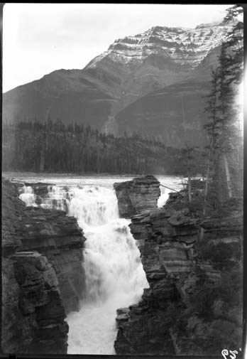
29. Athabasca Falls, Icefield trip?
https://archives.whyte.org/en/permalink/descriptions31143
- Part Of
- Byron Harmon fonds
- Date Range
- [between 1903 and 1942]
- Reference Code
- V263 / NA - 5736
- Description Level
- 6 / Item
- GMD
- Photograph
- Negative
1 image
- Part Of
- Byron Harmon fonds
- Description Level
- 6 / Item
- Fonds Number
- V263
- Series
- I. Scenic / commercial series
- Sub-Series
- A.1.a. Negatives, Main series : 13 x 18 cm and smaller
- Reference Code
- V263 / NA - 5736
- GMD
- Photograph
- Negative
- Date Range
- [between 1903 and 1942]
- Physical Description
- 1 photograph : negative, 13 x 18 cm or smaller
- Subject Access
- Discovery and Exploration
- Environment and Nature
- Geographic Access
- Alberta
- Creator
- Byron Harmon (Banff, Alberta)
Images
This material is presented as originally created; it may contain outdated cultural descriptions and
potentially offensive content.
Read more.
Columbia trip, Maligne Lake, stereo
https://archives.whyte.org/en/permalink/descriptions31294
- Part Of
- Byron Harmon fonds
- Scope & Content
- Jasper National Park
- Date Range
- [between 1903 and 1942]
- Reference Code
- V263 / NA - 5894
- Description Level
- 6 / Item
- GMD
- Photograph
- Negative
1 image
- Part Of
- Byron Harmon fonds
- Description Level
- 6 / Item
- Fonds Number
- V263
- Series
- I. Scenic / commercial series
- Sub-Series
- A.1.a. Negatives, Main series : 13 x 18 cm and smaller
- Reference Code
- V263 / NA - 5894
- GMD
- Photograph
- Negative
- Date Range
- [between 1903 and 1942]
- Physical Description
- 1 photograph : negative, 13 x 18 cm or smaller
- Scope & Content
- Jasper National Park
- Subject Access
- Discovery and Exploration
- Environment and Nature
- Geographic Access
- Alberta
- Creator
- Byron Harmon (Banff, Alberta)
Images

This material is presented as originally created; it may contain outdated cultural descriptions and
potentially offensive content.
Read more.
Columbia trip, Maligne Lake, stereo
https://archives.whyte.org/en/permalink/descriptions31298
- Part Of
- Byron Harmon fonds
- Scope & Content
- Jasper National Park
- Date Range
- [between 1903 and 1942]
- Reference Code
- V263 / NA - 5898
- Description Level
- 6 / Item
- GMD
- Photograph
- Negative
1 image
- Part Of
- Byron Harmon fonds
- Description Level
- 6 / Item
- Fonds Number
- V263
- Series
- I. Scenic / commercial series
- Sub-Series
- A.1.a. Negatives, Main series : 13 x 18 cm and smaller
- Reference Code
- V263 / NA - 5898
- GMD
- Photograph
- Negative
- Date Range
- [between 1903 and 1942]
- Physical Description
- 1 photograph : negative, 13 x 18 cm or smaller
- Scope & Content
- Jasper National Park
- Subject Access
- Discovery and Exploration
- Environment and Nature
- Geographic Access
- Alberta
- Creator
- Byron Harmon (Banff, Alberta)
Images

This material is presented as originally created; it may contain outdated cultural descriptions and
potentially offensive content.
Read more.
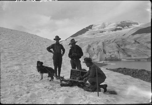
Trip to Columbia Icefield, with radio set on the Icefield
https://archives.whyte.org/en/permalink/descriptions31847
- Part Of
- Byron Harmon fonds
- Date Range
- [between 1903 and 1942]
- Reference Code
- V263 / NA - 6133
- Description Level
- 6 / Item
- GMD
- Photograph
- Negative
1 image
- Part Of
- Byron Harmon fonds
- Description Level
- 6 / Item
- Fonds Number
- V263
- Series
- I. Scenic / commercial series
- Sub-Series
- A.1.a. Negatives, Main series : 13 x 18 cm and smaller
- Reference Code
- V263 / NA - 6133
- GMD
- Photograph
- Negative
- Date Range
- [between 1903 and 1942]
- Physical Description
- 1 photograph : negative, 13 x 18 cm or smaller
- Subject Access
- Discovery and Exploration
- Environment and Nature
- Geographic Access
- Alberta
- Conservation
- Reprocessed / archival quality gold-toned, 1973
- Creator
- Byron Harmon (Banff, Alberta)
Images
This material is presented as originally created; it may contain outdated cultural descriptions and
potentially offensive content.
Read more.
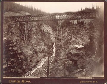
639. Stoney Creek Bridge, C.P.R., Selkirks, height 296 ft.
https://archives.whyte.org/en/permalink/descriptions32392
- Date Range
- [1890 or 1891]
- Reference Code
- V650 / 6603 - PA - 4
- Description Level
- 6 / Item
- GMD
- Photograph
1 image
- Description Level
- 6 / Item
- Fonds Number
- V650
- Reference Code
- V650 / 6603 - PA - 4
- GMD
- Photograph
- Date Range
- [1890 or 1891]
- Physical Description
- 1 photograph : print, 18 x 24 cm, mounted
- Subject Access
- Discovery and Exploration
- Geographic Access
- British Columbia
Images
This material is presented as originally created; it may contain outdated cultural descriptions and
potentially offensive content.
Read more.
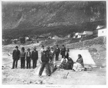
Unidentified Indigenous people at Yale
https://archives.whyte.org/en/permalink/descriptions32560
- Part Of
- Charles Macmunn fonds
- Scope & Content
- Print is from "Macmunn's Views of Canadian Pacific Railway, Victoria and Surroundings" (presentation album of 144 views)
- Date Range
- [ca.1890]
- Reference Code
- V256 / PD 1 - 20
- Description Level
- 6 / Item
- GMD
- Album
- Photograph print
1 image
- Part Of
- Charles Macmunn fonds
- Description Level
- 6 / Item
- Fonds Number
- V256
- Sous-Fonds
- V256
- Reference Code
- V256 / PD 1 - 20
- Parallel Title
- 62. Indian group at Yale
- Other Title Info
- Parallel title is original title
- Date Range
- [ca.1890]
- Physical Description
- 1 photograph : print, 19 x 24 cm
- Scope & Content
- Print is from "Macmunn's Views of Canadian Pacific Railway, Victoria and Surroundings" (presentation album of 144 views)
- Subject Access
- Discovery and Exploration
- First nations
- Railways
- Geographic Access
- British Columbia
- Creator
- Charles Macmunn (Victoria, BC)
- Title Source
- Title based on contents of file
- Processing Status
- Processed
Images
This material is presented as originally created; it may contain outdated cultural descriptions and
potentially offensive content.
Read more.
Unidentified Indigneous people, Yale
https://archives.whyte.org/en/permalink/descriptions32566
- Part Of
- Charles Macmunn fonds
- Scope & Content
- Print is from "Macmunn's Views of Canadian Pacific Railway, Victoria and Surroundings" (presentation album of 144 views)
- Date Range
- [ca.1890]
- Reference Code
- V256 / PD 1 - 26
- Description Level
- 6 / Item
- GMD
- Album
- Photograph print
1 image
- Part Of
- Charles Macmunn fonds
- Description Level
- 6 / Item
- Fonds Number
- V256
- Sous-Fonds
- V256
- Reference Code
- V256 / PD 1 - 26
- Parallel Title
- 273. Indian fishing group, Yale
- Other Title Info
- Parallel title is original title
- Date Range
- [ca.1890]
- Physical Description
- 1 photograph : print, 19 x 24 cm
- Scope & Content
- Print is from "Macmunn's Views of Canadian Pacific Railway, Victoria and Surroundings" (presentation album of 144 views)
- Subject Access
- Discovery and Exploration
- First nations
- Railways
- Geographic Access
- British Columbia
- Creator
- Charles Macmunn (Victoria, BC)
- Title Source
- Title based on contents of file
- Processing Status
- Processed
Images
This material is presented as originally created; it may contain outdated cultural descriptions and
potentially offensive content.
Read more.
- Part Of
- Charles Macmunn fonds
- Scope & Content
- Print is from "Macmunn's Views of Canadian Pacific Railway, Victoria and Surroundings" (presentation album of 144 views)
- Date Range
- [ca.1890]
- Reference Code
- V256 / PD 1 - 33
- Description Level
- 6 / Item
- GMD
- Album
- Photograph print
1 image
- Part Of
- Charles Macmunn fonds
- Description Level
- 6 / Item
- Fonds Number
- V256
- Sous-Fonds
- V256
- Reference Code
- V256 / PD 1 - 33
- Parallel Title
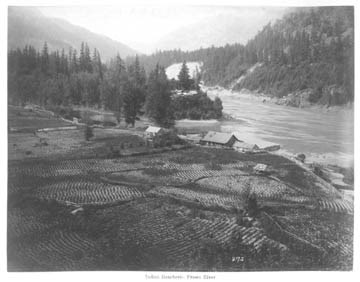
- 275. Indian Rancherie, Fraser River
- Other Title Info
- Parallel title is original title
- Date Range
- [ca.1890]
- Physical Description
- 1 photograph : print, 19 x 24 cm
- Scope & Content
- Print is from "Macmunn's Views of Canadian Pacific Railway, Victoria and Surroundings" (presentation album of 144 views)
- Subject Access
- Discovery and Exploration
- First nations
- Railways
- Geographic Access
- British Columbia
- Creator
- Charles Macmunn (Victoria, BC)
- Title Source
- Title based on contents of file
- Processing Status
- Processed
Images
This material is presented as originally created; it may contain outdated cultural descriptions and
potentially offensive content.
Read more.
Indigenous Cemetery
https://archives.whyte.org/en/permalink/descriptions32579
- Part Of
- Charles Macmunn fonds
- Scope & Content
- Print is from "Macmunn's Views of Canadian Pacific Railway, Victoria and Surroundings" (presentation album of 144 views)
- Date Range
- [ca.1890]
- Reference Code
- V256 / PD 1 - 39
- Description Level
- 6 / Item
- GMD
- Album
- Photograph print
1 image
- Part Of
- Charles Macmunn fonds
- Description Level
- 6 / Item
- Fonds Number
- V256
- Sous-Fonds
- V256
- Reference Code
- V256 / PD 1 - 39
- Parallel Title
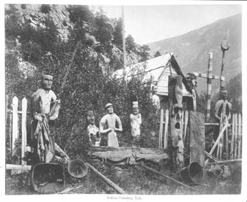
- 262. Indian Cemetery, Yale
- Other Title Info
- Original title
- Date Range
- [ca.1890]
- Physical Description
- 1 photograph : print, 19 x 24 cm
- Scope & Content
- Print is from "Macmunn's Views of Canadian Pacific Railway, Victoria and Surroundings" (presentation album of 144 views)
- Subject Access
- Discovery and Exploration
- First nations
- Railways
- Geographic Access
- British Columbia
- Creator
- Charles Macmunn (Victoria, BC)
- Title Source
- Title based on contents of file
- Processing Status
- Processed
Images
This material is presented as originally created; it may contain outdated cultural descriptions and
potentially offensive content.
Read more.
Illecillewaet Glacier
https://archives.whyte.org/en/permalink/descriptions34125
- Part Of
- Vaux family fonds
- Scope & Content
- Illecillewaet Glacier, Selkirk Mountains
- Date Range
- [1898]
- Reference Code
- V653 / PS - 25
- Description Level
- 6 / Item
- GMD
- Lantern slide
- Photograph
- Transparency
1 image
- Part Of
- Vaux family fonds
- Description Level
- 6 / Item
- Fonds Number
- M107 / V653
- Series
- I. Photography
- Sous-Fonds
- V653
- Sub-Series
- V. Lantern slides
- Accession Number
- .
- Reference Code
- V653 / PS - 25
- Date Range
- [1898]
- Physical Description
- 1 transparency : lantern slide
- Scope & Content
- Illecillewaet Glacier, Selkirk Mountains
- Notes
- Hand-coloured by Mary M. Vaux
- Subject Access
- Discovery and Exploration
- Language
- English
- Creator
- Vaux family (Philadelphia USA)
- Title Source
- Title based on contents of file
- Processing Status
- Processed
Images

This material is presented as originally created; it may contain outdated cultural descriptions and
potentially offensive content.
Read more.
Ross Peak from near Soup Glacier / Vaux
https://archives.whyte.org/en/permalink/descriptions34228
- Part Of
- Vaux family fonds
- Scope & Content
- Selkirk Mountains
- Date Range
- [between 1894 and 1912]
- Reference Code
- V653 / PS - 131
- Description Level
- 6 / Item
- GMD
- Transparency
- Lantern slide
1 image
- Part Of
- Vaux family fonds
- Description Level
- 6 / Item
- Fonds Number
- M107 / V653
- Series
- I. Photography
- Sub-Series
- V. Lantern slides
- Reference Code
- V653 / PS - 131
- Date Range
- [between 1894 and 1912]
- Physical Description
- 1 transparency : lantern slide
- Scope & Content
- Selkirk Mountains
- Subject Access
- Discovery and Exploration
- Geographic Access
- British Columbia
- Creator
- Vaux family (Philadelphia USA)
Images
This material is presented as originally created; it may contain outdated cultural descriptions and
potentially offensive content.
Read more.
- Part Of
- Vaux family fonds
- Date Range
- [between 1894 and 1912]
- Reference Code
- V653 / PS - 133
- Description Level
- 6 / Item
- GMD
- Transparency
- Lantern slide
1 image
- Part Of
- Vaux family fonds
- Description Level
- 6 / Item
- Fonds Number
- M107 / V653
- Series
- I. Photography
- Sub-Series
- V. Lantern slides
- Reference Code
- V653 / PS - 133
- Date Range
- [between 1894 and 1912]
- Physical Description
- 1 transparency : lantern slide
- Notes
- Made from negative WMCR/V653/NA-931
- Subject Access
- Discovery and Exploration
- Creator
- Vaux family (Philadelphia USA)
Images
This material is presented as originally created; it may contain outdated cultural descriptions and
potentially offensive content.
Read more.