Narrow Results By
- Peter and Catharine Whyte fonds 609
- Vaux family fonds 163
- Luxton family fonds 127
- Boorne and May fonds 106
- Nicholas Morant fonds 97
- Bruno Engler fonds 68
- George McLean fonds 37
- Moore family fonds 28
- Kidney family fonds 27
- Trail Riders of the Canadian Rockies fonds 18
- Archives General File Collection 15
- George Paris fonds 12
Sketch of Western Section Standard Survey by W. King and Montague Aldons
https://archives.whyte.org/en/permalink/catalogue21478
- Medium
- Library - Maps and blueprints (unannotated; published)
- Map
- Published Date
- 1880
- Call Number
- C12-1.5
- Responsibility
- W. King and Montague Aldons
- Published Date
- 1880
- Subjects
- Western Canada
- Notes
- Photostatic copy from Public Archives
- two sections
- Accession Number
- 675
- Call Number
- C12-1.5
- Collection
- Archives Library
This material is presented as originally created; it may contain outdated cultural descriptions and
potentially offensive content.
Read more.
Copy of Map of "Colton's North America"
https://archives.whyte.org/en/permalink/catalogue21525
- Medium
- Library - Maps and blueprints (unannotated; published)
- Map
- Published Date
- 1882
- Publisher
- G.W. and C.B. Colton and Co.
- Call Number
- C13-4.4
- Publisher
- G.W. and C.B. Colton and Co.
- Published Date
- 1882
- Subjects
- North America
- Accession Number
- 11,500
- Call Number
- C13-4.4
- Collection
- Archives Library
This material is presented as originally created; it may contain outdated cultural descriptions and
potentially offensive content.
Read more.
Map shewing the Distribution of the Indian Tribes of British Columbia by W.F. Tolmie and G.M. Dawson
https://archives.whyte.org/en/permalink/catalogue21365
- Medium
- Library - Maps and blueprints (unannotated; published)
- Map
- Published Date
- 1883
- Publisher
- Geological and Natural History Survey of Canada
- Call Number
- C6-10.2(a)
- Responsibility
- W.F. Tolmie and G.M. Dawson
- Publisher
- Geological and Natural History Survey of Canada
- Published Date
- 1883
- Subjects
- Indian Tribes of British Columbia
- Notes
- Accompanies "Comparative Vocabularies of the Indian Tribes of B.C."
- Accession Number
- 400
- Call Number
- C6-10.2(a)
- Collection
- Archives Library
This material is presented as originally created; it may contain outdated cultural descriptions and
potentially offensive content.
Read more.
Map shewing the Distribution of the Indian Tribes of British Columbia by W.F. Tolmie and G.M. Dawson
https://archives.whyte.org/en/permalink/catalogue21395
- Medium
- Library - Maps and blueprints (unannotated; published)
- Map
- Published Date
- 1883
- Publisher
- Geological and Natural History Survey of Canada
- Call Number
- C6-10.2(a)
- Responsibility
- W.F. Tolmie and G.M. Dawson
- Publisher
- Geological and Natural History Survey of Canada
- Published Date
- 1883
- Subjects
- Indian Tribes of British Columbia
- Notes
- Accompanies "Comparative Vocabularies of the Indian Tribes of B.C."
- Accession Number
- 400
- Call Number
- C6-10.2(a)
- Collection
- Archives Library
This material is presented as originally created; it may contain outdated cultural descriptions and
potentially offensive content.
Read more.
North West Territories including the province of Manitoba
https://archives.whyte.org/en/permalink/catalogue21496
- Medium
- Library - Maps and blueprints (unannotated; published)
- Map
- Published Date
- 1883
- Call Number
- C12-1.21
- Published Date
- 1883
- Subjects
- Indian Treaties
- Notes
- Photostatic copy from Public Archives
- two sections
- Accession Number
- 675
- Call Number
- C12-1.21
- Collection
- Archives Library
This material is presented as originally created; it may contain outdated cultural descriptions and
potentially offensive content.
Read more.
[Province of British Columbia]
https://archives.whyte.org/en/permalink/catalogue24538
- Medium
- Library - Maps and blueprints (unannotated; published)
- Map
- Published Date
- 1884
- Author
- Mohun, Edward
- Call Number
- C10-10.1
- Author
- Mohun, Edward
- Published Date
- 1884
- Scale
- Scale: 1 inch - 50 miles
- Subjects
- British Columbia
- Notes
- Compiled and drawn by Edward Moun, C.E.
- Accession Number
- 440
- Call Number
- C10-10.1
- Collection
- Archives Library
This material is presented as originally created; it may contain outdated cultural descriptions and
potentially offensive content.
Read more.
[North-West Territory]
https://archives.whyte.org/en/permalink/catalogue21498
- Medium
- Library - Maps and blueprints (unannotated; published)
- Map
- Published Date
- 1884
- Call Number
- C12-1.24
- Published Date
- 1884
- Subjects
- North-West Territory
- Notes
- Photostatic copy from Public Archives
- Accession Number
- 675
- Call Number
- C12-1.24
- Collection
- Archives Library
This material is presented as originally created; it may contain outdated cultural descriptions and
potentially offensive content.
Read more.
Geological maps
https://archives.whyte.org/en/permalink/catalogue24792
- Medium
- Library - Book (including soft-cover and pamphlets)
- Map
- Published Date
- 1885
- Publisher
- Geological and Natural History Survey of Canada
- Call Number
- C7-6.19
- Publisher
- Geological and Natural History Survey of Canada
- Published Date
- 1885
- Scale
- 1:506,880
- Notes
- (a) Geological and Topographical
- (b) Surface Character
- Accession Number
- 400
- Call Number
- C7-6.19
- Collection
- Archives Library
This material is presented as originally created; it may contain outdated cultural descriptions and
potentially offensive content.
Read more.
Geological and Nat. Historical Survey
https://archives.whyte.org/en/permalink/catalogue24681
- Medium
- Library - Book (including soft-cover and pamphlets)
- Map
- Published Date
- 1886
- Publisher
- Burland Lithographic Co., Montreal
- Call Number
- C7-1.4
- Publisher
- Burland Lithographic Co., Montreal
- Published Date
- 1886
- Scale
- 2 miles to 1 inch
- Subjects
- Rocky Mountains
- Notes
- Cross section in the vicinity of the Canadian Pacific Railway
- Accession Number
- 400
- Call Number
- C7-1.4
- Collection
- Archives Library
This material is presented as originally created; it may contain outdated cultural descriptions and
potentially offensive content.
Read more.
Geological map of part of the Cascade Coal Basin, Rocky Mountains
https://archives.whyte.org/en/permalink/catalogue21453
- Medium
- Library - Book (including soft-cover and pamphlets)
- Map
- Published Date
- 1886
- Author
- White, J.
- Call Number
- C7-1.1
- Author
- White, J.
- Published Date
- 1886
- Subjects
- Cascade Coal Basin
- Alberta
- Notes
- To illustrate report by George M. Dawson D.S. F.G.S.
- Topography chiefly from sketches and Surveys by J. White C.E. with additions by R.G. McConnell, B.A.
- Accession Number
- 400
- Call Number
- C7-1.1
- Collection
- Archives Library
This material is presented as originally created; it may contain outdated cultural descriptions and
potentially offensive content.
Read more.
Projected Township Lines
https://archives.whyte.org/en/permalink/catalogue21499
- Medium
- Library - Maps and blueprints (unannotated; published)
- Map
- Published Date
- 1886
- Publisher
- Dept. of the Interior
- Call Number
- C12-1.25
- Publisher
- Dept. of the Interior
- Published Date
- 1886
- Subjects
- North West Territories
- Notes
- Photostatic copy from Public Archives
- Accession Number
- 675
- Call Number
- C12-1.25
- Collection
- Archives Library
This material is presented as originally created; it may contain outdated cultural descriptions and
potentially offensive content.
Read more.
Group portrait
https://archives.whyte.org/en/permalink/descriptions53280
- Part Of
- Peter and Catharine Whyte fonds
- Scope & Content
- Image of three First Nations men posed with Reverends McDougall and Stunhaues[?] in a studio setting - "Standing Chief Samson & Rev. R.B. Stunhaues[?] L to R Rev. John McDougall Chief Paken[?] Chief Jonas Big Stoney" written on the back in blue ink
- Date Range
- 1886
- Reference Code
- V683 / III / A / 15 / PA - 848
- Description Level
- 6 / Item
- GMD
- Photograph
2 images
- Part Of
- Peter and Catharine Whyte fonds
- Description Level
- 6 / Item
- Fonds Number
- M36 / V683 / S37
- Series
- V683 / III / A / 15 : Peter and Catharine Whyte: Collected Photographs
- Sous-Fonds
- V683
- Accession Number
- .
- Reference Code
- V683 / III / A / 15 / PA - 848
- GMD
- Photograph
- Date Range
- 1886
- Physical Description
- Photograph: 1 print (front and back) ; b&w.
- Scope & Content
- Image of three First Nations men posed with Reverends McDougall and Stunhaues[?] in a studio setting - "Standing Chief Samson & Rev. R.B. Stunhaues[?] L to R Rev. John McDougall Chief Paken[?] Chief Jonas Big Stoney" written on the back in blue ink
- Notes
- Copyright: Ernest Brown collection
- Name Access
- Big Stoney, Jonas
- McDougall, John
- Subject Access
- First Nations
- Indigenous Peoples
- Portrait
- Recognizing relations
- Stoney
- Stoney Nakoda
- Language
- English
- Title Source
- Title based on item
- Processing Status
- Processed
Images


This material is presented as originally created; it may contain outdated cultural descriptions and
potentially offensive content.
Read more.
Range 1, West of Fifth Meridian
https://archives.whyte.org/en/permalink/catalogue24490
- Medium
- Library - Maps and blueprints (unannotated; published)
- Map
- Published Date
- 1887
- Publisher
- Dominion Lands Office
- Call Number
- C9-7.34
- Publisher
- Dominion Lands Office
- Published Date
- 1887
- Scale
- 1 mile: 2 inches
- Subjects
- Township #34
- Notes
- photostatic copy from Public Archives
- Accession Number
- 675
- Call Number
- C9-7.34
- Collection
- Archives Library
This material is presented as originally created; it may contain outdated cultural descriptions and
potentially offensive content.
Read more.
Range 1, West of Fifth Meridian, Red Deer-Little Red Deer River Area
https://archives.whyte.org/en/permalink/catalogue24492
- Medium
- Library - Maps and blueprints (unannotated; published)
- Map
- Published Date
- 1887
- Publisher
- Dominion Lands Office, Ottawa
- Call Number
- C9-7.35
- Publisher
- Dominion Lands Office, Ottawa
- Published Date
- 1887
- Scale
- 1 mile: 2 inches
- Subjects
- Township #35
- Notes
- photostatic copy from Public Archives
- Accession Number
- 675
- Call Number
- C9-7.35
- Collection
- Archives Library
This material is presented as originally created; it may contain outdated cultural descriptions and
potentially offensive content.
Read more.
Plan of the town of Anthracite. Being portions of N1/2. Section 5 and S.W. 1/4 Section 8, Tp 26, $11, W5
https://archives.whyte.org/en/permalink/catalogue21319
- Medium
- Library - Maps and blueprints (unannotated; published)
- Map
- Published Date
- 1887
- Call Number
- C4-2.3(b)
- Published Date
- 1887
- Subjects
- Anthracite
- Notes
- Stewart Avenue and Thorpe Ave.."This plan is correct and is prepared under provisions of 'The Territories Real Property Act'"
- Accession Number
- 938
- Call Number
- C4-2.3(b)
- Collection
- Archives Library
This material is presented as originally created; it may contain outdated cultural descriptions and
potentially offensive content.
Read more.
Geological map [Vancouver Island], Northern part of Vancouver Island and adjacent coast
https://archives.whyte.org/en/permalink/catalogue21464
- Medium
- Library - Book (including soft-cover and pamphlets)
- Map
- Published Date
- 1887
- Publisher
- Geological and Natural History Survey of Canada
- Call Number
- C7-3.9
- Publisher
- Geological and Natural History Survey of Canada
- Published Date
- 1887
- Subjects
- Vancouver Island
- Call Number
- C7-3.9
- Collection
- Archives Library
This material is presented as originally created; it may contain outdated cultural descriptions and
potentially offensive content.
Read more.
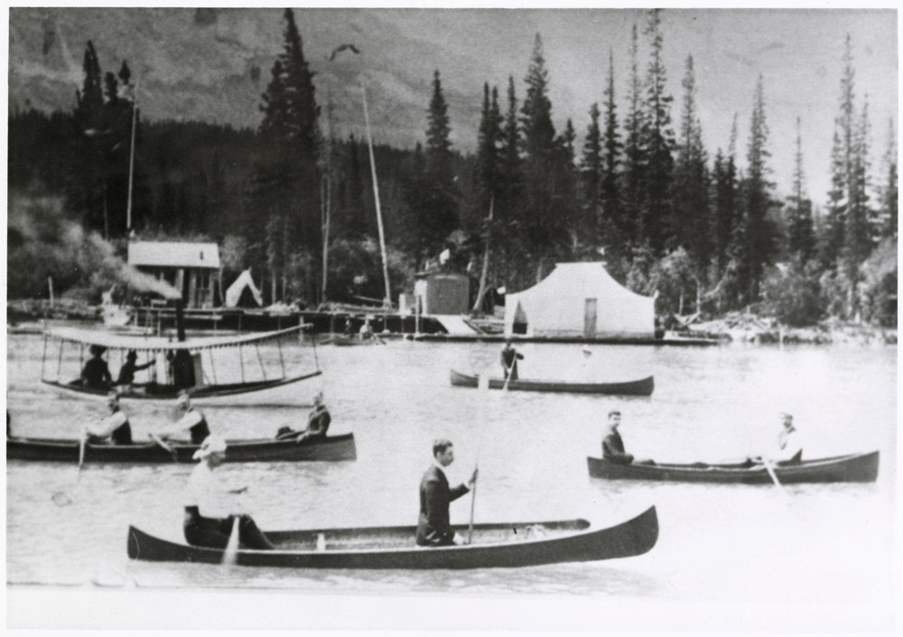
- Part Of
- Peter and Catharine Whyte fonds
- Scope & Content
- Image of various boats, mostly canoes, on the Bow River with a dock in the background
- Date Range
- 1887
- Reference Code
- V683 / III / A / 15 / PA - 687
- Description Level
- 6 / Item
- GMD
- Photograph
2 images
- Part Of
- Peter and Catharine Whyte fonds
- Description Level
- 6 / Item
- Fonds Number
- M36 / V683 / S37
- Series
- V683 / III / A / 15 : Peter and Catharine Whyte: Collected Photographs
- Sous-Fonds
- V683
- Accession Number
- .
- Reference Code
- V683 / III / A / 15 / PA - 687
- GMD
- Photograph
- Date Range
- 1887
- Physical Description
- Photograph: 1 print ; b&w.
- Scope & Content
- Image of various boats, mostly canoes, on the Bow River with a dock in the background
- Subject Access
- Banff Regatta
- Boats
- Bow River
- Buildings
- Geographic Access
- Banff
- Banff National Park
- Language
- English
- Title Source
- Title based on item
- Processing Status
- Processed
Images
This material is presented as originally created; it may contain outdated cultural descriptions and
potentially offensive content.
Read more.
Map of the Kootenay region to accompany report of Supt. S.B. Steele comanding the detachment of Mounted Police in B.C.
https://archives.whyte.org/en/permalink/catalogue21416
- Medium
- Library - Maps and blueprints (unannotated; published)
- Map
- Published Date
- 1888
- Call Number
- C10-6.2
- Published Date
- 1888
- Subjects
- Central British Columbia
- Notes
- Photostatic copy from Public Archives
- Accession Number
- 675
- Call Number
- C10-6.2
- Collection
- Archives Library
This material is presented as originally created; it may contain outdated cultural descriptions and
potentially offensive content.
Read more.
Electoral Districts for the Legislative Assembly and the Railroad System
https://archives.whyte.org/en/permalink/catalogue21500
- Medium
- Library - Maps and blueprints (unannotated; published)
- Map
- Published Date
- 1888
- Call Number
- C12-1.26
- Published Date
- 1888
- Subjects
- North West Territory
- Notes
- Photostatic copy from Public Archives
- Accession Number
- 675
- Call Number
- C12-1.26
- Collection
- Archives Library
This material is presented as originally created; it may contain outdated cultural descriptions and
potentially offensive content.
Read more.
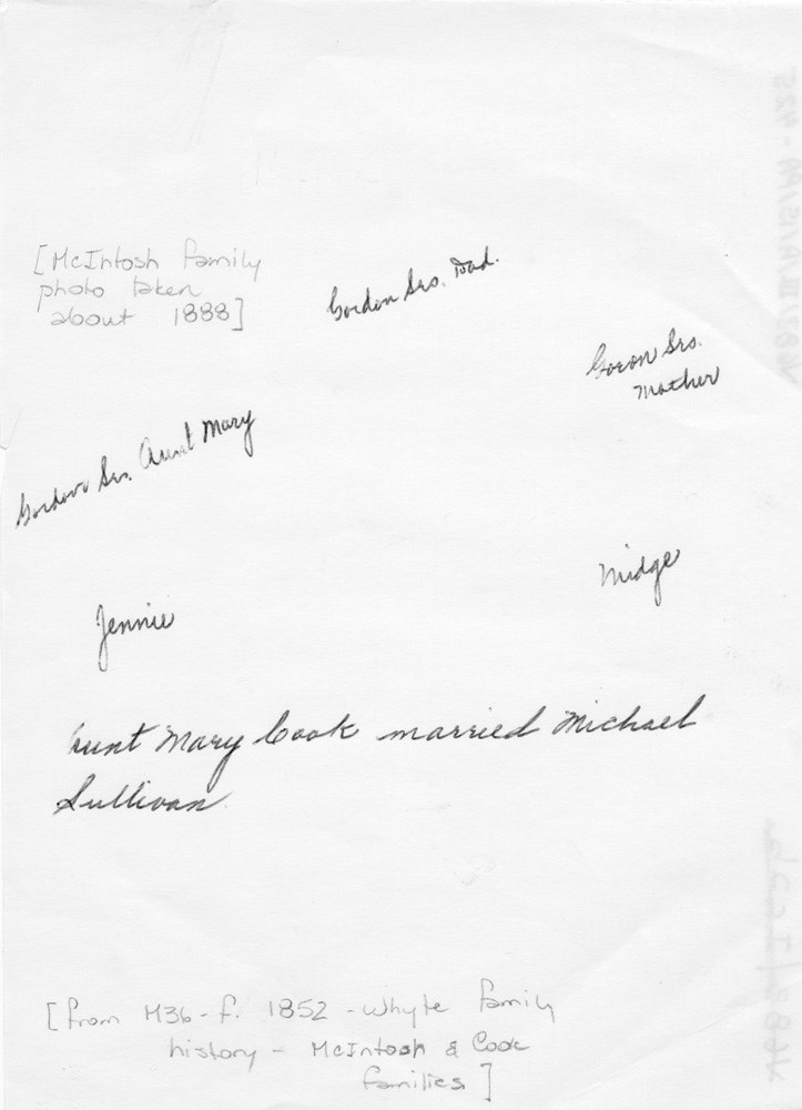
McIntosh family portrait
https://archives.whyte.org/en/permalink/descriptions53003
- Part Of
- Peter and Catharine Whyte fonds
- Scope & Content
- Image of the McIntosh family posed in a photograph studio with inscriptions on the back
- Date Range
- 1888
- Reference Code
- V683 / III / A / 15 / PA - 425
- Description Level
- 6 / Item
- GMD
- Photograph
2 images
- Part Of
- Peter and Catharine Whyte fonds
- Description Level
- 6 / Item
- Fonds Number
- M36 / V683 / S37
- Series
- V683 / III / A / 15 : Peter and Catharine Whyte: Collected Photographs
- Sous-Fonds
- V683
- Accession Number
- .
- Reference Code
- V683 / III / A / 15 / PA - 425
- GMD
- Photograph
- Date Range
- 1888
- Physical Description
- Photograph: 1 print (front and back) ; b&w.
- Scope & Content
- Image of the McIntosh family posed in a photograph studio with inscriptions on the back
- Subject Access
- Children
- Family and personal life
- Portrait
- Language
- English
- Title Source
- Title based on item
- Processing Status
- Processed
Images

This material is presented as originally created; it may contain outdated cultural descriptions and
potentially offensive content.
Read more.