Narrow Results By
- Byron Harmon fonds 3031
- Peter and Catharine Whyte fonds 733
- Luxton family fonds 209
- Vaux family fonds 186
- Elliott Barnes fonds 122
- Mary (Molly) Wright Adams fonds 110
- Tom Wilson family fonds 103
- Nicholas Morant fonds 98
- Bruno Engler fonds 68
- Mary Schaffer fonds 42
- Moore family fonds 39
- George McLean fonds 37
Map of his discoveries presented to Congress by Peter Pond
https://archives.whyte.org/en/permalink/catalogue21479
- Medium
- Library - Maps and blueprints (unannotated; published)
- Map
- Published Date
- 1785
- Author
- Pond, Peter
- Call Number
- C12-1.6
- Author
- Pond, Peter
- Published Date
- 1785
- Subjects
- Peter Pond
- Notes
- Photostatic copy from Public Archives
- Accession Number
- 675
- Call Number
- C12-1.6
- Collection
- Archives Library
This material is presented as originally created; it may contain outdated cultural descriptions and
potentially offensive content.
Read more.
Map of his discoveries presented to Congress by Peter Pond
https://archives.whyte.org/en/permalink/catalogue21480
- Medium
- Library - Maps and blueprints (unannotated; published)
- Map
- Published Date
- 1785
- Author
- Pond, Peter
- Call Number
- C12-1.6(a)
- Author
- Pond, Peter
- Published Date
- 1785
- Subjects
- Peter Pond
- Notes
- Accompanies 02.5/P77w
- Accession Number
- 400
- Call Number
- C12-1.6(a)
- Collection
- Archives Library
This material is presented as originally created; it may contain outdated cultural descriptions and
potentially offensive content.
Read more.
Map of North America
https://archives.whyte.org/en/permalink/catalogue21481
- Medium
- Library - Maps and blueprints (unannotated; published)
- Map
- Published Date
- 1785
- Author
- Pond, Peter
- Call Number
- C12-1.7
- Author
- Pond, Peter
- Published Date
- 1785
- Subjects
- Peter Pond's Map
- Notes
- Photostatic copy from Public Archives
- Accession Number
- 675
- Call Number
- C12-1.7
- Collection
- Archives Library
This material is presented as originally created; it may contain outdated cultural descriptions and
potentially offensive content.
Read more.
Map of North America
https://archives.whyte.org/en/permalink/catalogue21482
- Medium
- Library - Maps and blueprints (unannotated; published)
- Map
- Published Date
- 1785
- Author
- Pond, Peter
- Call Number
- C12-1.7(a)
- Author
- Pond, Peter
- Published Date
- 1785
- Subjects
- Peter Pond's Map
- Notes
- Photostatic copy from Public Archives
- Accession Number
- 400
- Call Number
- C12-1.7(a)
- Collection
- Archives Library
This material is presented as originally created; it may contain outdated cultural descriptions and
potentially offensive content.
Read more.
Map from Tyrell Papers
https://archives.whyte.org/en/permalink/catalogue21558
- Medium
- Library - Maps and blueprints (unannotated; published)
- Map
- Published Date
- 1785
- Call Number
- C12-1.1
- Published Date
- 1785
- Subjects
- Western Canada
- Notes
- Photostatic copy from Public Archives
- Accession Number
- 675
- Call Number
- C12-1.1
- Collection
- Archives Library
This material is presented as originally created; it may contain outdated cultural descriptions and
potentially offensive content.
Read more.
North West Territories
https://archives.whyte.org/en/permalink/catalogue21483
- Medium
- Library - Maps and blueprints (unannotated; published)
- Map
- Published Date
- 1787
- Author
- Pond, Peter
- Call Number
- C12-1.8
- Author
- Pond, Peter
- Published Date
- 1787
- Subjects
- Peter Pond's Map
- Notes
- Photostatic copy from Public Archives
- three sections
- Accession Number
- 675
- Call Number
- C12-1.8
- Collection
- Archives Library
This material is presented as originally created; it may contain outdated cultural descriptions and
potentially offensive content.
Read more.
North West Territories
https://archives.whyte.org/en/permalink/catalogue21484
- Medium
- Library - Maps and blueprints (unannotated; published)
- Map
- Published Date
- 1787
- Author
- Pond, Peter
- Call Number
- C12-1.8(d)
- Author
- Pond, Peter
- Published Date
- 1787
- Subjects
- Peter Pond's Map
- Notes
- Accompanies 02.5/P77w
- Smaller scale of maps: C12-1.8 (a) (b) (c)
- Accession Number
- 400
- Call Number
- C12-1.8(d)
- Collection
- Archives Library
This material is presented as originally created; it may contain outdated cultural descriptions and
potentially offensive content.
Read more.
Mercator's Projection showing new discoveries
https://archives.whyte.org/en/permalink/catalogue21531
- Medium
- Library - Maps and blueprints (unannotated; published)
- Map
- Published Date
- 1789
- Call Number
- C13-11.1
- Published Date
- 1789
- Subjects
- World
- Notes
- Photostatic copy from Public Archives
- C13-11.1(a), (b), (c), (d)
- Accession Number
- 675
- Call Number
- C13-11.1
- Collection
- Archives Library
This material is presented as originally created; it may contain outdated cultural descriptions and
potentially offensive content.
Read more.
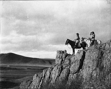
Adam Poucette? (left) [1900]
https://archives.whyte.org/en/permalink/descriptions56947
- Part Of
- Tom Wilson family fonds
- Scope & Content
- Item consists of two indiviudals on horseback, possibly Adam Poucette on the left, overlooking scenery from a rocky edge.
- Date Range
- 1900
- Reference Code
- V701 / LC - 272
- Description Level
- 6 / Item
- GMD
- Photograph
- Negative
1 image
- Part Of
- Tom Wilson family fonds
- Description Level
- 6 / Item
- Fonds Number
- M10
- V701
- Sous-Fonds
- V701
- Reference Code
- V701 / LC - 272
- GMD
- Photograph
- Negative
- Date Range
- 1900
- Physical Description
- 1 photograph : negative, 13 x 18 cm or smaller
- Scope & Content
- Item consists of two indiviudals on horseback, possibly Adam Poucette on the left, overlooking scenery from a rocky edge.
- Subject Access
- Stoney Nakoda
- Indigenous Peoples
- First Nations
- Horses
- Geographic Access
- Alberta
- Related Material
- Recognizing Relations number: RR 544
- Creator
- Wilson, Tom
- Title Source
- Information provided by Stoney Nakoda Elders during the Recognizing Relations project, an archives initiative undertaken in 2014 to identify Indigenous people in photographs held in the Whyte Museum Archives and Special Collections. Identification made by Big Horn Elders: Charlie Abraham and John Wesley
- Processing Status
- Processed
Images
This material is presented as originally created; it may contain outdated cultural descriptions and
potentially offensive content.
Read more.
[Index to Top. Sheets of Rocky Mountains]
https://archives.whyte.org/en/permalink/catalogue24641
- Medium
- Library - Maps and blueprints (unannotated; published)
- Map
- Published Date
- 1900
- Publisher
- Dept. of the Interior
- Call Number
- C3-8.1 (a)
- C3-8.1 (b)
- Publisher
- Dept. of the Interior
- Published Date
- 1900
- Scale
- (a): 25,000' to 1 inch; 1:300,000
- (b): 20,000' to 1 inch; 1:240,000
- Notes
- Photostatic copy from Public Archives
- Accession Number
- 675
- 1192
- Call Number
- C3-8.1 (a)
- C3-8.1 (b)
- Collection
- Archives Library
This material is presented as originally created; it may contain outdated cultural descriptions and
potentially offensive content.
Read more.
Map showing Yellowhead Pass route from Edmonton to Tete Jaune Cache
https://archives.whyte.org/en/permalink/catalogue24713
- Medium
- Library - Book (including soft-cover and pamphlets)
- Map
- Published Date
- 1900
- Author
- McEvoy, J.
- Publisher
- Ottawa : Geological Survey of Canada
- Call Number
- C7-1.25
- Author
- McEvoy, J.
- Responsibility
- compiled and drawn by J. McEvoy
- Publisher
- Ottawa : Geological Survey of Canada
- Published Date
- 1900
- Physical Description
- 1 map : col
- Scale
- 1:506,880
- Accession Number
- 2933
- 5670
- Call Number
- C7-1.25
- Collection
- Archives Library
This material is presented as originally created; it may contain outdated cultural descriptions and
potentially offensive content.
Read more.
Geological Survey
https://archives.whyte.org/en/permalink/catalogue24755
- Medium
- Library - Book (including soft-cover and pamphlets)
- Map
- Published Date
- 1900
- Publisher
- Dept. of the Interior, Ottawa
- Call Number
- C7-4.1
- Publisher
- Dept. of the Interior, Ottawa
- Published Date
- 1900
- Scale
- 2 miles to 1 inch
- Notes
- Dup. C8-4.2
- Accession Number
- 400
- Call Number
- C7-4.1
- Collection
- Archives Library
This material is presented as originally created; it may contain outdated cultural descriptions and
potentially offensive content.
Read more.
Geological Survey
https://archives.whyte.org/en/permalink/catalogue24773
- Medium
- Library - Book (including soft-cover and pamphlets)
- Map
- Published Date
- 1900
- Call Number
- C7-6.1(a)
- Published Date
- 1900
- Physical Description
- Colour
- Scale
- Scale: 4 miles to 1 inch
- Relief: Bench marks
- Subjects
- New Brunswick - Andover Sheet
- Accession Number
- 400
- Call Number
- C7-6.1(a)
- Collection
- Archives Library
This material is presented as originally created; it may contain outdated cultural descriptions and
potentially offensive content.
Read more.
[New Brunswick - Fredericton Sheet]
https://archives.whyte.org/en/permalink/catalogue24774
- Medium
- Library - Book (including soft-cover and pamphlets)
- Map
- Published Date
- 1900
- Publisher
- Geological Survey
- Call Number
- C7-6.1(b)
- Publisher
- Geological Survey
- Published Date
- 1900
- Scale
- Relief: Bench marks
- Scale: 4 miles to 1 inch
- Subjects
- New Brunswick - Frederiction Sheet
- Accession Number
- 400
- Call Number
- C7-6.1(b)
- Collection
- Archives Library
This material is presented as originally created; it may contain outdated cultural descriptions and
potentially offensive content.
Read more.
Iron ores and other minerals
https://archives.whyte.org/en/permalink/catalogue24783
- Medium
- Library - Book (including soft-cover and pamphlets)
- Map
- Published Date
- 1900
- Publisher
- Dept. of Crown Lands of Ontario. Geological Survey of Canada
- Call Number
- C7-6.10
- Publisher
- Dept. of Crown Lands of Ontario. Geological Survey of Canada
- Published Date
- 1900
- Physical Description
- Colour
- Scale
- 1:126,720
- Accession Number
- 400
- Call Number
- C7-6.10
- Collection
- Archives Library
This material is presented as originally created; it may contain outdated cultural descriptions and
potentially offensive content.
Read more.
Maps of exploration survey of divide between Great Slave Lake and Hudson Bay
https://archives.whyte.org/en/permalink/catalogue21400
- Medium
- Library - Maps and blueprints (unannotated; published)
- Map
- Published Date
- 1900
- Publisher
- Districts of MacKenzie and Keewatin, Dominion of Canada
- Call Number
- C8-3.3(a-v)
- Publisher
- Districts of MacKenzie and Keewatin, Dominion of Canada
- Published Date
- 1900
- Notes
- See: Sheets 1-22 (no. 11 missing)
- Accession Number
- 1248
- Call Number
- C8-3.3(a-v)
- Collection
- Archives Library
This material is presented as originally created; it may contain outdated cultural descriptions and
potentially offensive content.
Read more.
Showing rivers and Indian trails
https://archives.whyte.org/en/permalink/catalogue21450
- Medium
- Library - Maps and blueprints (unannotated; published)
- Map
- Published Date
- 1900
- Call Number
- C3-8.22
- Published Date
- 1900
- Subjects
- Rocky Mountains (2 Sections)
- Notes
- Photostatic copy from Public Archives
- Accession Number
- 675
- Call Number
- C3-8.22
- Collection
- Archives Library
This material is presented as originally created; it may contain outdated cultural descriptions and
potentially offensive content.
Read more.
Drainage Patterns
https://archives.whyte.org/en/permalink/catalogue21492
- Medium
- Library - Maps and blueprints (unannotated; published)
- Map
- Published Date
- 1900
- Call Number
- C12-1.17
- Published Date
- 1900
- Subjects
- Rocky Mountains
- Notes
- 2 sections
- Photostatic copy from Public Archives
- Accession Number
- 675
- Call Number
- C12-1.17
- Collection
- Archives Library
This material is presented as originally created; it may contain outdated cultural descriptions and
potentially offensive content.
Read more.
Map showing Yellowhead Pass route from Edmonton to Tete-Jaune Cache
https://archives.whyte.org/en/permalink/catalogue23367
- Medium
- Library - Maps and blueprints (unannotated; published)
- Map
- Published Date
- 1900
- Publisher
- Geological Survey
- Call Number
- C6-3.3
- Publisher
- Geological Survey
- Published Date
- 1900
- Physical Description
- Colour
- Scale
- Scale: 8 miles to 1 inch
- Relief: Contour interval approx. 1000 ft.
- Subjects
- Yellowhead Pass
- Accession Number
- 1000
- Call Number
- C6-3.3
- Collection
- Archives Library
This material is presented as originally created; it may contain outdated cultural descriptions and
potentially offensive content.
Read more.
Map showing Yellowhead Pass route from Edmonton to Tete-Jaune Cache
https://archives.whyte.org/en/permalink/catalogue24300
- Medium
- Library - Maps and blueprints (unannotated; published)
- Map
- Published Date
- 1900
- Publisher
- Geological Survey
- Call Number
- C6-3.3
- Publisher
- Geological Survey
- Published Date
- 1900
- Physical Description
- Colour
- Scale
- Scale: 8 miles to 1 inch
- Relief: Contour interval approx. 1000 ft.
- Subjects
- Yellowhead Pass
- Accession Number
- 1000
- Call Number
- C6-3.3
- Collection
- Archives Library
This material is presented as originally created; it may contain outdated cultural descriptions and
potentially offensive content.
Read more.