Narrow Results By
- Luxton family fonds 46
- George McLean fonds 37
- Nicholas Morant fonds 34
- Kidney family fonds 21
- Trail Riders of the Canadian Rockies fonds 16
- Bruno Engler fonds 9
- Archives General File Collection 8
- Lawrence Grassi fonds 8
- Ron Duke fonds 7
- Dorothy Cranstone fonds 6
- Dorothy Wardle fonds 6
- Alpine Club of Canada fonds 5
Survey and discovery of Oregon Territory|Survey of Athabaska Lake, Slave River|Route of Sir. A. Mackenzie in 1792|Survey of Fraser River by J. Stewart|Survey of North West Company by D. Thompson
https://archives.whyte.org/en/permalink/catalogue21475
- Medium
- Library - Maps and blueprints (unannotated; published)
- Map
- Published Date
- 1814
- Call Number
- C12-1.2
- Published Date
- 1814
- Subjects
- Western Canada
- Notes
- Photostatic copy from Public Archives
- eight sections
- Accession Number
- 675
- Call Number
- C12-1.2
- Collection
- Archives Library
This material is presented as originally created; it may contain outdated cultural descriptions and
potentially offensive content.
Read more.
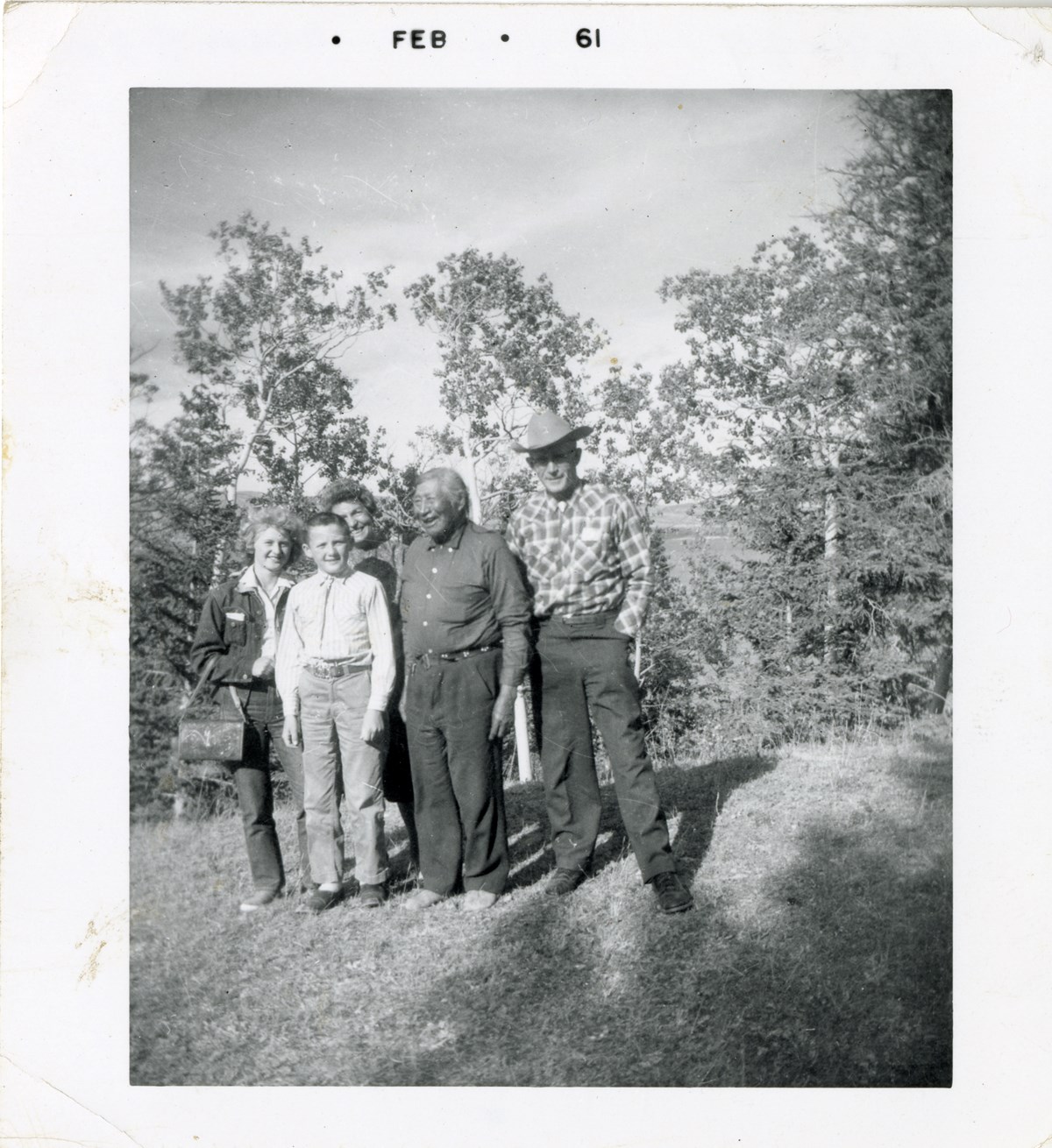
[George McLean (Tatâga Mânî) (Walking Buffalo) second on the right]
https://archives.whyte.org/en/permalink/descriptions57095
- Part Of
- George McLean fonds
- Scope & Content
- Item consists of photograph print of a group photo with George McLean (Tatâga Mânî) (Walking Buffalo) stood second on the right.
- Date Range
- 1960
- Reference Code
- V422 / PA - 64
- Description Level
- 6 / Item
- GMD
- Photograph print
- Photograph
1 image
- Part Of
- George McLean fonds
- Description Level
- 6 / Item
- Fonds Number
- M42
- V422
- Series
- II. Photographs
- Sous-Fonds
- V422
- Reference Code
- V422 / PA - 64
- Date Range
- 1960
- Physical Description
- 1 photograph: print
- Scope & Content
- Item consists of photograph print of a group photo with George McLean (Tatâga Mânî) (Walking Buffalo) stood second on the right.
- Name Access
- McLean, George
- Subject Access
- Indigenous Peoples
- Stoney Nakoda
- First Nations
- Portrait
- Geographic Access
- Alberta
- Related Material
- Recognizing Relations number: RR 475
- Title Source
- Information provided by Stoney Nakoda Elders during the Recognizing Relations project, an archives initiative undertaken in 2014 to identify Indigenous people in photographs held in the Whyte Museum Archives and Special Collections.
- Processing Status
- Processed
Images
This material is presented as originally created; it may contain outdated cultural descriptions and
potentially offensive content.
Read more.
[Exshaw-Golden] Sheets 1 and 2, Photogeological interpretation
https://archives.whyte.org/en/permalink/catalogue24720
- Medium
- Library - Book (including soft-cover and pamphlets)
- Map
- Published Date
- 1960
- Publisher
- Hunting Survey Corp. Ltd. Calgary
- Call Number
- C7-2.6
- Publisher
- Hunting Survey Corp. Ltd. Calgary
- Published Date
- 1960
- Physical Description
- 1 map : col
- Scale
- Relief: Contour interval 1000'
- Accession Number
- 673
- 2815
- Call Number
- C7-2.6
- Collection
- Archives Library
This material is presented as originally created; it may contain outdated cultural descriptions and
potentially offensive content.
Read more.
Geological and Tectonic map
https://archives.whyte.org/en/permalink/catalogue24757
- Medium
- Library - Book (including soft-cover and pamphlets)
- Map
- Published Date
- 1960
- Publisher
- Alberta Society of Petroleum Geologists
- Call Number
- C7-4.3
- Publisher
- Alberta Society of Petroleum Geologists
- Published Date
- 1960
- Physical Description
- Colour
- Scale
- 1:7,500,000
- Subjects
- Arctic
- Accession Number
- 673
- Call Number
- C7-4.3
- Collection
- Archives Library
This material is presented as originally created; it may contain outdated cultural descriptions and
potentially offensive content.
Read more.
[South America]
https://archives.whyte.org/en/permalink/catalogue24831
- Medium
- Library - Maps and blueprints (unannotated; published)
- Map
- Published Date
- 1960
- Publisher
- National Geographic Society
- Call Number
- C13-3.3
- Publisher
- National Geographic Society
- Published Date
- 1960
- Scale
- Scale: 192 miles to 1 inch
- Relief: Bench marks
- Subjects
- South America
- Accession Number
- 495
- Call Number
- C13-3.3
- Collection
- Archives Library
This material is presented as originally created; it may contain outdated cultural descriptions and
potentially offensive content.
Read more.
[Ashnola 92H/1 East, B.C.]
https://archives.whyte.org/en/permalink/catalogue23452
- Medium
- Library - Maps and blueprints (unannotated; published)
- Map
- Published Date
- 1960
- Publisher
- Army Survey Establishment
- Call Number
- NTS
- 92H/1E
- Publisher
- Army Survey Establishment
- Published Date
- 1960
- Physical Description
- 1 map : col
- Scale
- Scale: 1:50,000
- Relief: Contour interval 100 ft.
- Subjects
- Ashnola
- British Columbia
- Notes
- National Topographic System
- Accession Number
- 7000
- Call Number
- NTS
- 92H/1E
- Collection
- Archives Library
This material is presented as originally created; it may contain outdated cultural descriptions and
potentially offensive content.
Read more.
[Ashnola 92H/1 West, B.C.]
https://archives.whyte.org/en/permalink/catalogue23453
- Medium
- Library - Maps and blueprints (unannotated; published)
- Map
- Published Date
- 1960
- Publisher
- Army Survey Establishment
- Call Number
- NTS
- 92H/1W
- Publisher
- Army Survey Establishment
- Published Date
- 1960
- Physical Description
- 1 map : col
- Scale
- Scale: 1:50,000
- Relief: Contour interval 100 ft.
- Subjects
- Ashnola
- British Columbia
- Notes
- National Topographic System
- Accession Number
- 7000
- Call Number
- NTS
- 92H/1W
- Collection
- Archives Library
This material is presented as originally created; it may contain outdated cultural descriptions and
potentially offensive content.
Read more.
[Barrier Mountain 820/12 East, Alberta]
https://archives.whyte.org/en/permalink/catalogue23484
- Medium
- Library - Maps and blueprints (unannotated; published)
- Map
- Published Date
- 1960
- Publisher
- Dept. of Mines and Technical Surveys
- Call Number
- NTS
- 820/12E
- Publisher
- Dept. of Mines and Technical Surveys
- Published Date
- 1960
- Physical Description
- 1 map : col
- Scale
- Scale: 1:50,000
- Relief: Contour interval 100'
- Subjects
- Barrier Mountain
- Alberta
- Notes
- National Topographic System
- Accession Number
- 6283
- Call Number
- NTS
- 820/12E
- Collection
- Archives Library
This material is presented as originally created; it may contain outdated cultural descriptions and
potentially offensive content.
Read more.
[Barrier Mountain 820/12 West, Alberta]
https://archives.whyte.org/en/permalink/catalogue23485
- Medium
- Library - Maps and blueprints (unannotated; published)
- Map
- Published Date
- 1960
- Publisher
- Dept. of Mines and Technical Surveys
- Call Number
- NTS
- 820/12W
- Publisher
- Dept. of Mines and Technical Surveys
- Published Date
- 1960
- Physical Description
- 1 map : col
- Scale
- Scale: 1:50,000
- Relief: Contour interval 100'
- Subjects
- Barrier Mountain
- Alberta
- Notes
- National Topographic System
- Accession Number
- 6283
- Call Number
- NTS
- 820/12W
- Collection
- Archives Library
This material is presented as originally created; it may contain outdated cultural descriptions and
potentially offensive content.
Read more.
[Beaver Mines 82G/8 East, Alberta]
https://archives.whyte.org/en/permalink/catalogue23490
- Medium
- Library - Maps and blueprints (unannotated; published)
- Map
- Published Date
- 1960
- Publisher
- Dept of Mines and Techinical Surveys
- Call Number
- NTS
- 82G/8E
- Publisher
- Dept of Mines and Techinical Surveys
- Published Date
- 1960
- Scale
- Scale: 1 : 50,000
- Relief: Contour interval 100'
- Subjects
- Beaver Mines
- East Alberta
- Notes
- National Topographic System
- Call Number
- NTS
- 82G/8E
- Collection
- Archives Library
This material is presented as originally created; it may contain outdated cultural descriptions and
potentially offensive content.
Read more.
[Beaver Mines 82G/8 West, Alberta-B.C.]
https://archives.whyte.org/en/permalink/catalogue23491
- Medium
- Library - Maps and blueprints (unannotated; published)
- Map
- Published Date
- 1960
- Publisher
- Dept of Mines and Techinical Surveys
- Call Number
- NTS
- 82G/8W
- Publisher
- Dept of Mines and Techinical Surveys
- Published Date
- 1960
- Physical Description
- 1 map : col
- Scale
- Scale: 1:50,000
- Relief: Contour interval 100'
- Subjects
- Beaver Mines
- West Alberta-B.C.
- Notes
- National Topographic System
- Call Number
- NTS
- 82G/8W
- Collection
- Archives Library
This material is presented as originally created; it may contain outdated cultural descriptions and
potentially offensive content.
Read more.
[Blue Creek 83E/7 East, Alta.]
https://archives.whyte.org/en/permalink/catalogue23503
- Medium
- Library - Maps and blueprints (unannotated; published)
- Map
- Published Date
- 1960
- Publisher
- Dept. of Mines and Techinical Surveys
- Call Number
- NTS
- 83E/7E
- Publisher
- Dept. of Mines and Techinical Surveys
- Published Date
- 1960
- Physical Description
- 1 map : col
- Scale
- Scale: 1: 50,000
- Relief: Contour Interval 100 feet
- Subjects
- Blue Creek
- Eastern Alberta
- Notes
- National Topographic System
- Accession Number
- 3000
- Call Number
- NTS
- 83E/7E
- Collection
- Archives Library
This material is presented as originally created; it may contain outdated cultural descriptions and
potentially offensive content.
Read more.
[Blue Creek 83E/7 West, Alta.]
https://archives.whyte.org/en/permalink/catalogue23504
- Medium
- Library - Maps and blueprints (unannotated; published)
- Map
- Published Date
- 1960
- Publisher
- Dept. of Mines and Techinical Surveys
- Call Number
- NTS
- 83E/7W
- Publisher
- Dept. of Mines and Techinical Surveys
- Published Date
- 1960
- Physical Description
- 1 map : col
- Scale
- Scale: 1:50,000
- Relief: Contour Interval 100 ft.
- Subjects
- Blue Creek
- Western Alberta
- Notes
- National Topographic System
- Accession Number
- 3000
- Call Number
- NTS
- 83E/7W
- Collection
- Archives Library
This material is presented as originally created; it may contain outdated cultural descriptions and
potentially offensive content.
Read more.
[Cheakamus River, B.C.]
https://archives.whyte.org/en/permalink/catalogue23548
- Medium
- Library - Maps and blueprints (unannotated; published)
- Map
- Published Date
- 1960
- Publisher
- Dept. of Lands and Forests
- Call Number
- NTS
- 92G/14E
- Publisher
- Dept. of Lands and Forests
- Published Date
- 1960
- Physical Description
- 1 map : col
- Scale
- Scale: 1:50,000
- Relief: Contour Interval 100'
- Subjects
- Cheakamus River
- British Columbia
- Notes
- National Topographic System
- Accession Number
- 1045
- Call Number
- NTS
- 92G/14E
- Collection
- Archives Library
This material is presented as originally created; it may contain outdated cultural descriptions and
potentially offensive content.
Read more.
[Cheakamus River, B.C.]
https://archives.whyte.org/en/permalink/catalogue23549
- Medium
- Library - Maps and blueprints (unannotated; published)
- Map
- Published Date
- 1960
- Publisher
- Dept. of Lands and Forests
- Call Number
- NTS
- 92G/14W
- Publisher
- Dept. of Lands and Forests
- Published Date
- 1960
- Physical Description
- 1 map : col
- Scale
- Scale: 1:50,000
- Relief: Contour Interval 100 feet
- Subjects
- Cheakamus River
- British Columbia
- Notes
- National Topographic System
- Accession Number
- 1045
- Call Number
- NTS
- 92G/14W
- Collection
- Archives Library
This material is presented as originally created; it may contain outdated cultural descriptions and
potentially offensive content.
Read more.
[Elko 82G/6E, B.C.]
https://archives.whyte.org/en/permalink/catalogue23602
- Medium
- Library - Maps and blueprints (unannotated; published)
- Map
- Published Date
- 1960
- Publisher
- Dept. of Mines and Technical Surveys
- Call Number
- NTS
- 82G/6E
- Publisher
- Dept. of Mines and Technical Surveys
- Published Date
- 1960
- Physical Description
- 1 map : col
- Scale
- Scale: 1:50,000
- Relief: Contour interval 100'
- Subjects
- Elko
- British Columbia
- Notes
- National Topographic System
- Call Number
- NTS
- 82G/6E
- Collection
- Archives Library
This material is presented as originally created; it may contain outdated cultural descriptions and
potentially offensive content.
Read more.
[Elko 82G/6 West, B.C.]
https://archives.whyte.org/en/permalink/catalogue23603
- Medium
- Library - Maps and blueprints (unannotated; published)
- Map
- Published Date
- 1960
- Publisher
- Dept. of Minesand Technical Surveys
- Call Number
- NTS
- 82G/6W
- Publisher
- Dept. of Minesand Technical Surveys
- Published Date
- 1960
- Physical Description
- 1 map : col
- Scale
- Scale: 1:50,000
- Relief: Contour interval 100'
- Subjects
- Elko
- British Columbia
- Notes
- National Topographic System
- Call Number
- NTS
- 82G/6W
- Collection
- Archives Library
This material is presented as originally created; it may contain outdated cultural descriptions and
potentially offensive content.
Read more.
[Fording River 82J/2 East, B.C.-Alberta]
https://archives.whyte.org/en/permalink/catalogue23619
- Medium
- Library - Maps and blueprints (unannotated; published)
- Map
- Published Date
- 1960
- Publisher
- Dept. of Mines and Technical Surveys
- Call Number
- NTS
- 82J/2E
- Publisher
- Dept. of Mines and Technical Surveys
- Published Date
- 1960
- Physical Description
- 1 map : col
- Scale
- Scale: 1:50,000
- Relief: Contour interval 100'
- Subjects
- Fording River
- British Columbia/Alberta
- Notes
- National Topographic System
- Call Number
- NTS
- 82J/2E
- Collection
- Archives Library
This material is presented as originally created; it may contain outdated cultural descriptions and
potentially offensive content.
Read more.
[Fording River 82J/2W, B.C.-Alberta]
https://archives.whyte.org/en/permalink/catalogue23620
- Medium
- Library - Maps and blueprints (unannotated; published)
- Map
- Published Date
- 1960
- Publisher
- Dept. of Mines and Technical Surveys
- Call Number
- NTS
- 82J/2W
- Publisher
- Dept. of Mines and Technical Surveys
- Published Date
- 1960
- Physical Description
- 1 map : col
- Scale
- Scale: 1:50,000
- Relief: Contour interval 100'
- Subjects
- Fording River 82J/2W, B.C.-Alberta
- Notes
- National Topographic System
- Call Number
- NTS
- 82J/2W
- Collection
- Archives Library
This material is presented as originally created; it may contain outdated cultural descriptions and
potentially offensive content.
Read more.
[Job Creek 83 C/7 East - Alberta]
https://archives.whyte.org/en/permalink/catalogue23683
- Medium
- Library - Maps and blueprints (unannotated; published)
- Map
- Published Date
- 1960
- Publisher
- Dept. of Mines and Technical Surveys
- Call Number
- NTS
- 83C/7E
- Publisher
- Dept. of Mines and Technical Surveys
- Published Date
- 1960
- Physical Description
- Colour
- Scale
- Scale: 1:50,000
- Relief: Contour interval 100'
- Subjects
- Job Creek 83 C/7 East - Alberta
- Notes
- National Topographic System
- Accession Number
- 717
- Call Number
- NTS
- 83C/7E
- Collection
- Archives Library
This material is presented as originally created; it may contain outdated cultural descriptions and
potentially offensive content.
Read more.