Narrow Results By
Map showing Yellowhead Pass route from Edmonton to Tete-Jaune Cache
https://archives.whyte.org/en/permalink/catalogue24300
- Medium
- Library - Maps and blueprints (unannotated; published)
- Map
- Published Date
- 1900
- Publisher
- Geological Survey
- Call Number
- C6-3.3
- Publisher
- Geological Survey
- Published Date
- 1900
- Physical Description
- Colour
- Scale
- Scale: 8 miles to 1 inch
- Relief: Contour interval approx. 1000 ft.
- Subjects
- Yellowhead Pass
- Accession Number
- 1000
- Call Number
- C6-3.3
- Collection
- Archives Library
This material is presented as originally created; it may contain outdated cultural descriptions and
potentially offensive content.
Read more.
[Yukon District] Klondike Gold Fields
https://archives.whyte.org/en/permalink/catalogue24373
- Medium
- Library - Maps and blueprints (unannotated; published)
- Map
- Published Date
- 1900
- Publisher
- Dept. of the Interior
- Call Number
- C8-2.5
- Publisher
- Dept. of the Interior
- Published Date
- 1900
- Scale
- Scale: 2 miles - 1 inch
- Subjects
- Yukon District
- Notes
- Duplicate: C7-4.1
- Accession Number
- 400
- Call Number
- C8-2.5
- Collection
- Archives Library
This material is presented as originally created; it may contain outdated cultural descriptions and
potentially offensive content.
Read more.
Showing part of the Summit Range of the Canadian Rocky Mountains
https://archives.whyte.org/en/permalink/catalogue24615
- Medium
- Library - Maps and blueprints (unannotated; published)
- Map
- Published Date
- 1900
- Author
- Wilcox, Walter D.
- Call Number
- C3-2.1a
- Author
- Wilcox, Walter D.
- Responsibility
- Surveyed and drawn by Walter D. Wilcox
- Published Date
- 1900
- Physical Description
- Colour
- Scale
- Scale: 1 1/2 inch = 1 mile
- Relief: Contour interval 100'
- Subjects
- Lake Louise
- Notes
- Photostatic copy
- Accession Number
- 400
- 675
- Call Number
- C3-2.1a
- Collection
- Archives Library
This material is presented as originally created; it may contain outdated cultural descriptions and
potentially offensive content.
Read more.
[Index to Top. Sheets of Rocky Mountains]
https://archives.whyte.org/en/permalink/catalogue24641
- Medium
- Library - Maps and blueprints (unannotated; published)
- Map
- Published Date
- 1900
- Publisher
- Dept. of the Interior
- Call Number
- C3-8.1 (a)
- C3-8.1 (b)
- Publisher
- Dept. of the Interior
- Published Date
- 1900
- Scale
- (a): 25,000' to 1 inch; 1:300,000
- (b): 20,000' to 1 inch; 1:240,000
- Notes
- Photostatic copy from Public Archives
- Accession Number
- 675
- 1192
- Call Number
- C3-8.1 (a)
- C3-8.1 (b)
- Collection
- Archives Library
This material is presented as originally created; it may contain outdated cultural descriptions and
potentially offensive content.
Read more.
Map showing Yellowhead Pass route from Edmonton to Tete Jaune Cache
https://archives.whyte.org/en/permalink/catalogue24713
- Medium
- Library - Book (including soft-cover and pamphlets)
- Map
- Published Date
- 1900
- Author
- McEvoy, J.
- Publisher
- Ottawa : Geological Survey of Canada
- Call Number
- C7-1.25
- Author
- McEvoy, J.
- Responsibility
- compiled and drawn by J. McEvoy
- Publisher
- Ottawa : Geological Survey of Canada
- Published Date
- 1900
- Physical Description
- 1 map : col
- Scale
- 1:506,880
- Accession Number
- 2933
- 5670
- Call Number
- C7-1.25
- Collection
- Archives Library
This material is presented as originally created; it may contain outdated cultural descriptions and
potentially offensive content.
Read more.
Geological Survey
https://archives.whyte.org/en/permalink/catalogue24755
- Medium
- Library - Book (including soft-cover and pamphlets)
- Map
- Published Date
- 1900
- Publisher
- Dept. of the Interior, Ottawa
- Call Number
- C7-4.1
- Publisher
- Dept. of the Interior, Ottawa
- Published Date
- 1900
- Scale
- 2 miles to 1 inch
- Notes
- Dup. C8-4.2
- Accession Number
- 400
- Call Number
- C7-4.1
- Collection
- Archives Library
This material is presented as originally created; it may contain outdated cultural descriptions and
potentially offensive content.
Read more.
Geological Survey
https://archives.whyte.org/en/permalink/catalogue24773
- Medium
- Library - Book (including soft-cover and pamphlets)
- Map
- Published Date
- 1900
- Call Number
- C7-6.1(a)
- Published Date
- 1900
- Physical Description
- Colour
- Scale
- Scale: 4 miles to 1 inch
- Relief: Bench marks
- Subjects
- New Brunswick - Andover Sheet
- Accession Number
- 400
- Call Number
- C7-6.1(a)
- Collection
- Archives Library
This material is presented as originally created; it may contain outdated cultural descriptions and
potentially offensive content.
Read more.
[New Brunswick - Fredericton Sheet]
https://archives.whyte.org/en/permalink/catalogue24774
- Medium
- Library - Book (including soft-cover and pamphlets)
- Map
- Published Date
- 1900
- Publisher
- Geological Survey
- Call Number
- C7-6.1(b)
- Publisher
- Geological Survey
- Published Date
- 1900
- Scale
- Relief: Bench marks
- Scale: 4 miles to 1 inch
- Subjects
- New Brunswick - Frederiction Sheet
- Accession Number
- 400
- Call Number
- C7-6.1(b)
- Collection
- Archives Library
This material is presented as originally created; it may contain outdated cultural descriptions and
potentially offensive content.
Read more.
Iron ores and other minerals
https://archives.whyte.org/en/permalink/catalogue24783
- Medium
- Library - Book (including soft-cover and pamphlets)
- Map
- Published Date
- 1900
- Publisher
- Dept. of Crown Lands of Ontario. Geological Survey of Canada
- Call Number
- C7-6.10
- Publisher
- Dept. of Crown Lands of Ontario. Geological Survey of Canada
- Published Date
- 1900
- Physical Description
- Colour
- Scale
- 1:126,720
- Accession Number
- 400
- Call Number
- C7-6.10
- Collection
- Archives Library
This material is presented as originally created; it may contain outdated cultural descriptions and
potentially offensive content.
Read more.
- Part Of
- Vaux family fonds
- Date Range
- 1900
- Reference Code
- V653 / NA - 128 to 377
- Description Level
- 4 / Sub-series
- GMD
- Photograph
- Negative
- Part Of
- Vaux family fonds
- Description Level
- 4 / Sub-series
- Fonds Number
- V653
- Series
- I. Photography
- Sous-Fonds
- V653
- Reference Code
- V653 / NA - 128 to 377
- GMD
- Photograph
- Negative
- Date Range
- 1900
- Physical Description
- 250 photographs : negatives; film, 4x5" and 6.5x8.5"
- Access Restrictions
- Access by appointment only
- Title Source
- Title based on contents of file
- Content Details
- ITEM LIST OF NEGATIVES (V653/NA - 128 to 377):
- [Note: Repeat descriptions have been combined by the archivist]
- 128-134 North Bend & Victoria -- [1900?] -- [Includes B.C. legislature buildings; Chinese man carrying baskets; Indigenous drying rack?; Indigenous burial platform?; elderly Indigenous man; Indigenous people on railroad track?; man crossing unidentified stream]
- 135-142 Glacier & west -- [1900?] -- [Unidentified mountains]
- 143-144 Glacier & west -- [1900?] -- [Illecillewaet Glacier]
- 145-150 East of Glacier / Dr. Sharples -- [1900?] -- [Unidentified scenes]
- 151-155 East of Glacier -- [1900?] -- [Kicking Horse River, Mount Burgess, Lake Louise, Mount Lefroy]
- 156-158 East of Glacier / Dr. Sharples -- [1900?] -- [The Mitre and Abbot Pass, Abbot Pass]
- 159 East of Glacier -- [1900?] -- [Group of six alpinists on Victoria Glacier?]
- 160-161 East of Glacier / Dr. Sharples -- [1900?] -- [Includes train on unidentified bridge, ladies eating]
- 162-166 East of Glacier -- [1900?] -- [Includes teepees and fence, ladies and children, people on station platform]
- 167-172 Lake Marion -- 7/1900 -- [Includes unidentified mountains, Mount Sir Donald?]
- 173-180 On the Great Glacier -- 1900 -- [Includes George Vaux Jr. & Edward Feuz Sr., Mary M. Vaux, unidentified Swiss Guide/s, unidentified men, edge of crevasse]
- 181 [Mary M. Vaux with Swiss guide crossing snowbridge over crevasse] -- [1900?]
- 182 [Mary M. Vaux and Swiss guide roped together on unidentified mountain] -- [1900?]
- 183-191 On the Great Glacier -- 1900 -- [Includes views of people, crevasses and seracs, surroundings]
- 192-193 Asulkan trip -- 7/4/00 -- [Includes views of people, Swiss Guides, unidentified mountains]
- 194 [Unidentified forest scene in snow] / Mary Vaux
- 195-225 Asulkan trip -- 7/4/00 -- [Includes views of people, Swiss Guides, unidentified mountains]
- 226-233 R.R. between Field & Leanchoil -- 1900
- 234-255 Mount Stephen -- 1900 -- [Mainly views of unidentified mountains]
- 256 Emerald Lake -- [1900?] -- [Log cabins]
- 257 Emerald Lake -- 1900 -- [Man and woman in front of log cabin]
- 258 [Group of people at cabins on shore of Emerald Lake?] -- [1900?]
- 259 [Swiss guide opening can with ice axe on porch of cabin at Emerald Lake?] -- [1900?]
- 260 Emerald Lake -- [1900?] -- [Man on pier]
- 261-267 Wapta Fall -- [1900?] -- [Takakkaw Falls]
- 268-269 Wapta Fall -- [1900?] -- [Yoho Glacier?]
- 270-274 Field, B.C. -- 1900 -- [Unidentified mountains]
- 275 Field, B.C. -- 1900 -- [Kicking Horse River from above]
- 276 Field, B.C. -- 1900 -- [Man on rockslide]
- 277-288 Kicking Horse Canon -- 1900
- 289-291 Kicking Horse Canon -- 1900 -- [Includes trains]
- 292-304 On CPR 1900 From Field east -- 1900 -- [Includes railway conductors and passengers, Kicking Horse River, burnt timber beside railroad, unidentified mountains, Mt. Temple from railroad, Castle Mtn. and remains of Silver City]
- 305-307 Mt. Temple -- 1900 -- [From Bow River]
- 308 [Mt. Temple from Bow River] -- [1900?]
- 309-310 Victoria Glacier -- 1900
- 311 [Group of alpinists above Lake Louise near Victoria Glacier] -- [1900?]
- 312-326 Victoria Glacier -- 1900 -- [Includes views of Victoria Glacier, Lake Louise from Victoria Glacier, alpinists on and near glacier, "Glacier table"]
- 327 [Man on "glacier table" near Victoria Glacier] -- [1900?]
- 328 Victoria Glacier [Group of six people Victoria Glacier including Swiss guide and cameraman] -- 1900 -- [Photograph by Mary Vaux, July 24, 1900]
- 329 [Group of six people on Victoria Glacier including Swiss guide and cameraman] -- [July 24, 1900]
- 330 Victoria Glacier -- 1900 -- [Caleb Cresson with fossilized rock, July 24, 1900]
- 331 Victoria Glacier -- 1900 -- [Alpinists eating near marker boulder "XV '99", July 24, 1900]
- 332 [Man beside marker boulder "XV '99" near Victoria Glacier] -- [July 24, 1900]
- 333-337 Victoria Glacier -- 1900 -- [Mount Lefroy?, Abbot Pass, The Mitre and Abbot Pass]
- 338 [Abbot Pass] -- [1900?]
- 339 Victoria Glacier -- 1900 -- [Alpinists on Victoria Glacier]
- 340 [Unidentified river] -- [1900?]
- 341 [Unidentified lake with island] -- [1900?]
- 342 [Unidentified mountains and waterfall] / Mary Vaux
- 343 [Alpinists looking at view from unidentified mountain]
- 344 [Unidentified moraine and lake]
- 345 [Unidentified mountains and river]
- 346 [Unidentified glacier]
- 347 [Conductor and dog on station platform] -- [1900?]
- 348-349 [Man and dog on station platform] -- 1900
- 350-367 Banff -- 1900 -- [Views pertain to man with dog on station platform, Mount Rundle, Bow River, Cascade Mountain, Bow River and boathouse, Mount Edith, Basin pool, Cave and Basin caretaker's house, NWMP barracks, Banff Springs Hotel, Banff Avenue, Sulphur Mountain, road west of Banff]
- 368-372 On CPR 1900 Ottawa N shore of Lake Superior -- 1900
- 373-374 [Market] Montreal & Quebec -- 9/ /00 -- [Market]
- 375 R.R. bridge -- 9/ /00 -- [Montreal & Quebec]
- 376 Montreal & Quebec -- 9/ /00 -- [R.R. bridge]
- 377 [Bridge] Montreal & Quebec -- 9/ /00
- Processing Status
- Processed
This material is presented as originally created; it may contain outdated cultural descriptions and
potentially offensive content.
Read more.
Maps of exploration survey of divide between Great Slave Lake and Hudson Bay
https://archives.whyte.org/en/permalink/catalogue21400
- Medium
- Library - Maps and blueprints (unannotated; published)
- Map
- Published Date
- 1900
- Publisher
- Districts of MacKenzie and Keewatin, Dominion of Canada
- Call Number
- C8-3.3(a-v)
- Publisher
- Districts of MacKenzie and Keewatin, Dominion of Canada
- Published Date
- 1900
- Notes
- See: Sheets 1-22 (no. 11 missing)
- Accession Number
- 1248
- Call Number
- C8-3.3(a-v)
- Collection
- Archives Library
This material is presented as originally created; it may contain outdated cultural descriptions and
potentially offensive content.
Read more.
Showing rivers and Indian trails
https://archives.whyte.org/en/permalink/catalogue21450
- Medium
- Library - Maps and blueprints (unannotated; published)
- Map
- Published Date
- 1900
- Call Number
- C3-8.22
- Published Date
- 1900
- Subjects
- Rocky Mountains (2 Sections)
- Notes
- Photostatic copy from Public Archives
- Accession Number
- 675
- Call Number
- C3-8.22
- Collection
- Archives Library
This material is presented as originally created; it may contain outdated cultural descriptions and
potentially offensive content.
Read more.
Drainage Patterns
https://archives.whyte.org/en/permalink/catalogue21492
- Medium
- Library - Maps and blueprints (unannotated; published)
- Map
- Published Date
- 1900
- Call Number
- C12-1.17
- Published Date
- 1900
- Subjects
- Rocky Mountains
- Notes
- 2 sections
- Photostatic copy from Public Archives
- Accession Number
- 675
- Call Number
- C12-1.17
- Collection
- Archives Library
This material is presented as originally created; it may contain outdated cultural descriptions and
potentially offensive content.
Read more.
Map showing Yellowhead Pass route from Edmonton to Tete-Jaune Cache
https://archives.whyte.org/en/permalink/catalogue23367
- Medium
- Library - Maps and blueprints (unannotated; published)
- Map
- Published Date
- 1900
- Publisher
- Geological Survey
- Call Number
- C6-3.3
- Publisher
- Geological Survey
- Published Date
- 1900
- Physical Description
- Colour
- Scale
- Scale: 8 miles to 1 inch
- Relief: Contour interval approx. 1000 ft.
- Subjects
- Yellowhead Pass
- Accession Number
- 1000
- Call Number
- C6-3.3
- Collection
- Archives Library
This material is presented as originally created; it may contain outdated cultural descriptions and
potentially offensive content.
Read more.
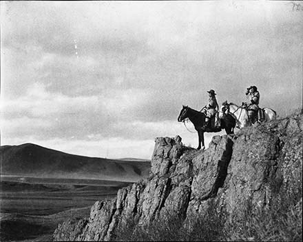
Adam Poucette? (left) [1900]
https://archives.whyte.org/en/permalink/descriptions56947
- Part Of
- Tom Wilson family fonds
- Scope & Content
- Item consists of two indiviudals on horseback, possibly Adam Poucette on the left, overlooking scenery from a rocky edge.
- Date Range
- 1900
- Reference Code
- V701 / LC - 272
- Description Level
- 6 / Item
- GMD
- Photograph
- Negative
1 image
- Part Of
- Tom Wilson family fonds
- Description Level
- 6 / Item
- Fonds Number
- M10
- V701
- Sous-Fonds
- V701
- Reference Code
- V701 / LC - 272
- GMD
- Photograph
- Negative
- Date Range
- 1900
- Physical Description
- 1 photograph : negative, 13 x 18 cm or smaller
- Scope & Content
- Item consists of two indiviudals on horseback, possibly Adam Poucette on the left, overlooking scenery from a rocky edge.
- Subject Access
- Stoney Nakoda
- Indigenous Peoples
- First Nations
- Horses
- Geographic Access
- Alberta
- Related Material
- Recognizing Relations number: RR 544
- Creator
- Wilson, Tom
- Title Source
- Information provided by Stoney Nakoda Elders during the Recognizing Relations project, an archives initiative undertaken in 2014 to identify Indigenous people in photographs held in the Whyte Museum Archives and Special Collections. Identification made by Big Horn Elders: Charlie Abraham and John Wesley
- Processing Status
- Processed
Images
This material is presented as originally created; it may contain outdated cultural descriptions and
potentially offensive content.
Read more.
[Canada] National Transcontinental Railway route
https://archives.whyte.org/en/permalink/catalogue24553
- Medium
- Library - Maps and blueprints (unannotated; published)
- Map
- Published Date
- 1901
- Publisher
- Dept. of the Interior
- Call Number
- C11-3.3
- Publisher
- Dept. of the Interior
- Published Date
- 1901
- Scale
- Scale: 100 miles to 1 inch
- Subjects
- Canada
- Railway routes
- Accession Number
- 400
- Call Number
- C11-3.3
- Collection
- Archives Library
This material is presented as originally created; it may contain outdated cultural descriptions and
potentially offensive content.
Read more.
Geological map of the Dominion of Canada (western sheet)
https://archives.whyte.org/en/permalink/catalogue24772
- Medium
- Library - Book (including soft-cover and pamphlets)
- Map
- Published Date
- 1901
- Publisher
- [Ottawa : Geolocial Survey of Canada?]
- Edition
- 1901 ed.
- Call Number
- C7-5.8
- Edition
- 1901 ed.
- Publisher
- [Ottawa : Geolocial Survey of Canada?]
- Published Date
- 1901
- Physical Description
- 1 map : col
- Scale
- 1 inch = 50 miles
- Subjects
- Geology - The West, Canadian
- Accession Number
- 576
- Call Number
- C7-5.8
- Collection
- Archives Library
This material is presented as originally created; it may contain outdated cultural descriptions and
potentially offensive content.
Read more.
Geological survey of Canada
https://archives.whyte.org/en/permalink/catalogue24784
- Medium
- Library - Book (including soft-cover and pamphlets)
- Map
- Published Date
- 1901
- Publisher
- Dept. of Crown Lands of Ontario
- Call Number
- C7-6.11
- Publisher
- Dept. of Crown Lands of Ontario
- Published Date
- 1901
- Physical Description
- Colour
- Scale
- 1 mile to 1 inch
- Subjects
- Ottawa and Vicinity
- Accession Number
- 400
- Call Number
- C7-6.11
- Collection
- Archives Library
This material is presented as originally created; it may contain outdated cultural descriptions and
potentially offensive content.
Read more.
[Yoho Park Reserve]
https://archives.whyte.org/en/permalink/catalogue23197
- Medium
- Library - Maps and blueprints (unannotated; published)
- Map
- Published Date
- 1901
- Publisher
- Dept. of the Interior, Ottawa
- Call Number
- C2-4.1
- Publisher
- Dept. of the Interior, Ottawa
- Published Date
- 1901
- Physical Description
- 1 map : black and white
- Scale
- Scale: 2 miles to 1 inch
- Bench marks
- Subjects
- Yoho Park Reserve
- Accession Number
- 400
- Call Number
- C2-4.1
- Collection
- Archives Library
This material is presented as originally created; it may contain outdated cultural descriptions and
potentially offensive content.
Read more.
Map showing exploration between Lakes Winnipeg, Manitoba and Winnipegosis
https://archives.whyte.org/en/permalink/catalogue24597
- Medium
- Library - Maps and blueprints (unannotated; published)
- Map
- Published Date
- February 1901
- Publisher
- Department of the Interior
- Call Number
- C11-6.20
- Publisher
- Department of the Interior
- Published Date
- February 1901
- Scale
- 6 miles - 1 inch
- Subjects
- Canada - Prairie Region
- Manitoba
- Notes
- To accompany the report of Thos. Turnbull D.L.S.
- Accession Number
- 400
- Call Number
- C11-6.20
- Collection
- Archives Library
This material is presented as originally created; it may contain outdated cultural descriptions and
potentially offensive content.
Read more.