Narrow Results By
- Byron Harmon fonds 3401
- George Noble fonds 2627
- Peter and Catharine Whyte fonds 2055
- Luxton family fonds 275
- Vaux family fonds 178
- Malcolm Geddes fonds 134
- Bert Riggall fonds 122
- Nicholas Morant fonds 91
- Dan and Mary McCowan fonds 78
- Elliott Barnes fonds 73
- Lloyd Harmon fonds 65
- Moore family fonds 40
Map of North America engraved to illustrate Mitchell's school and family geography
https://archives.whyte.org/en/permalink/catalogue24834
- Medium
- Library - Maps and blueprints (unannotated; published)
- Map
- Published Date
- 1852
- Publisher
- Pennsylvania : S. Augustus Mitchell
- Call Number
- C13.4.6
- Publisher
- Pennsylvania : S. Augustus Mitchell
- Published Date
- 1852
- Physical Description
- 1 map : col
- Scale
- 1 inch = ca 600 miles
- Subjects
- North America
- Hooker, Mount
- Brown, Mount
- Notes
- Map shows Mts. Hooker and Brown, and gives altitudes of same
- Accession Number
- 3612
- Call Number
- C13.4.6
- Collection
- Archives Library
This material is presented as originally created; it may contain outdated cultural descriptions and
potentially offensive content.
Read more.
Stations of the Church Missionary Society
https://archives.whyte.org/en/permalink/catalogue21486
- Medium
- Library - Maps and blueprints (unannotated; published)
- Map
- Published Date
- 1852
- Call Number
- C12-1.10
- Published Date
- 1852
- Subjects
- Hudson's Bay Company's Territories
- Notes
- Route of the Bishop of Montreal from Quebec to Red River in 1844
- Photostatic copy from Public Archives
- Accession Number
- 675
- Call Number
- C12-1.10
- Collection
- Archives Library
This material is presented as originally created; it may contain outdated cultural descriptions and
potentially offensive content.
Read more.
Danubian Principalities
https://archives.whyte.org/en/permalink/catalogue21541
- Medium
- Library - Maps and blueprints (unannotated; published)
- Map
- Published Date
- 1854
- Publisher
- W and A.K. Johnston, Edinburgh
- Call Number
- C13-12.17
- Publisher
- W and A.K. Johnston, Edinburgh
- Published Date
- 1854
- Subjects
- Europe - Central & Eastern
- Accession Number
- 400
- Call Number
- C13-12.17
- Collection
- Archives Library
This material is presented as originally created; it may contain outdated cultural descriptions and
potentially offensive content.
Read more.
Map of Pelly, Ross and Gravel Rivers
https://archives.whyte.org/en/permalink/catalogue24369
- Medium
- Library - Maps and blueprints (unannotated; published)
- Map
- Published Date
- 1910
- Publisher
- Dept. of Mines and Geological Survey
- Call Number
- C8-1.3
- Publisher
- Dept. of Mines and Geological Survey
- Published Date
- 1910
- Scale
- 8 miles to 1 inch
- Subjects
- Yukon and North West Territories
- Notes
- Sources of info: G.M. Dawson, R.G. McConn., J. Keele, W. Ogilvie
- Accession Number
- 576
- Call Number
- C8-1.3
- Collection
- Archives Library
This material is presented as originally created; it may contain outdated cultural descriptions and
potentially offensive content.
Read more.
[Alberta] South-central portion
https://archives.whyte.org/en/permalink/catalogue24416
- Medium
- Library - Maps and blueprints (unannotated; published)
- Map
- Published Date
- 1910
- Publisher
- Dept. of the Interior, Ottawa
- Call Number
- C9-3.1
- Publisher
- Dept. of the Interior, Ottawa
- Published Date
- 1910
- Scale
- Bench marks
- Subjects
- Alberta
- Notes
- 1 duplicate in map room - Accn. 400
- Accession Number
- 400
- Call Number
- C9-3.1
- Collection
- Archives Library
This material is presented as originally created; it may contain outdated cultural descriptions and
potentially offensive content.
Read more.
Sectional map
https://archives.whyte.org/en/permalink/catalogue24464
- Medium
- Library - Maps and blueprints (unannotated; published)
- Map
- Published Date
- 1910
- Publisher
- Dept. of the Interior, Ottawa
- Call Number
- C9-6.4
- Publisher
- Dept. of the Interior, Ottawa
- Published Date
- 1910
- Scale
- 6 miles: 1 inch
- Subjects
- Calgary Sheet
- Accession Number
- 400
- Call Number
- C9-6.4
- Collection
- Archives Library
This material is presented as originally created; it may contain outdated cultural descriptions and
potentially offensive content.
Read more.
Sectional map
https://archives.whyte.org/en/permalink/catalogue24465
- Medium
- Library - Maps and blueprints (unannotated; published)
- Map
- Published Date
- 1910
- Publisher
- Department of the Interior, Ottawa
- Call Number
- C9-6.6
- Publisher
- Department of the Interior, Ottawa
- Published Date
- 1910
- Scale
- 6 miles: 1 inch
- Subjects
- Rocky Mountain House Sheet
- Accession Number
- 400
- Call Number
- C9-6.6
- Collection
- Archives Library
This material is presented as originally created; it may contain outdated cultural descriptions and
potentially offensive content.
Read more.
Map of the Columbia Valley Irrigated Fruitlands of the Windermere district
https://archives.whyte.org/en/permalink/catalogue24532
- Medium
- Library - Maps and blueprints (unannotated; published)
- Map
- Published Date
- 1910
- Call Number
- C10-6.1
- Published Date
- 1910
- Scale
- Scale: 1/2 mile - 1 inch
- Subjects
- Central British Columbia
- Notes
- Photostatic copy from Public Archives
- Accession Number
- 675
- Call Number
- C10-6.1
- Collection
- Archives Library
This material is presented as originally created; it may contain outdated cultural descriptions and
potentially offensive content.
Read more.
- Medium
- Library - Maps and blueprints (unannotated; published)
- Map
- Published Date
- 1910
- Publisher
- Departmentof Interior
- Call Number
- C11-3.8
- Publisher
- Departmentof Interior
- Published Date
- 1910
- Scale
- 100 miles to 1 inch
- Subjects
- Canada
- Railway routes
- Accession Number
- 573
- Call Number
- C11-3.8
- Collection
- Archives Library
This material is presented as originally created; it may contain outdated cultural descriptions and
potentially offensive content.
Read more.
[Rocky Mountains and Yoho Park]
https://archives.whyte.org/en/permalink/catalogue24800
- Medium
- Library - Maps and blueprints (unannotated; published)
- Map
- Published Date
- 1910
- Publisher
- Ottawa : Dept. of the Interior
- Call Number
- C12-1.31
- Publisher
- Ottawa : Dept. of the Interior
- Published Date
- 1910
- Physical Description
- 1 map -- (NMC0014969)
- Scale
- indeterminable
- Notes
- Title information taken from notes pencilled on reverse
- National Map Collection photostat, July 4, 1980
- Call Number
- C12-1.31
- Collection
- Archives Library
This material is presented as originally created; it may contain outdated cultural descriptions and
potentially offensive content.
Read more.
Sectional map [Morley sheet]
https://archives.whyte.org/en/permalink/catalogue15489
- Medium
- Library - Maps and blueprints (unannotated; published)
- Map
- Published Date
- 1910
- Publisher
- Dept. of the Interior, Ottawa
- Call Number
- c9-6.5
- Publisher
- Dept. of the Interior, Ottawa
- Published Date
- 1910
- Scale
- 6 miles to 1 inch
- Accession Number
- 400
- Call Number
- c9-6.5
- Collection
- Archives Library
This material is presented as originally created; it may contain outdated cultural descriptions and
potentially offensive content.
Read more.
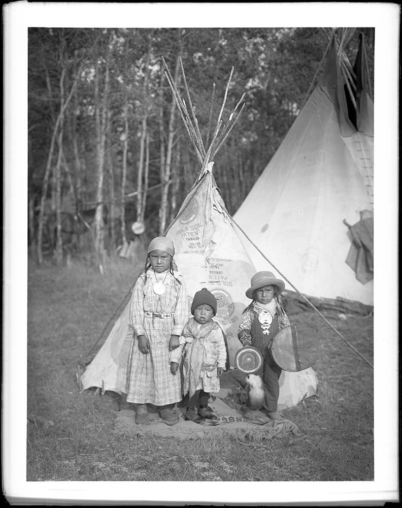
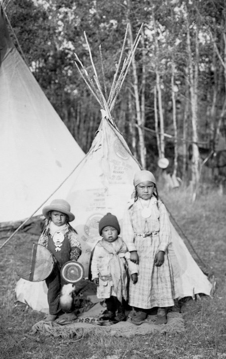
[Unknown children in front of tipi]
https://archives.whyte.org/en/permalink/descriptions49088
- Part Of
- Luxton family fonds
- Scope & Content
- [Unknown children in front of tipi]
- Date Range
- 1910
- Reference Code
- LUX / I / D3a / 7 / NG - 7
- Description Level
- 6 / Item
- GMD
- Photograph
- Negative
2 images
- Part Of
- Luxton family fonds
- Description Level
- 6 / Item
- Fonds Number
- LUX
- Series
- LUX / I / D : Personal and professional
- Sous-Fonds
- LUX / I : Norman Luxton sous-fonds
- Sub-Series
- LUX / I / D / 3: Organizations
- Accession Number
- n/a
- Reference Code
- LUX / I / D3a / 7 / NG - 7
- GMD
- Photograph
- Negative
- Date Range
- 1910
- Physical Description
- 1 photograph : b&w glass negative ; 20.3 x 25.4 cm
- Scope & Content
- [Unknown children in front of tipi]
- Subject Access
- First Nations
- Indigenous Peoples
- Geographic Access
- Alberta
- Banff
- Banff National Park
- Language
- English
- Conservation
- Scratches on negative
- Title Source
- Stoney Nakoda Elders provided naming and other culturally relevant information during interviews held for Recognizing Relations, an archives initiative active from 2014-2023. . No identification was possible.
- The goal of this initiative was to name local Indigenous peoples in photographs held in the WMCR archives as well as encouraging access for Indigenous communities to these images.
- Processing Status
- Processed
Images
This material is presented as originally created; it may contain outdated cultural descriptions and
potentially offensive content.
Read more.
Jack W. Brewster in San Francisco
https://archives.whyte.org/en/permalink/descriptions57448
- Part Of
- Jim Brewster family fonds
- Scope & Content
- File consists of one tintype photograph of Jack W. Brewster posing against a fence in San Francisco, 1910, with a beach visible in the backgroung.
- Date Range
- 1910
- Reference Code
- V90 / VI / PT - 1
- Description Level
- 5 / File
- GMD
- Photograph
- Tintype
- Part Of
- Jim Brewster family fonds
- Description Level
- 5 / File
- Fonds Number
- M436
- V90
- Series
- V90 / VI : Later acquisitions
- Sous-Fonds
- V90
- Accession Number
- 2023.09
- Reference Code
- V90 / VI / PT - 1
- GMD
- Photograph
- Tintype
- Date Range
- 1910
- Physical Description
- 1 photograph : tintype ; 6 x 9 cm
- Scope & Content
- File consists of one tintype photograph of Jack W. Brewster posing against a fence in San Francisco, 1910, with a beach visible in the backgroung.
- Name Access
- Brewster, Jack Walker
- Subject Access
- Travel
- Family and personal life
- Recreation
- Swimming
- Beach
- Tourism
- Geographic Access
- United States of America
- California
- San Francisco
- Access Restrictions
- Fragile - handle with caution
- Language
- English
- Title Source
- Title based on contents of file
- Processing Status
- Processed
This material is presented as originally created; it may contain outdated cultural descriptions and
potentially offensive content.
Read more.
Princess May Shipwreck Framed Print
https://archives.whyte.org/en/permalink/descriptions54228
- Part Of
- Nicholas Morant fonds
- Scope & Content
- 1 framed print, signed and annotated by W.H. Case (presumably the creator of the photograph), depicting shipwrecked S.S. Princess May, 1910 (Canadian Pacific envelope attached to the back, contains 2 news clippings about the Princess May ship and one page detailing the cargo weights, measurements, …
- Date Range
- 1910
- Reference Code
- V500 / III / D / 4 / PC - 8 O.S.
- Description Level
- 6 / Item
- GMD
- Photograph
- Photograph print
- Textual record
- Part Of
- Nicholas Morant fonds
- Description Level
- 6 / Item
- Fonds Number
- M300 / V500 / S20
- Sous-Fonds
- V500
- Sub-Series
- V500 / III / D / 4 : Personal and Family Photography
- Accession Number
- 7784
- Reference Code
- V500 / III / D / 4 / PC - 8 O.S.
- Responsibility
- Nicholas Morant
- Date Range
- 1910
- Physical Description
- 1 Framed Photograph: print; b&w
- Scope & Content
- 1 framed print, signed and annotated by W.H. Case (presumably the creator of the photograph), depicting shipwrecked S.S. Princess May, 1910 (Canadian Pacific envelope attached to the back, contains 2 news clippings about the Princess May ship and one page detailing the cargo weights, measurements, etc. of the same ship).
- Notes
- Print annotated with the following: "C.P.R. CO. S.S. PRINCESS MAY, WRECKED, ON SENTINEL IS. ALASKA. AUG. 5. 1910." "W.H. CASE 433"
- Name Access
- Case, W.H.
- Geographic Access
- United States of America
- Alaska
- Access Restrictions
- This item is not to be accessed or distributed without the explicit permission of its identified owner(s).
- Reproduction Restrictions
- This item is not to be reproduced without the explicit permission of its identified owner(s).
- Language
- English
- Creator
- W.H. Case
- Title Source
- Title based on contents of file
- Processing Status
- Processed
This material is presented as originally created; it may contain outdated cultural descriptions and
potentially offensive content.
Read more.
(Miette R-Grand Trunk Pacific Rwy Line)
https://archives.whyte.org/en/permalink/catalogue24500
- Medium
- Library - Maps and blueprints (unannotated; published)
- Map
- Published Date
- August 4, 1910
- Publisher
- Department of the Interior
- Call Number
- C9-7.45
- Publisher
- Department of the Interior
- Published Date
- August 4, 1910
- Physical Description
- 1 map : black and white
- Scale
- 40 chains: 1 inch
- Accession Number
- SG7500
- Call Number
- C9-7.45
- Collection
- Archives Library
This material is presented as originally created; it may contain outdated cultural descriptions and
potentially offensive content.
Read more.
- Medium
- Library - Maps and blueprints (unannotated; published)
- Map
- Published Date
- 1911
- Publisher
- Dept. of the Interior
- Call Number
- C11-2.2
- Publisher
- Dept. of the Interior
- Published Date
- 1911
- Scale
- Scale: 100 miles to 1 inch
- Subjects
- Canada
- Accession Number
- 400
- Call Number
- C11-2.2
- Collection
- Archives Library
This material is presented as originally created; it may contain outdated cultural descriptions and
potentially offensive content.
Read more.
Canadian Pacific Railway
https://archives.whyte.org/en/permalink/catalogue24554
- Medium
- Library - Maps and blueprints (unannotated; published)
- Map
- Published Date
- 1911 (corrected to June, 1912)
- Publisher
- Canadian Pacific Railway
- Call Number
- C11-3.5
- Publisher
- Canadian Pacific Railway
- Published Date
- 1911 (corrected to June, 1912)
- Scale
- Scale: 1" -- 75 miles
- Subjects
- Canada
- Railway routes
- Notes
- The Minneapolis, St. Paul and Sault. Ste. Marie Railway, The Duluth, South Shore and Atlantic Railway and Connections
- Accession Number
- 7000
- Call Number
- C11-3.5
- Collection
- Archives Library
This material is presented as originally created; it may contain outdated cultural descriptions and
potentially offensive content.
Read more.
Mountains of the Continental Divide north of the Yellowhead Pass and Yellowhead Pass Route
https://archives.whyte.org/en/permalink/catalogue24624
- Medium
- Library - Maps and blueprints (unannotated; published)
- Map
- Published Date
- 1911
- Publisher
- Surveyor General's Office
- Call Number
- C3-4.3
- Publisher
- Surveyor General's Office
- Published Date
- 1911
- Physical Description
- Colour
- Scale
- Scale: 1": 2 miles
- Relief: Spot heights
- Subjects
- Mount Robson
- Notes
- 3 Duplicates in map room
- Accession Number
- 400
- 1105
- 2781
- Call Number
- C3-4.3
- Collection
- Archives Library
This material is presented as originally created; it may contain outdated cultural descriptions and
potentially offensive content.
Read more.
Sectional map
https://archives.whyte.org/en/permalink/catalogue24628
- Medium
- Library - Maps and blueprints (unannotated; published)
- Map
- Published Date
- 1911
- Call Number
- C3-5.1
- Published Date
- 1911
- Physical Description
- Black and white
- Scale
- Scale: 3 miles to 1 inch
- Relief: Spot heights
- Subjects
- Donald Sheet
- Notes
- Map of parks - Glacier, Yoho, Rocky Mountains
- Accession Number
- 400
- Call Number
- C3-5.1
- Collection
- Archives Library
This material is presented as originally created; it may contain outdated cultural descriptions and
potentially offensive content.
Read more.
Geological survey
https://archives.whyte.org/en/permalink/catalogue24777
- Medium
- Library - Book (including soft-cover and pamphlets)
- Map
- Published Date
- 1911
- Publisher
- Dept. of Mines
- Call Number
- C7-6.3
- Publisher
- Dept. of Mines
- Published Date
- 1911
- Physical Description
- Colour
- Scale
- Scale: 1 mile to 1 inch
- Relief: Bench marks
- Subjects
- Nova Scotia
- Accession Number
- 400
- Call Number
- C7-6.3
- Collection
- Archives Library
This material is presented as originally created; it may contain outdated cultural descriptions and
potentially offensive content.
Read more.