Narrow Results By
- Luxton family fonds 35
- Dorothy Wardle fonds 26
- Peter and Catharine Whyte fonds 21
- Nicholas Morant fonds 19
- Murray Hay fonds 18
- Kidney family fonds 14
- Ben Gadd fonds 8
- Trail Riders of the Canadian Rockies fonds 6
- Douglas Leighton fonds 5
- Aileen Harmon fonds 4
- Jean A. Hembroff MacDonald fonds 4
- George K. K. (Tommy) Link fonds 3
Stations of the Church Missionary Society
https://archives.whyte.org/en/permalink/catalogue21486
- Medium
- Library - Maps and blueprints (unannotated; published)
- Map
- Published Date
- 1852
- Call Number
- C12-1.10
- Published Date
- 1852
- Subjects
- Hudson's Bay Company's Territories
- Notes
- Route of the Bishop of Montreal from Quebec to Red River in 1844
- Photostatic copy from Public Archives
- Accession Number
- 675
- Call Number
- C12-1.10
- Collection
- Archives Library
This material is presented as originally created; it may contain outdated cultural descriptions and
potentially offensive content.
Read more.
Map of North America engraved to illustrate Mitchell's school and family geography
https://archives.whyte.org/en/permalink/catalogue24834
- Medium
- Library - Maps and blueprints (unannotated; published)
- Map
- Published Date
- 1852
- Publisher
- Pennsylvania : S. Augustus Mitchell
- Call Number
- C13.4.6
- Publisher
- Pennsylvania : S. Augustus Mitchell
- Published Date
- 1852
- Physical Description
- 1 map : col
- Scale
- 1 inch = ca 600 miles
- Subjects
- North America
- Hooker, Mount
- Brown, Mount
- Notes
- Map shows Mts. Hooker and Brown, and gives altitudes of same
- Accession Number
- 3612
- Call Number
- C13.4.6
- Collection
- Archives Library
This material is presented as originally created; it may contain outdated cultural descriptions and
potentially offensive content.
Read more.
Danubian Principalities
https://archives.whyte.org/en/permalink/catalogue21541
- Medium
- Library - Maps and blueprints (unannotated; published)
- Map
- Published Date
- 1854
- Publisher
- W and A.K. Johnston, Edinburgh
- Call Number
- C13-12.17
- Publisher
- W and A.K. Johnston, Edinburgh
- Published Date
- 1854
- Subjects
- Europe - Central & Eastern
- Accession Number
- 400
- Call Number
- C13-12.17
- Collection
- Archives Library
This material is presented as originally created; it may contain outdated cultural descriptions and
potentially offensive content.
Read more.
Plan of lots 1A, 2A & 4A south of Bow River, Banff, Alberta
https://archives.whyte.org/en/permalink/catalogue23265
- Medium
- Library - Maps and blueprints (unannotated; published)
- Map
- Published Date
- 1950
- Publisher
- Banff: Resident Engineer's Office
- Call Number
- C4-1.10a
- Publisher
- Banff: Resident Engineer's Office
- Published Date
- 1950
- Physical Description
- 1 map : blueprint
- Scale
- Scale: 1 inch = 40 feet
- Subjects
- Banff townsite
- Notes
- Signed: J.R.W.
- Bearings shown refer to plan approved . . . 10th May, 1913
- Accession Number
- 3500
- Call Number
- C4-1.10a
- Collection
- Archives Library
This material is presented as originally created; it may contain outdated cultural descriptions and
potentially offensive content.
Read more.
[Mistaya 82N/NE, Alta.-B.C.]
https://archives.whyte.org/en/permalink/catalogue23988
- Medium
- Library - Maps and blueprints (unannotated; published)
- Map
- Published Date
- 1950
- Publisher
- Dept. of Mines and Technical Surveys
- Call Number
- NTS
- 82N/NE
- Publisher
- Dept. of Mines and Technical Surveys
- Published Date
- 1950
- Physical Description
- 1 map : col
- Scale
- Scale: 1:126,720
- Relief: Contour Interval 200 ft.
- Subjects
- Mistaya
- British Columbia
- Notes
- National Topographic System
- Accession Number
- 3000
- Call Number
- NTS
- 82N/NE
- Collection
- Archives Library
This material is presented as originally created; it may contain outdated cultural descriptions and
potentially offensive content.
Read more.
[McDame 104 P - B.C.]
https://archives.whyte.org/en/permalink/catalogue24090
- Medium
- Library - Maps and blueprints (unannotated; published)
- Map
- Published Date
- 1950
- Publisher
- Dept. of Mines and Technical Surveys
- Call Number
- NTS
- 104P
- Publisher
- Dept. of Mines and Technical Surveys
- Published Date
- 1950
- Physical Description
- 1 map : col
- Scale
- Scale: 1:250,000
- Relief: Contour interval 500 ft.
- Subjects
- McDame
- British Columbia
- Accession Number
- 3000
- Call Number
- NTS
- 104P
- Collection
- Archives Library
This material is presented as originally created; it may contain outdated cultural descriptions and
potentially offensive content.
Read more.
Letters to Mother [January - June 1950]
https://archives.whyte.org/en/permalink/descriptions7472
- Part Of
- Peter and Catharine Whyte fonds
- Scope & Content
- File pertains to 51 letters written by Catharine Robb Whyte to her mother, Edith Morse Robb from January 2 to June 30, 1950. Topics include day to day life, Banff events, visits from friends, photography, painting, weather [including temperatures down to -50F (-45C) in January], the CPR test of the…
- Date Range
- 1950
- Reference Code
- M36 / I / A / 2b / i / 126
- Description Level
- 5 / File
- GMD
- Postcard
- Private record
1 image
1 Electronic Resource
- Part Of
- Peter and Catharine Whyte fonds
- Description Level
- 5 / File
- Fonds Number
- M36 / V683 / S37
- Series
- I.A.2. Catharine Robb Whyte papers / photographs
- Sous-Fonds
- M36
- Accession Number
- .
- Reference Code
- M36 / I / A / 2b / i / 126
- Date Range
- 1950
- Physical Description
- 1.6 cm of textual records (93 pages ; 21.4 x 27.5 cm or smaller)
- History / Biographical
- See fonds level description.
- Scope & Content
- File pertains to 51 letters written by Catharine Robb Whyte to her mother, Edith Morse Robb from January 2 to June 30, 1950. Topics include day to day life, Banff events, visits from friends, photography, painting, weather [including temperatures down to -50F (-45C) in January], the CPR test of their new diesel engines, events and people in Concord, world news, radio programs, the North American Ski Championship in February [for which Pete designed pins], the Banff Winter Carnival, installing fluorescent lights in the kitchen [prior to that they had "temporary" lights], purchasing a new Jeep stationwagon, the Duke and Duchess of Windsor visiting Banff in April, driving to Concord in May and back to Banff in June, plans for Banff Indian Days, a trip to Bow Lake, and Pete and Catharine's 20th wedding anniversary. Also includes postcards.
- Notes
- Please note: language pertaining to Indigenous Peoples used throughout is outdated and may be offensive. Letters are typed and hand-written. Many typed letters have hand-written notes and post scripts added throughout. Some letters are marked with a small x in pencil, indicating where Jon Whyte made notes for use in his project "Catharine Robb Whyte, Peter Whyte: Commemorative Portfolio," originally published in 1981.
- Name Access
- Whyte, Catharine
- Whyte, Peter
- Robb, Edith Morse
- Moore, Pearl
- Moore, Edmee
- Moore, Phil
- Campbell, Gray
- Campbell, Eleanor
- Simpson, Jimmy, Sr.
- Simpson, Billie
- Simpson, Jimmy, Jr.
- White, Annie
- Morant, Nicholas (Nick)
- Morant, Willie
- Whyte, Jon
- Watson, Sir Norman
- Encil, George
- Beil, Charlie
- Luxton, Norman
- Subject Access
- Activities
- Animals
- Art
- Artists
- Banff
- Banff Winter Carnival
- Birds
- Bird watching
- Birthday
- Businesses
- Camping
- Canadian Pacific Railway
- Children
- Community events
- Community life
- Correspondence
- Deer
- Family
- Family and personal life
- First Nations
- Funeral
- Home
- Hospital
- Indigenous Peoples
- Lake Louise
- Leisure
- Mountain
- Norquay Ski Hill
- Num-Ti-Jah Lodge
- Painting
- Personal and Family Life
- Photography
- Post Office
- Ranching
- Royal tours
- Royalty
- Scenery
- Ski areas
- Ski jumping
- Ski racing
- Skiers
- Skiing
- Stoney Nakoda
- Sunshine Ski Area
- Sunshine Village
- Trains
- Transportation
- Travel
- Upper Hot Springs Hotel
- Weather
- Wildlife
- Winter
- Winter sports
- Geographic Access
- Banff
- Lake Louise
- Bow Lake
- Banff National Park
- Morley
- Calgary
- Alberta
- Montana
- North Dakota
- Ohio
- Minnesota
- Concord
- Massachusetts
- Canada
- United States of America
- Language
- English
- Creator
- Robb Whyte, Catharine
- Title Source
- Title based on contents of file
- Processing Status
- Processed
Electronic Resources
Images

This material is presented as originally created; it may contain outdated cultural descriptions and
potentially offensive content.
Read more.
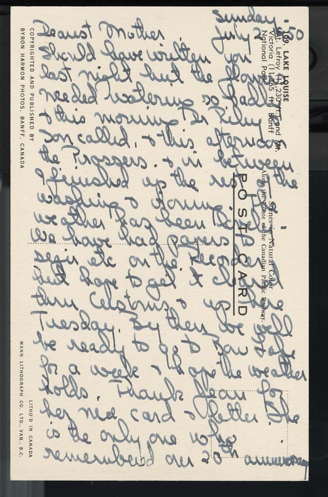
Letters to Mother [July - November 1950]
https://archives.whyte.org/en/permalink/descriptions7473
- Part Of
- Peter and Catharine Whyte fonds
- Scope & Content
- File pertains to 43 letters written by Catharine Robb Whyte to her mother, Edith Morse Robb from July 2 to November 14, 1950. Topics include trips to Bow Lake [mostly to sketch/paint] during the summer, day to day life, Banff events, visits from friends, the Calgary Stampede, photography, painting,…
- Date Range
- 1950
- Reference Code
- M36 / I / A / 2b / i / 127
- Description Level
- 5 / File
- GMD
- Postcard
- Private record
1 image
1 Electronic Resource
- Part Of
- Peter and Catharine Whyte fonds
- Description Level
- 5 / File
- Fonds Number
- M36 / V683 / S37
- Series
- I.A.2. Catharine Robb Whyte papers / photographs
- Sous-Fonds
- M36
- Accession Number
- .
- Reference Code
- M36 / I / A / 2b / i / 127
- Date Range
- 1950
- Physical Description
- 1.3 cm of textual records (69 pages ; 21.4 x 27.5 cm or smaller)
- History / Biographical
- See fond level description.
- Scope & Content
- File pertains to 43 letters written by Catharine Robb Whyte to her mother, Edith Morse Robb from July 2 to November 14, 1950. Topics include trips to Bow Lake [mostly to sketch/paint] during the summer, day to day life, Banff events, visits from friends, the Calgary Stampede, photography, painting, weather, Banff Indian Days, events and people in Concord, radio programs, getting a new recorder [possibly a reel-to-reel], a train strike in August, a trip to visit the Capmbells in Cowley, funerals, day trips to Lake Louise and Moraine Lake, meeting composer Alec Templeton and playing recorded First Nations songs for him, getting the annual Christmas card together, and planning a trip to Hawaii for the winter. Also includes postcards.
- Notes
- Please note: language pertaining to Indigenous Peoples used throughout is outdated and may be offensive. Letters are mostly typed, some hand-written. Many typed letters have hand-written notes and post scripts added throughout. Some letters are marked with a small x in pencil, indicating where Jon Whyte made notes for use in his project "Catharine Robb Whyte, Peter Whyte: Commemorative Portfolio," originally published in 1981. 127 - 22 insert 01 was sealed prior to accession - the envelope is empty.
- Name Access
- Whyte, Catharine
- Whyte, Peter
- Robb, Edith Morse
- Moore, Pearl
- Moore, Edmee
- Moore, Phil
- Campbell, Gray
- Campbell, Eleanor
- Simpson, Jimmy, Sr.
- Simpson, Billie
- Simpson, Jimmy, Jr.
- White, Annie
- Morant, Nicholas (Nick)
- Morant, Willie
- Whyte, Jon
- Castle, Donald
- Hinman, Caroline
- Perren, Walter
- Rummel, Elizabeth
- White, Bubby
- Link, George K. K. (Tommy)
- Greenham, Margaret
- Greenham, Henry
- Subject Access
- Activities
- Animals
- Art
- Artists
- Banff
- Banff Indian Days
- Birds
- Bird watching
- Birthday
- Businesses
- Camping
- Canadian Pacific Railway
- Children
- Christmas
- Community events
- Community life
- Correspondence
- Curling
- Family
- Family and personal life
- First Nations
- Funeral
- Home
- Hospital
- Indigenous Peoples
- Lake Louise
- Leisure
- Mountain
- Num-Ti-Jah Lodge
- Painting
- Personal and Family Life
- Photography
- Post Office
- Ranching
- Scenery
- Stoney Nakoda
- Trains
- Trans-Canada Highway
- Travel
- Winter
- Weather
- Geographic Access
- Banff
- Lake Louise
- Bow Lake
- Banff National Park
- Morley
- Cowley
- Calgary
- Alberta
- Concord
- Massachusetts
- Canada
- United States of America
- Language
- English
- Creator
- Robb Whyte, Catharine
- Title Source
- Title based on contents of file
- Processing Status
- Processed
Electronic Resources
Images
This material is presented as originally created; it may contain outdated cultural descriptions and
potentially offensive content.
Read more.
Northwestern United States and Neighbouring Canadian Provinces
https://archives.whyte.org/en/permalink/catalogue24810
- Medium
- Library - Maps and blueprints (unannotated; published)
- Map
- Published Date
- 1950
- Publisher
- National Geographic Society
- Call Number
- C13-1.1(b)
- Publisher
- National Geographic Society
- Published Date
- 1950
- Scale
- Scale: 39.46 miles to 1 inch
- Relief: Bench marks
- Subjects
- Northwestern United States
- Accession Number
- 495
- Call Number
- C13-1.1(b)
- Collection
- Archives Library
This material is presented as originally created; it may contain outdated cultural descriptions and
potentially offensive content.
Read more.
- Date
- 1950 – 1950
- Material
- wood; metal; plastic, polystyrene
- Catalogue Number
- 102.04.0163
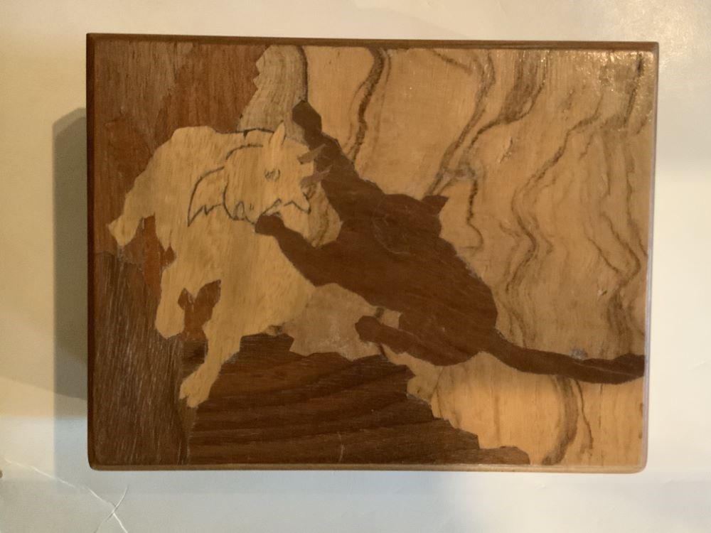
- Description
- A handmade (mortise and tenon construction) wooden box with feet and a hinged lid. The top has an inlaid wood design of a cougar attacking a mountain goat.
1 image
- Title
- Trinket Box
- Date
- 1950 – 1950
- Material
- wood; metal; plastic, polystyrene
- Dimensions
- 5.7 x 10.5 x 13.7 cm
- Description
- A handmade (mortise and tenon construction) wooden box with feet and a hinged lid. The top has an inlaid wood design of a cougar attacking a mountain goat.
- Credit
- Gift of Pearl Evelyn Moore, Banff, 1979
- Catalogue Number
- 102.04.0163
Images
This material is presented as originally created; it may contain outdated cultural descriptions and
potentially offensive content.
Read more.
The Selkirk Range Text and Maps
https://archives.whyte.org/en/permalink/descriptions54163
- Part Of
- Nicholas Morant fonds
- Scope & Content
- File consists of 2 volumes, 1 textual and 1 cartographic, from 'The Selkirk Range British Columbia'. Volume 1 pertains to a textual account of the Selkirk region; volume 2 pertains to a collection of various topographical maps of the Selkirk region. Volume 1 is signed by Emmeline Wheeler.
- Date Range
- 1951
- Reference Code
- M300 / III / D / 5 / 52 to 53
- Description Level
- 5 / File
- GMD
- Textual record
- Private record
- Map
- Part Of
- Nicholas Morant fonds
- Description Level
- 5 / File
- Fonds Number
- M300 / S20 / V500
- Sous-Fonds
- M300
- Sub-Series
- M300 / III / D / 5 : Personal Interest and Gifts
- Accession Number
- 7784
- Reference Code
- M300 / III / D / 5 / 52 to 53
- Responsibility
- Produced by A.O. Wheeler
- Date Range
- 1951
- Physical Description
- Textual record: book & Cartographic records: maps
- Scope & Content
- File consists of 2 volumes, 1 textual and 1 cartographic, from 'The Selkirk Range British Columbia'. Volume 1 pertains to a textual account of the Selkirk region; volume 2 pertains to a collection of various topographical maps of the Selkirk region. Volume 1 is signed by Emmeline Wheeler.
- Storage Range
- In file box M300 / III / D / 5 / 52 to M300 / III / D / 5 / 53.
- Name Access
- Wheeler, A.O.
- Geographic Access
- Canada
- Canadian Rocky Mountains
- Selkirks
- Access Restrictions
- Items in this file are not to be accessed or distributed without the explicit permission of their identified copyright owners.
- Reproduction Restrictions
- Items in this file are not to be reproduced without the explicit permission of their identified copyright owners.
- Language
- English
- Creator
- A.O. Wheeler
- Title Source
- Title based on contents of file
- Processing Status
- Processed
This material is presented as originally created; it may contain outdated cultural descriptions and
potentially offensive content.
Read more.
[Prince Albert Park]
https://archives.whyte.org/en/permalink/catalogue23233
- Medium
- Library - Maps and blueprints (unannotated; published)
- Map
- Published Date
- 1951
- Publisher
- Dept. of Mines and Technical Surveys
- Call Number
- C2-9.2
- Publisher
- Dept. of Mines and Technical Surveys
- Published Date
- 1951
- Physical Description
- 1 map : col
- Scale
- Scale: 1 inch : 2.37 miles
- Bench marks
- Subjects
- Prince Albert National Park
- Accession Number
- 718
- Call Number
- C2-9.2
- Collection
- Archives Library
This material is presented as originally created; it may contain outdated cultural descriptions and
potentially offensive content.
Read more.
[Dewar Creek 82F/16E, B.C.]
https://archives.whyte.org/en/permalink/catalogue23582
- Medium
- Library - Maps and blueprints (unannotated; published)
- Map
- Published Date
- 1951
- Publisher
- Department of National Defence
- Call Number
- NTS
- 82F/16E
- Publisher
- Department of National Defence
- Published Date
- 1951
- Physical Description
- 1 map : col
- Scale
- Scale: 1:50,000
- Relief: Contour interval 100 ft.
- Subjects
- Dewar Creek
- British Columbia
- Notes
- National Topographic System
- Accession Number
- 5500
- Call Number
- NTS
- 82F/16E
- Collection
- Archives Library
This material is presented as originally created; it may contain outdated cultural descriptions and
potentially offensive content.
Read more.
[Dewar Creek 82F/16W, B.C.]
https://archives.whyte.org/en/permalink/catalogue23583
- Medium
- Library - Maps and blueprints (unannotated; published)
- Map
- Published Date
- 1951
- Publisher
- Department of National Defence
- Call Number
- NTS
- 82F/16W
- Publisher
- Department of National Defence
- Published Date
- 1951
- Physical Description
- 1 map : col
- Scale
- Scale: 1:50,000
- Relief: Contour interval 100 ft.
- Subjects
- Dewar Creek
- British Columbia
- Notes
- National Topographic System
- Accession Number
- 5500
- Call Number
- NTS
- 82F/16W
- Collection
- Archives Library
This material is presented as originally created; it may contain outdated cultural descriptions and
potentially offensive content.
Read more.
National Geographic System
https://archives.whyte.org/en/permalink/catalogue23854
- Medium
- Library - Maps and blueprints (unannotated; published)
- Map
- Published Date
- 1951
- Publisher
- Department of National Defence
- Call Number
- NTS
- 82F/4W
- Publisher
- Department of National Defence
- Published Date
- 1951
- Physical Description
- 1 map : col
- Scale
- Scale: 1:50,000
- Relief: Contour interval 100 ft.
- Subjects
- Rossland-Trail
- British Columbia
- Accession Number
- 5500
- Call Number
- NTS
- 82F/4W
- Collection
- Archives Library
This material is presented as originally created; it may contain outdated cultural descriptions and
potentially offensive content.
Read more.
National Topographic System
https://archives.whyte.org/en/permalink/catalogue23855
- Medium
- Library - Maps and blueprints (unannotated; published)
- Map
- Published Date
- 1951
- Publisher
- Department of National Defence
- Call Number
- NTS
- 82F/4E
- Publisher
- Department of National Defence
- Published Date
- 1951
- Physical Description
- 1 map : col
- Scale
- Scale: 1:50,000
- Relief: Contour interval 100 ft.
- Subjects
- Rossland-Trail
- British Columbia
- Accession Number
- 5500
- Call Number
- NTS
- 82F/4E
- Collection
- Archives Library
This material is presented as originally created; it may contain outdated cultural descriptions and
potentially offensive content.
Read more.
[St. Mary Lake 82F/9 East - B.C.]
https://archives.whyte.org/en/permalink/catalogue23865
- Medium
- Library - Maps and blueprints (unannotated; published)
- Map
- Published Date
- 1951
- Publisher
- Department of National Defence
- Call Number
- NTS
- 82F/9E
- Publisher
- Department of National Defence
- Published Date
- 1951
- Physical Description
- Colour
- Scale
- Scale: 1:50,000
- Relief: Contour interval 100 ft
- Subjects
- St. Mary Lake 82F/9 East - B.C.
- Notes
- National Topographic System
- Accession Number
- 5500
- Call Number
- NTS
- 82F/9E
- Collection
- Archives Library
This material is presented as originally created; it may contain outdated cultural descriptions and
potentially offensive content.
Read more.
[St. Mary Lake 82F/9 West - B.C.]
https://archives.whyte.org/en/permalink/catalogue23866
- Medium
- Library - Maps and blueprints (unannotated; published)
- Map
- Published Date
- 1951
- Publisher
- Department of National Defence
- Call Number
- NTS
- 82F/9W
- Publisher
- Department of National Defence
- Published Date
- 1951
- Physical Description
- Colour
- Scale
- Scale: 1:50,000
- Relief: Contour interval 100 ft.
- Subjects
- St. Mary Lake 82F/9 West - B.C.
- Notes
- National Topographic System
- Accession Number
- 5500
- Call Number
- NTS
- 82F/9W
- Collection
- Archives Library
This material is presented as originally created; it may contain outdated cultural descriptions and
potentially offensive content.
Read more.
[Scuzzy Mountain 92H/13 East - B.C.]
https://archives.whyte.org/en/permalink/catalogue23874
- Medium
- Library - Maps and blueprints (unannotated; published)
- Map
- Published Date
- 1951
- Publisher
- Department of Mines and Technical Surveys
- Call Number
- NTS
- 92H/13E
- Publisher
- Department of Mines and Technical Surveys
- Published Date
- 1951
- Physical Description
- Colour
- Scale
- Scale: 1:50,000
- Relief: Contour interval 100 ft.
- Subjects
- Scuzzy Mountain 92H/13 East - B.C.
- Notes
- National Topographic System
- Accession Number
- 7000
- Call Number
- NTS
- 92H/13E
- Collection
- Archives Library
This material is presented as originally created; it may contain outdated cultural descriptions and
potentially offensive content.
Read more.
[Blueberry River]
https://archives.whyte.org/en/permalink/catalogue23970
- Medium
- Library - Maps and blueprints (unannotated; published)
- Map
- Published Date
- 1951
- Publisher
- Dept. of Mines & Technical Surveys
- Call Number
- NTS
- 94A/NW
- Publisher
- Dept. of Mines & Technical Surveys
- Published Date
- 1951
- Physical Description
- 1 map : col
- Scale
- Scale: 1:126,720
- Subjects
- Blueberry River
- Notes
- National Topographic System
- Accession Number
- 3000
- Call Number
- NTS
- 94A/NW
- Collection
- Archives Library
This material is presented as originally created; it may contain outdated cultural descriptions and
potentially offensive content.
Read more.