Narrow Results By
- Luxton family fonds 55
- Dorothy Wardle fonds 14
- Nicholas Morant fonds 14
- Trail Riders of the Canadian Rockies fonds 10
- Kidney family fonds 6
- Ben Gadd fonds 5
- Jean A. Hembroff MacDonald fonds 5
- Aileen Harmon fonds 2
- Bob Smith fonds 2
- George K. K. (Tommy) Link fonds 2
- Girl Guides of Canada, Banff fonds 2
- John Monod fonds 2
Map of North America engraved to illustrate Mitchell's school and family geography
https://archives.whyte.org/en/permalink/catalogue24834
- Medium
- Library - Maps and blueprints (unannotated; published)
- Map
- Published Date
- 1852
- Publisher
- Pennsylvania : S. Augustus Mitchell
- Call Number
- C13.4.6
- Publisher
- Pennsylvania : S. Augustus Mitchell
- Published Date
- 1852
- Physical Description
- 1 map : col
- Scale
- 1 inch = ca 600 miles
- Subjects
- North America
- Hooker, Mount
- Brown, Mount
- Notes
- Map shows Mts. Hooker and Brown, and gives altitudes of same
- Accession Number
- 3612
- Call Number
- C13.4.6
- Collection
- Archives Library
This material is presented as originally created; it may contain outdated cultural descriptions and
potentially offensive content.
Read more.
Stations of the Church Missionary Society
https://archives.whyte.org/en/permalink/catalogue21486
- Medium
- Library - Maps and blueprints (unannotated; published)
- Map
- Published Date
- 1852
- Call Number
- C12-1.10
- Published Date
- 1852
- Subjects
- Hudson's Bay Company's Territories
- Notes
- Route of the Bishop of Montreal from Quebec to Red River in 1844
- Photostatic copy from Public Archives
- Accession Number
- 675
- Call Number
- C12-1.10
- Collection
- Archives Library
This material is presented as originally created; it may contain outdated cultural descriptions and
potentially offensive content.
Read more.
Danubian Principalities
https://archives.whyte.org/en/permalink/catalogue21541
- Medium
- Library - Maps and blueprints (unannotated; published)
- Map
- Published Date
- 1854
- Publisher
- W and A.K. Johnston, Edinburgh
- Call Number
- C13-12.17
- Publisher
- W and A.K. Johnston, Edinburgh
- Published Date
- 1854
- Subjects
- Europe - Central & Eastern
- Accession Number
- 400
- Call Number
- C13-12.17
- Collection
- Archives Library
This material is presented as originally created; it may contain outdated cultural descriptions and
potentially offensive content.
Read more.
[Mistaya 82N/NE, Alta.-B.C.]
https://archives.whyte.org/en/permalink/catalogue23988
- Medium
- Library - Maps and blueprints (unannotated; published)
- Map
- Published Date
- 1950
- Publisher
- Dept. of Mines and Technical Surveys
- Call Number
- NTS
- 82N/NE
- Publisher
- Dept. of Mines and Technical Surveys
- Published Date
- 1950
- Physical Description
- 1 map : col
- Scale
- Scale: 1:126,720
- Relief: Contour Interval 200 ft.
- Subjects
- Mistaya
- British Columbia
- Notes
- National Topographic System
- Accession Number
- 3000
- Call Number
- NTS
- 82N/NE
- Collection
- Archives Library
This material is presented as originally created; it may contain outdated cultural descriptions and
potentially offensive content.
Read more.
[McDame 104 P - B.C.]
https://archives.whyte.org/en/permalink/catalogue24090
- Medium
- Library - Maps and blueprints (unannotated; published)
- Map
- Published Date
- 1950
- Publisher
- Dept. of Mines and Technical Surveys
- Call Number
- NTS
- 104P
- Publisher
- Dept. of Mines and Technical Surveys
- Published Date
- 1950
- Physical Description
- 1 map : col
- Scale
- Scale: 1:250,000
- Relief: Contour interval 500 ft.
- Subjects
- McDame
- British Columbia
- Accession Number
- 3000
- Call Number
- NTS
- 104P
- Collection
- Archives Library
This material is presented as originally created; it may contain outdated cultural descriptions and
potentially offensive content.
Read more.
Northwestern United States and Neighbouring Canadian Provinces
https://archives.whyte.org/en/permalink/catalogue24810
- Medium
- Library - Maps and blueprints (unannotated; published)
- Map
- Published Date
- 1950
- Publisher
- National Geographic Society
- Call Number
- C13-1.1(b)
- Publisher
- National Geographic Society
- Published Date
- 1950
- Scale
- Scale: 39.46 miles to 1 inch
- Relief: Bench marks
- Subjects
- Northwestern United States
- Accession Number
- 495
- Call Number
- C13-1.1(b)
- Collection
- Archives Library
This material is presented as originally created; it may contain outdated cultural descriptions and
potentially offensive content.
Read more.
Plan of lots 1A, 2A & 4A south of Bow River, Banff, Alberta
https://archives.whyte.org/en/permalink/catalogue23265
- Medium
- Library - Maps and blueprints (unannotated; published)
- Map
- Published Date
- 1950
- Publisher
- Banff: Resident Engineer's Office
- Call Number
- C4-1.10a
- Publisher
- Banff: Resident Engineer's Office
- Published Date
- 1950
- Physical Description
- 1 map : blueprint
- Scale
- Scale: 1 inch = 40 feet
- Subjects
- Banff townsite
- Notes
- Signed: J.R.W.
- Bearings shown refer to plan approved . . . 10th May, 1913
- Accession Number
- 3500
- Call Number
- C4-1.10a
- Collection
- Archives Library
This material is presented as originally created; it may contain outdated cultural descriptions and
potentially offensive content.
Read more.
- Date
- 1950 – 1950
- Material
- wood; metal; plastic, polystyrene
- Catalogue Number
- 102.04.0163
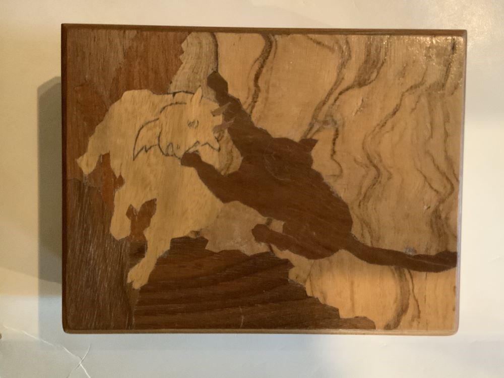
- Description
- A handmade (mortise and tenon construction) wooden box with feet and a hinged lid. The top has an inlaid wood design of a cougar attacking a mountain goat.
1 image
- Title
- Trinket Box
- Date
- 1950 – 1950
- Material
- wood; metal; plastic, polystyrene
- Dimensions
- 5.7 x 10.5 x 13.7 cm
- Description
- A handmade (mortise and tenon construction) wooden box with feet and a hinged lid. The top has an inlaid wood design of a cougar attacking a mountain goat.
- Credit
- Gift of Pearl Evelyn Moore, Banff, 1979
- Catalogue Number
- 102.04.0163
Images
This material is presented as originally created; it may contain outdated cultural descriptions and
potentially offensive content.
Read more.
[Dewar Creek 82F/16E, B.C.]
https://archives.whyte.org/en/permalink/catalogue23582
- Medium
- Library - Maps and blueprints (unannotated; published)
- Map
- Published Date
- 1951
- Publisher
- Department of National Defence
- Call Number
- NTS
- 82F/16E
- Publisher
- Department of National Defence
- Published Date
- 1951
- Physical Description
- 1 map : col
- Scale
- Scale: 1:50,000
- Relief: Contour interval 100 ft.
- Subjects
- Dewar Creek
- British Columbia
- Notes
- National Topographic System
- Accession Number
- 5500
- Call Number
- NTS
- 82F/16E
- Collection
- Archives Library
This material is presented as originally created; it may contain outdated cultural descriptions and
potentially offensive content.
Read more.
[Dewar Creek 82F/16W, B.C.]
https://archives.whyte.org/en/permalink/catalogue23583
- Medium
- Library - Maps and blueprints (unannotated; published)
- Map
- Published Date
- 1951
- Publisher
- Department of National Defence
- Call Number
- NTS
- 82F/16W
- Publisher
- Department of National Defence
- Published Date
- 1951
- Physical Description
- 1 map : col
- Scale
- Scale: 1:50,000
- Relief: Contour interval 100 ft.
- Subjects
- Dewar Creek
- British Columbia
- Notes
- National Topographic System
- Accession Number
- 5500
- Call Number
- NTS
- 82F/16W
- Collection
- Archives Library
This material is presented as originally created; it may contain outdated cultural descriptions and
potentially offensive content.
Read more.
National Geographic System
https://archives.whyte.org/en/permalink/catalogue23854
- Medium
- Library - Maps and blueprints (unannotated; published)
- Map
- Published Date
- 1951
- Publisher
- Department of National Defence
- Call Number
- NTS
- 82F/4W
- Publisher
- Department of National Defence
- Published Date
- 1951
- Physical Description
- 1 map : col
- Scale
- Scale: 1:50,000
- Relief: Contour interval 100 ft.
- Subjects
- Rossland-Trail
- British Columbia
- Accession Number
- 5500
- Call Number
- NTS
- 82F/4W
- Collection
- Archives Library
This material is presented as originally created; it may contain outdated cultural descriptions and
potentially offensive content.
Read more.
National Topographic System
https://archives.whyte.org/en/permalink/catalogue23855
- Medium
- Library - Maps and blueprints (unannotated; published)
- Map
- Published Date
- 1951
- Publisher
- Department of National Defence
- Call Number
- NTS
- 82F/4E
- Publisher
- Department of National Defence
- Published Date
- 1951
- Physical Description
- 1 map : col
- Scale
- Scale: 1:50,000
- Relief: Contour interval 100 ft.
- Subjects
- Rossland-Trail
- British Columbia
- Accession Number
- 5500
- Call Number
- NTS
- 82F/4E
- Collection
- Archives Library
This material is presented as originally created; it may contain outdated cultural descriptions and
potentially offensive content.
Read more.
[St. Mary Lake 82F/9 East - B.C.]
https://archives.whyte.org/en/permalink/catalogue23865
- Medium
- Library - Maps and blueprints (unannotated; published)
- Map
- Published Date
- 1951
- Publisher
- Department of National Defence
- Call Number
- NTS
- 82F/9E
- Publisher
- Department of National Defence
- Published Date
- 1951
- Physical Description
- Colour
- Scale
- Scale: 1:50,000
- Relief: Contour interval 100 ft
- Subjects
- St. Mary Lake 82F/9 East - B.C.
- Notes
- National Topographic System
- Accession Number
- 5500
- Call Number
- NTS
- 82F/9E
- Collection
- Archives Library
This material is presented as originally created; it may contain outdated cultural descriptions and
potentially offensive content.
Read more.
[St. Mary Lake 82F/9 West - B.C.]
https://archives.whyte.org/en/permalink/catalogue23866
- Medium
- Library - Maps and blueprints (unannotated; published)
- Map
- Published Date
- 1951
- Publisher
- Department of National Defence
- Call Number
- NTS
- 82F/9W
- Publisher
- Department of National Defence
- Published Date
- 1951
- Physical Description
- Colour
- Scale
- Scale: 1:50,000
- Relief: Contour interval 100 ft.
- Subjects
- St. Mary Lake 82F/9 West - B.C.
- Notes
- National Topographic System
- Accession Number
- 5500
- Call Number
- NTS
- 82F/9W
- Collection
- Archives Library
This material is presented as originally created; it may contain outdated cultural descriptions and
potentially offensive content.
Read more.
[Scuzzy Mountain 92H/13 East - B.C.]
https://archives.whyte.org/en/permalink/catalogue23874
- Medium
- Library - Maps and blueprints (unannotated; published)
- Map
- Published Date
- 1951
- Publisher
- Department of Mines and Technical Surveys
- Call Number
- NTS
- 92H/13E
- Publisher
- Department of Mines and Technical Surveys
- Published Date
- 1951
- Physical Description
- Colour
- Scale
- Scale: 1:50,000
- Relief: Contour interval 100 ft.
- Subjects
- Scuzzy Mountain 92H/13 East - B.C.
- Notes
- National Topographic System
- Accession Number
- 7000
- Call Number
- NTS
- 92H/13E
- Collection
- Archives Library
This material is presented as originally created; it may contain outdated cultural descriptions and
potentially offensive content.
Read more.
[Blueberry River]
https://archives.whyte.org/en/permalink/catalogue23970
- Medium
- Library - Maps and blueprints (unannotated; published)
- Map
- Published Date
- 1951
- Publisher
- Dept. of Mines & Technical Surveys
- Call Number
- NTS
- 94A/NW
- Publisher
- Dept. of Mines & Technical Surveys
- Published Date
- 1951
- Physical Description
- 1 map : col
- Scale
- Scale: 1:126,720
- Subjects
- Blueberry River
- Notes
- National Topographic System
- Accession Number
- 3000
- Call Number
- NTS
- 94A/NW
- Collection
- Archives Library
This material is presented as originally created; it may contain outdated cultural descriptions and
potentially offensive content.
Read more.
[Dawson Creek]
https://archives.whyte.org/en/permalink/catalogue23975
- Medium
- Library - Maps and blueprints (unannotated; published)
- Map
- Published Date
- 1951
- Publisher
- Dept. of Mines and Technical Surveys
- Call Number
- NTS
- 93P/NE
- Publisher
- Dept. of Mines and Technical Surveys
- Published Date
- 1951
- Physical Description
- 1 map : col
- Scale
- Scale: 1:126,720
- Subjects
- Dawson Creek
- Notes
- National Topographic System
- Accession Number
- 3000
- Call Number
- NTS
- 93P/NE
- Collection
- Archives Library
This material is presented as originally created; it may contain outdated cultural descriptions and
potentially offensive content.
Read more.
[Moberly Lake]
https://archives.whyte.org/en/permalink/catalogue23989
- Medium
- Library - Maps and blueprints (unannotated; published)
- Map
- Published Date
- 1951
- Publisher
- Dept. of Mines & Technical Surveys
- Call Number
- NTS
- 93P/NW
- Publisher
- Dept. of Mines & Technical Surveys
- Published Date
- 1951
- Physical Description
- 1 map : col
- Scale
- Scale: 1:126,720
- Subjects
- Moberly Lake
- Notes
- National Topographic System
- Accession Number
- 3000
- Call Number
- NTS
- 93P/NW
- Collection
- Archives Library
This material is presented as originally created; it may contain outdated cultural descriptions and
potentially offensive content.
Read more.
[Rose Prairie]
https://archives.whyte.org/en/permalink/catalogue23995
- Medium
- Library - Maps and blueprints (unannotated; published)
- Map
- Published Date
- 1951
- Publisher
- Dept. of Mines & Technical Surveys
- Call Number
- NTS
- 94A/NE
- Publisher
- Dept. of Mines & Technical Surveys
- Published Date
- 1951
- Physical Description
- 1 map : col
- Scale
- Scale: 1:126,720
- Subjects
- Rose Prairie
- Notes
- National Topographic System
- Accession Number
- 3000
- Call Number
- NTS
- 94A/NE
- Collection
- Archives Library
This material is presented as originally created; it may contain outdated cultural descriptions and
potentially offensive content.
Read more.
[Dezadeash 115 A - Yukon]
https://archives.whyte.org/en/permalink/catalogue24036
- Medium
- Library - Maps and blueprints (unannotated; published)
- Map
- Published Date
- 1951
- Publisher
- Dept. of Mines and Technical Surveys
- Call Number
- NTS
- 115A
- Publisher
- Dept. of Mines and Technical Surveys
- Published Date
- 1951
- Physical Description
- Colour
- Scale
- Scale: 1:250,000
- Relief: Contour Interval 500 ft.
- Subjects
- Dezadeash 115 A - Yukon
- Notes
- National Topographic System
- Accession Number
- 3000
- Call Number
- NTS
- 115A
- Collection
- Archives Library
This material is presented as originally created; it may contain outdated cultural descriptions and
potentially offensive content.
Read more.