Narrow Results By
Map of North America engraved to illustrate Mitchell's school and family geography
https://archives.whyte.org/en/permalink/catalogue24834
- Medium
- Library - Maps and blueprints (unannotated; published)
- Map
- Published Date
- 1852
- Publisher
- Pennsylvania : S. Augustus Mitchell
- Call Number
- C13.4.6
- Publisher
- Pennsylvania : S. Augustus Mitchell
- Published Date
- 1852
- Physical Description
- 1 map : col
- Scale
- 1 inch = ca 600 miles
- Subjects
- North America
- Hooker, Mount
- Brown, Mount
- Notes
- Map shows Mts. Hooker and Brown, and gives altitudes of same
- Accession Number
- 3612
- Call Number
- C13.4.6
- Collection
- Archives Library
This material is presented as originally created; it may contain outdated cultural descriptions and
potentially offensive content.
Read more.
Stations of the Church Missionary Society
https://archives.whyte.org/en/permalink/catalogue21486
- Medium
- Library - Maps and blueprints (unannotated; published)
- Map
- Published Date
- 1852
- Call Number
- C12-1.10
- Published Date
- 1852
- Subjects
- Hudson's Bay Company's Territories
- Notes
- Route of the Bishop of Montreal from Quebec to Red River in 1844
- Photostatic copy from Public Archives
- Accession Number
- 675
- Call Number
- C12-1.10
- Collection
- Archives Library
This material is presented as originally created; it may contain outdated cultural descriptions and
potentially offensive content.
Read more.
Danubian Principalities
https://archives.whyte.org/en/permalink/catalogue21541
- Medium
- Library - Maps and blueprints (unannotated; published)
- Map
- Published Date
- 1854
- Publisher
- W and A.K. Johnston, Edinburgh
- Call Number
- C13-12.17
- Publisher
- W and A.K. Johnston, Edinburgh
- Published Date
- 1854
- Subjects
- Europe - Central & Eastern
- Accession Number
- 400
- Call Number
- C13-12.17
- Collection
- Archives Library
This material is presented as originally created; it may contain outdated cultural descriptions and
potentially offensive content.
Read more.
Northwestern United States and Neighbouring Canadian Provinces
https://archives.whyte.org/en/permalink/catalogue24810
- Medium
- Library - Maps and blueprints (unannotated; published)
- Map
- Published Date
- 1950
- Publisher
- National Geographic Society
- Call Number
- C13-1.1(b)
- Publisher
- National Geographic Society
- Published Date
- 1950
- Scale
- Scale: 39.46 miles to 1 inch
- Relief: Bench marks
- Subjects
- Northwestern United States
- Accession Number
- 495
- Call Number
- C13-1.1(b)
- Collection
- Archives Library
This material is presented as originally created; it may contain outdated cultural descriptions and
potentially offensive content.
Read more.
Plan of lots 1A, 2A & 4A south of Bow River, Banff, Alberta
https://archives.whyte.org/en/permalink/catalogue23265
- Medium
- Library - Maps and blueprints (unannotated; published)
- Map
- Published Date
- 1950
- Publisher
- Banff: Resident Engineer's Office
- Call Number
- C4-1.10a
- Publisher
- Banff: Resident Engineer's Office
- Published Date
- 1950
- Physical Description
- 1 map : blueprint
- Scale
- Scale: 1 inch = 40 feet
- Subjects
- Banff townsite
- Notes
- Signed: J.R.W.
- Bearings shown refer to plan approved . . . 10th May, 1913
- Accession Number
- 3500
- Call Number
- C4-1.10a
- Collection
- Archives Library
This material is presented as originally created; it may contain outdated cultural descriptions and
potentially offensive content.
Read more.
[Mistaya 82N/NE, Alta.-B.C.]
https://archives.whyte.org/en/permalink/catalogue23988
- Medium
- Library - Maps and blueprints (unannotated; published)
- Map
- Published Date
- 1950
- Publisher
- Dept. of Mines and Technical Surveys
- Call Number
- NTS
- 82N/NE
- Publisher
- Dept. of Mines and Technical Surveys
- Published Date
- 1950
- Physical Description
- 1 map : col
- Scale
- Scale: 1:126,720
- Relief: Contour Interval 200 ft.
- Subjects
- Mistaya
- British Columbia
- Notes
- National Topographic System
- Accession Number
- 3000
- Call Number
- NTS
- 82N/NE
- Collection
- Archives Library
This material is presented as originally created; it may contain outdated cultural descriptions and
potentially offensive content.
Read more.
[McDame 104 P - B.C.]
https://archives.whyte.org/en/permalink/catalogue24090
- Medium
- Library - Maps and blueprints (unannotated; published)
- Map
- Published Date
- 1950
- Publisher
- Dept. of Mines and Technical Surveys
- Call Number
- NTS
- 104P
- Publisher
- Dept. of Mines and Technical Surveys
- Published Date
- 1950
- Physical Description
- 1 map : col
- Scale
- Scale: 1:250,000
- Relief: Contour interval 500 ft.
- Subjects
- McDame
- British Columbia
- Accession Number
- 3000
- Call Number
- NTS
- 104P
- Collection
- Archives Library
This material is presented as originally created; it may contain outdated cultural descriptions and
potentially offensive content.
Read more.
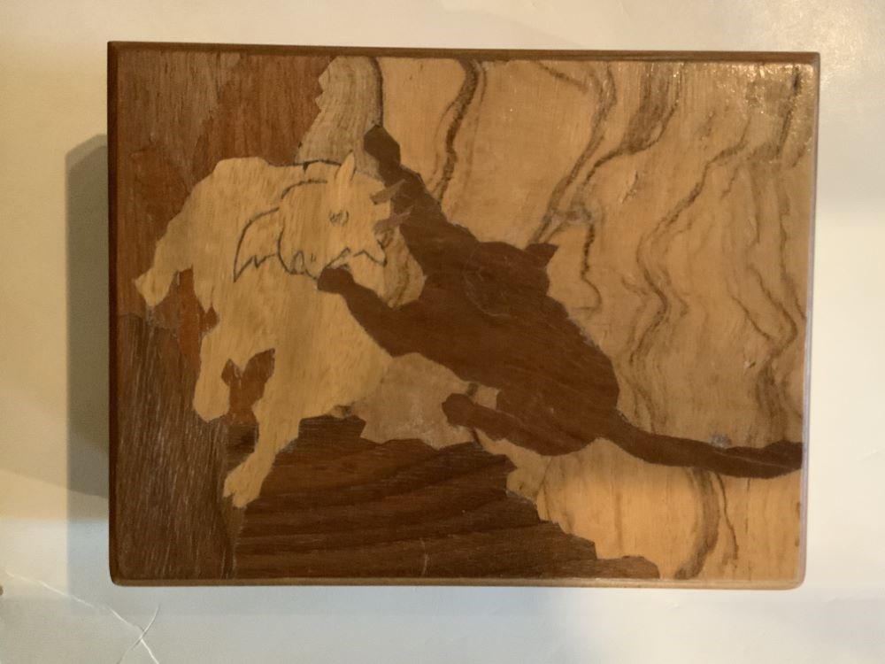
- Date
- 1950 – 1950
- Material
- wood; metal; plastic, polystyrene
- Catalogue Number
- 102.04.0163
- Description
- A handmade (mortise and tenon construction) wooden box with feet and a hinged lid. The top has an inlaid wood design of a cougar attacking a mountain goat.
1 image
- Title
- Trinket Box
- Date
- 1950 – 1950
- Material
- wood; metal; plastic, polystyrene
- Dimensions
- 5.7 x 10.5 x 13.7 cm
- Description
- A handmade (mortise and tenon construction) wooden box with feet and a hinged lid. The top has an inlaid wood design of a cougar attacking a mountain goat.
- Credit
- Gift of Pearl Evelyn Moore, Banff, 1979
- Catalogue Number
- 102.04.0163
Images
This material is presented as originally created; it may contain outdated cultural descriptions and
potentially offensive content.
Read more.
Royal visit commemorative place mats
https://archives.whyte.org/en/permalink/descriptions54764
- Part Of
- Luxton family fonds
- Scope & Content
- File consists of 11 identical decorative paper place mats and one cardboard poster depicting Princess Elizabeth and Prince Philip of England, as well as the coat of arms for Canada and its 10 provinces with "Welcome to Canada" written across the bottom. Content pertains to Elizabeth and Philip's ro…
- Date Range
- 1951
- Reference Code
- LUX / II / F1 / 46
- Description Level
- 5 / File
- GMD
- Textual record
- Published record
- Part Of
- Luxton family fonds
- Description Level
- 5 / File
- Fonds Number
- LUX
- Series
- LUX / II / F : Collected material
- Sous-Fonds
- LUX / II : Eleanor Luxton sous-fonds
- Sub-Series
- LUX / II / F1 : Textual
- Accession Number
- LUX
- Reference Code
- LUX / II / F1 / 46
- Date Range
- 1951
- Physical Description
- 0.2 cm of textual records (12 items ; 25 x 38 cm)
- Scope & Content
- File consists of 11 identical decorative paper place mats and one cardboard poster depicting Princess Elizabeth and Prince Philip of England, as well as the coat of arms for Canada and its 10 provinces with "Welcome to Canada" written across the bottom. Content pertains to Elizabeth and Philip's royal visit to Canada in 1951. Items are in original paper envelope with a similar design printed across the front. Back of envelope includes Shell Gasoline logo and stamp for Shell gas station in Banff.
- Subject Access
- Royal Visit
- Royalty
- Souvenir
- Government
- Advertising
- Natural resources
- Geographic Access
- Canada
- Alberta
- Banff
- Reproduction Restrictions
- Restrictions may apply
- Language
- English
- Title Source
- Title based on contents of file
- Processing Status
- Processed
This material is presented as originally created; it may contain outdated cultural descriptions and
potentially offensive content.
Read more.
[Prince Albert Park]
https://archives.whyte.org/en/permalink/catalogue23233
- Medium
- Library - Maps and blueprints (unannotated; published)
- Map
- Published Date
- 1951
- Publisher
- Dept. of Mines and Technical Surveys
- Call Number
- C2-9.2
- Publisher
- Dept. of Mines and Technical Surveys
- Published Date
- 1951
- Physical Description
- 1 map : col
- Scale
- Scale: 1 inch : 2.37 miles
- Bench marks
- Subjects
- Prince Albert National Park
- Accession Number
- 718
- Call Number
- C2-9.2
- Collection
- Archives Library
This material is presented as originally created; it may contain outdated cultural descriptions and
potentially offensive content.
Read more.
[Dewar Creek 82F/16E, B.C.]
https://archives.whyte.org/en/permalink/catalogue23582
- Medium
- Library - Maps and blueprints (unannotated; published)
- Map
- Published Date
- 1951
- Publisher
- Department of National Defence
- Call Number
- NTS
- 82F/16E
- Publisher
- Department of National Defence
- Published Date
- 1951
- Physical Description
- 1 map : col
- Scale
- Scale: 1:50,000
- Relief: Contour interval 100 ft.
- Subjects
- Dewar Creek
- British Columbia
- Notes
- National Topographic System
- Accession Number
- 5500
- Call Number
- NTS
- 82F/16E
- Collection
- Archives Library
This material is presented as originally created; it may contain outdated cultural descriptions and
potentially offensive content.
Read more.
[Dewar Creek 82F/16W, B.C.]
https://archives.whyte.org/en/permalink/catalogue23583
- Medium
- Library - Maps and blueprints (unannotated; published)
- Map
- Published Date
- 1951
- Publisher
- Department of National Defence
- Call Number
- NTS
- 82F/16W
- Publisher
- Department of National Defence
- Published Date
- 1951
- Physical Description
- 1 map : col
- Scale
- Scale: 1:50,000
- Relief: Contour interval 100 ft.
- Subjects
- Dewar Creek
- British Columbia
- Notes
- National Topographic System
- Accession Number
- 5500
- Call Number
- NTS
- 82F/16W
- Collection
- Archives Library
This material is presented as originally created; it may contain outdated cultural descriptions and
potentially offensive content.
Read more.
National Geographic System
https://archives.whyte.org/en/permalink/catalogue23854
- Medium
- Library - Maps and blueprints (unannotated; published)
- Map
- Published Date
- 1951
- Publisher
- Department of National Defence
- Call Number
- NTS
- 82F/4W
- Publisher
- Department of National Defence
- Published Date
- 1951
- Physical Description
- 1 map : col
- Scale
- Scale: 1:50,000
- Relief: Contour interval 100 ft.
- Subjects
- Rossland-Trail
- British Columbia
- Accession Number
- 5500
- Call Number
- NTS
- 82F/4W
- Collection
- Archives Library
This material is presented as originally created; it may contain outdated cultural descriptions and
potentially offensive content.
Read more.
National Topographic System
https://archives.whyte.org/en/permalink/catalogue23855
- Medium
- Library - Maps and blueprints (unannotated; published)
- Map
- Published Date
- 1951
- Publisher
- Department of National Defence
- Call Number
- NTS
- 82F/4E
- Publisher
- Department of National Defence
- Published Date
- 1951
- Physical Description
- 1 map : col
- Scale
- Scale: 1:50,000
- Relief: Contour interval 100 ft.
- Subjects
- Rossland-Trail
- British Columbia
- Accession Number
- 5500
- Call Number
- NTS
- 82F/4E
- Collection
- Archives Library
This material is presented as originally created; it may contain outdated cultural descriptions and
potentially offensive content.
Read more.
[St. Mary Lake 82F/9 East - B.C.]
https://archives.whyte.org/en/permalink/catalogue23865
- Medium
- Library - Maps and blueprints (unannotated; published)
- Map
- Published Date
- 1951
- Publisher
- Department of National Defence
- Call Number
- NTS
- 82F/9E
- Publisher
- Department of National Defence
- Published Date
- 1951
- Physical Description
- Colour
- Scale
- Scale: 1:50,000
- Relief: Contour interval 100 ft
- Subjects
- St. Mary Lake 82F/9 East - B.C.
- Notes
- National Topographic System
- Accession Number
- 5500
- Call Number
- NTS
- 82F/9E
- Collection
- Archives Library
This material is presented as originally created; it may contain outdated cultural descriptions and
potentially offensive content.
Read more.
[St. Mary Lake 82F/9 West - B.C.]
https://archives.whyte.org/en/permalink/catalogue23866
- Medium
- Library - Maps and blueprints (unannotated; published)
- Map
- Published Date
- 1951
- Publisher
- Department of National Defence
- Call Number
- NTS
- 82F/9W
- Publisher
- Department of National Defence
- Published Date
- 1951
- Physical Description
- Colour
- Scale
- Scale: 1:50,000
- Relief: Contour interval 100 ft.
- Subjects
- St. Mary Lake 82F/9 West - B.C.
- Notes
- National Topographic System
- Accession Number
- 5500
- Call Number
- NTS
- 82F/9W
- Collection
- Archives Library
This material is presented as originally created; it may contain outdated cultural descriptions and
potentially offensive content.
Read more.
[Scuzzy Mountain 92H/13 East - B.C.]
https://archives.whyte.org/en/permalink/catalogue23874
- Medium
- Library - Maps and blueprints (unannotated; published)
- Map
- Published Date
- 1951
- Publisher
- Department of Mines and Technical Surveys
- Call Number
- NTS
- 92H/13E
- Publisher
- Department of Mines and Technical Surveys
- Published Date
- 1951
- Physical Description
- Colour
- Scale
- Scale: 1:50,000
- Relief: Contour interval 100 ft.
- Subjects
- Scuzzy Mountain 92H/13 East - B.C.
- Notes
- National Topographic System
- Accession Number
- 7000
- Call Number
- NTS
- 92H/13E
- Collection
- Archives Library
This material is presented as originally created; it may contain outdated cultural descriptions and
potentially offensive content.
Read more.
[Blueberry River]
https://archives.whyte.org/en/permalink/catalogue23970
- Medium
- Library - Maps and blueprints (unannotated; published)
- Map
- Published Date
- 1951
- Publisher
- Dept. of Mines & Technical Surveys
- Call Number
- NTS
- 94A/NW
- Publisher
- Dept. of Mines & Technical Surveys
- Published Date
- 1951
- Physical Description
- 1 map : col
- Scale
- Scale: 1:126,720
- Subjects
- Blueberry River
- Notes
- National Topographic System
- Accession Number
- 3000
- Call Number
- NTS
- 94A/NW
- Collection
- Archives Library
This material is presented as originally created; it may contain outdated cultural descriptions and
potentially offensive content.
Read more.
[Dawson Creek]
https://archives.whyte.org/en/permalink/catalogue23975
- Medium
- Library - Maps and blueprints (unannotated; published)
- Map
- Published Date
- 1951
- Publisher
- Dept. of Mines and Technical Surveys
- Call Number
- NTS
- 93P/NE
- Publisher
- Dept. of Mines and Technical Surveys
- Published Date
- 1951
- Physical Description
- 1 map : col
- Scale
- Scale: 1:126,720
- Subjects
- Dawson Creek
- Notes
- National Topographic System
- Accession Number
- 3000
- Call Number
- NTS
- 93P/NE
- Collection
- Archives Library
This material is presented as originally created; it may contain outdated cultural descriptions and
potentially offensive content.
Read more.
[Moberly Lake]
https://archives.whyte.org/en/permalink/catalogue23989
- Medium
- Library - Maps and blueprints (unannotated; published)
- Map
- Published Date
- 1951
- Publisher
- Dept. of Mines & Technical Surveys
- Call Number
- NTS
- 93P/NW
- Publisher
- Dept. of Mines & Technical Surveys
- Published Date
- 1951
- Physical Description
- 1 map : col
- Scale
- Scale: 1:126,720
- Subjects
- Moberly Lake
- Notes
- National Topographic System
- Accession Number
- 3000
- Call Number
- NTS
- 93P/NW
- Collection
- Archives Library
This material is presented as originally created; it may contain outdated cultural descriptions and
potentially offensive content.
Read more.