Narrow Results By
- Luxton family fonds 20
- Nicholas Morant fonds 17
- Girl Guides of Canada, Banff fonds 3
- Helen Fulmer Wells fonds 3
- Tom Wilson family fonds 3
- Alpine Club of Canada fonds 2
- Andy Russell fonds 2
- Bill Waterworth fonds 2
- Charlotte Tuerck fonds 2
- Dorothy Wardle fonds 2
- Ford Family fonds 2
- George K. K. (Tommy) Link fonds 2
Map showing the communication of the Lakes and Rivers between Lake Superior and Slave Lake in North America
https://archives.whyte.org/en/permalink/catalogue21338
- Medium
- Library - Maps and blueprints (unannotated; published)
- Map
- Published Date
- 1790
- Publisher
- Gent Mag.
- Call Number
- C5-5.8
- Publisher
- Gent Mag.
- Published Date
- 1790
- Subjects
- Hydrological Maps Canada
- Notes
- From a copy - Gent Mag. 1790
- Accession Number
- 11,500
- Call Number
- C5-5.8
- Collection
- Archives Library
This material is presented as originally created; it may contain outdated cultural descriptions and
potentially offensive content.
Read more.
Travels through Western Canada from April, 1773 to March, 1790
https://archives.whyte.org/en/permalink/catalogue21485
- Medium
- Library - Maps and blueprints (unannotated; published)
- Map
- Published Date
- 1790
- Call Number
- C12-1.9
- Published Date
- 1790
- Subjects
- Peter Pond's Travels
- Notes
- Photostatic copy from Public Archives
- Accession Number
- 675
- Call Number
- C12-1.9
- Collection
- Archives Library
This material is presented as originally created; it may contain outdated cultural descriptions and
potentially offensive content.
Read more.
A map showing the communication of the lakes and rivers between Lake Superior and Slave Lake in North America
https://archives.whyte.org/en/permalink/catalogue24545
- Medium
- Library - Maps and blueprints (unannotated; published)
- Map
- Published Date
- 1790
- Publisher
- Gent. Mag.
- Call Number
- C11-1.7
- Publisher
- Gent. Mag.
- Published Date
- 1790
- Physical Description
- 1 map
- Scale
- Scale indeterminable
- Subjects
- Rivers
- The West, Canadian
- Accession Number
- 12,500
- Call Number
- C11-1.7
- Collection
- Archives Library
This material is presented as originally created; it may contain outdated cultural descriptions and
potentially offensive content.
Read more.
Map of North America engraved to illustrate Mitchell's school and family geography
https://archives.whyte.org/en/permalink/catalogue24834
- Medium
- Library - Maps and blueprints (unannotated; published)
- Map
- Published Date
- 1852
- Publisher
- Pennsylvania : S. Augustus Mitchell
- Call Number
- C13.4.6
- Publisher
- Pennsylvania : S. Augustus Mitchell
- Published Date
- 1852
- Physical Description
- 1 map : col
- Scale
- 1 inch = ca 600 miles
- Subjects
- North America
- Hooker, Mount
- Brown, Mount
- Notes
- Map shows Mts. Hooker and Brown, and gives altitudes of same
- Accession Number
- 3612
- Call Number
- C13.4.6
- Collection
- Archives Library
This material is presented as originally created; it may contain outdated cultural descriptions and
potentially offensive content.
Read more.
Stations of the Church Missionary Society
https://archives.whyte.org/en/permalink/catalogue21486
- Medium
- Library - Maps and blueprints (unannotated; published)
- Map
- Published Date
- 1852
- Call Number
- C12-1.10
- Published Date
- 1852
- Subjects
- Hudson's Bay Company's Territories
- Notes
- Route of the Bishop of Montreal from Quebec to Red River in 1844
- Photostatic copy from Public Archives
- Accession Number
- 675
- Call Number
- C12-1.10
- Collection
- Archives Library
This material is presented as originally created; it may contain outdated cultural descriptions and
potentially offensive content.
Read more.
Danubian Principalities
https://archives.whyte.org/en/permalink/catalogue21541
- Medium
- Library - Maps and blueprints (unannotated; published)
- Map
- Published Date
- 1854
- Publisher
- W and A.K. Johnston, Edinburgh
- Call Number
- C13-12.17
- Publisher
- W and A.K. Johnston, Edinburgh
- Published Date
- 1854
- Subjects
- Europe - Central & Eastern
- Accession Number
- 400
- Call Number
- C13-12.17
- Collection
- Archives Library
This material is presented as originally created; it may contain outdated cultural descriptions and
potentially offensive content.
Read more.
Northwestern United States and Neighbouring Canadian Provinces
https://archives.whyte.org/en/permalink/catalogue24810
- Medium
- Library - Maps and blueprints (unannotated; published)
- Map
- Published Date
- 1950
- Publisher
- National Geographic Society
- Call Number
- C13-1.1(b)
- Publisher
- National Geographic Society
- Published Date
- 1950
- Scale
- Scale: 39.46 miles to 1 inch
- Relief: Bench marks
- Subjects
- Northwestern United States
- Accession Number
- 495
- Call Number
- C13-1.1(b)
- Collection
- Archives Library
This material is presented as originally created; it may contain outdated cultural descriptions and
potentially offensive content.
Read more.
Plan of lots 1A, 2A & 4A south of Bow River, Banff, Alberta
https://archives.whyte.org/en/permalink/catalogue23265
- Medium
- Library - Maps and blueprints (unannotated; published)
- Map
- Published Date
- 1950
- Publisher
- Banff: Resident Engineer's Office
- Call Number
- C4-1.10a
- Publisher
- Banff: Resident Engineer's Office
- Published Date
- 1950
- Physical Description
- 1 map : blueprint
- Scale
- Scale: 1 inch = 40 feet
- Subjects
- Banff townsite
- Notes
- Signed: J.R.W.
- Bearings shown refer to plan approved . . . 10th May, 1913
- Accession Number
- 3500
- Call Number
- C4-1.10a
- Collection
- Archives Library
This material is presented as originally created; it may contain outdated cultural descriptions and
potentially offensive content.
Read more.
[Mistaya 82N/NE, Alta.-B.C.]
https://archives.whyte.org/en/permalink/catalogue23988
- Medium
- Library - Maps and blueprints (unannotated; published)
- Map
- Published Date
- 1950
- Publisher
- Dept. of Mines and Technical Surveys
- Call Number
- NTS
- 82N/NE
- Publisher
- Dept. of Mines and Technical Surveys
- Published Date
- 1950
- Physical Description
- 1 map : col
- Scale
- Scale: 1:126,720
- Relief: Contour Interval 200 ft.
- Subjects
- Mistaya
- British Columbia
- Notes
- National Topographic System
- Accession Number
- 3000
- Call Number
- NTS
- 82N/NE
- Collection
- Archives Library
This material is presented as originally created; it may contain outdated cultural descriptions and
potentially offensive content.
Read more.
[McDame 104 P - B.C.]
https://archives.whyte.org/en/permalink/catalogue24090
- Medium
- Library - Maps and blueprints (unannotated; published)
- Map
- Published Date
- 1950
- Publisher
- Dept. of Mines and Technical Surveys
- Call Number
- NTS
- 104P
- Publisher
- Dept. of Mines and Technical Surveys
- Published Date
- 1950
- Physical Description
- 1 map : col
- Scale
- Scale: 1:250,000
- Relief: Contour interval 500 ft.
- Subjects
- McDame
- British Columbia
- Accession Number
- 3000
- Call Number
- NTS
- 104P
- Collection
- Archives Library
This material is presented as originally created; it may contain outdated cultural descriptions and
potentially offensive content.
Read more.
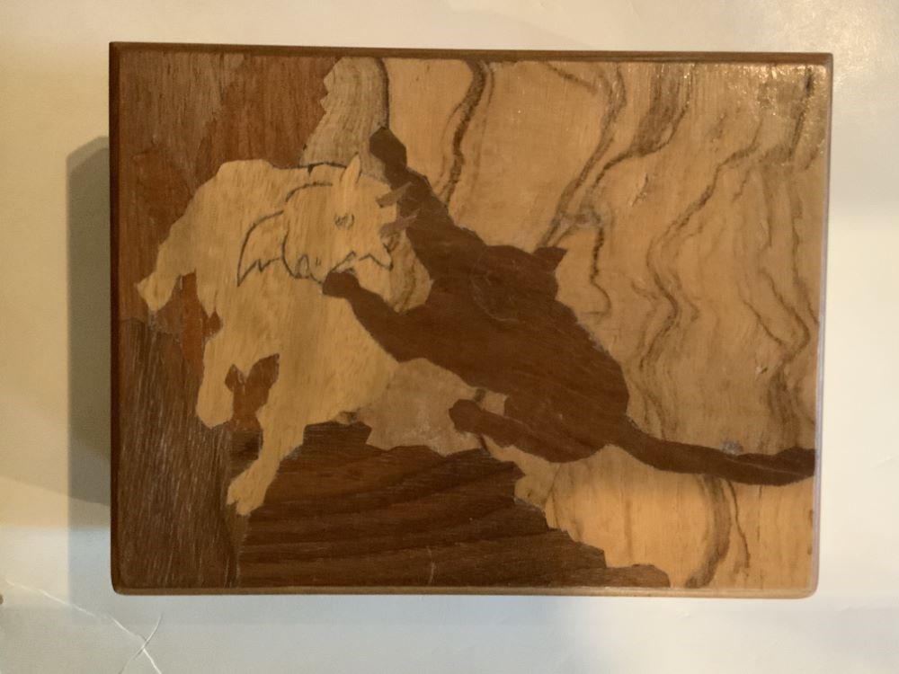
- Date
- 1950 – 1950
- Material
- wood; metal; plastic, polystyrene
- Catalogue Number
- 102.04.0163
- Description
- A handmade (mortise and tenon construction) wooden box with feet and a hinged lid. The top has an inlaid wood design of a cougar attacking a mountain goat.
1 image
- Title
- Trinket Box
- Date
- 1950 – 1950
- Material
- wood; metal; plastic, polystyrene
- Dimensions
- 5.7 x 10.5 x 13.7 cm
- Description
- A handmade (mortise and tenon construction) wooden box with feet and a hinged lid. The top has an inlaid wood design of a cougar attacking a mountain goat.
- Credit
- Gift of Pearl Evelyn Moore, Banff, 1979
- Catalogue Number
- 102.04.0163
Images
This material is presented as originally created; it may contain outdated cultural descriptions and
potentially offensive content.
Read more.
The Selkirk Range Text and Maps
https://archives.whyte.org/en/permalink/descriptions54163
- Part Of
- Nicholas Morant fonds
- Scope & Content
- File consists of 2 volumes, 1 textual and 1 cartographic, from 'The Selkirk Range British Columbia'. Volume 1 pertains to a textual account of the Selkirk region; volume 2 pertains to a collection of various topographical maps of the Selkirk region. Volume 1 is signed by Emmeline Wheeler.
- Date Range
- 1951
- Reference Code
- M300 / III / D / 5 / 52 to 53
- Description Level
- 5 / File
- GMD
- Textual record
- Private record
- Map
- Part Of
- Nicholas Morant fonds
- Description Level
- 5 / File
- Fonds Number
- M300 / S20 / V500
- Sous-Fonds
- M300
- Sub-Series
- M300 / III / D / 5 : Personal Interest and Gifts
- Accession Number
- 7784
- Reference Code
- M300 / III / D / 5 / 52 to 53
- Responsibility
- Produced by A.O. Wheeler
- Date Range
- 1951
- Physical Description
- Textual record: book & Cartographic records: maps
- Scope & Content
- File consists of 2 volumes, 1 textual and 1 cartographic, from 'The Selkirk Range British Columbia'. Volume 1 pertains to a textual account of the Selkirk region; volume 2 pertains to a collection of various topographical maps of the Selkirk region. Volume 1 is signed by Emmeline Wheeler.
- Storage Range
- In file box M300 / III / D / 5 / 52 to M300 / III / D / 5 / 53.
- Name Access
- Wheeler, A.O.
- Geographic Access
- Canada
- Canadian Rocky Mountains
- Selkirks
- Access Restrictions
- Items in this file are not to be accessed or distributed without the explicit permission of their identified copyright owners.
- Reproduction Restrictions
- Items in this file are not to be reproduced without the explicit permission of their identified copyright owners.
- Language
- English
- Creator
- A.O. Wheeler
- Title Source
- Title based on contents of file
- Processing Status
- Processed
This material is presented as originally created; it may contain outdated cultural descriptions and
potentially offensive content.
Read more.
[Prince Albert Park]
https://archives.whyte.org/en/permalink/catalogue23233
- Medium
- Library - Maps and blueprints (unannotated; published)
- Map
- Published Date
- 1951
- Publisher
- Dept. of Mines and Technical Surveys
- Call Number
- C2-9.2
- Publisher
- Dept. of Mines and Technical Surveys
- Published Date
- 1951
- Physical Description
- 1 map : col
- Scale
- Scale: 1 inch : 2.37 miles
- Bench marks
- Subjects
- Prince Albert National Park
- Accession Number
- 718
- Call Number
- C2-9.2
- Collection
- Archives Library
This material is presented as originally created; it may contain outdated cultural descriptions and
potentially offensive content.
Read more.
[Dewar Creek 82F/16E, B.C.]
https://archives.whyte.org/en/permalink/catalogue23582
- Medium
- Library - Maps and blueprints (unannotated; published)
- Map
- Published Date
- 1951
- Publisher
- Department of National Defence
- Call Number
- NTS
- 82F/16E
- Publisher
- Department of National Defence
- Published Date
- 1951
- Physical Description
- 1 map : col
- Scale
- Scale: 1:50,000
- Relief: Contour interval 100 ft.
- Subjects
- Dewar Creek
- British Columbia
- Notes
- National Topographic System
- Accession Number
- 5500
- Call Number
- NTS
- 82F/16E
- Collection
- Archives Library
This material is presented as originally created; it may contain outdated cultural descriptions and
potentially offensive content.
Read more.
[Dewar Creek 82F/16W, B.C.]
https://archives.whyte.org/en/permalink/catalogue23583
- Medium
- Library - Maps and blueprints (unannotated; published)
- Map
- Published Date
- 1951
- Publisher
- Department of National Defence
- Call Number
- NTS
- 82F/16W
- Publisher
- Department of National Defence
- Published Date
- 1951
- Physical Description
- 1 map : col
- Scale
- Scale: 1:50,000
- Relief: Contour interval 100 ft.
- Subjects
- Dewar Creek
- British Columbia
- Notes
- National Topographic System
- Accession Number
- 5500
- Call Number
- NTS
- 82F/16W
- Collection
- Archives Library
This material is presented as originally created; it may contain outdated cultural descriptions and
potentially offensive content.
Read more.
National Geographic System
https://archives.whyte.org/en/permalink/catalogue23854
- Medium
- Library - Maps and blueprints (unannotated; published)
- Map
- Published Date
- 1951
- Publisher
- Department of National Defence
- Call Number
- NTS
- 82F/4W
- Publisher
- Department of National Defence
- Published Date
- 1951
- Physical Description
- 1 map : col
- Scale
- Scale: 1:50,000
- Relief: Contour interval 100 ft.
- Subjects
- Rossland-Trail
- British Columbia
- Accession Number
- 5500
- Call Number
- NTS
- 82F/4W
- Collection
- Archives Library
This material is presented as originally created; it may contain outdated cultural descriptions and
potentially offensive content.
Read more.
National Topographic System
https://archives.whyte.org/en/permalink/catalogue23855
- Medium
- Library - Maps and blueprints (unannotated; published)
- Map
- Published Date
- 1951
- Publisher
- Department of National Defence
- Call Number
- NTS
- 82F/4E
- Publisher
- Department of National Defence
- Published Date
- 1951
- Physical Description
- 1 map : col
- Scale
- Scale: 1:50,000
- Relief: Contour interval 100 ft.
- Subjects
- Rossland-Trail
- British Columbia
- Accession Number
- 5500
- Call Number
- NTS
- 82F/4E
- Collection
- Archives Library
This material is presented as originally created; it may contain outdated cultural descriptions and
potentially offensive content.
Read more.
[St. Mary Lake 82F/9 East - B.C.]
https://archives.whyte.org/en/permalink/catalogue23865
- Medium
- Library - Maps and blueprints (unannotated; published)
- Map
- Published Date
- 1951
- Publisher
- Department of National Defence
- Call Number
- NTS
- 82F/9E
- Publisher
- Department of National Defence
- Published Date
- 1951
- Physical Description
- Colour
- Scale
- Scale: 1:50,000
- Relief: Contour interval 100 ft
- Subjects
- St. Mary Lake 82F/9 East - B.C.
- Notes
- National Topographic System
- Accession Number
- 5500
- Call Number
- NTS
- 82F/9E
- Collection
- Archives Library
This material is presented as originally created; it may contain outdated cultural descriptions and
potentially offensive content.
Read more.
[St. Mary Lake 82F/9 West - B.C.]
https://archives.whyte.org/en/permalink/catalogue23866
- Medium
- Library - Maps and blueprints (unannotated; published)
- Map
- Published Date
- 1951
- Publisher
- Department of National Defence
- Call Number
- NTS
- 82F/9W
- Publisher
- Department of National Defence
- Published Date
- 1951
- Physical Description
- Colour
- Scale
- Scale: 1:50,000
- Relief: Contour interval 100 ft.
- Subjects
- St. Mary Lake 82F/9 West - B.C.
- Notes
- National Topographic System
- Accession Number
- 5500
- Call Number
- NTS
- 82F/9W
- Collection
- Archives Library
This material is presented as originally created; it may contain outdated cultural descriptions and
potentially offensive content.
Read more.
[Scuzzy Mountain 92H/13 East - B.C.]
https://archives.whyte.org/en/permalink/catalogue23874
- Medium
- Library - Maps and blueprints (unannotated; published)
- Map
- Published Date
- 1951
- Publisher
- Department of Mines and Technical Surveys
- Call Number
- NTS
- 92H/13E
- Publisher
- Department of Mines and Technical Surveys
- Published Date
- 1951
- Physical Description
- Colour
- Scale
- Scale: 1:50,000
- Relief: Contour interval 100 ft.
- Subjects
- Scuzzy Mountain 92H/13 East - B.C.
- Notes
- National Topographic System
- Accession Number
- 7000
- Call Number
- NTS
- 92H/13E
- Collection
- Archives Library
This material is presented as originally created; it may contain outdated cultural descriptions and
potentially offensive content.
Read more.