Narrow Results By
- Vaux family fonds 163
- Peter and Catharine Whyte fonds 111
- Boorne and May fonds 106
- Luxton family fonds 63
- Moore family fonds 30
- George Paris fonds 12
- Kidney family fonds 9
- Arthur A. Goodsell fonds 8
- Nicholas Morant fonds 8
- Professional photographers collection 7
- James Irving McLeod fonds 6
- Jim Brewster family fonds 5
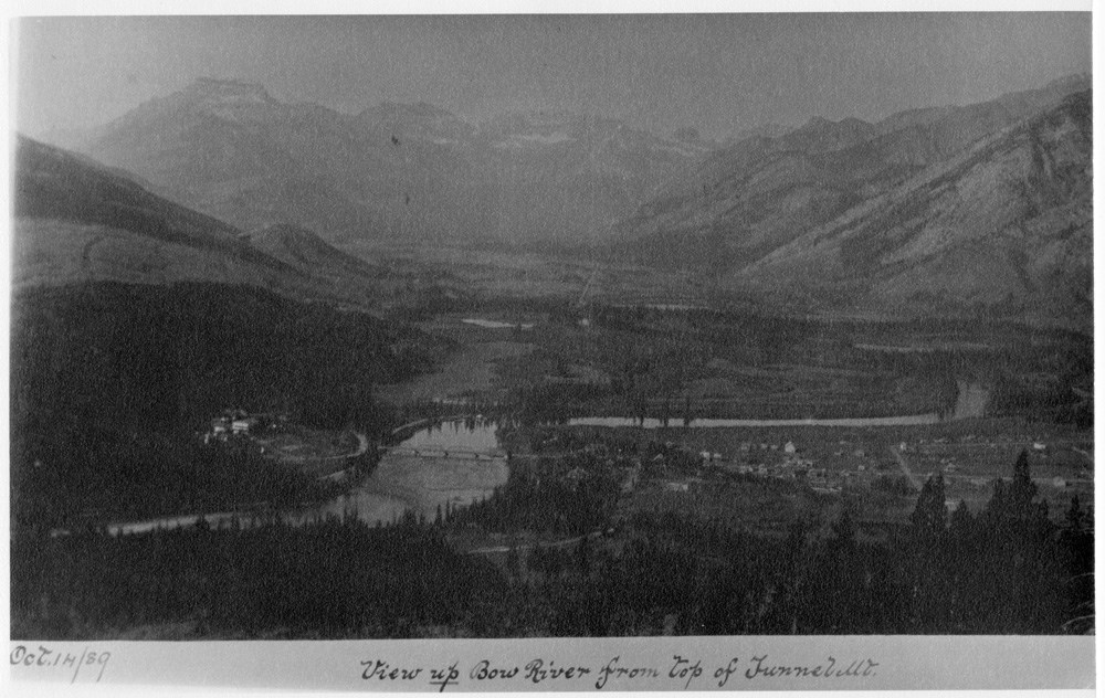
View up Bow River from top of Tunnel Mt.
https://archives.whyte.org/en/permalink/descriptions52036
- Part Of
- Peter and Catharine Whyte fonds
- Scope & Content
- Image of Banff and Bow River as seen from Tunnel Mountain - caption along bottom in black ink reads "Oct. 14/89 - View up Bow River from top of Tunnel Mt."
- Date Range
- 1899
- Reference Code
- V683 / III / A / 3 / PA - 256
- Description Level
- 6 / Item
- GMD
- Photograph
1 image
- Part Of
- Peter and Catharine Whyte fonds
- Description Level
- 6 / Item
- Fonds Number
- M36 / V683 / S37
- Series
- V683 / III / A / 3 : Peter and Catharine Whyte: Various Views of Banff and Area
- Sous-Fonds
- V683
- Accession Number
- .
- Reference Code
- V683 / III / A / 3 / PA - 256
- GMD
- Photograph
- Date Range
- 1899
- Physical Description
- Photograph: 1 print ; b&w.
- Scope & Content
- Image of Banff and Bow River as seen from Tunnel Mountain - caption along bottom in black ink reads "Oct. 14/89 - View up Bow River from top of Tunnel Mt."
- Subject Access
- Banff townsite
- Tunnel Mountain lookout
- Geographic Access
- Banff
- Language
- English
- Title Source
- Title based on item
- Processing Status
- Processed
Images
This material is presented as originally created; it may contain outdated cultural descriptions and
potentially offensive content.
Read more.
Pearl and George
https://archives.whyte.org/en/permalink/descriptions48866
- Part Of
- Moore family fonds
- Scope & Content
- Pearl and George.
- Date Range
- 1899
- Reference Code
- V439 / PA - 183
- Description Level
- 6 / Item
- GMD
- Photograph
- Photograph print
2 images
- Part Of
- Moore family fonds
- Description Level
- 6 / Item
- Fonds Number
- V439
- Series
- Pearl Moore Series
- Sous-Fonds
- V439
- Sub-Series
- Personal
- Reference Code
- V439 / PA - 183
- Parallel Title
- "To our faithful guides Pearl and George. Stony [sic] Squaw. Sep. 1899."
- Other Title Info
- Parallel title is original title
- Date Range
- 1899
- Physical Description
- 1 photograph : print ; front and back
- Scope & Content
- Pearl and George.
- Subject Access
- Family and personal life
- Environment and Nature
- Geographic Access
- Alberta
- Processing Status
- Processed
Images


This material is presented as originally created; it may contain outdated cultural descriptions and
potentially offensive content.
Read more.
The Lady of the Lake
https://archives.whyte.org/en/permalink/descriptions54765
- Part Of
- Luxton family fonds
- Scope & Content
- File consists of one copy of the book "The Lady of the Lake" containing a [ca. 270-page] story written in prose with footnotes and illustrations. Item is signed on first page by May McDougall, dated 1898.
- Date Range
- 1898
- Reference Code
- LUX / III / C2 / 13
- Description Level
- 5 / File
- GMD
- Textual record
- Published record
- Part Of
- Luxton family fonds
- Description Level
- 5 / File
- Fonds Number
- LUX
- Series
- LUX / III / C : Extended family
- Sous-Fonds
- LUX / III : Luxton family sous-fonds
- Sub-Series
- LUX / II / C2 : McDougall and Ross families papers and photographs
- Accession Number
- LUX
- Reference Code
- LUX / III / C2 / 13
- Date Range
- 1898
- Physical Description
- 2 cm of textual records (1 volume ; 12 x 16.5 cm)
- Scope & Content
- File consists of one copy of the book "The Lady of the Lake" containing a [ca. 270-page] story written in prose with footnotes and illustrations. Item is signed on first page by May McDougall, dated 1898.
- Material Details
- Book is bound in beige cloth with red, orange green and pink floral design.
- Name Access
- McDougall, May
- Subject Access
- Publication
- Poetry
- Geographic Access
- Canada
- Alberta
- Morley
- Access Restrictions
- Handle with caution as contents may be fragile
- Language
- English
- Conservation
- Item stored in separate file folder from other archival materials
- Category
- Family and personal life
- Arts
- Title Source
- Title used is original from item in file
- Content Details
- [Annotation on first page:] "Miss May McDougall Morley, Alberta May, 10/98."
- Processing Status
- Processed
This material is presented as originally created; it may contain outdated cultural descriptions and
potentially offensive content.
Read more.
Ireland Ranche guest book, May McDougall
https://archives.whyte.org/en/permalink/descriptions55096
- Part Of
- Luxton family fonds
- Scope & Content
- File consists of one notebook containing records of visitors at Ireland Ranche in 1898. Notebook is signed multiple times by May McDougall. Notebook also contains a white pressed flower between blank pages.
- Date Range
- 1898
- Reference Code
- LUX / III / C2 / 17
- Description Level
- 5 / File
- GMD
- Textual record
- Part Of
- Luxton family fonds
- Description Level
- 5 / File
- Fonds Number
- LUX
- Series
- LUX / III / C : Extended family
- Sous-Fonds
- LUX / III : Luxton family sous-fonds
- Sub-Series
- LUX / III / C2 : McDougall and Ross families papers and photographs
- Accession Number
- LUX
- Reference Code
- LUX / III / C2 / 17
- GMD
- Textual record
- Date Range
- 1898
- Physical Description
- 0.5 cm of textual records ; 1 volume ; 10 x 16.5 cm
- History / Biographical
- Ireland Ranche may have been associated with members of the Copithorne family who settled as ranchers near Jumping Pound, Alberta between the 1880s and early 1900s.
- Scope & Content
- File consists of one notebook containing records of visitors at Ireland Ranche in 1898. Notebook is signed multiple times by May McDougall. Notebook also contains a white pressed flower between blank pages.
- Name Access
- McDougall, May
- Subject Access
- Businesses
- Land use
- Ranchers and ranching
- Ranches
- Travel
- Geographic Access
- Canada
- Alberta
- Language
- English
- Conservation
- Pressed flower stored inside book has been left in original position. Handle book with caution as flower is very brittle.
- Creator
- May McDougall
- Title Source
- Title based on contents of file
- Processing Status
- Processed
This material is presented as originally created; it may contain outdated cultural descriptions and
potentially offensive content.
Read more.
- Medium
- Library - Maps and blueprints (unannotated; published)
- Map
- Published Date
- 1898
- Call Number
- C12-1.13
- Published Date
- 1898
- Scale
- 50 miles to 1 inch
- Subjects
- Northwestern Canada
- Notes
- four sections
- Photostatic copy from Public Archives
- Accession Number
- 675
- Call Number
- C12-1.13
- Collection
- Archives Library
This material is presented as originally created; it may contain outdated cultural descriptions and
potentially offensive content.
Read more.
Dominion of Canada and Newfoundland
https://archives.whyte.org/en/permalink/catalogue24550
- Medium
- Library - Maps and blueprints (unannotated; published)
- Map
- Published Date
- 1898
- Publisher
- Rand McNally and Co. Republished by the Royal Canadian Geographical Society in 1967 in recognition of Canada's Centennial
- Call Number
- C11-2.3
- Publisher
- Rand McNally and Co. Republished by the Royal Canadian Geographical Society in 1967 in recognition of Canada's Centennial
- Published Date
- 1898
- Scale
- Scale: 180 miles - 1 inch
- Subjects
- Canada
- Notes
- Duplicate in map room/Accn: 400)
- Accession Number
- 400
- 673
- Call Number
- C11-2.3
- Collection
- Archives Library
This material is presented as originally created; it may contain outdated cultural descriptions and
potentially offensive content.
Read more.
- Part Of
- Vaux family fonds
- Date Range
- 1897
- Reference Code
- V653 / NG - 158 to 298
- Description Level
- 4 / Sub-series
- GMD
- Photograph
- Negative
- Part Of
- Vaux family fonds
- Description Level
- 4 / Sub-series
- Fonds Number
- M107/V653
- Series
- I. Photography
- Sous-Fonds
- V653
- Reference Code
- V653 / NG - 158 to 298
- GMD
- Photograph
- Negative
- Date Range
- 1897
- Physical Description
- 141 photographs : negatives; glass, 4x5"
- Access Restrictions
- Access by appointment only
- Title Source
- Title based on contents of file
- Content Details
- ITEM LIST OF NEGATIVES (V653/NG - 158 to 298):
- [Note: Repeat descriptions have been combined by the archivist]
- 158 Helena Montana Residence (No.1) -- 7/4/97
- 159-160 In Point Defiance Park, Tacoma (No.2,3) -- 7/9/97
- 161 Top of bridge Point Defiance Park Tacoma (No.4) -- 7/9/97
- 162 Log bridge Point Defiance Tacoma (No.5) -- 7/ 9/97
- 163 In the Point Defiance Park, Tacoma (No.6) -- 7/9/97
- 164 The Tacoma Hotel from llth St. bridge (No.11) -- 7/10/97
- 165 Tacoma Harbor & Tea ship Victoria (No.12) -- 7/10/97
- 166 Courtyard of Portland Hotel, Portland Oregon (No.13) -- 7/12/97
- 167 Portland Oregonian Building, Portland Oregon (No.14) -- 7/12/9-,7
- 168 Portland Oregon from The Portland (No.15) -- 7/12/97
- 169 Mount St. Helens from Portland Heights, Portland Oregon (No.17) -- 7 /12/97
- 170 [Mount Ste. Helena, Portland, Oregon] [No.18] -- [1897?]
- 171-172 Portland Oregon from the Heights (No.20,21) -- 7/12/97
- 173 Portland & the Williamette from Portland Oregon Heights (No.22) -- 7 /12/97
- 174 On the Columbia River (No.23) 7/12/97
- 175-176 Rooster Rock, Columbia River (No.24,25) -- 7/13/97
- 177 Cape Horn, Columbia River (No.27) -- 7/13/97
- 178 Cascade Locks & Str. Dalles City Columbia River (No.28)
- 179 Big tree, Stanley Park Vancouver (No.31) -- 7/17/97
- 180 Large tree in Stanley Park, Vancouver (No.33) -- 7/17/97
- 181 1 Big Cedar, Stanley Park, Vancouver (No.34) -- 7/17/97
- 182 2 Foliage in Stanley Park, Vancouver (No.35) -- 7/17/97
- 183 Great Glacier & Clouds (No.36) -- 7/21/97
- 184 Great Glacier from behind the hotel (No.37) -- 7/21/97
- 185 The Hermit from Rogers Pass Summit (No.38) -- 7/22/97
- 186-187 Glacier & Asulkan Glacier from near summit Rogers Pass (No.39,40) -- 7/22/97
- 188 Asulkan Glacier from snow sheds (No.41) -- 7/22/97
- 189 Hermit Range, Swiss Peaks from summit Rogers Pass (No.42) -- 7/22/97
- 190 Asulkan Glacier from snow sheds (No.43) -- 7/22/97
- 191 Hermit Range from summit of Rogers Pass (No.44) -- 7/22/97
- 192-193 Clouds in Loop Valley (No.48,49) -- 7/22/97
- 194 Stoney Creek Bridge from West End (No.50) -- 7/23/97
- 195 Stoney Creek Bridge from west (No.51) -- 7/23/97
- 196 Stoney Creek Bridge from below 296 ft. High (No.52) -- 7/23/97
- 197 Stoney Creek Bridge from below (No.52a) -- 7/23/97
- 198 Stoney Creek Bridge from east (No.53) -- 7/23/97
- 199 Ross Peak from top of snow sheds Glacier (No.54) -- 7/25/97
- 200 Mt. Cheops from snow sheds Glacier (No.55) -- 7/25/97
- 201 Mts. Ross & Lilly Glacier from top of snow sheds, Glacier (No.56) -- 7/25/97
- 202-203 Asulkan Glacier Clouds (No.59,59a) -- 7/25/97
- 204 Illecillewaet & Asulkan Glaciers from snowsheds, Glacier (No.60) -- 7/25/97
- 205 Castor & Pollux & Asulkan Glacier from near snow sheds (No.61) -- 7/25/97
- 206 Mt. Sir Donald (No.62) -- 7/25/97
- 207 Asulkan Glacier from R.R. Glacier (No.62a) -- 7/25/97
- 208-209 Lake Marion at Sunset - Hermit Range (No.63,64) -- 7/25/97
- 210 Asulkan Pass, Glacier & Mts. Fox, Deville, Dawson, Castor, Pollux from bench on Mt. Abbott trail (No.65) -- 7/26/97
- 211 Lilly Glacier from Mt. Abbott (No.66) -- 7/26/97
- 212 Hermit Range. Swiss Peaks &c. from Mt. Abbott (No.69) -- 7/26/97
- 213 Mt. Bonney & Lilly Glacier from Mt. Abbott (No.70) -- 7/26/97
- 214 Mt. Sir Donald from Mt. Abbott (No.71) -- 7/26/97
- 215 The Great Glacier from Mt. Abbott (No.72) -- 7/26/97
- 216 Sir Donald from Mount Abbott (No.73) -- 7/26/97
- 217 Mts. Fox, Dawson, Asulkan Pass from Mt. Abbott (No.75) -- 7/26/97
- 218 Mt. Sir Donald from Mt. Abbott (No.76) -- 7/26/97
- 219 Hermit Range, Swiss Peaks etc. from Mt. Abbott (No.77) -- 7/26/97
- 220 The Glacier from Mt. Abbott (No.78) -- 7/26/97
- 221 Mt. Sir Donald & Eagle Peak from too of moraine of Asulkan Glacier (No.80) -- 7/30/97
- 222 Mt. Abbott from too of moraine of Asulkan Glacier (No.81) -- 7/30/97
- 223 Fish Creek Valley from Asulkan Pass, Mts. Margaret, Helen etc. Pearl & Lina Glaciers (north) (No.82) -- 7/30/97
- 224 Fish Valley from Asulkan Pass, Panorama (No.83) -- 71130/97
- 225 Mts. Donkin to Dawson, Dawson Glacier from Asulkan Pass (No.84) Panorama -- 7/30/97
- 226 Mts. Dawson & Donkin, Dawson Glacier from Asulkan Pass (No.85) -- 7/30/97
- 227 Mts. Fox & Deville & part of Dawson from Asulkan Pass (No.86) -- 7/30/97
- 228 Mt. Fox from Asulkan Pass (No.87) -- 7/30/97
- 229 Mts. Dawson &c (No.88) -- 7/30/97
- 230 Mt. Dawson & Glacier from Asulkan Pass (No.89) -- 7/30/97
- 231 Mts. Fox, Deville, Dawson & Donkin, Dawson Glacier from Asulkan Pass (No.90) -- 7/30/97
- 232 Mountains. Fox to Donkin from Asulkan Pass (No.91) -- 7/30/97
- 233 Mt. Fox from Asulkan Pass (No.92) -- 7/30/97
- 234 Party on Asulkan Glacier (No.93) -- 7/30/97
- 235-236 Asulkan Glacier with seracs (No.94,95) -- 7/30/97
- 237 Mount Bonney & Lilly Glacier from top of Mt. Abbott (No.96) -- 7/28/97
- 238 Mount Bonney from Mount Abbott (No.97) -- 7/28/97
- 239 Sir Donald & Great Glacier (No.100) -- 7/28/97
- 240 Cougar Valley from Mt. Abbott. Mt. Cheops at extreme right (No.101) -- 7/28/97
- 241 The Hermit Range from Mt. Abbott (No. 102) -- 7/28/97 -- [Image reversed]
- 242 Cougar Valley from Mt. Abbott (No.104) -- 7/28/97
- 243 Sir Donald & Great Glacier from Mt. Abbott (No.105) -- 7/28/97
- 244 Camp at Lake Marion (Group by Fire) (No.106) -- 7/28/97
- 245-246 Camp at Lake Marion (No.107,108) -- 7/28/97
- 247 Hermit Range &c. from Observation Point Lake Marion (No.109) -- 7/28/97
- 248 Mount Sir Donald from near Loop (No.110) -- 7/29/97
- 249 Ross Peak from near Loop (No.111) -- 7/29/97
- 250 Mt. Centaur & Loop (No.112)
- 251 The Loop (No.113) -- 7/29/97
- 252 Mt. Centaur & Cougar Valley & Loop (No.114) -- 7/29/97
- 253 Lilly Glacier from the Loop (No.115) -- 7/29/97
- 254 Mt. Bonney & Mt. Bonney Glacier from the Loop (No.115 1/2) -- 7/29/97
- 255 Train on the Loop (No.117) -- 7/29/97
- 256 Mt. Sir Donald and snowshed #22 (No.118) -- 7/29/97
- 257 Glacier from the 2nd bench (No.119) -- 8/l/97
- 258 Mt. Cheops from Glacier (No.120) -- 8/l/97
- 259 Crevasses in Great Glacier (No.121) -- 8/l/97
- 260 Glacier House (No.121 1/2) -- 8/1/97
- 261 Glacier from the trail (No.l22) -- 8/l/97
- 262 Asulkan Glacier & Castor, Pollux & The Rampart (No.l23) -- 8/l/97
- 263 The Glacier (No.124) -- 8/l/97
- 264 Group on velocipede. Glacier (No.124a) -- 8/l/97
- 265 Natural Bridge. Field (No.126) -- 8/3/97
- 266 Van Horne Range from the Natural Bridge, Field (No.127) -- 8/3/97
- 267,269 Mt. Field from Emerald Lake (No.128,130) -- 8/3/97
- 268,270 Mt. Burgess from Emerald Lake (No.129,131) -- 8/3/97
- 271-272 Mountains from Ford on trail to Emerald Lake. Field (No.132,133) -- 8/3/97
- 273 Mt. Stephen from Natural Bridge. Field (No.134) -- 8/3/97
- 274 Mt. Burgess from Field (No.135) -- 8/4/97
- 275 Van Horne Range from Field (No.135 1/2) -- 8/3/97
- 276 Lake Louise with clouds (No.136) -- 8/7/97
- 278-279 Fay Party at Lake Louise (No.138,139) -- 8/7/97
- 280-281 Mts. Lefroy & Victoria from Lake Louise (No.140,141) -- 8/7/97
- 282-283 Mt. Lefroy and Lake Louise (No.142,143) -- 8/7/97
- 284-285 Lake Agnes (No.144,145) -- 8/7/97
- 286 Looking across Lake Agnes (No.146) -- 8/7/97
- 287 Lake Agnes (No.147) -- 8/7/97
- 288 Lake Louise from Chalet (No.150) -- 8/7/97
- 289 Beehive &c. Lake Louise (No.151) -- 8/8/97
- 290 Mt. Victoria, Lake Louise (No.153) -- 8/9/97
- 291-292 Mt. Temple from the Saddle (No.154,154 1/2) -- 8/9/97
- 293-294 Mt. Temple & Paradise Valley from the Saddle (No.156,157) -- 8/9/97
- 295 Mt. Sheol &c from the Saddle (No.158) -- 8/9/97
- 296 Lake Louise from Chalet (No.159)
- 297-298 Lake Minnewanka (No.161,162) -- 8/10/97
- Processing Status
- Processed
This material is presented as originally created; it may contain outdated cultural descriptions and
potentially offensive content.
Read more.
Trail from Calgary to Edmonton and Railway
https://archives.whyte.org/en/permalink/catalogue24493
- Medium
- Library - Maps and blueprints (unannotated; published)
- Map
- Published Date
- 1897
- Publisher
- Dept. of the Interior
- Call Number
- C9-7.35
- Publisher
- Dept. of the Interior
- Published Date
- 1897
- Scale
- 1 mile: 2 inches
- Notes
- Photostatic oopy from Public Archives
- Accession Number
- 675
- Call Number
- C9-7.35
- Collection
- Archives Library
This material is presented as originally created; it may contain outdated cultural descriptions and
potentially offensive content.
Read more.
Map of the Kootenay District - A mining recording divisions map
https://archives.whyte.org/en/permalink/catalogue24533
- Medium
- Library - Maps and blueprints (unannotated; published)
- Map
- Published Date
- 1897
- Publisher
- Dept. of Lands and Works, Victoria
- Call Number
- C10-6.3
- Publisher
- Dept. of Lands and Works, Victoria
- Published Date
- 1897
- Scale
- Scale: 12 miles - 1 inch
- Subjects
- Central British Columbia
- Notes
- Photostatic copy from Public Archives
- Accession Number
- 675
- Call Number
- C10-6.3
- Collection
- Archives Library
This material is presented as originally created; it may contain outdated cultural descriptions and
potentially offensive content.
Read more.
(Lake Louise Forest Park)
https://archives.whyte.org/en/permalink/catalogue24484
- Medium
- Library - Maps and blueprints (unannotated; published)
- Map
- Published Date
- February 10, 1896
- Publisher
- Department of the Interior
- Call Number
- C9-7.28
- Publisher
- Department of the Interior
- Published Date
- February 10, 1896
- Physical Description
- 1 map : black and white
- Scale
- 40 chains: 1 inch
- Notes
- xerox copy
- Accession Number
- SG7500
- Call Number
- C9-7.28
- Collection
- Archives Library
This material is presented as originally created; it may contain outdated cultural descriptions and
potentially offensive content.
Read more.
Reservoir Sites A and B Canadian Irrigation Surveyrs Jumpingpound Creek from Surveys by A.O. Wheeler in 1895.
https://archives.whyte.org/en/permalink/catalogue21339
- Medium
- Library - Maps and blueprints (unannotated; published)
- Map
- Published Date
- 1896
- Publisher
- Department of the Interior
- Call Number
- C5-6.26(d)
- Publisher
- Department of the Interior
- Published Date
- 1896
- Physical Description
- Black and white
- Subjects
- Alberta-Irrigation
- Notes
- xerox copy
- Accession Number
- 6000
- Call Number
- C5-6.26(d)
- Collection
- Archives Library
This material is presented as originally created; it may contain outdated cultural descriptions and
potentially offensive content.
Read more.
Map to illustrate system of Canadian Irrigation Surveys.
https://archives.whyte.org/en/permalink/catalogue21340
- Medium
- Library - Maps and blueprints (unannotated; published)
- Map
- Published Date
- 1896
- Publisher
- Department of the Interior
- Call Number
- C5-6.26(e)
- Publisher
- Department of the Interior
- Published Date
- 1896
- Physical Description
- Black and white
- Subjects
- Alberta-Irrigation
- Notes
- xerox copy
- Accession Number
- 6000
- Call Number
- C5-6.26(e)
- Collection
- Archives Library
This material is presented as originally created; it may contain outdated cultural descriptions and
potentially offensive content.
Read more.
Western Canada and the North Western United States
https://archives.whyte.org/en/permalink/catalogue21488
- Medium
- Library - Maps and blueprints (unannotated; published)
- Map
- Published Date
- 1896
- Call Number
- C12-1.12
- Published Date
- 1896
- Subjects
- David Thompson's Travels
- Notes
- Photostatic copy from Public Archives
- four sections
- Accession Number
- 675
- Call Number
- C12-1.12
- Collection
- Archives Library
This material is presented as originally created; it may contain outdated cultural descriptions and
potentially offensive content.
Read more.
- Part Of
- Vaux family fonds
- Date Range
- 1896
- Reference Code
- V653 / NG - 146 to 157
- Description Level
- 4 / Sub-series
- GMD
- Photograph
- Negative
- Part Of
- Vaux family fonds
- Description Level
- 4 / Sub-series
- Fonds Number
- V107/V653
- Series
- I. Photography
- Sous-Fonds
- V653
- Reference Code
- V653 / NG - 146 to 157
- GMD
- Photograph
- Negative
- Date Range
- 1896
- Physical Description
- 12 photographs : negatives; glass, 4x5"
- Access Restrictions
- Access by appointment only
- Title Source
- Title based on contents of file
- Content Details
- ITEM LIST OF NEGATIVES (V653/NG - 146 to 157):
- 146 A New York Harbor -- 1896
- 147 View in Springfield showing R.R. arch over street -- 8/9/96
- 148 Old Houses Woodstock Vermont -- 8/20/96
- 149 View from top of Mount Tom. Woodstock, Vermont -- 8/20/96
- 150 Looking up the Ottopechee River from near Woodstock, Vermont -- 8/21/96
- 151 Looking up the Ottopechee River. Woodstock Vt. -- 1896
- 152 Looking up the Ottopechee River from Carriage Bridge. Woodstock Vt -- 1896
- 153 On the Ottooechee River near Woodstock Vermont -- [1896?]
- 154 On the Ottopechee River Woodstock Vt. -- 8/21/96
- 155 Sheep, Woodstock Vt. -- [1896?J
- 156 Crawford House - Mount Washington from the Red Bench -- 8/21/96
- 157 View on path to Mt. Willard. Crawford House. White Mountains -- 8 /25/96
- Processing Status
- Processed
This material is presented as originally created; it may contain outdated cultural descriptions and
potentially offensive content.
Read more.
Range 1, West of Fifth Meridian, Trail from Calgary to Edmonton (Railway)
https://archives.whyte.org/en/permalink/catalogue24491
- Medium
- Library - Maps and blueprints (unannotated; published)
- Map
- Published Date
- 1896
- Publisher
- Dept. of the Interior
- Call Number
- C9-7.34(a)
- Publisher
- Dept. of the Interior
- Published Date
- 1896
- Scale
- 1 mile: 2 inches
- Subjects
- Township #34
- Notes
- photostatic copy from Public Archives
- Accession Number
- 675
- Call Number
- C9-7.34(a)
- Collection
- Archives Library
This material is presented as originally created; it may contain outdated cultural descriptions and
potentially offensive content.
Read more.
Canadian Irrigation Surveys; A preliminary map of a portion of the foothills region from photographic and micrometer surveys by Division B; A.O. Wheeler in charge.
https://archives.whyte.org/en/permalink/catalogue23360
- Medium
- Library - Maps and blueprints (unannotated; published)
- Map
- Published Date
- 1895-6
- Publisher
- Department of the Interior
- Call Number
- C5-6.26(c)
- Publisher
- Department of the Interior
- Published Date
- 1895-6
- Physical Description
- Black and white
- Scale
- 1 1/4 miles - 1"
- Subjects
- Alberta-Irrigation
- Notes
- xerox copy
- Accession Number
- 6000
- Call Number
- C5-6.26(c)
- Collection
- Archives Library
This material is presented as originally created; it may contain outdated cultural descriptions and
potentially offensive content.
Read more.
Letter from CPR (1895) re: Death of Burton Wheatley
https://archives.whyte.org/en/permalink/descriptions54319
- Part Of
- Nicholas Morant fonds
- Scope & Content
- Item is a three-page typed document on yellow tissue paper released by the Canadian Pacific Railway's Solicitor Office in 1895. Pertains to the death of Burton Wheatley, CPR Engineer, in 1894 at Field Hill, B.C. and provides a statement waiving CPR's liability in Wheatley's death. spaces on last pa…
- Date Range
- 1895
- Reference Code
- M300 / III / D3 / A / 76 (O.S.)
- Description Level
- 6 / Item
- GMD
- Textual record
- Private record
- Corporate record
- Part Of
- Nicholas Morant fonds
- Description Level
- 6 / Item
- Fonds Number
- M300 / S20 / V500
- Sous-Fonds
- M300
- Sub-Series
- M300 / III / D: Personal and Family Records : Collected Material
- Accession Number
- 182
- Reference Code
- M300 / III / D3 / A / 76 (O.S.)
- Responsibility
- Canadian Pacific Railway
- Date Range
- 1895
- Physical Description
- 1 Textual Record (3 pages): tissue paper; non-annotated
- History / Biographical
- Burton Wheatley was an engineer for the Canadian Pacific Railway company, who died during a railway accident in 1894 which occurred at Field Hill, B.C. The Wheatley family were related to Ivy "Willie" Morant (1910-1986), wife of photographer Nicholas Morant.
- Scope & Content
- Item is a three-page typed document on yellow tissue paper released by the Canadian Pacific Railway's Solicitor Office in 1895. Pertains to the death of Burton Wheatley, CPR Engineer, in 1894 at Field Hill, B.C. and provides a statement waiving CPR's liability in Wheatley's death. spaces on last page of the document to write the date and witness signatures have not been filled in (likely a copy of a completed form).
- Notes
- Item was previously numbered as M27/3/O.S./"H" and is entered into database twice; more recently updated as item in Nicholas Morant fonds
- Name Access
- Wheatley, Burton
- Subject Access
- Wheatley family
- Wheatley, Burton
- Canadian Pacific Railway
- Canadian Pacific
- Engineer
- Death
- Geographic Access
- Canada
- British Columbia
- Reproduction Restrictions
- Reference use only; no reproduction
- Language
- English
- Conservation
- Must be stored flat in mylar sheets
- Creator
- Nicholas Morant
- Biographical Source Notes
- http://www.archivesalberta.org/findingaids/whyte/Morant/M300-III%20inv.pdf
- Title Source
- Title based on contents of file
- Processing Status
- Processed
This material is presented as originally created; it may contain outdated cultural descriptions and
potentially offensive content.
Read more.
- Part Of
- Vaux family fonds
- Date Range
- 1895
- Reference Code
- V653 / NA - 105 to 127
- Description Level
- 4 / Sub-series
- GMD
- Photograph
- Negative
- Part Of
- Vaux family fonds
- Description Level
- 4 / Sub-series
- Fonds Number
- M107/V653
- Series
- I. Photography
- Sous-Fonds
- V653
- Reference Code
- V653 / NA - 105 to 127
- GMD
- Photograph
- Negative
- Date Range
- 1895
- Physical Description
- 23 photographs : negatives; film, 4x5"
- Access Restrictions
- Access by appointment only
- Title Source
- Title based on contents of file
- Content Details
- ITEM LIST OF NEGATIVES (V653/NA - 105 to 127) :
- [Note: Repeat descriptions have been combined by the archivist]
- 105 Quebec, Looking along Rue de Petit Champlain from foot of Breakneck Stairs (No.10) -- 8/7/95
- 106 Quebec, Rue Petit Champlain looking towards Breakneck Stairs (No.10) -- 8/27/95
- 107 Quebec, Rue Petit Champlain showing Dufferin Terrace & Citadel (No.12). -- 8/27/95
- 108 Quebec, Looking along St. Patrick's Street (No.13) -- 8/27/95
- 109 Quebec, View of country west of Falls of Montmorency Falls (No.17) -- 8/27/95
- 110 Quebec, Falls of the St. Jacques Cartier river, taken from train (No.21). -- 8/28/95
- 111 Lake St. John, Farm among the Laurentides at Albin's station, taken from train (No.22) -- 8/28/95
- 112 Mountains at Beaudet an the Quebec & Lake St. John Railway (No.23) -- 8/28/95
- 113-114 Lake St. John, Dog drawing wood in cart (No.24, 25) -- 8/29/95
- 115 Lake St. John, Ouatchman falls from the opposite cliffs (No.31) -- 8/29/95
- 116 Lake St. John, Rapids below Ouatchman Falls (No.32) -- 8/29/95
- 117 Lake St. John, Ducks in water (No.34) -- 8/29/95
- 118-120 Lake St. John, Bears Boxing at Roberval (No.35, 36, 37) -- 8/29/95
- 121 Lake St. John, Wharf at the Grand Discharge showing guides (No.38) -- 8/30/95
- 122 Lake St. John, At the Grand Discharge (No.39) -- 8/30/95
- 123 Lake St. John, Cedar trees at the Grand Discharge (No.40) -- 8/30/95
- 124 Lake St. John, Oven used by the natives for baking bread (No.43) -- 8/30/95
- 125 Lake St. John, Sawmills at Roberval (No.47) -- 8/30/95
- 126 Looking down Chicoutami River towards town of Chicoutami (No.54) -- 8/3/95
- 127 Chicautami Laurest [?] landing from Saquenau Steamer (No.56) -- 8/31/95
- Processing Status
- Processed
This material is presented as originally created; it may contain outdated cultural descriptions and
potentially offensive content.
Read more.
- Part Of
- Vaux family fonds
- Date Range
- 1895
- Reference Code
- V653 / NG - 102 to 145
- Description Level
- 4 / Sub-series
- GMD
- Photograph
- Negative
- Part Of
- Vaux family fonds
- Description Level
- 4 / Sub-series
- Fonds Number
- V107/V653
- Series
- I. Photography
- Sous-Fonds
- V653
- Reference Code
- V653 / NG - 102 to 145
- GMD
- Photograph
- Negative
- Date Range
- 1895
- Physical Description
- 44 photographs : negatives; glass, 4x5"
- Access Restrictions
- Access by appointment only
- Title Source
- Title based on contents of file
- Content Details
- ITEM LIST OF NEGATIVES (V653/NG - 102 to 145) :
- [Note: Repeat descriptions have been combined by the archivist]
- 102 Harlam River, Brooklyn Bridge from Sta. Maryland (No.2) -- 8/22/95
- 103 Boston Public Library. Courtyard (No.4) -- 8/23/95
- 104 Boston Library, Interior of Reading Room (No.5) -- 8/23/95
- 105 Boston Public Library. Colonnade nearest Baylston Street (No.6) -- 8/23/95
- 106 Boston Public Library. Main Stair and Carried Lion (No.7) -- 8/24/95
- 107 Quebec. Looking up (Fanntle?) St. (No.9) -- 8/26/95
- 108 Quebec. Levis from Duffran Terrace (No.14) -- 8/27/95
- 109 Quebec. Old Quebec from top of Duffran terrace (No.15) -- 8/27/95
- 110 Quebec. H.M.S. Crescent & Moghican at Levis from Duffran Terrace (No.16). -- 8/27/95
- 111 Quebec from Duffran Terrace (No.18) -- 8/28/95
- 112 Chateau Frontenac and Duffran Terrace, Quebec, Canada (No.19) -- 8/28/95
- 113 Citadel and Duffran Terrace. Quebec (No.20) -- 8/28/95
- 114 Omatchovan Falls. Lake St. John Canada -- 8/29/95
- 115-117 Falls of the Omatchovan, Lake St. John (No.28,29,30) -- 8/29/95
- 118 Canoe at Grand Discharge Lake St. John Canada (No.44) -- 8/30/95
- 119 Falls at Chicautami, Saguenay River Canada (No.48) -- 8/31/95
- 120 Falls at Chicoutami River (No.49) -- 8/31/95
- 121 Looking down Chicoutami River from Falls (No.50) -- 8/31/95
- 122 Falls of the Chicoutami River, Saguenay River Canada (No.51) -- 8/31/95
- 123 Looking down Chicoutami River, Saguenay River Canada (No.53) -- 8/31/95
- 124 Street in (Cacouna?) Canada (No.55) -- 9/l/95 -- [Chicoutami?]
- 125 Curious windmill at (Cacouna?) [Chicoutami?] Canada (No.57) -- 9/l/95
- 126 Rivier du Loup and falls from across valley. Canada (No.58) -- 9 /l/95
- 127 Falls of Rivier du Loup near St. Lawrence River Canada (No.59) -- 9/1/95
- 128 Ste. Anne's old Church and Boothes (No.63) -- 9/3/95
- 129 Front of Church at Ste. Anne de Beaupres (No.64) -- 9/3/95
- 130 Ste. Anne de Beaupres. Drinking fountain in front of Church (No.65) -- 9/3/95
- 131 Falls of Montmorency. Taken from train (No.66) -- 9/3/95
- 132 Quebec. Near the market showinq curious buildings (No.67) -- 9/3/95
- 133 Quebec. Roofed over street (No.68) -- 9/3/95
- 134 Quebec. Rue de Petit Champlain showing old town and street (No.69) -- 9/3/95
- 135 Quebec. Colecle at Wolfe's Monument (No.70) -- 9/3/95
- 136 Quebec. Monument where Gen. Wolfe fell in Suburb of Quebec (No.71) -- 9/3/95
- 137 The Crawford House from top of Elephant's Head White Mountains -- 9 /6/95
- 138 Crawford House. Falls of the Ammanousuch (No.74) -- 9/5/95
- 139 Crawford House. Ammanousuch Falls (No.75) -- 9/5/95
- 140 Crawford House from top of Elephant's Head with treee (No.77) -- 9 /6/95
- 141 Crawford House. Looking down the Crawford Notch from top of Elephant's Head (No.78) -- 9/6/95
- 142 Crawford House. Presidential Range from the Red Bench (No.79) -- 9 /6/95
- 143 Crawford House. Presidential Range from the Red Bench (No.80) -- 9 /6/95
- 144 Elephant's Head. Crawford Notch (No.81) -- 9/9/95
- 145 Quebec. Street in Quebec (No.82) -- 9/3/95
- Processing Status
- Processed
This material is presented as originally created; it may contain outdated cultural descriptions and
potentially offensive content.
Read more.
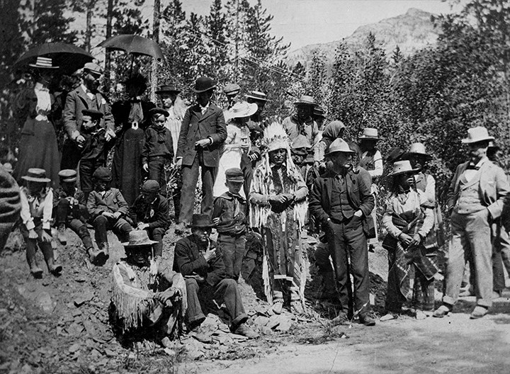
First Banff Indian Days [Chief Hector Crawler (Wachegiye) (Prayer Giver) and Tom Wilson front centre]
https://archives.whyte.org/en/permalink/descriptions50037
- Part Of
- Tom Wilson family fonds
- Scope & Content
- Image of a group of people posed for a photograph - the two men standing in front centre identified as Hector Crawler (Wachegiye) (Prayer Giver) (left) and Tom Wilson (right).
- Date Range
- 1894
- Reference Code
- v701 / 4 / na66 - 488
- Description Level
- 6 / Item
- GMD
- Photograph
- Negative, copy
1 image
- Part Of
- Tom Wilson family fonds
- Description Level
- 6 / Item
- Fonds Number
- V701
- Sous-Fonds
- V701
- Reference Code
- v701 / 4 / na66 - 488
- Date Range
- 1894
- Physical Description
- 1 photograph : negative : copy negative
- Scope & Content
- Image of a group of people posed for a photograph - the two men standing in front centre identified as Hector Crawler (Wachegiye) (Prayer Giver) (left) and Tom Wilson (right).
- Subject Access
- Banff Indian Days
- First nations
- Public events
- Regalia
- Women
- Geographic Access
- Alberta
- British Columbia
- Title Source
- copy negative envelope
- Processing Status
- Processed
Images
This material is presented as originally created; it may contain outdated cultural descriptions and
potentially offensive content.
Read more.