Narrow Results By
- Murray Hay fonds 15
- Ben Gadd fonds 9
- Luxton family fonds 7
- Jim Brewster family fonds 4
- Astley family fonds 2
- Archives General File Collection 1
- Calgary Mountain Club fonds 1
- Jon Whelan fonds 1
- Mary (Molly) Wright Adams fonds 1
- Maryalice Harvey Stewart fonds 1
- Percival R Lockie fonds 1
- William Royle fonds 1
- Part Of
- Ben Gadd fonds
- Scope & Content
- File consists of photographs taken by Ben Gadd during a trip to Jackman Flats Provincial Park in 1997. Images depict unidentified individuals posing next to interpretive signs; hiking trails; a truck driving through sand; and measurements of a geological artifact.
- Date Range
- 1997
- Reference Code
- V810 / III / D / PA - 128 to 172
- Description Level
- 5 / File
- GMD
- Photograph
- Part Of
- Ben Gadd fonds
- Description Level
- 5 / File
- Fonds Number
- M590
- V810
- S61
- Series
- V810 / III : Professional records
- Sous-Fonds
- V810
- Sub-Series
- V810 / III / D : Other contracts and projects
- Accession Number
- 2021.20
- Reference Code
- V810 / III / D / PA - 128 to 172
- GMD
- Photograph
- Responsibility
- Produced by Ben Gadd
- Date Range
- 1997
- Physical Description
- 45 photographs : col. prints ; 10 x 15 cm
- Scope & Content
- File consists of photographs taken by Ben Gadd during a trip to Jackman Flats Provincial Park in 1997. Images depict unidentified individuals posing next to interpretive signs; hiking trails; a truck driving through sand; and measurements of a geological artifact.
- Name Access
- Gadd, Ben
- Subject Access
- Tourism
- Tourist information
- Hiking
- Recreation
- Trails
- Provincial parks and reserves
- Family and personal life
- Geology
- Research
- Geographic Access
- Canada
- British Columbia
- Jackman Flats Provincial Park
- Language
- N/A
- Related Material
- V810/III/D/NA-52 to 53
- Title Source
- Original title used
- Processing Status
- Processed
This material is presented as originally created; it may contain outdated cultural descriptions and
potentially offensive content.
Read more.
Pembina River Provincial Park
https://archives.whyte.org/en/permalink/descriptions56397
- Part Of
- Ben Gadd fonds
- Scope & Content
- File consists of photographs taken by Ben Gadd during a trip to Pembina River Provincial Park, including winter views of hiking trails and forested areas.
- Date Range
- 1997
- Reference Code
- V810 / III / D / PA - 173 to 180
- Description Level
- 5 / File
- GMD
- Photograph
- Part Of
- Ben Gadd fonds
- Description Level
- 5 / File
- Fonds Number
- M590
- V810
- S61
- Series
- V810 / III : Professional records
- Sous-Fonds
- V810
- Sub-Series
- V810 / III / D : Other contracts and projects
- Accession Number
- 2021.20
- Reference Code
- V810 / III / D / PA - 173 to 180
- GMD
- Photograph
- Responsibility
- Produced by Ben Gadd
- Date Range
- 1997
- Physical Description
- 8 photographs : col. prints ; 10 x 15 cm
- Scope & Content
- File consists of photographs taken by Ben Gadd during a trip to Pembina River Provincial Park, including winter views of hiking trails and forested areas.
- Name Access
- Gadd, Ben
- Subject Access
- Tourism
- Tourist information
- Hiking
- Recreation
- Trails
- Provincial parks and reserves
- Geographic Access
- Canada
- British Columbia
- Pembina River Provincial Park
- Language
- N/A
- Category
- Tourism
- Sports, recreation and leisure
- Title Source
- Original title used
- Processing Status
- Processed
This material is presented as originally created; it may contain outdated cultural descriptions and
potentially offensive content.
Read more.
Album, Canadian and American Rocky Mountains
https://archives.whyte.org/en/permalink/descriptions56762
- Part Of
- Mary (Molly) Wright Adams fonds
- Scope & Content
- File consists of one photograph album compiled by Molly Wright Adams containing ca.107 photographs. Images pertain to Molly's travels in the American and Canadian Rocky Mountains in 1904.
- Date Range
- 1904
- Reference Code
- V777 / II / PD - 1
- Description Level
- 5 / File
- GMD
- Album
- Photograph
- Part Of
- Mary (Molly) Wright Adams fonds
- Description Level
- 5 / File
- Fonds Number
- M555
- V777
- Series
- V777 / II : Personal and collected records
- Sous-Fonds
- V777
- Accession Number
- 2018.8685
- Reference Code
- V777 / II / PD - 1
- GMD
- Album
- Photograph
- Responsibility
- Produced by Molly W. Adams
- Date Range
- 1904
- Physical Description
- 1 photo album (ca. 107 photographs : b&w prints)
- Scope & Content
- File consists of one photograph album compiled by Molly Wright Adams containing ca.107 photographs. Images pertain to Molly's travels in the American and Canadian Rocky Mountains in 1904.
- Notes
- Some pages include annotations below photographs
- Name Access
- Adams, Molly
- Subject Access
- Family and personal life
- Mountains
- Landscape
- Travel
- Exploration
- Environment
- Recreation
- Hiking
- Geographic Access
- United States of America
- Rocky Mountains
- Canada
- British Columbia
- Canadian Rocky Mountains
- Access Restrictions
- Materials in file are fragile - handle with caution
- Language
- N/A
- Conservation
- Pages interleaved with acid-free issue paper in 2018
- Title Source
- Title based on contents of file
- Processing Status
- Processed
This material is presented as originally created; it may contain outdated cultural descriptions and
potentially offensive content.
Read more.
Astley family photographs
https://archives.whyte.org/en/permalink/descriptions54238
- Part Of
- Astley family fonds
- Scope & Content
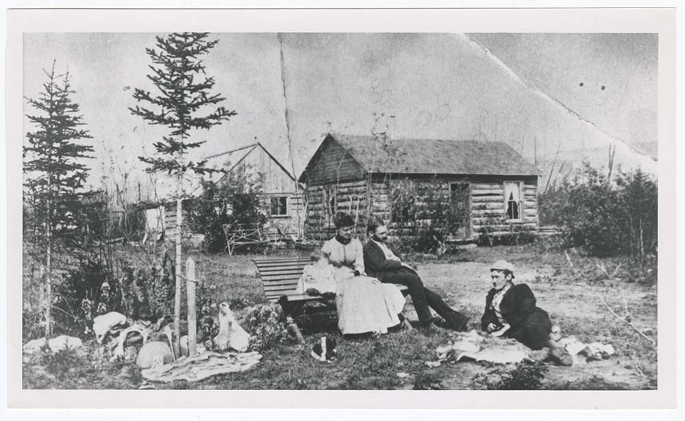
- File consists of 2 b&w prints, some captioned. File pertains to a portrait of Lucy Ann Astley and a group posed in front log cabin, Lake Minnewanka, 1890. File also contains a copy of group photograph at Lake Minnewanka and brief biographical information and obituary of Lucy Ann Andrew.
- Date Range
- [ca.1886]-1970
- Reference Code
- V394 / PA - 42 to 43
- Description Level
- 5 / File
- GMD
- Photograph
- Part Of
- Astley family fonds
- Description Level
- 5 / File
- Fonds Number
- M 265
- V 394
- Sous-Fonds
- V 394
- Accession Number
- 7939
- Reference Code
- V394 / PA - 42 to 43
- GMD
- Photograph
- Date Range
- [ca.1886]-1970
- Physical Description
- Photographs: 2 prints, b&w
- History / Biographical
- See fonds level description
- Scope & Content
- File consists of 2 b&w prints, some captioned. File pertains to a portrait of Lucy Ann Astley and a group posed in front log cabin, Lake Minnewanka, 1890. File also contains a copy of group photograph at Lake Minnewanka and brief biographical information and obituary of Lucy Ann Andrew.
- Name Access
- Astley (family)
- Subject Access
- Buildings and facilities
- Environment
- Family and personal life
- Military
- Sports, recreation and leisure
- Access Restrictions
- Some restriction/s on access
- Copyright, privacy, commercial use and other restrictions may apply
- Language
- Language is English
- Creator
- Astley (family)
- Title Source
- Title based on contents of file
- Processing Status
- Processed
This material is presented as originally created; it may contain outdated cultural descriptions and
potentially offensive content.
Read more.
Astley family photographs
https://archives.whyte.org/en/permalink/descriptions54239
- Part Of
- Astley family fonds
- Scope & Content
- File consists of 42 b&w prints, some captioned. Photographs pertain to fishing and boating on Lake Minnewanka; Beach House Hotel and Lady of the Lake steam launch; Devil's Canyon, Bankhead and Banff; views of avalanche clearing in Roger's Pass by Byron Harmon. Includes one panorama view of group a…
- Date Range
- [ca.1886]-1970
- Reference Code
- V394 / PA - 1 to 42
- Description Level
- 5 / File
- GMD
- Photograph
8 images
- Part Of
- Astley family fonds
- Description Level
- 5 / File
- Fonds Number
- M 265
- V 394
- Sous-Fonds
- V 394
- Accession Number
- 1420
- 6353
- Reference Code
- V394 / PA - 1 to 42
- GMD
- Photograph
- Date Range
- [ca.1886]-1970
- Physical Description
- Photographs: 42 prints, b&w
- History / Biographical
- See fonds level description
- Scope & Content
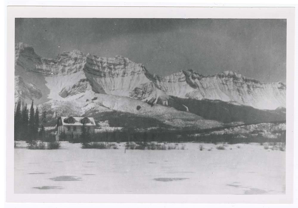
- File consists of 42 b&w prints, some captioned. Photographs pertain to fishing and boating on Lake Minnewanka; Beach House Hotel and Lady of the Lake steam launch; Devil's Canyon, Bankhead and Banff; views of avalanche clearing in Roger's Pass by Byron Harmon. Includes one panorama view of group at Lake Minnewanka.
- Name Access
- Astley (family)
- Subject Access
- Buildings and facilities
- Environment
- Family and personal life
- Military
- Sports, recreation and leisure
- Access Restrictions
- Some restriction/s on access
- Copyright, privacy, commercial use and other restrictions may apply
- Language
- Language is English
- Creator
- Astley (family)
- Title Source
- Title based on contents of file
- Processing Status
- Processed
Images
This material is presented as originally created; it may contain outdated cultural descriptions and
potentially offensive content.
Read more.
Whistler / Blackcomb
https://archives.whyte.org/en/permalink/descriptions54864
- Part Of
- Murray Hay fonds
- Scope & Content
- File consists of 2 maps (1 base, 4 overlays) : col., annotations, on mylar ; 62 x 76 cm and 28 x 32 cm, and 6 prints : b&w and col. ; 42 x 27.5 cm or smaller. File pertains to Murray Hay paintings of maps of Whistler / Blackcomb ski areas. File includes several different iterations reproduced as dr…
- Date Range
- ca.1980-ca.2000
- 1987-1988
- ca.1990
- Reference Code
- V795 / II / A / ii / 1-3
- Description Level
- 5 / File
- GMD
- Map
- Private record
- Part Of
- Murray Hay fonds
- Description Level
- 5 / File
- Fonds Number
- M570 / V795
- Series
- V795 / II : Unpublished Material
- Sous-Fonds
- V795
- Sub-Series
- V795 / II / A : British Columbia / ii : Whistler
- Accession Number
- 2019.41
- Reference Code
- V795 / II / A / ii / 1-3
- GMD
- Map
- Private record
- Date Range
- ca.1980-ca.2000
- 1987-1988
- ca.1990
- Physical Description
- 2 maps (1 base, 4 overlays) : col., annotations, on mylar ; 62 x 76 cm and 28 x 32 cm
- 6 prints : b&w and col. ; 42 x 27.5 cm or smaller
- Scope & Content
- File consists of 2 maps (1 base, 4 overlays) : col., annotations, on mylar ; 62 x 76 cm and 28 x 32 cm, and 6 prints : b&w and col. ; 42 x 27.5 cm or smaller. File pertains to Murray Hay paintings of maps of Whistler / Blackcomb ski areas. File includes several different iterations reproduced as drafting prints, including maps with several mylar overlays (held together with masking tape).
- Notes
- Some prints are annotated in ink. One draft is mounted on a piece of board
- V795 / II / A / ii / 1 is labelled "Horstman Glacier - Blackcomb"
- V795 / II / A / ii / 3 has "Blackcomb Skiing Enterprises, #16815" written on the masking tape. Blackcomb Skiing Enterprises was founded in 1990
- Name Access
- Hay, Murray
- Subject Access
- Artist
- Ski area
- Ski Maps
- Map
- Cartography
- Sports and recreation
- Tourism
- Winter
- Winter sports
- Whistler Blackcomb
- Geographic Access
- Whistler
- British Columbia
- Canada
- Language
- English
- Conservation
- Masking tape and other adhesives are used on some of the items. This should be removed and alternative preservation methods should be considered at a reasonable time to do so.
- Related Material
- M570 / III / A / ii / 1
- Title Source
- Title based on contents of file
- Processing Status
- Processed
This material is presented as originally created; it may contain outdated cultural descriptions and
potentially offensive content.
Read more.
- Part Of
- Murray Hay fonds
- Scope & Content
- File consists of 8 colour prints, 28 x 35 cm or smaller. File pertains to Murray Hay's work for the City of Kimberley, British Columbia. File includes prints of original paintings done by Hay relating to a proposed real estate development in the city and the Kimberley ski hill.
- Date Range
- ca.1979-ca.2000
- Reference Code
- V795 / II / A / iii / 1-2
- Description Level
- 5 / File
- GMD
- Map
- Private record
- Part Of
- Murray Hay fonds
- Description Level
- 5 / File
- Fonds Number
- M570 / V795
- Series
- V795 / II : Unpublished Material
- Sous-Fonds
- V795
- Sub-Series
- V795 / II / A : British Columbia / iii : Kimberley
- Accession Number
- 2019.41
- Reference Code
- V795 / II / A / iii / 1-2
- GMD
- Map
- Private record
- Date Range
- ca.1979-ca.2000
- Physical Description
- 8 prints : col. ; 28 x 35 cm or smaller
- Scope & Content
- File consists of 8 colour prints, 28 x 35 cm or smaller. File pertains to Murray Hay's work for the City of Kimberley, British Columbia. File includes prints of original paintings done by Hay relating to a proposed real estate development in the city and the Kimberley ski hill.
- Notes
- The ski hill at Kimberley was developed in 1979.
- Most of the prints are annotated in ink by Hay (his own notes and comments by clients).
- Name Access
- Hay, Murray
- Subject Access
- Advertising
- Artist
- Art
- Cartography
- Community life
- Landscapes
- Map
- Mountains
- Municipal views
- Ski area
- Ski Maps
- Sports and recreation
- Tourism
- Tourist information
- Winter
- Kimberley Alpine Resort
- Geographic Access
- Kimberley
- British Columbia
- Canada
- Purcell Mountains
- Language
- English
- Conservation
- There is masking tape holding some of the prints together on a piece of paper, which should be removed and alternative preservation methods should be considered at a reasonable time to do so.
- Creator
- Hay, Murray
- Title Source
- Title based on contents of file
- Processing Status
- Processed
This material is presented as originally created; it may contain outdated cultural descriptions and
potentially offensive content.
Read more.
Apex Mountain Ski Resort
https://archives.whyte.org/en/permalink/descriptions54875
- Part Of
- Murray Hay fonds
- Scope & Content
- File consists of 1 map (1 base, 4 overlays) : col., annotations, on mylar ; 83 x 61.5 cm, and 1 print : b&w ; 25.5 x 20.5 cm. File pertains to ski maps Murray Hay created for Apex Mountain Ski Resort in Penticton, British Columbia. File includes one oversize map with four overlays (held together wi…
- Date Range
- ca.1976-ca.2000
- Reference Code
- V795 / II / A / iv / 3-4
- Description Level
- 5 / File
- GMD
- Map
- Private record
- Part Of
- Murray Hay fonds
- Description Level
- 5 / File
- Fonds Number
- M570 / V795
- Series
- V795 / II : Unpublished Material
- Sous-Fonds
- V795
- Sub-Series
- V795 / II / A : British Columbia / iv : Okanagan Area
- Accession Number
- 2019.41
- Reference Code
- V795 / II / A / iv / 3-4
- GMD
- Map
- Private record
- Date Range
- ca.1976-ca.2000
- Physical Description
- 1 map (1 base, 4 overlays) : col., annotations, on mylar ; 83 x 61.5 cm
- 1 print : b&w ; 25.5 x 20.5 cm
- Scope & Content
- File consists of 1 map (1 base, 4 overlays) : col., annotations, on mylar ; 83 x 61.5 cm, and 1 print : b&w ; 25.5 x 20.5 cm. File pertains to ski maps Murray Hay created for Apex Mountain Ski Resort in Penticton, British Columbia. File includes one oversize map with four overlays (held together with masking tape), and one print of the general ski area.
- Notes
- V795 / II / A / iv / 4 : has "16488" and "Hold" written in pencil on the masking tape.
- Name Access
- Hay, Murray
- Subject Access
- Advertising
- Art
- Artist
- Ski Maps
- Map
- Cartography
- Sports and recreation
- Tourism
- Tourist information
- Winter
- Winter sports
- Ski area
- Apex Mountain Ski Resort
- Geographic Access
- British Columbia
- Canada
- Penticton
- Language
- English
- Conservation
- The masking tape should be removed and alternative preservation methods should be considered at a reasonable time to do so.
- Creator
- Hay, Murray
- Title Source
- Title based on contents of file
- Processing Status
- Processed
This material is presented as originally created; it may contain outdated cultural descriptions and
potentially offensive content.
Read more.
Big White Ski Resort
https://archives.whyte.org/en/permalink/descriptions54877
- Part Of
- Murray Hay fonds
- Scope & Content
- File consists of 2 prints : col ; 35 x 28 cm. File pertains to Murray Hay's rendering of the ski area at Big White Ski Resort in Kelowna, British Columbia. File includes two unlabelled, draft print reproductions of original paintings.
- Date Range
- ca.1976-ca.2000
- Reference Code
- V795 / II / A / iv / 5
- Description Level
- 5 / File
- GMD
- Map
- Private record
- Part Of
- Murray Hay fonds
- Description Level
- 5 / File
- Fonds Number
- M570 / V795
- Series
- V795 / II : Unpublished Material
- Sous-Fonds
- V795
- Sub-Series
- V795 / II / A : British Columbia / iv : Okanagan Area
- Accession Number
- 2019.41
- Reference Code
- V795 / II / A / iv / 5
- GMD
- Map
- Private record
- Date Range
- ca.1976-ca.2000
- Physical Description
- 2 prints : col. ; 35 x 28 cm
- Scope & Content
- File consists of 2 prints : col ; 35 x 28 cm. File pertains to Murray Hay's rendering of the ski area at Big White Ski Resort in Kelowna, British Columbia. File includes two unlabelled, draft print reproductions of original paintings.
- Name Access
- Hay, Murray
- Subject Access
- Ski Maps
- Map
- Cartography
- Ski area
- Tourism
- Tourist information
- Winter
- Winter sports
- Sports and recreation
- Big White Ski Area
- Art
- Artist
- Geographic Access
- Kelowna
- British Columbia
- Canada
- Language
- English
- Related Material
- M570 / III / A / v / 1
- Creator
- Hay, Murray
- Category
- Sports, recreation and leisure
- Title Source
- Title based on contents of file
- Processing Status
- Processed
This material is presented as originally created; it may contain outdated cultural descriptions and
potentially offensive content.
Read more.
Fernie Alpine Resort
https://archives.whyte.org/en/permalink/descriptions54883
- Part Of
- Murray Hay fonds
- Scope & Content
- File consists of 2 maps (1 base, 4 overlays) : col., annotations, on mylar ; 32 x 27 cm and 30 x 22 cm, and 2 prints : col. ; 35 x 28 cm. File pertains to Murray Hay's rendering of the ski hill at Fernie, British Columbia. File includes two reproduced drafts with mylar overlays (one held together b…
- Date Range
- ca.1977-ca.1997
- Reference Code
- V795 / II / A / vi / 1-2
- Description Level
- 5 / File
- GMD
- Map
- Private record
- Part Of
- Murray Hay fonds
- Description Level
- 5 / File
- Fonds Number
- M570 / V795
- Series
- V795 / II : Unpublished Material
- Sous-Fonds
- V795
- Sub-Series
- V795 / II / A : British Columbia / vi : Fernie
- Accession Number
- 2019.41
- Reference Code
- V795 / II / A / vi / 1-2
- GMD
- Map
- Private record
- Date Range
- ca.1977-ca.1997
- Physical Description
- 2 maps (1 base, 4 overlays) : col., annotations, on mylar ; 32 x 27 cm and 30 x 22 cm
- 2 prints : col. ; 35 x 28 cm
- Scope & Content
- File consists of 2 maps (1 base, 4 overlays) : col., annotations, on mylar ; 32 x 27 cm and 30 x 22 cm, and 2 prints : col. ; 35 x 28 cm. File pertains to Murray Hay's rendering of the ski hill at Fernie, British Columbia. File includes two reproduced drafts with mylar overlays (one held together by tape or glue, the other by masking tape), and two reproduced draft prints of the ski area.
- Notes
- Date range is approximate. The Timberland sub-division was developed between 1981-1991. The resort was known as Fernie Snow Valley until 1997.
- Name Access
- Hay, Murray
- Subject Access
- Advertising
- Art
- Artist
- Ski Maps
- Cartography
- Sports and recreation
- Tourism
- Tourist information
- Winter
- Winter sports
- Ski area
- Geographic Access
- Fernie
- British Columbia
- Canada
- Canadian Rocky Mountains
- Language
- English
- Conservation
- Masking tape should be removed and alternative preservation methods should be considered at a reasonable time to do so.
- Creator
- Hay, Murray
- Title Source
- Title based on contents of file
- Processing Status
- Processed
This material is presented as originally created; it may contain outdated cultural descriptions and
potentially offensive content.
Read more.
Panorama Mountain Resort & Heli-Ski Area
https://archives.whyte.org/en/permalink/descriptions54884
- Part Of
- Murray Hay fonds
- Scope & Content
- File consists of 3 prints : col. ; 35 x 35 cm and 35 x 28 cm. File pertains to Murray Hay's various renderings of the Panorama ski and heli-ski areas in Invermere, British Columbia. File includes two reproduced draft prints of the Panorama Heli-Ski Area and one reproduced draft print of the Panoram…
- Date Range
- ca.1976-ca.2000
- Reference Code
- V795 / II / A / vii / 1
- Description Level
- 5 / File
- GMD
- Map
- Private record
- Part Of
- Murray Hay fonds
- Description Level
- 5 / File
- Fonds Number
- M570 / V795
- Series
- V795 / II : Unpublished Material
- Sous-Fonds
- V795
- Sub-Series
- V795 / II / A : British Columbia / vii : Invermere
- Accession Number
- 2019.41
- Reference Code
- V795 / II / A / vii / 1
- GMD
- Map
- Private record
- Date Range
- ca.1976-ca.2000
- Physical Description
- 3 prints : col. ; 35 x 35 cm and 35 x 28 cm
- Scope & Content
- File consists of 3 prints : col. ; 35 x 35 cm and 35 x 28 cm. File pertains to Murray Hay's various renderings of the Panorama ski and heli-ski areas in Invermere, British Columbia. File includes two reproduced draft prints of the Panorama Heli-Ski Area and one reproduced draft print of the Panorama Ski Area (each print is labelled in ink).
- Name Access
- Hay, Murray
- Subject Access
- Art
- Artist
- Ski Maps
- Map
- Cartography
- Sports and recreation
- Tourism
- Tourist information
- Helicopter skiing
- Winter
- Winter sports
- Ski area
- Geographic Access
- Panorama
- British Columbia
- Canada
- Invermere
- Language
- English
- Related Material
- M570 / III / A / iii / 1-2
- Creator
- Hay, Murray
- Title Source
- Title based on contents of file
- Processing Status
- Processed
This material is presented as originally created; it may contain outdated cultural descriptions and
potentially offensive content.
Read more.
- Part Of
- Murray Hay fonds
- Scope & Content
- File consists of 5 prints : b&w and col. ; 38 x 26.5 cm or smaller. FIle pertains to Murray Hay's work on different maps for a variety of places in British Columbia, Canada. File includes three draft prints of different iterations of the ski trails at the Fairmont Hot Springs resort; a map labelled…
- Date Range
- ca.1976-ca.2000
- Reference Code
- V795 / II / A / viii / 1-3
- Description Level
- 5 / File
- GMD
- Private record
- Map
- Part Of
- Murray Hay fonds
- Description Level
- 5 / File
- Fonds Number
- M570 / V795
- Series
- V795 / II : Unpublished Material
- Sous-Fonds
- V795
- Sub-Series
- V795 / II / A : British Columbia / viii : Miscellaneous
- Accession Number
- 2019.41
- Reference Code
- V795 / II / A / viii / 1-3
- GMD
- Private record
- Map
- Date Range
- ca.1976-ca.2000
- Physical Description
- 5 prints : b&w and col. ; 38 x 26.5 cm or smaller
- Scope & Content
- File consists of 5 prints : b&w and col. ; 38 x 26.5 cm or smaller. FIle pertains to Murray Hay's work on different maps for a variety of places in British Columbia, Canada. File includes three draft prints of different iterations of the ski trails at the Fairmont Hot Springs resort; a map labelled in pencil (on the back of the print) "Cypress Bowl Cross Country Ski Map - Vancouver", and a map glued or otherwise attached to a piece of white board labelled in blue ink "Blue River Heli Ski Area (approximately the size of Belgium."
- Name Access
- Hay, Murray
- Subject Access
- Advertising
- Artist
- Ski area
- Ski Maps
- Map
- Cartography
- Sports and recreation
- Tourism
- Tourist information
- Helicopter skiing
- Winter
- Winter sports
- Geographic Access
- Vancouver
- Fairmont Hot Springs
- Blue River Resort
- British Columbia
- Canada
- Language
- English
- Conservation
- Adhesives should be removed and alternative preservation methods should be used.
- Related Material
- M570 / III / A / vi / 1
- Creator
- Hay, Murray
- Title Source
- Title based on contents of file
- Processing Status
- Processed
This material is presented as originally created; it may contain outdated cultural descriptions and
potentially offensive content.
Read more.
- Part Of
- Murray Hay fonds
- Scope & Content
- File consists of 2 prints : col. ; 35 x 28 cm. File pertains to Murray Hay's rendering of Marmot Basin ski area in Jasper National Park. File includes two iterations of reproduction draft prints of Hay's map of Marmot Basin.
- Date Range
- ca.1976-ca.2000
- Reference Code
- V795 / II / B / i / 1
- Description Level
- 5 / File
- GMD
- Map
- Private record
- Part Of
- Murray Hay fonds
- Description Level
- 5 / File
- Fonds Number
- M570 / V795
- Series
- V795 / II : Unpublished Material
- Sous-Fonds
- V795
- Sub-Series
- V795 / II / B : Alberta / i : Jasper National Park
- Accession Number
- 2019.41
- Reference Code
- V795 / II / B / i / 1
- GMD
- Map
- Private record
- Date Range
- ca.1976-ca.2000
- Physical Description
- 2 prints : col. ; 35 x 28 cm
- Scope & Content
- File consists of 2 prints : col. ; 35 x 28 cm. File pertains to Murray Hay's rendering of Marmot Basin ski area in Jasper National Park. File includes two iterations of reproduction draft prints of Hay's map of Marmot Basin.
- Name Access
- Hay, Murray
- Subject Access
- Advertising
- Artist
- Ski Maps
- Ski area
- Map
- Cartography
- Sports and recreation
- Tourism
- Tourist information
- Winter
- Winter sports
- Geographic Access
- Jasper Marmot Basin
- Jasper National Park
- Alberta
- Canada
- Canadian Rocky Mountains
- Language
- English
- Related Material
- M570 / III / B / iii / 1
- Creator
- Hay, Murray
- Title Source
- Title based on contents of file
- Processing Status
- Processed
This material is presented as originally created; it may contain outdated cultural descriptions and
potentially offensive content.
Read more.
Lake Louise Area
https://archives.whyte.org/en/permalink/descriptions54925
- Part Of
- Murray Hay fonds
- Scope & Content
- File consists of 6 prints : col. ; 25.5 x 20 cm or smaller. File pertains to Murray Hay's renderings of the Lake Louise ski area. File includes six reproduced draft prints of original paintings of the Lake Louise ski area created by Murray Hay (different iterations).
- Date Range
- ca.1976-ca.2000
- Reference Code
- V795 / II / B / ii / 1
- Description Level
- 5 / File
- GMD
- Map
- Private record
- Part Of
- Murray Hay fonds
- Description Level
- 5 / File
- Fonds Number
- M570 / V795
- Series
- V795 / I : Unpublished Material
- Sous-Fonds
- V795
- Sub-Series
- V795 / I / B : Alberta / ii : Lake Louise
- Accession Number
- 2019.41
- Reference Code
- V795 / II / B / ii / 1
- GMD
- Map
- Private record
- Date Range
- ca.1976-ca.2000
- Physical Description
- 6 prints : col. ; 25.5 x 20 cm or smaller
- Scope & Content
- File consists of 6 prints : col. ; 25.5 x 20 cm or smaller. File pertains to Murray Hay's renderings of the Lake Louise ski area. File includes six reproduced draft prints of original paintings of the Lake Louise ski area created by Murray Hay (different iterations).
- Name Access
- Hay, Murray
- Subject Access
- Advertising
- Artist
- Ski Maps
- Map
- Cartography
- Sports and recreation
- Tourism
- Tourist information
- Winter
- Winter sports
- Ski area
- Lake Louise Ski Area
- Geographic Access
- Lake Louise
- Alberta
- Canada
- Canadian Rocky Mountains
- Language
- English
- Related Material
- M570 / III / B / ii / 1-2
- Creator
- Hay, Murray
- Title Source
- Title based on contents of file
- Processing Status
- Processed
This material is presented as originally created; it may contain outdated cultural descriptions and
potentially offensive content.
Read more.
Grasslands National Park
https://archives.whyte.org/en/permalink/descriptions54970
- Part Of
- Murray Hay fonds
- Scope & Content
- File consists of 3 prints : col. ; 35 x 28 cm and 15 x 10 cm. File pertains to landscape work Murray Hay did for Grasslands National Park in Saskatchewan, Canada. File includes one larger reproduced print of an original painting with two smaller prints taped to the larger one; all depict Grasslands…
- Date Range
- ca. 1976 - ca. 2000
- Reference Code
- V795 / II / C / iv / 1
- Description Level
- 5 / File
- GMD
- Map
- Private record
- Part Of
- Murray Hay fonds
- Description Level
- 5 / File
- Fonds Number
- M570 / V795
- Series
- V795 / II : Unpublished Material
- Sous-Fonds
- V795
- Sub-Series
- V795 / II / C : Canada [general] / iv : Saskatchewan
- Accession Number
- 2019.41
- Reference Code
- V795 / II / C / iv / 1
- GMD
- Map
- Private record
- Date Range
- ca. 1976 - ca. 2000
- Physical Description
- 3 prints : col. ; 35 x 28 cm and 15 x 10 cm
- Scope & Content
- File consists of 3 prints : col. ; 35 x 28 cm and 15 x 10 cm. File pertains to landscape work Murray Hay did for Grasslands National Park in Saskatchewan, Canada. File includes one larger reproduced print of an original painting with two smaller prints taped to the larger one; all depict Grasslands National park.
- Notes
- Originally had a post-it note with the following written on it: "Grasslands National Park - Roughly 25 miles across." This was removed for preservation purposes.
- Some of the prints are held together with masking tape.
- Name Access
- Hay, Murray
- Subject Access
- Advertising
- Artist
- Map
- Cartography
- Tourism
- Landscapes
- Geography
- National parks and reserves
- Tourist information
- Travel
- Geographic Access
- Saskatchewan
- Canada
- Grasslands National Park
- Language
- English
- Conservation
- Masking tape should be removed and alternative preservation methods should be considered at a reasonable time to do so.
- Creator
- Hay, Murray
- Title Source
- Title based on contents of file
- Processing Status
- Processed
This material is presented as originally created; it may contain outdated cultural descriptions and
potentially offensive content.
Read more.
Alts Golf and Ski Resort, Japan
https://archives.whyte.org/en/permalink/descriptions54972
- Part Of
- Murray Hay fonds
- Scope & Content
- File consists of 4 prints : col. ; 22 x 15.5 cm or smaller on sheet 35 x 30 cm. FIle pertains to Murray Hay's work for Alts Golf and Ski Resort in Japan. File includes multiple prints glued/taped to a sheet of paper depicting different areas of the ski area, and is titled "Alts Golf and Ski Resort …
- Date Range
- ca. 1976 - ca. 2000
- Reference Code
- V795 / II / D / ii / 1
- Description Level
- 5 / File
- GMD
- Map
- Private record
- Part Of
- Murray Hay fonds
- Description Level
- 5 / File
- Fonds Number
- M570 / V795
- Series
- V795 / II : Unpublished Material
- Sous-Fonds
- V795
- Sub-Series
- V795 / II / D : International / ii : Miscellaneous
- Accession Number
- 2019.41
- Reference Code
- V795 / II / D / ii / 1
- GMD
- Map
- Private record
- Date Range
- ca. 1976 - ca. 2000
- Physical Description
- 4 prints : col. ; 22 x 15.5 cm or smaller on sheet 35 x 30 cm
- Scope & Content
- File consists of 4 prints : col. ; 22 x 15.5 cm or smaller on sheet 35 x 30 cm. FIle pertains to Murray Hay's work for Alts Golf and Ski Resort in Japan. File includes multiple prints glued/taped to a sheet of paper depicting different areas of the ski area, and is titled "Alts Golf and Ski Resort in the Bandai Area of Japan."
- Name Access
- Hay, Murray
- Subject Access
- Advertising
- Artist
- Ski Maps
- Map
- Cartography
- Sports and recreation
- Tourism
- Tourist information
- Travel
- Winter
- Winter sports
- Ski area
- Geographic Access
- Japan
- Language
- English
- Conservation
- Prints are taped or otherwise glued to the sheet of paper. Adhesives should be removed and alternative preservation methods used at a reasonable time to do so.
- Related Material
- M570 / III / D / ii / 2
- Creator
- Hay, Murray
- Title Source
- Title based on contents of file
- Processing Status
- Processed
This material is presented as originally created; it may contain outdated cultural descriptions and
potentially offensive content.
Read more.
- Part Of
- Murray Hay fonds
- Scope & Content
- File consists of 144 photographs : col. negatives ; 35 m m; 12 prints : col. ; 42 x 35 cm or smaller ; 1 cm of visual material. File pertains to various projects Murray Hay was involved with related to Alaska, USA, particularly in the mid-1990s. File includes: aerial photographs of the landscape (A…
- Date Range
- ca.1990-ca.1999
- 1992
- 1994
- Reference Code
- V795 / II / D / i / 1-2
- Description Level
- 5 / File
- GMD
- Drawing
- Map
- Photograph print
- Negative
- Private record
- Textual record
- Part Of
- Murray Hay fonds
- Description Level
- 5 / File
- Fonds Number
- M570 / V795
- Series
- V795 / II : Unpublished Material
- Sous-Fonds
- V795
- Sub-Series
- V795 / II / D : International / i : United States of America
- Accession Number
- 2019.41
- Reference Code
- V795 / II / D / i / 1-2
- Date Range
- ca.1990-ca.1999
- 1992
- 1994
- Physical Description
- 144 photographs : col. negatives ; 35 mm
- 12 prints : col. ; 42 x 35 cm or smaller
- 1 cm of visual material
- Scope & Content
- File consists of 144 photographs : col. negatives ; 35 m m; 12 prints : col. ; 42 x 35 cm or smaller ; 1 cm of visual material. File pertains to various projects Murray Hay was involved with related to Alaska, USA, particularly in the mid-1990s. File includes: aerial photographs of the landscape (Anchorage area, Homer, Prince William Sound, Valdez); hand-drawn draft maps of the Prince William Sound region (created for a cruise line); a variety of printed maps with annotations demonstrating comments (including a fax with an attached map from Dana at Adventure Media International); and a variety of printed reproductions of draft maps (Alyeska Ski Resort, City of Anchorage for the 1992 Olympic Bid, and Glacier Bay and the Tongass National Forest).
- Notes
- Items not in oversize (negatives) stored in downstairs vault.
- Name Access
- Hay, Murray
- Subject Access
- Advertising
- Artist
- Ski Maps
- Map
- Cartography
- Sports and recreation
- Tourism
- Tourist information
- Travel
- Geography
- Winter
- Winter sports
- Ski area
- Olympic Games (Winter)
- Geographic Access
- Alaska
- United States
- Valdez
- Prince William Sound
- Anchorage
- Glacier Bay and Tongass National Forest
- Language
- English
- Conservation
- Masking tape should be removed and alternative preservation methods used in the future.
- Related Material
- M570 / IV / A / 2-3
- Creator
- Hay, Murray
- Title Source
- Title based on contents of file
- Processing Status
- Processed
This material is presented as originally created; it may contain outdated cultural descriptions and
potentially offensive content.
Read more.
Sunshine Village
https://archives.whyte.org/en/permalink/descriptions54991
- Part Of
- Murray Hay fonds
- Scope & Content
- File consists of 9 prints : b&w and col. ; 35 x 28 cm or smaller, 2 maps (1 base, 4 overlays) : col., annotations, on mylar ; 26 x 35 cm and 23.5 x 31.5 cm, and 1 painting : landscape ; 46 x 43 cm. File pertains to ski trail maps and landscape maps/prints of Sunshine ski area created by Murray Hay.…
- Date Range
- ca.1980-ca.1999
- Reference Code
- V795 / II / B / vi / 1-3
- Description Level
- 5 / File
- GMD
- Map
- Painting
- Private record
- Part Of
- Murray Hay fonds
- Description Level
- 5 / File
- Fonds Number
- M570 / V795
- Series
- V795 / II : Unpublished Material
- Sous-Fonds
- V795
- Sub-Series
- V795 / II / B : Alberta / vi : Sunshine Village Ski Resort
- Accession Number
- 2019.41
- Reference Code
- V795 / II / B / vi / 1-3
- Date Range
- ca.1980-ca.1999
- Physical Description
- 9 prints : b&w and col. ; 35 x 28 cm or smaller
- 2 maps (1 base, 4 overlays) : col., annotations, on mylar ; 26 x 35 cm and 23.5 x 31.5 cm
- 1 painting : landscape ; 46 x 43 cm
- Scope & Content
- File consists of 9 prints : b&w and col. ; 35 x 28 cm or smaller, 2 maps (1 base, 4 overlays) : col., annotations, on mylar ; 26 x 35 cm and 23.5 x 31.5 cm, and 1 painting : landscape ; 46 x 43 cm. File pertains to ski trail maps and landscape maps/prints of Sunshine ski area created by Murray Hay. File includes 9 reproduced draft prints (various iterations), 2 reproduced maps with overlays held together with masking tape, and 1 original painting/drawing (unfinished).
- Name Access
- Hay, Murray
- Subject Access
- Advertising
- Artist
- Ski Maps
- Ski area
- Map
- Cartography
- Sports and recreation
- Tourism
- Tourist information
- Winter
- Winter sports
- Sunshine area
- Sunshine Village
- Sunshine Ski Resort
- Geographic Access
- Sunshine
- Alberta
- Canada
- Canadian Rocky Mountains
- Banff National Park
- Language
- English
- Related Material
- M570 / III / B / i / 1-2
- Creator
- Hay, Murray
- Title Source
- Title based on contents of file
- Processing Status
- Processed
This material is presented as originally created; it may contain outdated cultural descriptions and
potentially offensive content.
Read more.
Banff National Park (general)
https://archives.whyte.org/en/permalink/descriptions55338
- Part Of
- Murray Hay fonds
- Scope & Content
- File consists of 4 prings : col. 35.1 x 24.8 cm or smaller and 4 maps (2 paper, 2 overlays) : col., on mylar ; 60.4 x 30. cm or smaller. File pertains to aerial views of Banff National Park, showing the towns of Banff and Lake Louise, ski hills (Norqay Ski Hill, Sunshine Village, and Lake Louise Sk…
- Date Range
- ca.1976-ca.2000
- Reference Code
- V795 / II / B / v / 1-2
- Description Level
- 5 / File
- GMD
- Map
- Private record
- Part Of
- Murray Hay fonds
- Description Level
- 5 / File
- Fonds Number
- M570 / V795
- Series
- V795 / II : Unpublished Material
- Sous-Fonds
- V795
- Sub-Series
- V795 / II / B : Alberta / v : Banff National Park
- Accession Number
- 2019.41
- Reference Code
- V795 / II / B / v / 1-2
- GMD
- Map
- Private record
- Date Range
- ca.1976-ca.2000
- Physical Description
- 4 prints : col. 35.1 x 24.8 cm or smaller
- 4 maps (2 paper, 2 overlays) : col., annotations, on mylar ; 60.4 x 30. cm or smaller
- Scope & Content
- File consists of 4 prings : col. 35.1 x 24.8 cm or smaller and 4 maps (2 paper, 2 overlays) : col., on mylar ; 60.4 x 30. cm or smaller. File pertains to aerial views of Banff National Park, showing the towns of Banff and Lake Louise, ski hills (Norqay Ski Hill, Sunshine Village, and Lake Louise Ski Resort), as well as other georgraphic features. The mylar overlays contain various amounts of detail and annotations - one consists of a dark red sheet overlayed with place names in negative.
- Notes
- Items not in oversize stored in downstairs vault.
- Name Access
- Hay, Murray
- Subject Access
- Advertising
- Artist
- Ski Maps
- Map
- Cartography
- Sports and recreation
- Tourism
- Tourist information
- Winter
- Winter sports
- Ski area
- Sunshine Village
- Norquay Ski Hill
- Lake Louise Ski Area
- Geographic Access
- Banff
- Lake Louise
- Banff National Park
- Alberta
- Canada
- Canadian Rocky Mountains
- Language
- English
- Creator
- Hay, Murray
- Title Source
- Title based on contents of file
- Processing Status
- Processed
This material is presented as originally created; it may contain outdated cultural descriptions and
potentially offensive content.
Read more.
Kananaskis and Spray Lakes
https://archives.whyte.org/en/permalink/descriptions55339
- Part Of
- Murray Hay fonds
- Scope & Content
- File consists of 2 original paintings : landscape (2 base, 2 overlays) ; 100 x 71.2 cm or smaller (one unfinished) - the complete painting has tracing paper overlay with annotations written in pencil (second overlay also tracing paper with annotations in ink, stored seperately). Also includes 1 map…
- Date Range
- [ca.1980-2000]
- Reference Code
- V795 / II / B / iii / 1
- Description Level
- 5 / File
- GMD
- Map
- Private record
- Part Of
- Murray Hay fonds
- Description Level
- 5 / File
- Fonds Number
- M570 / V795
- Series
- V795 / II : Unpublished Material
- Sous-Fonds
- V795
- Sub-Series
- V795 / II / B : Alberta / iii : Kananaskis
- Accession Number
- 2019.41
- Reference Code
- V795 / II / B / iii / 1
- GMD
- Map
- Private record
- Date Range
- [ca.1980-2000]
- Physical Description
- 2 paintings : landscape (2 base, 2 overlays) ; 100 x 71.2 cm or smaller
- 1 map (1 base, 1 overlay) : col., annotations, on mylar ; 101 x 70.1 cm
- 2 prints : col., annotations ; 35.5 x 27.8 cm
- Scope & Content
- File consists of 2 original paintings : landscape (2 base, 2 overlays) ; 100 x 71.2 cm or smaller (one unfinished) - the complete painting has tracing paper overlay with annotations written in pencil (second overlay also tracing paper with annotations in ink, stored seperately). Also includes 1 map (1 base, 1 overlay) : col., annotations, on mylar ; 101 x 70.1 cm of the Kananaskis/Canmore area and 2 prints : col., annotations ; 35.5 x 27.8 cm of the same area.
- Notes
- Prints have two different titles associated with them: "Portion of Kananaskis, Bow Valley, Spray Lake Area (cloudy portion is for story area)" and "Kanasakis Park, Mount Allen (Nakiska) Ski Area, Fortress Mtn Ski Area & Banff East Entrance (cloudy area for story line)." Prints are connected to the map.
- Name Access
- Hay, Murray
- Subject Access
- Artist
- Ski Maps
- Map
- Cartography
- Sports and recreation
- Tourism
- Winter
- Winter sports
- Geographic Access
- Banff National Park
- Alberta
- Canada
- Spray Lakes
- Spray Valley
- Bow Valley
- Kananaskis
- Canmore
- Language
- English
- Conservation
- Masking tape should be removed
- Creator
- Hay, Murray
- Title Source
- Title based on contents of file
- Processing Status
- Processed
This material is presented as originally created; it may contain outdated cultural descriptions and
potentially offensive content.
Read more.