Narrow Results By
- Bruno Engler fonds 134
- Peter and Catharine Whyte fonds 49
- Luxton family fonds 28
- Murray Hay fonds 21
- Nicholas Morant fonds 19
- Ben Gadd fonds 13
- Arthur A. Goodsell fonds 6
- Alpine Club of Canada fonds 5
- James Irving McLeod fonds 5
- Jim Brewster family fonds 4
- William Royle fonds 4
- Maryalice Harvey Stewart fonds 3
Banff land use bylaw
https://archives.whyte.org/en/permalink/catalogue23276
- Medium
- Library - Maps and blueprints (unannotated; published)
- Map
- Published Date
- November 13, 1989
- Call Number
- C4-1.19
- Responsibility
- sgd. Barlow et al.
- Published Date
- November 13, 1989
- Physical Description
- 1 map
- Scale
- Scale: 1 : 5,000
- Subjects
- Banff townsite
- Call Number
- C4-1.19
- Collection
- Archives Library
This material is presented as originally created; it may contain outdated cultural descriptions and
potentially offensive content.
Read more.
Kinuseo Creek, Peace River Land District, British Columbia
https://archives.whyte.org/en/permalink/catalogue23702
- Medium
- Library - Maps and blueprints (unannotated; published)
- Map
- Published Date
- 1989
- Publisher
- Ottawa : Canada Centre for Mapping
- Edition
- 3d ed.
- Call Number
- NTS
- 931/15
- Edition
- 3d ed.
- Publisher
- Ottawa : Canada Centre for Mapping
- Published Date
- 1989
- Physical Description
- 1 map : col
- Scale
- Scale: 1:50,000
- Subjects
- Kinuseo Creek
- British Columbia
- Accession Number
- 22,500
- Call Number
- NTS
- 931/15
- Collection
- Archives Library
This material is presented as originally created; it may contain outdated cultural descriptions and
potentially offensive content.
Read more.
Tumbler Ridge, Peace River Land District, British Columbia
https://archives.whyte.org/en/permalink/catalogue23928
- Medium
- Library - Maps and blueprints (unannotated; published)
- Map
- Published Date
- 1989
- Publisher
- Ottawa : Canada Centre for Mapping
- Edition
- 3d ed.
- Call Number
- NTS
- 93P/2
- Edition
- 3d ed.
- Publisher
- Ottawa : Canada Centre for Mapping
- Published Date
- 1989
- Physical Description
- 1 map : col
- Scale
- 1:50,000
- Subjects
- Tumbler Ridge (B.C.)
- Accession Number
- 22,500
- Call Number
- NTS
- 93P/2
- Collection
- Archives Library
This material is presented as originally created; it may contain outdated cultural descriptions and
potentially offensive content.
Read more.
Monkman Pass, British Columbia
https://archives.whyte.org/en/permalink/catalogue24097
- Medium
- Library - Maps and blueprints (unannotated; published)
- Map
- Published Date
- 1989
- Publisher
- Ottawa : Canada Centre for Mapping
- Edition
- 2d ed.
- Call Number
- NTS
- 93I
- Edition
- 2d ed.
- Publisher
- Ottawa : Canada Centre for Mapping
- Published Date
- 1989
- Physical Description
- 1 map : col
- Scale
- Scale: 1:250,000
- Subjects
- Monkman Pass
- British Columbia
- Accession Number
- 22,500
- Call Number
- NTS
- 93I
- Collection
- Archives Library
This material is presented as originally created; it may contain outdated cultural descriptions and
potentially offensive content.
Read more.
The Hinton Trail [map]
https://archives.whyte.org/en/permalink/catalogue24305
- Medium
- Library - Maps and blueprints (unannotated; published)
- Map
- Published Date
- 1989
- Author
- Guest, Robert
- Publisher
- [Beaverlodge] : R. Guest
- Call Number
- C6-3.11
- Author
- Guest, Robert
- Publisher
- [Beaverlodge] : R. Guest
- Published Date
- 1989
- Physical Description
- 1 map
- Scale
- 1 inch = 8 miles
- Subjects
- Hinton Trail
- Guest, Robert
- Notes
- Beaverlodge
- Map to be used with book by R. Guest: anticipated publication date (as of 1989), 1992
- Accession Number
- 5711
- Call Number
- C6-3.11
- Collection
- Archives Library
This material is presented as originally created; it may contain outdated cultural descriptions and
potentially offensive content.
Read more.
Lake Louise [townsite]
https://archives.whyte.org/en/permalink/catalogue23281
- Medium
- Library - Maps and blueprints (unannotated; published)
- Map
- Published Date
- 1989
- Publisher
- Calgary: Parks Canada Western Region?
- Call Number
- C4-2.2a
- Publisher
- Calgary: Parks Canada Western Region?
- Published Date
- 1989
- Physical Description
- 1 map : col
- Scale
- Scale indeterminable
- Subjects
- Lake Louise Visitors Centre
- Call Number
- C4-2.2a
- Collection
- Archives Library
This material is presented as originally created; it may contain outdated cultural descriptions and
potentially offensive content.
Read more.
The Hinton Trail [map]
https://archives.whyte.org/en/permalink/catalogue23372
- Medium
- Library - Maps and blueprints (unannotated; published)
- Map
- Published Date
- 1989
- Author
- Guest, Robert
- Publisher
- [Beaverlodge] : R. Guest
- Call Number
- C6-3.11
- Author
- Guest, Robert
- Publisher
- [Beaverlodge] : R. Guest
- Published Date
- 1989
- Physical Description
- 1 map
- Scale
- 1 inch = 8 miles
- Subjects
- Hinton Trail
- Guest, Robert
- Notes
- Beaverlodge
- Map to be used with book by R. Guest: anticipated publication date (as of 1989), 1992
- Accession Number
- 5711
- Call Number
- C6-3.11
- Collection
- Archives Library
This material is presented as originally created; it may contain outdated cultural descriptions and
potentially offensive content.
Read more.
- Part Of
- Ben Gadd fonds
- Scope & Content
- File consists of two photographs taken by Ben Gadd in 1989, depicting "no trespassing signs" placed near Luscar Mine, east of Jasper National Park.
- Date Range
- 1989
- Reference Code
- V810 / I / C / PA - 76 to 77
- Description Level
- 5 / File
- GMD
- Photograph
- Part Of
- Ben Gadd fonds
- Description Level
- 5 / File
- Fonds Number
- M590
- V810
- S61
- Series
- V810 / I : Personal records
- Sous-Fonds
- V810
- Sub-Series
- V810 / I / C : Personal interest files
- Accession Number
- 2021.20
- Reference Code
- V810 / I / C / PA - 76 to 77
- GMD
- Photograph
- Responsibility
- Produced by Ben Gadd
- Date Range
- 1989
- Physical Description
- 2 photographs : col. prints ; 15 x 10 cm
- Scope & Content
- File consists of two photographs taken by Ben Gadd in 1989, depicting "no trespassing signs" placed near Luscar Mine, east of Jasper National Park.
- Notes
- Photographs in file are annotated by Ben Gadd
- Name Access
- Gadd, Ben
- Subject Access
- Natural resources
- Mining
- Mines and mineral resources
- Geographic Access
- Canada
- Alberta
- Luscar
- Language
- English
- Related Material
- M590 / I / C / 103
- Category
- Natural resources
- Title Source
- Title based on contents of file
- Processing Status
- Processed
This material is presented as originally created; it may contain outdated cultural descriptions and
potentially offensive content.
Read more.
Edson, Yellowhead Improvement District, Alberta
https://archives.whyte.org/en/permalink/catalogue23600
- Medium
- Library - Maps and blueprints (unannotated; published)
- Map
- Published Date
- 1988
- Publisher
- Ottawa : Canada Centre for Mapping
- Edition
- 3d ed.
- Call Number
- NTS
- 83F/9
- Edition
- 3d ed.
- Publisher
- Ottawa : Canada Centre for Mapping
- Published Date
- 1988
- Physical Description
- 1 map : col
- Scale
- Scale: 1:50,000
- Accession Number
- 26,500
- Call Number
- NTS
- 83F/9
- Collection
- Archives Library
This material is presented as originally created; it may contain outdated cultural descriptions and
potentially offensive content.
Read more.
Edson, Alberta
https://archives.whyte.org/en/permalink/catalogue24045
- Medium
- Library - Maps and blueprints (unannotated; published)
- Map
- Published Date
- 1988
- Publisher
- Ottawa : Surveys and Mapping Branch, Dept. of Energy, Mines and Resources
- Edition
- 2d ed.
- Call Number
- NTS
- 83F
- Edition
- 2d ed.
- Publisher
- Ottawa : Surveys and Mapping Branch, Dept. of Energy, Mines and Resources
- Published Date
- 1988
- Physical Description
- 1 map : col
- Scale
- 1:250,000
- Subjects
- Edson region
- Accession Number
- 26,500
- Call Number
- NTS
- 83F
- Collection
- Archives Library
This material is presented as originally created; it may contain outdated cultural descriptions and
potentially offensive content.
Read more.
Mount Robson : Alberta - British Columbia
https://archives.whyte.org/en/permalink/catalogue24104
- Medium
- Library - Maps and blueprints (unannotated; published)
- Map
- Published Date
- 1988
- Publisher
- Ottawa : Surveys and Mapping Branch, Dept. of Energy, Mines and Resources
- Edition
- 2d ed.
- Call Number
- NTS
- 83E
- Edition
- 2d ed.
- Publisher
- Ottawa : Surveys and Mapping Branch, Dept. of Energy, Mines and Resources
- Published Date
- 1988
- Physical Description
- 1 map : col
- Scale
- Scale: 1:250,000
- Subjects
- Mount Robson
- Alberta/British Columbia
- Accession Number
- 26,500
- Call Number
- NTS
- 83E
- Collection
- Archives Library
This material is presented as originally created; it may contain outdated cultural descriptions and
potentially offensive content.
Read more.
Mount Robson : Alberta-British Columbia
https://archives.whyte.org/en/permalink/catalogue24105
- Medium
- Library - Maps and blueprints (unannotated; published)
- Map
- Published Date
- 1988
- Publisher
- Ottawa : Surveys and Mapping Branch, Dept. of Energy, Mines and Resources
- Edition
- 2d ed.
- Call Number
- NTS
- 83E
- Edition
- 2d ed.
- Publisher
- Ottawa : Surveys and Mapping Branch, Dept. of Energy, Mines and Resources
- Published Date
- 1988
- Scale
- Scale: 1:250,000
- Subjects
- Mount Robson
- Alberta/British Columbia
- Accession Number
- 26,500
- Call Number
- NTS
- 83E
- Collection
- Archives Library
This material is presented as originally created; it may contain outdated cultural descriptions and
potentially offensive content.
Read more.
Wapiti, Alberta
https://archives.whyte.org/en/permalink/catalogue24168
- Medium
- Library - Maps and blueprints (unannotated; published)
- Map
- Published Date
- 1988
- Publisher
- Ottawa : Surveys and Mapping Branch, Dept. of Energy, Mines and Resources
- Edition
- 2d ed.
- Call Number
- NTS
- 83L
- Edition
- 2d ed.
- Publisher
- Ottawa : Surveys and Mapping Branch, Dept. of Energy, Mines and Resources
- Published Date
- 1988
- Physical Description
- 1 map : col
- Scale
- Scale: 1:250,000
- Accession Number
- 27,000
- Call Number
- NTS
- 83L
- Collection
- Archives Library
This material is presented as originally created; it may contain outdated cultural descriptions and
potentially offensive content.
Read more.
St. John's recreational picture map
https://archives.whyte.org/en/permalink/catalogue24319
- Medium
- Library - Maps and blueprints (unannotated; published)
- Map
- Published Date
- 1988
- Publisher
- Olds : P.R. St. John
- Call Number
- C6-4.3j
- Publisher
- Olds : P.R. St. John
- Published Date
- 1988
- Physical Description
- 1 map : col
- Scale
- indeterminable
- Subjects
- Banff region
- St. John, Patrick R.
- Notes
- Banff and vicinity.../Patrick R. St. John
- Call Number
- C6-4.3j
- Collection
- Archives Library
This material is presented as originally created; it may contain outdated cultural descriptions and
potentially offensive content.
Read more.
Canada : native peoples, 1630
https://archives.whyte.org/en/permalink/catalogue24352
- Medium
- Library - Maps and blueprints (unannotated; published)
- Map
- Published Date
- 1988
- Publisher
- Ottawa : Canada Map Office
- Edition
- 5th ed.
- Call Number
- C6-6.5a
- Edition
- 5th ed.
- Publisher
- Ottawa : Canada Map Office
- Published Date
- 1988
- Physical Description
- 1 map : col
- Scale
- 1:7,500,000
- Series
- National Atlas of Canada
- Subjects
- Archaeology
- Indians
- Notes
- produced by the Geographical Services Division, Canada Centre for Mapping
- Call Number
- C6-6.5a
- Collection
- Archives Library
This material is presented as originally created; it may contain outdated cultural descriptions and
potentially offensive content.
Read more.
St. John's recreational picture map
https://archives.whyte.org/en/permalink/catalogue23386
- Medium
- Library - Maps and blueprints (unannotated; published)
- Map
- Published Date
- 1988
- Publisher
- Olds : P.R. St. John
- Call Number
- C6-4.3j
- Publisher
- Olds : P.R. St. John
- Published Date
- 1988
- Physical Description
- 1 map : col
- Scale
- indeterminable
- Subjects
- Banff region
- St. John, Patrick R.
- Notes
- Banff and vicinity.../Patrick R. St. John
- Call Number
- C6-4.3j
- Collection
- Archives Library
This material is presented as originally created; it may contain outdated cultural descriptions and
potentially offensive content.
Read more.
Canada : native peoples, 1630
https://archives.whyte.org/en/permalink/catalogue23419
- Medium
- Library - Maps and blueprints (unannotated; published)
- Map
- Published Date
- 1988
- Publisher
- Ottawa : Canada Map Office
- Edition
- 5th ed.
- Call Number
- C6-6.5a
- Edition
- 5th ed.
- Publisher
- Ottawa : Canada Map Office
- Published Date
- 1988
- Physical Description
- 1 map : col
- Scale
- 1:7,500,000
- Series
- National Atlas of Canada
- Subjects
- Archaeology
- Indians
- Notes
- produced by the Geographical Services Division, Canada Centre for Mapping
- Call Number
- C6-6.5a
- Collection
- Archives Library
This material is presented as originally created; it may contain outdated cultural descriptions and
potentially offensive content.
Read more.
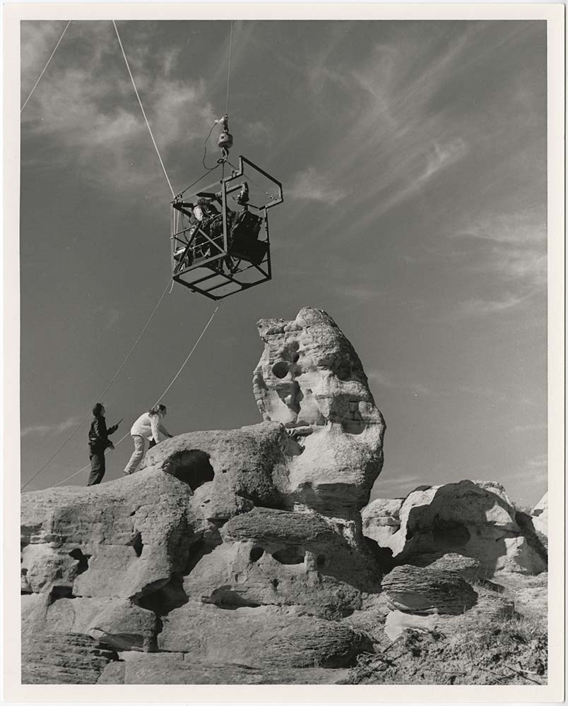
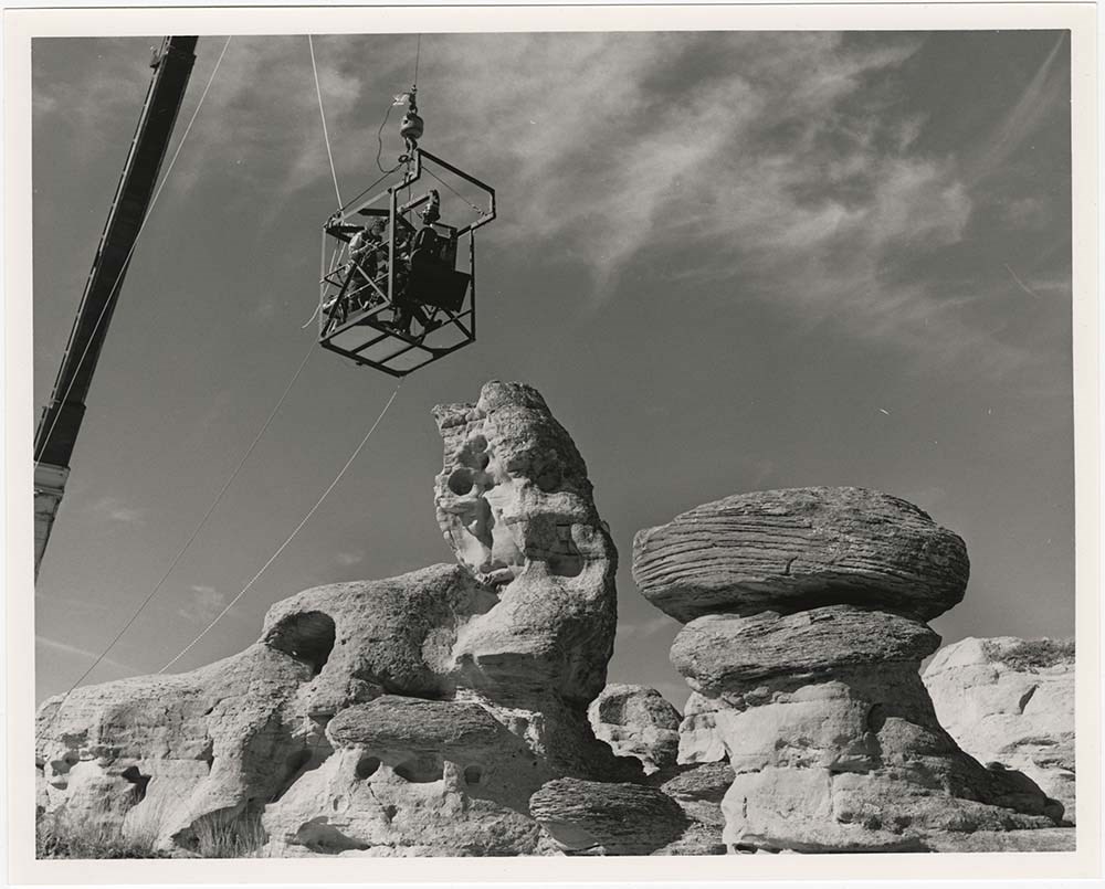
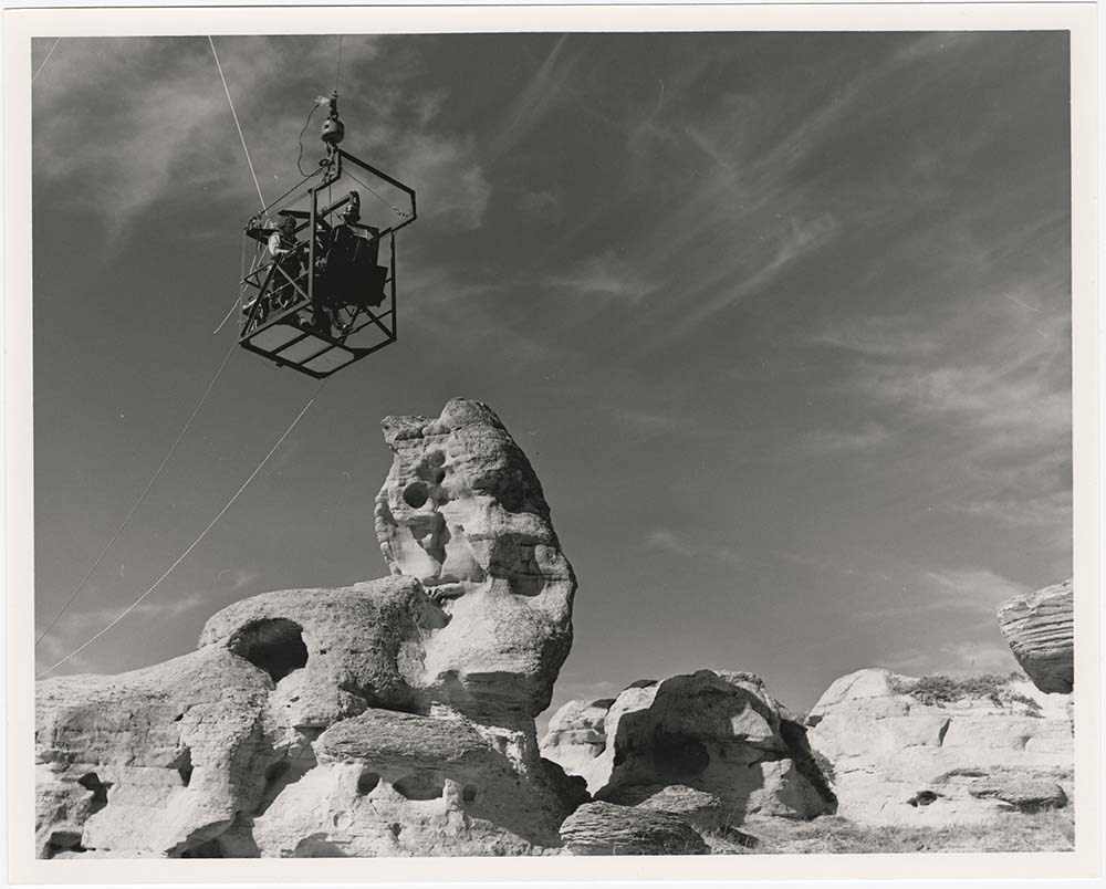
Milk River, Alberta
https://archives.whyte.org/en/permalink/descriptions57193
- Part Of
- Bruno Engler fonds
- Scope & Content
- File pertains to 6 b&w prints of filming an IMAX movie being filmed around the Milk River, Alberta area. Includes shots of hoodoos, a bald eagle and its handler, and the production equipment.
- Date Range
- 1988
- Reference Code
- V190 / VI / M / i / PA - 01 to PA - 06
- Description Level
- 5 / File
- GMD
- Photograph
6 images
- Part Of
- Bruno Engler fonds
- Description Level
- 5 / File
- Fonds Number
- M323 / S40 / V190
- Series
- VI : Retained file, M : Alphabetical order
- Sous-Fonds
- V190
- Sub-Series
- i : Milk River
- Accession Number
- 7436
- Reference Code
- V190 / VI / M / i / PA - 01 to PA - 06
- GMD
- Photograph
- Date Range
- 1988
- Physical Description
- 6 photographs : b&w ; 25.2 x 20.2 cm
- History / Biographical
- See fonds level description
- Scope & Content
- File pertains to 6 b&w prints of filming an IMAX movie being filmed around the Milk River, Alberta area. Includes shots of hoodoos, a bald eagle and its handler, and the production equipment.
- Subject Access
- Bald Eagle
- Birds
- Films and film making
- Hoodoos
- Geographic Access
- Milk River
- Alberta
- Language
- English
- Creator
- Engler, Bruno
- Title Source
- Original title kept
- Processing Status
- Processed
Images


This material is presented as originally created; it may contain outdated cultural descriptions and
potentially offensive content.
Read more.
Calgary/Banff from space
https://archives.whyte.org/en/permalink/catalogue21511
- Medium
- Library - Maps and blueprints (unannotated; published)
- Map
- Published Date
- 1987
- Publisher
- Vancouver : Advanced Satellite Productions
- Call Number
- C12-4.25
- Publisher
- Vancouver : Advanced Satellite Productions
- Published Date
- 1987
- Physical Description
- 1 satellite photo : col
- Subjects
- Calgary
- Banff
- Aerial Photography
- Accession Number
- 21,000
- Call Number
- C12-4.25
- Collection
- Archives Library
This material is presented as originally created; it may contain outdated cultural descriptions and
potentially offensive content.
Read more.
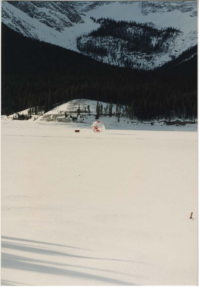
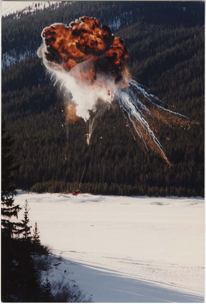
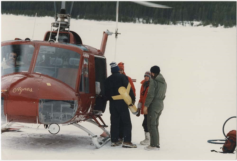
Movie: Peugeot Car Commercial
https://archives.whyte.org/en/permalink/descriptions57256
- Part Of
- Bruno Engler fonds
- Scope & Content
- File pertains to 41 colour prints of production photos from the filming of a Peugeot car commercial on Spray Lakes. Includes shots of the crew and director, action shots of the car driving on the lake and being dropped with a parachute from a helicopter, and an explosion.
- Date Range
- 1987
- Reference Code
- V190 / VI / M / x / r / PA - 01 to PA - 41
- Description Level
- 5 / File
- GMD
- Photograph
7 images
- Part Of
- Bruno Engler fonds
- Description Level
- 5 / File
- Fonds Number
- M323 / S40 / V190
- Series
- VI : Retained file, M : Alphabetical order
- Sous-Fonds
- V190
- Sub-Series
- x : Movies, r : Peugeot Car Commercial
- Accession Number
- 7436
- Reference Code
- V190 / VI / M / x / r / PA - 01 to PA - 41
- GMD
- Photograph
- Date Range
- 1987
- Physical Description
- 41 photographs : col. ; 14.9 x 10.1 cm
- Scope & Content
- File pertains to 41 colour prints of production photos from the filming of a Peugeot car commercial on Spray Lakes. Includes shots of the crew and director, action shots of the car driving on the lake and being dropped with a parachute from a helicopter, and an explosion.
- Subject Access
- Automobiles
- Films and film making
- Helicopters
- Winter
- Geographic Access
- Spray Lakes
- Kananaskis Country
- Alberta
- Language
- English
- Related Material
- V190 / VI / M / x / r / NA - 01 to NA - 20
- Creator
- Engler, Bruno
- Title Source
- Original title kept
- Processing Status
- Processed
Images


This material is presented as originally created; it may contain outdated cultural descriptions and
potentially offensive content.
Read more.