Narrow Results By
- Murray Hay fonds 20
- Luxton family fonds 12
- Nicholas Morant fonds 12
- Ben Gadd fonds 11
- Alpine Club of Canada fonds 3
- Maryalice Harvey Stewart fonds 3
- Archives General File Collection 2
- William Royle fonds 2
- Bob Smith fonds 1
- Calgary Mountain Club fonds 1
- Canadian Pacific Railway fonds 1
- Jim Brewster family fonds 1
- Part Of
- Ben Gadd fonds
- Scope & Content
- File consists of two photographs taken by Ben Gadd in 1989, depicting "no trespassing signs" placed near Luscar Mine, east of Jasper National Park.
- Date Range
- 1989
- Reference Code
- V810 / I / C / PA - 76 to 77
- Description Level
- 5 / File
- GMD
- Photograph
- Part Of
- Ben Gadd fonds
- Description Level
- 5 / File
- Fonds Number
- M590
- V810
- S61
- Series
- V810 / I : Personal records
- Sous-Fonds
- V810
- Sub-Series
- V810 / I / C : Personal interest files
- Accession Number
- 2021.20
- Reference Code
- V810 / I / C / PA - 76 to 77
- GMD
- Photograph
- Responsibility
- Produced by Ben Gadd
- Date Range
- 1989
- Physical Description
- 2 photographs : col. prints ; 15 x 10 cm
- Scope & Content
- File consists of two photographs taken by Ben Gadd in 1989, depicting "no trespassing signs" placed near Luscar Mine, east of Jasper National Park.
- Notes
- Photographs in file are annotated by Ben Gadd
- Name Access
- Gadd, Ben
- Subject Access
- Natural resources
- Mining
- Mines and mineral resources
- Geographic Access
- Canada
- Alberta
- Luscar
- Language
- English
- Related Material
- M590 / I / C / 103
- Category
- Natural resources
- Title Source
- Title based on contents of file
- Processing Status
- Processed
This material is presented as originally created; it may contain outdated cultural descriptions and
potentially offensive content.
Read more.
- Part Of
- Luxton family fonds
- Scope & Content
- File consists of one colour photograph depicting a view of Bow Lake, taken in October 1983.
- Date Range
- 1983
- Reference Code
- LUX / III / A3c / PA - 1
- Description Level
- 5 / File
- GMD
- Photograph
- Part Of
- Luxton family fonds
- Description Level
- 5 / File
- Fonds Number
- LUX
- Series
- LUX / III / A : Norman Luxton family
- Sous-Fonds
- LUX / III : Luxton family sous-fonds
- Sub-Series
- LUX / III / A3 : Collected material
- Accession Number
- LUX
- Reference Code
- LUX / III / A3c / PA - 1
- GMD
- Photograph
- Date Range
- 1983
- Physical Description
- 1 photograph : col. print ; 10 x 10 cm
- Scope & Content
- File consists of one colour photograph depicting a view of Bow Lake, taken in October 1983.
- Notes
- Photograph is annotated on back: "Bow Lakes Oct. /83"
- Subject Access
- Environment
- Landscapes
- Mountains
- Geographic Access
- Canada
- Alberta
- Banff National Park
- Bow Lake
- Language
- English
- Conservation
- Item stored in mylar
- Category
- Environment
- Title Source
- Title based on contents of file
- Processing Status
- Processed
This material is presented as originally created; it may contain outdated cultural descriptions and
potentially offensive content.
Read more.
Snaring Karst project
https://archives.whyte.org/en/permalink/descriptions56080
- Part Of
- Ben Gadd fonds
- Scope & Content
- File consists of 22 photograph prints depicting researchers and geological surveys near Snaring Karst in 1982. Photographs pertain to a report about the Snaring Karst produced by Ben Gadd in 1983, on behalf of Parks Canada.
- Date Range
- 1982
- Reference Code
- V810 / III / A / PA - 1 to 11
- Description Level
- 5 / File
- GMD
- Photograph
- Part Of
- Ben Gadd fonds
- Description Level
- 5 / File
- Fonds Number
- M590
- V810
- S61
- Series
- V810 / III : Professional records
- Sous-Fonds
- V810
- Sub-Series
- V810 / III / A : Parks Canada records
- Accession Number
- 2021.20
- Reference Code
- V810 / III / A / PA - 1 to 11
- GMD
- Photograph
- Responsibility
- Produced by Department of Environment, Government of Canada
- Date Range
- 1982
- Physical Description
- 22 photographs : col. prints ; 9 x 12.5 cm
- Scope & Content
- File consists of 22 photograph prints depicting researchers and geological surveys near Snaring Karst in 1982. Photographs pertain to a report about the Snaring Karst produced by Ben Gadd in 1983, on behalf of Parks Canada.
- Notes
- File contains one duplicate of each image
- Name Access
- Gadd, Ben
- Subject Access
- Geology
- Caves
- Surveying
- Research
- Government
- Environment
- Geographic Access
- Canada
- Alberta
- Jasper National Park
- Reproduction Restrictions
- Restrictions may apply
- Language
- N/A
- Related Material
- V810 / III / A / NA - 1 to 3
- M590 / III / A / 18 to 20
- Category
- Environment
- Government
- Title Source
- Title based on contents of file
- Processing Status
- Processed
This material is presented as originally created; it may contain outdated cultural descriptions and
potentially offensive content.
Read more.
Snaring Karst project
https://archives.whyte.org/en/permalink/descriptions56081
- Part Of
- Ben Gadd fonds
- Scope & Content
- File consists of 3 negative film strips containing 12 colour images. Photographs pertain to geological research completed in 1982 at Snaring Karst in Jasper National Park. Ben Gadd produced a report pertaining to Snaring Karst in 1983 as part of his role as a Seasonal Naturalist for Parks Canada.
- Date Range
- 1982
- Reference Code
- V810 / III / A / NA - 1 to 3
- Description Level
- 5 / File
- GMD
- Photograph
- Part Of
- Ben Gadd fonds
- Description Level
- 5 / File
- Fonds Number
- M590
- V810
- S61
- Series
- V810 / III : Professional records
- Sous-Fonds
- V810
- Sub-Series
- V810 / III / A : Parks Canada records
- Accession Number
- 2021.20
- Reference Code
- V810 / III / A / NA - 1 to 3
- GMD
- Photograph
- Responsibility
- Produced by Department of Environment, Government of Canada
- Date Range
- 1982
- Physical Description
- 12 photographs : col. negatives ; 35 mm
- Scope & Content
- File consists of 3 negative film strips containing 12 colour images. Photographs pertain to geological research completed in 1982 at Snaring Karst in Jasper National Park. Ben Gadd produced a report pertaining to Snaring Karst in 1983 as part of his role as a Seasonal Naturalist for Parks Canada.
- Name Access
- Gadd, Ben
- Subject Access
- Geology
- Caves
- Surveying
- Research
- Government
- Environment
- Geographic Access
- Canada
- Alberta
- Jasper National Park
- Reproduction Restrictions
- Restrictions may apply
- Language
- N/A
- Related Material
- V810 / III / A / PA - 1 to 11
- M590 / III / A / 18 to 20
- Category
- Environment
- Government
- Title Source
- Title based on contents of file
- Processing Status
- Processed
This material is presented as originally created; it may contain outdated cultural descriptions and
potentially offensive content.
Read more.
Brewster house
https://archives.whyte.org/en/permalink/descriptions55681
- Part Of
- Maryalice Harvey Stewart fonds
- Scope & Content
- File consists of 14 photographs depicting interior and exterior views of the Brewster family residence in Banff, ca. 1981.
- Date Range
- 1981
- Reference Code
- V605 / I / B / PA - 1 to 14
- Description Level
- 5 / File
- GMD
- Photograph
- Part Of
- Maryalice Harvey Stewart fonds
- Description Level
- 5 / File
- Fonds Number
- M9
- S13
- V605
- Series
- V605 / I : Professional records
- Sous-Fonds
- V605
- Sub-Series
- V605 / I / B : Research and other professional records
- Accession Number
- 1300
- 7412
- Reference Code
- V605 / I / B / PA - 1 to 14
- GMD
- Photograph
- Date Range
- 1981
- Physical Description
- 14 photographs : b&w and col. prints ; 25 x 20 cm and 8.5 x 8.5 cm
- Scope & Content
- File consists of 14 photographs depicting interior and exterior views of the Brewster family residence in Banff, ca. 1981.
- Notes
- Original envelope stored in file, annotated on back: "Brewster House Fall 1981???"
- Geographic Access
- Canada
- Alberta
- Banff
- Reproduction Restrictions
- Copyright status unknown
- Language
- English
- Related Material
- M9 / I / B / 10
- Title Source
- Original title from storage envelope used
- Processing Status
- Processed
This material is presented as originally created; it may contain outdated cultural descriptions and
potentially offensive content.
Read more.
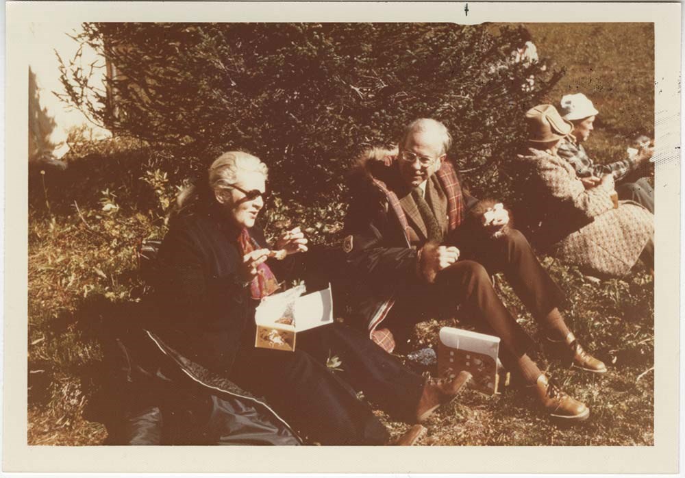
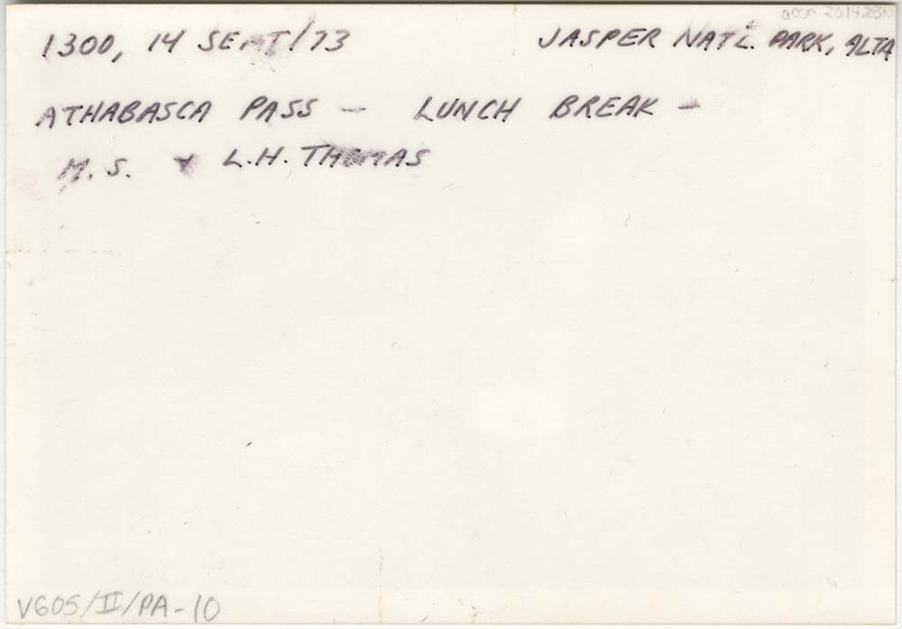
Athabasca Pass trip
https://archives.whyte.org/en/permalink/descriptions55684
- Part Of
- Maryalice Harvey Stewart fonds
- Scope & Content
- File consists of 10 photographs depicting Maryalice Harvey Stewart and friends during a trip to Athabasca Pass in Jasper National Park to celebrate the unveiling of a historic site plaque.
- Date Range
- 1973
- Reference Code
- V605 / II / PA - 1 to 10
- Description Level
- 5 / File
- GMD
- Photograph
2 images
- Part Of
- Maryalice Harvey Stewart fonds
- Description Level
- 5 / File
- Fonds Number
- M9
- S13
- V605
- Series
- V605 / II: Personal records
- Sous-Fonds
- V605
- Accession Number
- 2014.8310
- Reference Code
- V605 / II / PA - 1 to 10
- GMD
- Photograph
- Date Range
- 1973
- Physical Description
- 11 photographs : col. prints ; 12.5 x 9 cm and 9 x 9 cm
- Scope & Content
- File consists of 10 photographs depicting Maryalice Harvey Stewart and friends during a trip to Athabasca Pass in Jasper National Park to celebrate the unveiling of a historic site plaque.
- Name Access
- Stewart, Maryalice Harvey
- Subject Access
- Family and personal life
- Travel
- History
- National parks and reserves
- Events
- Geographic Access
- Canada
- Alberta
- Jasper National Park
- Athabasca
- Language
- English
- Conservation
- Items stored in mylar
- Title Source
- Title based on contents of file
- Processing Status
- Processed
Images
This material is presented as originally created; it may contain outdated cultural descriptions and
potentially offensive content.
Read more.
Yukon Alpine Centennial Expedition photographs
https://archives.whyte.org/en/permalink/descriptions7210
- Part Of
- Alpine Club of Canada fonds
- Scope & Content
- Includes photographs are by expedition members, including Hogo Hohener and Mary Fallis. Also includes views by Photo Importing Agencies Ltd. re presentations on behalf of expedition.
- Date Range
- 1967
- Reference Code
- V14 / AC 001P / 09-10
- V14 / AC 055P / 28
- V14 / AC 123P / 01-19, 23
- Description Level
- 5 / File
- GMD
- Photograph
- Photograph print
1 image
- Part Of
- Alpine Club of Canada fonds
- Description Level
- 5 / File
- Fonds Number
- M200 / S6 / V14
- Series
- I.A.2.d.ii. Administration: expeditions - Yukon Alpine Centennial Expedition
- Sous-Fonds
- V14
- Accession Number
- 5200
- Reference Code
- V14 / AC 001P / 09-10
- V14 / AC 055P / 28
- V14 / AC 123P / 01-19, 23
- Date Range
- 1967
- Physical Description
- ca.125 photographs (22 prints, 4 negatives, 1 album of 84 prints)
- Scope & Content
- Includes photographs are by expedition members, including Hogo Hohener and Mary Fallis. Also includes views by Photo Importing Agencies Ltd. re presentations on behalf of expedition.
- Name Access
- Alpine Club of Canada
- Subject Access
- Abbot Pass Hut
- Activities
- Administration
- Advertising
- Alpine Club of Canada
- Alpine Club House
- Cabins
- Cabins and shelters
- Camps
- Club
- Competition
- Discovery and exploration
- Environment
- Environment and Nature
- Exploration
- Guide
- Guides
- Hiking
- Huts
- Mountain
- Mountain guides
- Mountaineering
- Mountaineers
- Mountains
- National parks and reserves
- Organizations
- Photography
- Scenery
- Sports and recreation
- Summit
- Geographic Access
- Yukon
- Canada
- Access Restrictions
- Access to negatives is by appointment only
- Language
- English
- Title Source
- Title based on material
- Processing Status
- Processed
Images
This material is presented as originally created; it may contain outdated cultural descriptions and
potentially offensive content.
Read more.
B.S. Hotel "Oldies", B.S. Hotel Golf, Balfour Glacier, Timberline Hotel, Lake Louise "Oldies"
https://archives.whyte.org/en/permalink/descriptions54298
- Part Of
- Nicholas Morant fonds
- Scope & Content
- File consists of 23 negative photographs (colour and b&w), 30 colour transparencies and 1 colour print. Content pertains to Banff National Park AB views. Includes Balfour Glacier, Hector Lake, Bow Lake, Banff Springs Hotel, Banff Springs Hotel golf course, views from Chateau Lake Louise (1960s), Ti…
- Date Range
- [ca. 1960 - ca. 1970] [ca. 1965]
- Reference Code
- V500 / I / A7 / 30
- Description Level
- 4.2 / Sub-sub-sub series
- GMD
- Photograph
- Negative
- Transparency
- Part Of
- Nicholas Morant fonds
- Description Level
- 4.2 / Sub-sub-sub series
- Fonds Number
- M300 / S20 / V500
- Sous-Fonds
- V500
- Sub-Series
- V500 / I / A : Negatives and Transparencies
- Accession Number
- 7438
- Reference Code
- V500 / I / A7 / 30
- Responsibility
- Nicholas Morant
- Date Range
- [ca. 1960 - ca. 1970] [ca. 1965]
- Physical Description
- 54 Photographs: negatives, transparencies, print; b&w and colour
- Scope & Content
- File consists of 23 negative photographs (colour and b&w), 30 colour transparencies and 1 colour print. Content pertains to Banff National Park AB views. Includes Balfour Glacier, Hector Lake, Bow Lake, Banff Springs Hotel, Banff Springs Hotel golf course, views from Chateau Lake Louise (1960s), Timberline Hotel, Banff. Print photograph depicts bagpipe player near Banff Springs Hotel.
- Notes
- Contains duplicates. Negatives, transparencies and print stored in separate file boxes.
- Subject Access
- Banff National Park
- Banff Springs Hotel
- Chateau Lake Louise
- Hotel
- tourism
- Geographic Access
- Canada
- Alberta
- Banff
- Reproduction Restrictions
- Reference use only; no reproduction
- Language
- English
- Creator
- Nicholas Morant
- Title Source
- Title based on contents of file
- Processing Status
- Processed
This material is presented as originally created; it may contain outdated cultural descriptions and
potentially offensive content.
Read more.
Existing huts, hut photos
https://archives.whyte.org/en/permalink/descriptions6577
- Part Of
- Alpine Club of Canada fonds
- Scope & Content
- File includes letters and photographs, slides, and negatives of huts.
- Date Range
- 1964-1979
- Reference Code
- M200 / AC 421 / 161
- V14 / AC 421P / 106 - 161
- Description Level
- 5 / File
- GMD
- Photograph
- Photograph print
1 image
- Part Of
- Alpine Club of Canada fonds
- Description Level
- 5 / File
- Fonds Number
- M200 / S6 / V14
- Series
- I.A.2.e. Administration: huts / properties
- Sous-Fonds
- V14
- Accession Number
- 5200
- Reference Code
- M200 / AC 421 / 161
- V14 / AC 421P / 106 - 161
- Date Range
- 1964-1979
- Physical Description
- 1 file of textual records. -- 55 photographs (47 prints, 6 negatives, 2 transparencies).
- Scope & Content
- File includes letters and photographs, slides, and negatives of huts.
- Name Access
- Alpine Club of Canada
- Subject Access
- Abbot Pass Hut
- Activities
- Administration
- Advertising
- Alpine Club of Canada
- Alpine Club House
- Cabins
- Cabins and shelters
- Camps
- Club
- Competition
- Discovery and exploration
- Environment
- Environment and Nature
- Exploration
- Guide
- Guides
- Hiking
- Huts
- Mountain
- Mountain guides
- Mountaineering
- Mountaineers
- Mountains
- National parks and reserves
- Organizations
- Photography
- Scenery
- Sports and recreation
- Summit
- Geographic Access
- Banff National Park
- Jasper National Park
- Yoho National Park
- Alberta
- British Columbia
- Canada
- Access Restrictions
- Access to negatives is by appointment only
- Language
- English
- Title Source
- Title based on contents of file
- Processing Status
- Processed
Images
This material is presented as originally created; it may contain outdated cultural descriptions and
potentially offensive content.
Read more.
Club photographs
https://archives.whyte.org/en/permalink/descriptions7214
- Part Of
- Alpine Club of Canada fonds
- Scope & Content
- Includes photographs of ACC property at Mount Assiniboine (accompanied by 2 maps - AC 018P); clubhouse view; move of library to Vancouver Public Library; Board meeting; closing party at the old clubhouse (AC 421P / 09-37); office staff.
- Date Range
- 1953-1983
- Reference Code
- V14 / AC 018P / 1-7
- V14 / AC 041P / 1
- V14 / AC 345P / 1-3
- V14 / AC 363P / 1
- V14 / AC 421P / 09-37
- V14 / AC 421P / 52-53
- Description Level
- 5 / File
- GMD
- Photograph
- Photograph print
5 images
- Part Of
- Alpine Club of Canada fonds
- Description Level
- 5 / File
- Fonds Number
- M200 / S6 / V14
- Series
- I.A.2.i. Administration: photography and photographs
- Sous-Fonds
- V14
- Accession Number
- 5200
- Reference Code
- V14 / AC 018P / 1-7
- V14 / AC 041P / 1
- V14 / AC 345P / 1-3
- V14 / AC 363P / 1
- V14 / AC 421P / 09-37
- V14 / AC 421P / 52-53
- Date Range
- 1953-1983
- Physical Description
- ca.44 photographs : prints
- Scope & Content
- Includes photographs of ACC property at Mount Assiniboine (accompanied by 2 maps - AC 018P); clubhouse view; move of library to Vancouver Public Library; Board meeting; closing party at the old clubhouse (AC 421P / 09-37); office staff.
- Name Access
- Alpine Club of Canada
- Subject Access
- Abbot Pass Hut
- Activities
- Administration
- Advertising
- Alpine Club of Canada
- Alpine Club House
- Cabins
- Cabins and shelters
- Camps
- Club
- Competition
- Discovery and exploration
- Environment
- Environment and Nature
- Exploration
- Guide
- Guides
- Hiking
- Huts
- Mountain
- Mountain guides
- Mountaineering
- Mountaineers
- Mountains
- Mount Assiniboine
- National parks and reserves
- Organizations
- Photography
- Scenery
- Sports and recreation
- Summit
- Geographic Access
- Banff National Park
- Jasper National Park
- Yoho National Park
- Alberta
- British Columbia
- Canada
- Language
- English
- Title Source
- Title based on material
- Processing Status
- Processed
Images


This material is presented as originally created; it may contain outdated cultural descriptions and
potentially offensive content.
Read more.
Whistler / Blackcomb
https://archives.whyte.org/en/permalink/descriptions54864
- Part Of
- Murray Hay fonds
- Scope & Content
- File consists of 2 maps (1 base, 4 overlays) : col., annotations, on mylar ; 62 x 76 cm and 28 x 32 cm, and 6 prints : b&w and col. ; 42 x 27.5 cm or smaller. File pertains to Murray Hay paintings of maps of Whistler / Blackcomb ski areas. File includes several different iterations reproduced as dr…
- Date Range
- ca.1980-ca.2000
- 1987-1988
- ca.1990
- Reference Code
- V795 / II / A / ii / 1-3
- Description Level
- 5 / File
- GMD
- Map
- Private record
- Part Of
- Murray Hay fonds
- Description Level
- 5 / File
- Fonds Number
- M570 / V795
- Series
- V795 / II : Unpublished Material
- Sous-Fonds
- V795
- Sub-Series
- V795 / II / A : British Columbia / ii : Whistler
- Accession Number
- 2019.41
- Reference Code
- V795 / II / A / ii / 1-3
- GMD
- Map
- Private record
- Date Range
- ca.1980-ca.2000
- 1987-1988
- ca.1990
- Physical Description
- 2 maps (1 base, 4 overlays) : col., annotations, on mylar ; 62 x 76 cm and 28 x 32 cm
- 6 prints : b&w and col. ; 42 x 27.5 cm or smaller
- Scope & Content
- File consists of 2 maps (1 base, 4 overlays) : col., annotations, on mylar ; 62 x 76 cm and 28 x 32 cm, and 6 prints : b&w and col. ; 42 x 27.5 cm or smaller. File pertains to Murray Hay paintings of maps of Whistler / Blackcomb ski areas. File includes several different iterations reproduced as drafting prints, including maps with several mylar overlays (held together with masking tape).
- Notes
- Some prints are annotated in ink. One draft is mounted on a piece of board
- V795 / II / A / ii / 1 is labelled "Horstman Glacier - Blackcomb"
- V795 / II / A / ii / 3 has "Blackcomb Skiing Enterprises, #16815" written on the masking tape. Blackcomb Skiing Enterprises was founded in 1990
- Name Access
- Hay, Murray
- Subject Access
- Artist
- Ski area
- Ski Maps
- Map
- Cartography
- Sports and recreation
- Tourism
- Winter
- Winter sports
- Whistler Blackcomb
- Geographic Access
- Whistler
- British Columbia
- Canada
- Language
- English
- Conservation
- Masking tape and other adhesives are used on some of the items. This should be removed and alternative preservation methods should be considered at a reasonable time to do so.
- Related Material
- M570 / III / A / ii / 1
- Title Source
- Title based on contents of file
- Processing Status
- Processed
This material is presented as originally created; it may contain outdated cultural descriptions and
potentially offensive content.
Read more.
- Part Of
- Murray Hay fonds
- Scope & Content
- File consists of 8 colour prints, 28 x 35 cm or smaller. File pertains to Murray Hay's work for the City of Kimberley, British Columbia. File includes prints of original paintings done by Hay relating to a proposed real estate development in the city and the Kimberley ski hill.
- Date Range
- ca.1979-ca.2000
- Reference Code
- V795 / II / A / iii / 1-2
- Description Level
- 5 / File
- GMD
- Map
- Private record
- Part Of
- Murray Hay fonds
- Description Level
- 5 / File
- Fonds Number
- M570 / V795
- Series
- V795 / II : Unpublished Material
- Sous-Fonds
- V795
- Sub-Series
- V795 / II / A : British Columbia / iii : Kimberley
- Accession Number
- 2019.41
- Reference Code
- V795 / II / A / iii / 1-2
- GMD
- Map
- Private record
- Date Range
- ca.1979-ca.2000
- Physical Description
- 8 prints : col. ; 28 x 35 cm or smaller
- Scope & Content
- File consists of 8 colour prints, 28 x 35 cm or smaller. File pertains to Murray Hay's work for the City of Kimberley, British Columbia. File includes prints of original paintings done by Hay relating to a proposed real estate development in the city and the Kimberley ski hill.
- Notes
- The ski hill at Kimberley was developed in 1979.
- Most of the prints are annotated in ink by Hay (his own notes and comments by clients).
- Name Access
- Hay, Murray
- Subject Access
- Advertising
- Artist
- Art
- Cartography
- Community life
- Landscapes
- Map
- Mountains
- Municipal views
- Ski area
- Ski Maps
- Sports and recreation
- Tourism
- Tourist information
- Winter
- Kimberley Alpine Resort
- Geographic Access
- Kimberley
- British Columbia
- Canada
- Purcell Mountains
- Language
- English
- Conservation
- There is masking tape holding some of the prints together on a piece of paper, which should be removed and alternative preservation methods should be considered at a reasonable time to do so.
- Creator
- Hay, Murray
- Title Source
- Title based on contents of file
- Processing Status
- Processed
This material is presented as originally created; it may contain outdated cultural descriptions and
potentially offensive content.
Read more.
Silver Star Mountain Resort
https://archives.whyte.org/en/permalink/descriptions54873
- Part Of
- Murray Hay fonds
- Scope & Content
- File consists of 1 map (1 base, 4 overlays) : col., annotations, on mylar ; 85 x 62 cm, and 1 print : col. ; 35 x 28 cm. FIle pertains to Murray Hay's creation of ski maps for Silver Star Mountain Resort in Vernon, British Columbia. File includes two oversize, colour prints: one (V795 / II / A / i…
- Date Range
- ca.1980-ca.1983
- Reference Code
- V795 / II / A / iv / 1-2
- Description Level
- 5 / File
- GMD
- Map
- Private record
- Part Of
- Murray Hay fonds
- Description Level
- 5 / File
- Fonds Number
- M570 / V795
- Series
- V795 / II : Unpublished Material
- Sous-Fonds
- V795
- Sub-Series
- V795 / II / A : British Columbia / iv : Okanagan Area
- Accession Number
- 2019.41
- Reference Code
- V795 / II / A / iv / 1-2
- GMD
- Map
- Private record
- Date Range
- ca.1980-ca.1983
- Physical Description
- 1 map (1 base, 4 overlays) : col., annotations, on mylar ; 85 x 62 cm
- 1 print : col. ; 35 x 28 cm
- Scope & Content
- File consists of 1 map (1 base, 4 overlays) : col., annotations, on mylar ; 85 x 62 cm, and 1 print : col. ; 35 x 28 cm. FIle pertains to Murray Hay's creation of ski maps for Silver Star Mountain Resort in Vernon, British Columbia. File includes two oversize, colour prints: one (V795 / II / A / iv / 1) is a basic, unlabelled map of the ski area; and the other (V795 / II / A / iv / 2) is a larger draft with overlays (held together with masking tape on a piece of thick white paper).
- Notes
- V795 / II / A / iv / 2 : has "16490" and "Hold" written in pencil on the masking tape. Also has some red marker on the bottom edge and near the legend.
- Name Access
- Hay, Murray
- Subject Access
- Ski area
- Ski Maps
- Map
- Cartography
- Sports and recreation
- Tourism
- Tourist information
- Winter
- Winter sports
- Silver Star
- Advertising
- Artist
- Geographic Access
- Vernon
- British Columbia
- Canada
- Monashee Mountains
- Silver Star Provincial Park
- Language
- English
- Conservation
- The masking tape should be removed and alternative preservation methods should be considered at a reasonable time to do so.
- Overlays are loose.
- Related Material
- M570 / III / A / i / 1
- Creator
- Hay, Murray
- Title Source
- Title based on contents of file
- Processing Status
- Processed
This material is presented as originally created; it may contain outdated cultural descriptions and
potentially offensive content.
Read more.
Apex Mountain Ski Resort
https://archives.whyte.org/en/permalink/descriptions54875
- Part Of
- Murray Hay fonds
- Scope & Content
- File consists of 1 map (1 base, 4 overlays) : col., annotations, on mylar ; 83 x 61.5 cm, and 1 print : b&w ; 25.5 x 20.5 cm. File pertains to ski maps Murray Hay created for Apex Mountain Ski Resort in Penticton, British Columbia. File includes one oversize map with four overlays (held together wi…
- Date Range
- ca.1976-ca.2000
- Reference Code
- V795 / II / A / iv / 3-4
- Description Level
- 5 / File
- GMD
- Map
- Private record
- Part Of
- Murray Hay fonds
- Description Level
- 5 / File
- Fonds Number
- M570 / V795
- Series
- V795 / II : Unpublished Material
- Sous-Fonds
- V795
- Sub-Series
- V795 / II / A : British Columbia / iv : Okanagan Area
- Accession Number
- 2019.41
- Reference Code
- V795 / II / A / iv / 3-4
- GMD
- Map
- Private record
- Date Range
- ca.1976-ca.2000
- Physical Description
- 1 map (1 base, 4 overlays) : col., annotations, on mylar ; 83 x 61.5 cm
- 1 print : b&w ; 25.5 x 20.5 cm
- Scope & Content
- File consists of 1 map (1 base, 4 overlays) : col., annotations, on mylar ; 83 x 61.5 cm, and 1 print : b&w ; 25.5 x 20.5 cm. File pertains to ski maps Murray Hay created for Apex Mountain Ski Resort in Penticton, British Columbia. File includes one oversize map with four overlays (held together with masking tape), and one print of the general ski area.
- Notes
- V795 / II / A / iv / 4 : has "16488" and "Hold" written in pencil on the masking tape.
- Name Access
- Hay, Murray
- Subject Access
- Advertising
- Art
- Artist
- Ski Maps
- Map
- Cartography
- Sports and recreation
- Tourism
- Tourist information
- Winter
- Winter sports
- Ski area
- Apex Mountain Ski Resort
- Geographic Access
- British Columbia
- Canada
- Penticton
- Language
- English
- Conservation
- The masking tape should be removed and alternative preservation methods should be considered at a reasonable time to do so.
- Creator
- Hay, Murray
- Title Source
- Title based on contents of file
- Processing Status
- Processed
This material is presented as originally created; it may contain outdated cultural descriptions and
potentially offensive content.
Read more.
Big White Ski Resort
https://archives.whyte.org/en/permalink/descriptions54877
- Part Of
- Murray Hay fonds
- Scope & Content
- File consists of 2 prints : col ; 35 x 28 cm. File pertains to Murray Hay's rendering of the ski area at Big White Ski Resort in Kelowna, British Columbia. File includes two unlabelled, draft print reproductions of original paintings.
- Date Range
- ca.1976-ca.2000
- Reference Code
- V795 / II / A / iv / 5
- Description Level
- 5 / File
- GMD
- Map
- Private record
- Part Of
- Murray Hay fonds
- Description Level
- 5 / File
- Fonds Number
- M570 / V795
- Series
- V795 / II : Unpublished Material
- Sous-Fonds
- V795
- Sub-Series
- V795 / II / A : British Columbia / iv : Okanagan Area
- Accession Number
- 2019.41
- Reference Code
- V795 / II / A / iv / 5
- GMD
- Map
- Private record
- Date Range
- ca.1976-ca.2000
- Physical Description
- 2 prints : col. ; 35 x 28 cm
- Scope & Content
- File consists of 2 prints : col ; 35 x 28 cm. File pertains to Murray Hay's rendering of the ski area at Big White Ski Resort in Kelowna, British Columbia. File includes two unlabelled, draft print reproductions of original paintings.
- Name Access
- Hay, Murray
- Subject Access
- Ski Maps
- Map
- Cartography
- Ski area
- Tourism
- Tourist information
- Winter
- Winter sports
- Sports and recreation
- Big White Ski Area
- Art
- Artist
- Geographic Access
- Kelowna
- British Columbia
- Canada
- Language
- English
- Related Material
- M570 / III / A / v / 1
- Creator
- Hay, Murray
- Category
- Sports, recreation and leisure
- Title Source
- Title based on contents of file
- Processing Status
- Processed
This material is presented as originally created; it may contain outdated cultural descriptions and
potentially offensive content.
Read more.
Powder King Ski Village
https://archives.whyte.org/en/permalink/descriptions54878
- Part Of
- Murray Hay fonds
- Scope & Content
- File consists of 4 prints : col. ; 35 x 28 cm or smaller. File pertains to Murray Hay's rendering of the lift system at Powder King Ski Village in British Columbia. File includes different iterations of a map of the lift system, all reproduced as draft prints.
- Date Range
- ca.1980-ca.1985
- ca.1983
- Reference Code
- V795 / II / A / v / 1-2
- Description Level
- 5 / File
- GMD
- Map
- Private record
- Part Of
- Murray Hay fonds
- Description Level
- 5 / File
- Fonds Number
- M570 / V795
- Series
- V795 / II : Unpublished Material
- Sous-Fonds
- V795
- Sub-Series
- V795 / II / A : British Columbia / v : Powder King Mountain Resort
- Accession Number
- 2019.41
- Reference Code
- V795 / II / A / v / 1-2
- GMD
- Map
- Private record
- Date Range
- ca.1980-ca.1985
- ca.1983
- Physical Description
- 4 prints : col. ; 35 x 28 cm or smaller
- Scope & Content
- File consists of 4 prints : col. ; 35 x 28 cm or smaller. File pertains to Murray Hay's rendering of the lift system at Powder King Ski Village in British Columbia. File includes different iterations of a map of the lift system, all reproduced as draft prints.
- Notes
- The ski hill was renamed Powder King in 1983.
- One of the prints in V795 / II / A / v / 1 include a sticky note with annotations and has comments on the actual print itself in red ink.
- Name Access
- Hay, Murray
- Subject Access
- Advertising
- Art
- Artist
- Ski Maps
- Map
- Cartography
- Sports and recreation
- Tourism
- Tourist information
- Winter
- Winter sports
- Ski area
- Powder King Mountain Resort
- Geographic Access
- British Columbia
- Canada
- Powder King Mountain Resort
- Language
- English
- Creator
- Hay, Murray
- Title Source
- Title based on contents of file
- Processing Status
- Processed
This material is presented as originally created; it may contain outdated cultural descriptions and
potentially offensive content.
Read more.
Fernie Alpine Resort
https://archives.whyte.org/en/permalink/descriptions54883
- Part Of
- Murray Hay fonds
- Scope & Content
- File consists of 2 maps (1 base, 4 overlays) : col., annotations, on mylar ; 32 x 27 cm and 30 x 22 cm, and 2 prints : col. ; 35 x 28 cm. File pertains to Murray Hay's rendering of the ski hill at Fernie, British Columbia. File includes two reproduced drafts with mylar overlays (one held together b…
- Date Range
- ca.1977-ca.1997
- Reference Code
- V795 / II / A / vi / 1-2
- Description Level
- 5 / File
- GMD
- Map
- Private record
- Part Of
- Murray Hay fonds
- Description Level
- 5 / File
- Fonds Number
- M570 / V795
- Series
- V795 / II : Unpublished Material
- Sous-Fonds
- V795
- Sub-Series
- V795 / II / A : British Columbia / vi : Fernie
- Accession Number
- 2019.41
- Reference Code
- V795 / II / A / vi / 1-2
- GMD
- Map
- Private record
- Date Range
- ca.1977-ca.1997
- Physical Description
- 2 maps (1 base, 4 overlays) : col., annotations, on mylar ; 32 x 27 cm and 30 x 22 cm
- 2 prints : col. ; 35 x 28 cm
- Scope & Content
- File consists of 2 maps (1 base, 4 overlays) : col., annotations, on mylar ; 32 x 27 cm and 30 x 22 cm, and 2 prints : col. ; 35 x 28 cm. File pertains to Murray Hay's rendering of the ski hill at Fernie, British Columbia. File includes two reproduced drafts with mylar overlays (one held together by tape or glue, the other by masking tape), and two reproduced draft prints of the ski area.
- Notes
- Date range is approximate. The Timberland sub-division was developed between 1981-1991. The resort was known as Fernie Snow Valley until 1997.
- Name Access
- Hay, Murray
- Subject Access
- Advertising
- Art
- Artist
- Ski Maps
- Cartography
- Sports and recreation
- Tourism
- Tourist information
- Winter
- Winter sports
- Ski area
- Geographic Access
- Fernie
- British Columbia
- Canada
- Canadian Rocky Mountains
- Language
- English
- Conservation
- Masking tape should be removed and alternative preservation methods should be considered at a reasonable time to do so.
- Creator
- Hay, Murray
- Title Source
- Title based on contents of file
- Processing Status
- Processed
This material is presented as originally created; it may contain outdated cultural descriptions and
potentially offensive content.
Read more.
Panorama Mountain Resort & Heli-Ski Area
https://archives.whyte.org/en/permalink/descriptions54884
- Part Of
- Murray Hay fonds
- Scope & Content
- File consists of 3 prints : col. ; 35 x 35 cm and 35 x 28 cm. File pertains to Murray Hay's various renderings of the Panorama ski and heli-ski areas in Invermere, British Columbia. File includes two reproduced draft prints of the Panorama Heli-Ski Area and one reproduced draft print of the Panoram…
- Date Range
- ca.1976-ca.2000
- Reference Code
- V795 / II / A / vii / 1
- Description Level
- 5 / File
- GMD
- Map
- Private record
- Part Of
- Murray Hay fonds
- Description Level
- 5 / File
- Fonds Number
- M570 / V795
- Series
- V795 / II : Unpublished Material
- Sous-Fonds
- V795
- Sub-Series
- V795 / II / A : British Columbia / vii : Invermere
- Accession Number
- 2019.41
- Reference Code
- V795 / II / A / vii / 1
- GMD
- Map
- Private record
- Date Range
- ca.1976-ca.2000
- Physical Description
- 3 prints : col. ; 35 x 35 cm and 35 x 28 cm
- Scope & Content
- File consists of 3 prints : col. ; 35 x 35 cm and 35 x 28 cm. File pertains to Murray Hay's various renderings of the Panorama ski and heli-ski areas in Invermere, British Columbia. File includes two reproduced draft prints of the Panorama Heli-Ski Area and one reproduced draft print of the Panorama Ski Area (each print is labelled in ink).
- Name Access
- Hay, Murray
- Subject Access
- Art
- Artist
- Ski Maps
- Map
- Cartography
- Sports and recreation
- Tourism
- Tourist information
- Helicopter skiing
- Winter
- Winter sports
- Ski area
- Geographic Access
- Panorama
- British Columbia
- Canada
- Invermere
- Language
- English
- Related Material
- M570 / III / A / iii / 1-2
- Creator
- Hay, Murray
- Title Source
- Title based on contents of file
- Processing Status
- Processed
This material is presented as originally created; it may contain outdated cultural descriptions and
potentially offensive content.
Read more.
- Part Of
- Murray Hay fonds
- Scope & Content
- File consists of 5 prints : b&w and col. ; 38 x 26.5 cm or smaller. FIle pertains to Murray Hay's work on different maps for a variety of places in British Columbia, Canada. File includes three draft prints of different iterations of the ski trails at the Fairmont Hot Springs resort; a map labelled…
- Date Range
- ca.1976-ca.2000
- Reference Code
- V795 / II / A / viii / 1-3
- Description Level
- 5 / File
- GMD
- Private record
- Map
- Part Of
- Murray Hay fonds
- Description Level
- 5 / File
- Fonds Number
- M570 / V795
- Series
- V795 / II : Unpublished Material
- Sous-Fonds
- V795
- Sub-Series
- V795 / II / A : British Columbia / viii : Miscellaneous
- Accession Number
- 2019.41
- Reference Code
- V795 / II / A / viii / 1-3
- GMD
- Private record
- Map
- Date Range
- ca.1976-ca.2000
- Physical Description
- 5 prints : b&w and col. ; 38 x 26.5 cm or smaller
- Scope & Content
- File consists of 5 prints : b&w and col. ; 38 x 26.5 cm or smaller. FIle pertains to Murray Hay's work on different maps for a variety of places in British Columbia, Canada. File includes three draft prints of different iterations of the ski trails at the Fairmont Hot Springs resort; a map labelled in pencil (on the back of the print) "Cypress Bowl Cross Country Ski Map - Vancouver", and a map glued or otherwise attached to a piece of white board labelled in blue ink "Blue River Heli Ski Area (approximately the size of Belgium."
- Name Access
- Hay, Murray
- Subject Access
- Advertising
- Artist
- Ski area
- Ski Maps
- Map
- Cartography
- Sports and recreation
- Tourism
- Tourist information
- Helicopter skiing
- Winter
- Winter sports
- Geographic Access
- Vancouver
- Fairmont Hot Springs
- Blue River Resort
- British Columbia
- Canada
- Language
- English
- Conservation
- Adhesives should be removed and alternative preservation methods should be used.
- Related Material
- M570 / III / A / vi / 1
- Creator
- Hay, Murray
- Title Source
- Title based on contents of file
- Processing Status
- Processed
This material is presented as originally created; it may contain outdated cultural descriptions and
potentially offensive content.
Read more.
- Part Of
- Murray Hay fonds
- Scope & Content
- File consists of 2 prints : col. ; 35 x 28 cm. File pertains to Murray Hay's rendering of Marmot Basin ski area in Jasper National Park. File includes two iterations of reproduction draft prints of Hay's map of Marmot Basin.
- Date Range
- ca.1976-ca.2000
- Reference Code
- V795 / II / B / i / 1
- Description Level
- 5 / File
- GMD
- Map
- Private record
- Part Of
- Murray Hay fonds
- Description Level
- 5 / File
- Fonds Number
- M570 / V795
- Series
- V795 / II : Unpublished Material
- Sous-Fonds
- V795
- Sub-Series
- V795 / II / B : Alberta / i : Jasper National Park
- Accession Number
- 2019.41
- Reference Code
- V795 / II / B / i / 1
- GMD
- Map
- Private record
- Date Range
- ca.1976-ca.2000
- Physical Description
- 2 prints : col. ; 35 x 28 cm
- Scope & Content
- File consists of 2 prints : col. ; 35 x 28 cm. File pertains to Murray Hay's rendering of Marmot Basin ski area in Jasper National Park. File includes two iterations of reproduction draft prints of Hay's map of Marmot Basin.
- Name Access
- Hay, Murray
- Subject Access
- Advertising
- Artist
- Ski Maps
- Ski area
- Map
- Cartography
- Sports and recreation
- Tourism
- Tourist information
- Winter
- Winter sports
- Geographic Access
- Jasper Marmot Basin
- Jasper National Park
- Alberta
- Canada
- Canadian Rocky Mountains
- Language
- English
- Related Material
- M570 / III / B / iii / 1
- Creator
- Hay, Murray
- Title Source
- Title based on contents of file
- Processing Status
- Processed
This material is presented as originally created; it may contain outdated cultural descriptions and
potentially offensive content.
Read more.