Narrow Results By
- Catharine Robb Whyte, O. C. (1906 – 1979, Canadian) 75
- Sitting Wind (1925 – 2002, Canadian) 8
- Earl F. Spencer 3
- Illingworth Holey Kerr (1905 – 1989, Canadian) 3
- Jim Stewart (1949 – , Canadian) 3
- Clarence Ingwall Tillenius (1913 – 2012, Canadian) 2
- David Muskego 2
- Doug Klein 2
- Henry George Glyde (1906 – 1998, Canadian) 2
- Herbert C. Hahn (1907 – , American) 2
- Rick Nicholas de Grandmaison (1932 – 1985, Canadian) 2
- Robert Muskego 2
Hector Lake, Alberta-British Columbia
https://archives.whyte.org/en/permalink/catalogue23654
- Medium
- Library - Maps and blueprints (unannotated; published)
- Map
- Published Date
- 1979
- Publisher
- [Ottawa] : Surveys and Mapping Branch, Dept. of Energy, Mines and Resources
- Edition
- 2d ed.
- Call Number
- NTS
- 82N/9
- Edition
- 2d ed.
- Publisher
- [Ottawa] : Surveys and Mapping Branch, Dept. of Energy, Mines and Resources
- Published Date
- 1979
- Physical Description
- 1 map : col
- Scale
- 1:50,000
- Subjects
- Hector Lake (Alta./B.C.)
- Accession Number
- 27,000
- Call Number
- NTS
- 82N/9
- Collection
- Archives Library
This material is presented as originally created; it may contain outdated cultural descriptions and
potentially offensive content.
Read more.
Topographic map of the Mount Fyfe area, Yukon Territories, Ogilvie Mountains
https://archives.whyte.org/en/permalink/catalogue23756
- Medium
- Library - Maps and blueprints (unannotated; published)
- Map
- Published Date
- 1979
- Publisher
- D.E.M.R.
- Call Number
- NTS
- 116H/7
- Publisher
- D.E.M.R.
- Published Date
- 1979
- Scale
- 1:50,000
- Subjects
- Mount Fyfe - Y.T.
- Accession Number
- 11,500
- Call Number
- NTS
- 116H/7
- Collection
- Archives Library
This material is presented as originally created; it may contain outdated cultural descriptions and
potentially offensive content.
Read more.
[Nosehill Creek, Alberta]
https://archives.whyte.org/en/permalink/catalogue23800
- Medium
- Library - Maps and blueprints (unannotated; published)
- Map
- Published Date
- 1979
- Publisher
- Dept of Energy Mines and Resources
- Edition
- 2
- Call Number
- NTS
- 83F/15
- Edition
- 2
- Publisher
- Dept of Energy Mines and Resources
- Published Date
- 1979
- Physical Description
- Colour
- Scale
- Scale: 1:50,000
- Relief: Contour Interval 100 ft.
- Subjects
- Nosehill Creek, Alberta
- Notes
- National Topographic System
- Accession Number
- 13,000
- Call Number
- NTS
- 83F/15
- Collection
- Archives Library
This material is presented as originally created; it may contain outdated cultural descriptions and
potentially offensive content.
Read more.
Transportation Map of Alberta
https://archives.whyte.org/en/permalink/catalogue24403
- Medium
- Library - Maps and blueprints (unannotated; published)
- Map
- Published Date
- 1979
- Publisher
- Surveys and Mapping Branch, Alberta Transportation, Edmonton
- Call Number
- C9-1.13
- Publisher
- Surveys and Mapping Branch, Alberta Transportation, Edmonton
- Published Date
- 1979
- Scale
- Scale: 1:250,000
- Subjects
- Alberta Transportation
- Notes
- Red Deer 83A
- Accession Number
- 3235
- Call Number
- C9-1.13
- Collection
- Archives Library
This material is presented as originally created; it may contain outdated cultural descriptions and
potentially offensive content.
Read more.
Transportation map of Alberta
https://archives.whyte.org/en/permalink/catalogue24404
- Medium
- Library - Maps and blueprints (unannotated; published)
- Map
- Published Date
- 1979
- Publisher
- Surveys and Mapping Branch, Alberta Transportation, Edmonton
- Call Number
- C9-1.14
- Publisher
- Surveys and Mapping Branch, Alberta Transportation, Edmonton
- Published Date
- 1979
- Scale
- Scale: 1:250,000
- Subjects
- Alberta Transportation
- Notes
- Rocky Mountain House 83B
- Accession Number
- 3235
- Call Number
- C9-1.14
- Collection
- Archives Library
This material is presented as originally created; it may contain outdated cultural descriptions and
potentially offensive content.
Read more.
Transportation Map of Alberta
https://archives.whyte.org/en/permalink/catalogue24405
- Medium
- Library - Maps and blueprints (unannotated; published)
- Map
- Published Date
- 1979
- Publisher
- Surveys and Mapping Branch, Alberta Transportation, Edmonton
- Call Number
- C9-1.15
- Publisher
- Surveys and Mapping Branch, Alberta Transportation, Edmonton
- Published Date
- 1979
- Scale
- Scale: 1:250,000
- Subjects
- Alberta Transportation
- Notes
- Wabamun Lake 83G
- Accession Number
- 3235
- Call Number
- C9-1.15
- Collection
- Archives Library
This material is presented as originally created; it may contain outdated cultural descriptions and
potentially offensive content.
Read more.
Transportation Map of Alberta
https://archives.whyte.org/en/permalink/catalogue24406
- Medium
- Library - Maps and blueprints (unannotated; published)
- Map
- Published Date
- 1979
- Publisher
- Surveys and Mapping Branch, Alberta Transportation, Edmonton
- Call Number
- C9-1.16
- Publisher
- Surveys and Mapping Branch, Alberta Transportation, Edmonton
- Published Date
- 1979
- Scale
- Scale: 1:250,000
- Subjects
- Alberta Transportation
- Notes
- Edmonton 83H
- Accession Number
- 3235
- Call Number
- C9-1.16
- Collection
- Archives Library
This material is presented as originally created; it may contain outdated cultural descriptions and
potentially offensive content.
Read more.
Municipalities 1980
https://archives.whyte.org/en/permalink/catalogue24450
- Medium
- Library - Maps and blueprints (unannotated; published)
- Map
- Published Date
- 1979
- Publisher
- Surveys and Mapping Braanch Alberta Transportation
- Call Number
- C9-5.14(f)
- Publisher
- Surveys and Mapping Braanch Alberta Transportation
- Published Date
- 1979
- Scale
- 1 inch = 40 miles, 1 = 2.500,000
- Subjects
- Alberta Municipal Affairs
- Accession Number
- 3235
- Call Number
- C9-5.14(f)
- Collection
- Archives Library
This material is presented as originally created; it may contain outdated cultural descriptions and
potentially offensive content.
Read more.
Alberta Landsat Mosaic
https://archives.whyte.org/en/permalink/catalogue24806
- Medium
- Library - Maps and blueprints (unannotated; published)
- Map
- Published Date
- 1979
- Publisher
- Alberta Environment
- Call Number
- C12-4.23
- Publisher
- Alberta Environment
- Published Date
- 1979
- Scale
- 1=1,500,000
- Subjects
- Alberta - Satellite Photo
- Accession Number
- 3235
- Call Number
- C12-4.23
- Collection
- Archives Library
This material is presented as originally created; it may contain outdated cultural descriptions and
potentially offensive content.
Read more.
Townsite of Banff reference plan
https://archives.whyte.org/en/permalink/catalogue23274
- Medium
- Library - Maps and blueprints (unannotated; published)
- Map
- Published Date
- 1979
- Publisher
- Ottawa? : Parks Canada?
- Call Number
- C4-1.17
- Publisher
- Ottawa? : Parks Canada?
- Published Date
- 1979
- Physical Description
- 1 map
- Scale
- Scale: 1 inch = 200 feet
- Subjects
- Banff townsite
- Accession Number
- 6741
- Call Number
- C4-1.17
- Collection
- Archives Library
This material is presented as originally created; it may contain outdated cultural descriptions and
potentially offensive content.
Read more.
Bugaboo Glacier, British Columbia, Canada
https://archives.whyte.org/en/permalink/catalogue23305
- Medium
- Library - Maps and blueprints (unannotated; published)
- Map
- Published Date
- 1979
- Publisher
- Ottawa : Inland Waters Directorate
- Call Number
- C5-2.6e
- Publisher
- Ottawa : Inland Waters Directorate
- Published Date
- 1979
- Physical Description
- 1 map : col
- Scale
- Scale: 1 : 2,500
- Subjects
- Bugaboo Glacier
- Notes
- To be used with publication 03.4/R27/1978
- Accession Number
- 3398
- Call Number
- C5-2.6e
- Collection
- Archives Library
This material is presented as originally created; it may contain outdated cultural descriptions and
potentially offensive content.
Read more.
[Copton Creek, Alberta]
https://archives.whyte.org/en/permalink/catalogue23560
- Medium
- Library - Maps and blueprints (unannotated; published)
- Map
- Published Date
- 1979
- Publisher
- Dept. of Energy, Mines and Resources
- Edition
- Edition 2
- Call Number
- NTS
- 83L/3
- Edition
- Edition 2
- Publisher
- Dept. of Energy, Mines and Resources
- Published Date
- 1979
- Physical Description
- 1 map : col
- Scale
- Scale: 1:50,000
- Relief: Contour Interval 100 ft.
- Subjects
- Copton Creek
- Alberta
- Notes
- National Topographic System
- Accession Number
- 13,000
- Call Number
- NTS
- 83L/3
- Collection
- Archives Library
This material is presented as originally created; it may contain outdated cultural descriptions and
potentially offensive content.
Read more.
- Date
- 1979
- Medium
- oil on paper
- Catalogue Number
- ZeJ.02.01
- Description
- A woman in black dress and a man in a blue suit fly, twisting through the air. A yellow house in the background with a grey road leading up to it. Dark green grass and two trees surround the house.
1 image
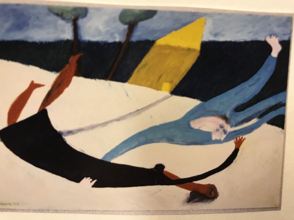
- Title
- Violation
- Date
- 1979
- Medium
- oil on paper
- Description
- A woman in black dress and a man in a blue suit fly, twisting through the air. A yellow house in the background with a grey road leading up to it. Dark green grass and two trees surround the house.
- Credit
- Gift of Harold C. Whyte, Penticton, 2003
- Catalogue Number
- ZeJ.02.01
Images
This material is presented as originally created; it may contain outdated cultural descriptions and
potentially offensive content.
Read more.
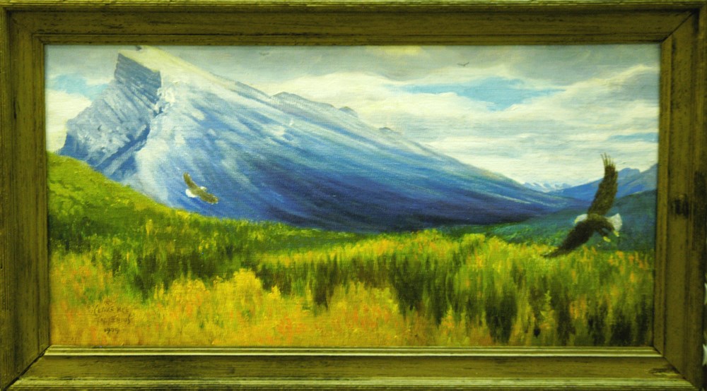
Eagles Over Mt. Rundle
https://archives.whyte.org/en/permalink/artifacttic.02.15
- Date
- 1979
- Medium
- oil on canvas board
- Catalogue Number
- TiC.02.15
- Description
- In the distance a mountain begins at a low area at the right of the image. This mountain gets larger as it proceeds to the left side of the image. In the top left corner the mountain peak is covered with snow. The foreground and the area between that and the mountain is solid trees of green, yellow…
1 image
- Title
- Eagles Over Mt. Rundle
- Date
- 1979
- Medium
- oil on canvas board
- Dimensions
- 25.4 x 51.0 cm
- Description
- In the distance a mountain begins at a low area at the right of the image. This mountain gets larger as it proceeds to the left side of the image. In the top left corner the mountain peak is covered with snow. The foreground and the area between that and the mountain is solid trees of green, yellow and orange. Two eagles soar over the tops of the trees, one from the left and one from the right. The sky in the background has a bit of blue with several white and grey clouds.
- Credit
- Gift of Clarence Ingwall Tillenius, Winnipeg, 1996
- Catalogue Number
- TiC.02.15
Images
This material is presented as originally created; it may contain outdated cultural descriptions and
potentially offensive content.
Read more.
Topographic map, Mount Brimston, Y.T.
https://archives.whyte.org/en/permalink/catalogue23750
- Medium
- Library - Maps and blueprints (unannotated; published)
- Map
- Published Date
- 1978
- Call Number
- NTS
- 116G/11
- Published Date
- 1978
- Scale
- 1:50,000
- Subjects
- Mount Brimston - Y.T.
- Notes
- Nahoni Range (Ogilvie Mountains)
- Accession Number
- 11,500
- Call Number
- NTS
- 116G/11
- Collection
- Archives Library
This material is presented as originally created; it may contain outdated cultural descriptions and
potentially offensive content.
Read more.
Topographic map of the Mount Carter area in the Yukon Territory, Ogilvie Mountains. Blackstone River
https://archives.whyte.org/en/permalink/catalogue23751
- Medium
- Library - Maps and blueprints (unannotated; published)
- Map
- Published Date
- 1978
- Publisher
- D.E.M.R.
- Call Number
- NTS
- 116H/11
- Publisher
- D.E.M.R.
- Published Date
- 1978
- Scale
- 1:50,000
- Subjects
- Mount Carter - Y.T.
- Accession Number
- 11,500
- Call Number
- NTS
- 116H/11
- Collection
- Archives Library
This material is presented as originally created; it may contain outdated cultural descriptions and
potentially offensive content.
Read more.
Topo map of the Mount Kinney, Yukon Territory region, Hart River, Nethro Mountain
https://archives.whyte.org/en/permalink/catalogue23761
- Medium
- Library - Maps and blueprints (unannotated; published)
- Map
- Published Date
- 1978
- Publisher
- DEMR
- Call Number
- NTS
- 116H/3
- Publisher
- DEMR
- Published Date
- 1978
- Scale
- 1:50,000
- Subjects
- Mount Kinney - Y.T.
- Accession Number
- 11,500
- Call Number
- NTS
- 116H/3
- Collection
- Archives Library
This material is presented as originally created; it may contain outdated cultural descriptions and
potentially offensive content.
Read more.
Mount Revelstoke, British Columbia
https://archives.whyte.org/en/permalink/catalogue23767
- Medium
- Library - Maps and blueprints (unannotated; published)
- Map
- Published Date
- 1978
- Publisher
- Ottawa : Surveys and Mapping Branch, Dept. of Energy, Mines and Resources
- Edition
- 2d ed.
- Call Number
- NTS
- 82M/1
- Edition
- 2d ed.
- Publisher
- Ottawa : Surveys and Mapping Branch, Dept. of Energy, Mines and Resources
- Published Date
- 1978
- Physical Description
- 1 map : col
- Scale
- 1:50,000
- Subjects
- Revelstoke, Mount
- Mount Revelstoke (B.C.)
- Accession Number
- 27,000
- Call Number
- NTS
- 82M/1
- Collection
- Archives Library
This material is presented as originally created; it may contain outdated cultural descriptions and
potentially offensive content.
Read more.
Topographic map of the Mount Turner region in the Yukon Territories, Ogilvie Mountains. Clear Creek
https://archives.whyte.org/en/permalink/catalogue23776
- Medium
- Library - Maps and blueprints (unannotated; published)
- Map
- Published Date
- 1978
- Publisher
- D.E.M.R.
- Call Number
- NTS
- 116H/8
- Publisher
- D.E.M.R.
- Published Date
- 1978
- Scale
- 1:50,000
- Subjects
- Mount Turner - Y.T.
- Accession Number
- 11,500
- Call Number
- NTS
- 116H/8
- Collection
- Archives Library
This material is presented as originally created; it may contain outdated cultural descriptions and
potentially offensive content.
Read more.
Topographic map of Mount Whitney, Yukon Territory area, Miner River, Mount Whitney
https://archives.whyte.org/en/permalink/catalogue23783
- Medium
- Library - Maps and blueprints (unannotated; published)
- Map
- Published Date
- 1978
- Call Number
- NTS
- 116G/12
- Published Date
- 1978
- Scale
- 1:50,000
- Subjects
- Mount Whitney - Y.T.
- Accession Number
- 11,500
- Call Number
- NTS
- 116G/12
- Collection
- Archives Library
This material is presented as originally created; it may contain outdated cultural descriptions and
potentially offensive content.
Read more.