Narrow Results By
- Moore family fonds 551
- Boorne and May fonds 167
- Luxton family fonds 158
- Charles Macmunn fonds 145
- Bruno Engler fonds 114
- Archives General File Collection 50
- Kidney family fonds 45
- Nicholas Morant fonds 40
- George McLean fonds 38
- Trail Riders of the Canadian Rockies fonds 37
- Peter and Catharine Whyte fonds 33
- Alpine Club of Canada fonds 32
- Date
- 2015 – 2015
- Material
- glass; paper
- Catalogue Number
- 110.01.1071
- Description
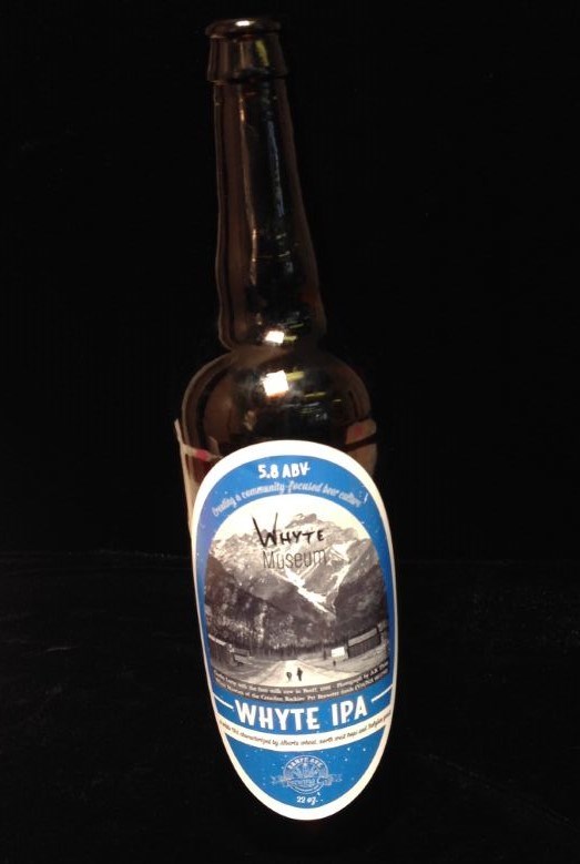
- 1 empty bottle of Whyte IPA by Banff Avenue Brewing Company established 2010. 2015 Whyte Museum logo on image of Charles Lefroy with the first milk cow in Banff, 1888. Photograph by A.B. Thom Whyte Museum of the Canadian ROckeis. Pat Brewster fonds (V91/NA66-1796) 27x8cmlabel reads “Banff Avenue Br…
1 image
- Title
- Beer Bottle
- Date
- 2015 – 2015
- Material
- glass; paper
- Dimensions
- 27 x 8 cm
- Description
- 1 empty bottle of Whyte IPA by Banff Avenue Brewing Company established 2010. 2015 Whyte Museum logo on image of Charles Lefroy with the first milk cow in Banff, 1888. Photograph by A.B. Thom Whyte Museum of the Canadian ROckeis. Pat Brewster fonds (V91/NA66-1796) 27x8cmlabel reads “Banff Avenue Brewing Company Whyte IPA”
- Subject
- beer
- bottle
- IPA
- Banff Brewing Company
- Credit
- Gift of Unknown, 2015
- Catalogue Number
- 110.01.1071
Images
This material is presented as originally created; it may contain outdated cultural descriptions and
potentially offensive content.
Read more.
2002 race award ceremony
https://archives.whyte.org/en/permalink/descriptions54388
- Scope & Content
- File consists of 54 colour photographs pertaining to the awards ceremony for Bruno Engler's Memorial Ski Race held in 2002. Images depict trophies won in the ski race, and various unnamed individuals accepting or presenting awards.
- Date Range
- 2002
- Reference Code
- V783 / II / PA - 70 to 123
- Description Level
- 5 / File
- GMD
- Photograph
- Photograph print
- Description Level
- 5 / File
- Fonds Number
- M559 / V783
- Series
- V783 / II : 1991 - 2016
- Sous-Fonds
- V783
- Accession Number
- 2018.8688
- Reference Code
- V783 / II / PA - 70 to 123
- Date Range
- 2002
- Physical Description
- 54 photographs : col. prints ; 15 x 10 cm
- Scope & Content
- File consists of 54 colour photographs pertaining to the awards ceremony for Bruno Engler's Memorial Ski Race held in 2002. Images depict trophies won in the ski race, and various unnamed individuals accepting or presenting awards.
- Notes
- Photographs not removed from original labelled/numbered sheets to maintain original order and context.
- Archival reference code numbers [V783/II/PA-70 to 123] follow original letter codes of photos written on mylar cases [V783/II/PA-70 is photo "A1", PA-71 is photo "A2", etc.]
- Subject Access
- Award
- Ceremony
- Memorial
- Skiing
- Ski racing
- Sports
- Winter sports
- Geographic Access
- Canada
- Alberta
- Banff
- Access Restrictions
- Copyright restrictions may apply
- Reproduction Restrictions
- Copyright restrictions may apply
- Language
- English
- Conservation
- Items appear to be safe remaining in original state of storage in protective sleeves. Consider removing photographs in the future if off-gassing becomes a concern.
- Category
- Sports, recreation and leisure
- Title Source
- Title based on contents of file
- Processing Status
- Processed
This material is presented as originally created; it may contain outdated cultural descriptions and
potentially offensive content.
Read more.
Golden : British Columbia Alberta west of fifth meridian
https://archives.whyte.org/en/permalink/catalogue24234
- Medium
- Library - Maps and blueprints (unannotated; published)
- Map
- Published Date
- 1997
- Publisher
- Natural Resources Canada
- Call Number
- NTS
- 82N
- Publisher
- Natural Resources Canada
- Published Date
- 1997
- Physical Description
- 1 map : col
- Scale
- 1:250,000
- Subjects
- Golden
- British Columbia
- Surveys and Mapping
- Notes
- National Topographic System
- Accession Number
- 30500 3.2.98
- Call Number
- NTS
- 82N
- Collection
- Archives Library
This material is presented as originally created; it may contain outdated cultural descriptions and
potentially offensive content.
Read more.
Burnt Timber Creek, Alberta
https://archives.whyte.org/en/permalink/catalogue23521
- Medium
- Library - Maps and blueprints (unannotated; published)
- Map
- Published Date
- 1996
- Publisher
- Nepean (Ont.) : Canada Map Office
- Edition
- 3d ed.
- Call Number
- NTS
- 820/11
- Edition
- 3d ed.
- Publisher
- Nepean (Ont.) : Canada Map Office
- Published Date
- 1996
- Physical Description
- 1 map : col
- Scale
- Scale: 1:50,000
- Subjects
- Burnt Timber Creek
- Alberta
- Notes
- Information current as of 1994
- Accession Number
- 29,000
- Call Number
- NTS
- 820/11
- Collection
- Archives Library
This material is presented as originally created; it may contain outdated cultural descriptions and
potentially offensive content.
Read more.
Mount Wheeler, Kootenay Land District, British Columbia
https://archives.whyte.org/en/permalink/catalogue23780
- Medium
- Library - Maps and blueprints (unannotated; published)
- Map
- Published Date
- 1996
- Publisher
- Nepean (Ont.) : Canada Map Office
- Edition
- 4th ed.
- Call Number
- NTS
- 82N/3
- Edition
- 4th ed.
- Publisher
- Nepean (Ont.) : Canada Map Office
- Published Date
- 1996
- Physical Description
- 1 map : col
- Scale
- 1:50,000
- Subjects
- Wheeler, Mount
- Notes
- Information current as of 1994
- Accession Number
- 29,000
- Call Number
- NTS
- 82N/3
- Collection
- Archives Library
This material is presented as originally created; it may contain outdated cultural descriptions and
potentially offensive content.
Read more.
Radium Hot Springs, Kootenay Land District, British Columbia
https://archives.whyte.org/en/permalink/catalogue23831
- Medium
- Library - Maps and blueprints (unannotated; published)
- Map
- Published Date
- 1996
- Publisher
- Nepean (Ont.) : Canada Map Office
- Edition
- 3d ed.
- Call Number
- NTS
- 82K/9
- Edition
- 3d ed.
- Publisher
- Nepean (Ont.) : Canada Map Office
- Published Date
- 1996
- Physical Description
- 1 map : col
- Scale
- 1:50,000
- Subjects
- Radium Hot Springs (B.C.)
- Notes
- Information current as of 1994
- Accession Number
- 29,000
- Call Number
- NTS
- 82K/9
- Collection
- Archives Library
This material is presented as originally created; it may contain outdated cultural descriptions and
potentially offensive content.
Read more.
Rostrum Peak, British Columbia/Alberta
https://archives.whyte.org/en/permalink/catalogue23856
- Medium
- Library - Maps and blueprints (unannotated; published)
- Map
- Published Date
- 1996
- Publisher
- Nepean (Ont.) : Canada Map Office
- Edition
- 3rd edition
- Call Number
- NTS
- 82N/14
- Edition
- 3rd edition
- Publisher
- Nepean (Ont.) : Canada Map Office
- Published Date
- 1996
- Physical Description
- 1 map : col
- Scale
- Scale: 1:50,000
- Subjects
- British Columbia
- Alberta
- Notes
- Information current as of 1994
- Accession Number
- 29,000
- Call Number
- NTS
- 82N/14
- Collection
- Archives Library
This material is presented as originally created; it may contain outdated cultural descriptions and
potentially offensive content.
Read more.
Sullivan River, Kootenay Land District, British Columbia
https://archives.whyte.org/en/permalink/catalogue23908
- Medium
- Library - Maps and blueprints (unannotated; published)
- Map
- Published Date
- 1996
- Publisher
- Nepean (Ont.) : Canada Map Office
- Edition
- 3d ed.
- Call Number
- NTS
- 82N/13
- Edition
- 3d ed.
- Publisher
- Nepean (Ont.) : Canada Map Office
- Published Date
- 1996
- Physical Description
- 1 map : col
- Scale
- 1:50,000
- Subjects
- Sullivan River (B.C.)
- Notes
- Information current as of 1994
- Accession Number
- 29,000
- Call Number
- NTS
- 82N/13
- Collection
- Archives Library
This material is presented as originally created; it may contain outdated cultural descriptions and
potentially offensive content.
Read more.
Mountain Park : Alberta west of fifth meridian
https://archives.whyte.org/en/permalink/catalogue24235
- Medium
- Library - Maps and blueprints (unannotated; published)
- Map
- Published Date
- 1996
- Publisher
- Ottawa : Natural Resources Canada
- Edition
- 3 ed
- Call Number
- NTS
- 83 C14
- Edition
- 3 ed
- Publisher
- Ottawa : Natural Resources Canada
- Published Date
- 1996
- Physical Description
- 1 map : col
- Scale
- Scale: 1:50,000
- Relief: contour interval 20 metres below 2000 metres; contour interval 40 metres above 2000 metres
- Notes
- Partial contents: includes Mountain Park Provincial Forest Recreation Area and Cardinal River Provincial Forest Recreation Area
- Accession Number
- 30500 6.25.98
- Call Number
- NTS
- 83 C14
- Collection
- Archives Library
This material is presented as originally created; it may contain outdated cultural descriptions and
potentially offensive content.
Read more.
Miette : Alberta west of fifth meridian
https://archives.whyte.org/en/permalink/catalogue24236
- Medium
- Library - Maps and blueprints (unannotated; published)
- Map
- Published Date
- 1996
- Publisher
- Ottawa : Natural Resources Canada
- Edition
- 3 ed
- Call Number
- NTS
- 83 F4
- Edition
- 3 ed
- Publisher
- Ottawa : Natural Resources Canada
- Published Date
- 1996
- Physical Description
- 1 map : col
- Scale
- Scale: 1:50,000
- Relief: Contour interval 100'
- Accession Number
- 30500 3.2.98
- Call Number
- NTS
- 83 F4
- Collection
- Archives Library
This material is presented as originally created; it may contain outdated cultural descriptions and
potentially offensive content.
Read more.
Snaring River : Improvement District 12 Alberta west of fifth meridian
https://archives.whyte.org/en/permalink/catalogue24237
- Medium
- Library - Maps and blueprints (unannotated; published)
- Map
- Published Date
- 1996
- Publisher
- Natural Resources Canada
- Edition
- 4 ed
- Call Number
- NTS
- 83 E1
- Edition
- 4 ed
- Publisher
- Natural Resources Canada
- Published Date
- 1996
- Physical Description
- 1 map : col
- Scale
- Relief: Contour interval 100'
- Scale: 1:50,000
- Accession Number
- 30500 3.2.98
- Call Number
- NTS
- 83 E1
- Collection
- Archives Library
This material is presented as originally created; it may contain outdated cultural descriptions and
potentially offensive content.
Read more.
Clemenceau Icefield : British Columbia Alberta Colombie-Britannique Alberta
https://archives.whyte.org/en/permalink/catalogue24238
- Medium
- Library - Maps and blueprints (unannotated; published)
- Map
- Published Date
- 1996
- Publisher
- Ottawa : Natural Resources Canada
- Edition
- 3 ed
- Call Number
- NTS
- 83 C4
- Edition
- 3 ed
- Publisher
- Ottawa : Natural Resources Canada
- Published Date
- 1996
- Physical Description
- 1 map : col
- Scale
- Scale: 1:50,000
- Relief: Contour Interval 40 metres
- Accession Number
- 30500 3.2.98
- Call Number
- NTS
- 83 C4
- Collection
- Archives Library
This material is presented as originally created; it may contain outdated cultural descriptions and
potentially offensive content.
Read more.
Sunwapta Peak : Alberta
https://archives.whyte.org/en/permalink/catalogue24239
- Medium
- Library - Maps and blueprints (unannotated; published)
- Map
- Published Date
- 1996
- Publisher
- Ottawa : Natural Resources Canada
- Edition
- 3 ed
- Call Number
- NTS
- 83 C6
- Edition
- 3 ed
- Publisher
- Ottawa : Natural Resources Canada
- Published Date
- 1996
- Physical Description
- 1 map : col
- Scale
- Scale: 1:50,000
- Relief: contour interval 20 metres below 2000 metres, 40 metres above 200 metres
- Accession Number
- 30500 3.2.98
- Call Number
- NTS
- 83 C6
- Collection
- Archives Library
This material is presented as originally created; it may contain outdated cultural descriptions and
potentially offensive content.
Read more.
Athabasca Falls : Improvement District 12 Alberta
https://archives.whyte.org/en/permalink/catalogue24240
- Medium
- Library - Maps and blueprints (unannotated; published)
- Map
- Published Date
- 1996
- Publisher
- Ottawa : Natural Resources Canada
- Edition
- 3 ed
- Call Number
- NTS
- 83 C12
- Edition
- 3 ed
- Publisher
- Ottawa : Natural Resources Canada
- Published Date
- 1996
- Physical Description
- 1 map : col
- Scale
- Scale: 1:50,000
- Relief: contour interval 20 metres below 2000 metres, 40 metres above 2000 metres
- Accession Number
- 30500 3.2.98
- Call Number
- NTS
- 83 C12
- Collection
- Archives Library
This material is presented as originally created; it may contain outdated cultural descriptions and
potentially offensive content.
Read more.
Medicine Lake : Alberta
https://archives.whyte.org/en/permalink/catalogue24241
- Medium
- Library - Maps and blueprints (unannotated; published)
- Map
- Published Date
- 1996
- Publisher
- Ottawa : Natural Resources Canada
- Edition
- 4 ed
- Call Number
- NTS
- 83 C13
- Edition
- 4 ed
- Publisher
- Ottawa : Natural Resources Canada
- Published Date
- 1996
- Physical Description
- 1 map : col
- Scale
- Scale: 1:50,000
- Relief: contour interval 20 metres below 2000 metres, 40 metres above 2000 metres
- Call Number
- NTS
- 83 C13
- Collection
- Archives Library
This material is presented as originally created; it may contain outdated cultural descriptions and
potentially offensive content.
Read more.
Mount Goodsir : British Columbia Alberta Colombie-Britannique Alberta west of fifth meridian ouest du cinquieme meridien
https://archives.whyte.org/en/permalink/catalogue24242
- Medium
- Library - Maps and blueprints (unannotated; published)
- Map
- Published Date
- 1996
- Publisher
- Ottawa : Natural Resources Canada
- Edition
- 3 ed
- Call Number
- NTS
- 82 N1
- Edition
- 3 ed
- Publisher
- Ottawa : Natural Resources Canada
- Published Date
- 1996
- Physical Description
- 1 map : col
- Scale
- Scale: 1:50,000
- Relief: Contour interval 40 metres
- Accession Number
- 30500 3.2.98
- Call Number
- NTS
- 82 N1
- Collection
- Archives Library
This material is presented as originally created; it may contain outdated cultural descriptions and
potentially offensive content.
Read more.
Golden : Kootenay Land District British Columbia Colombie-Britannique
https://archives.whyte.org/en/permalink/catalogue24243
- Medium
- Library - Maps and blueprints (unannotated; published)
- Map
- Published Date
- 1996
- Publisher
- Ottawa : Natural Resources Canada
- Edition
- 4 ed
- Call Number
- NTS
- 82 N7
- Edition
- 4 ed
- Publisher
- Ottawa : Natural Resources Canada
- Published Date
- 1996
- Physical Description
- 1 map : col
- Scale
- Scale: 1:50,000
- Relief: Contour interval 40 metres
- Accession Number
- 30500 3.2.98
- Call Number
- NTS
- 82 N7
- Collection
- Archives Library
This material is presented as originally created; it may contain outdated cultural descriptions and
potentially offensive content.
Read more.
McMurdo : Kootenay Land District British Columbia Colombie-Britannique
https://archives.whyte.org/en/permalink/catalogue24244
- Medium
- Library - Maps and blueprints (unannotated; published)
- Map
- Published Date
- 1996
- Publisher
- Ottawa : Natural Resources Canada
- Edition
- 4 ed
- Call Number
- NTS
- 82 N2
- Edition
- 4 ed
- Publisher
- Ottawa : Natural Resources Canada
- Published Date
- 1996
- Physical Description
- 1 map : col
- Scale
- Scale: 1:50,000
- Relief: Contour interval 40 metres
- Accession Number
- 30500 3.2.98
- Call Number
- NTS
- 82 N2
- Collection
- Archives Library
This material is presented as originally created; it may contain outdated cultural descriptions and
potentially offensive content.
Read more.
Lake Louise : Alberta British Columbia Alberta Colombie-Britannique west of fifth meridian ouest du cinquieme meridien
https://archives.whyte.org/en/permalink/catalogue24245
- Medium
- Library - Maps and blueprints (unannotated; published)
- Map
- Published Date
- 1996
- Publisher
- Ottawa : Natural Resources Canada
- Edition
- 7 ed
- Call Number
- NTS
- 82 N8
- Edition
- 7 ed
- Publisher
- Ottawa : Natural Resources Canada
- Published Date
- 1996
- Physical Description
- 1 map : col
- Scale
- Scale: 1:50,000
- Relief: contour interval 40 metres
- Accession Number
- 30500 3.2.98
- Call Number
- NTS
- 82 N8
- Collection
- Archives Library
This material is presented as originally created; it may contain outdated cultural descriptions and
potentially offensive content.
Read more.
Hector Lake : Alberta British Columbia Alberta Colombie-Britannique west of fifth meridian ouest du cinquieme meridien
https://archives.whyte.org/en/permalink/catalogue24246
- Medium
- Library - Maps and blueprints (unannotated; published)
- Map
- Published Date
- 1996
- Publisher
- Ottawa : Natural Resources Canada
- Edition
- 3 ed
- Call Number
- NTS
- 82 N9
- Edition
- 3 ed
- Publisher
- Ottawa : Natural Resources Canada
- Published Date
- 1996
- Physical Description
- 1 map : col
- Scale
- Scale: 1:50,000
- Relief: Contour interval 40 metres
- Accession Number
- 30500 3.2.98
- Call Number
- NTS
- 82 N9
- Collection
- Archives Library
This material is presented as originally created; it may contain outdated cultural descriptions and
potentially offensive content.
Read more.