Narrow Results By
- Byron Harmon fonds 3031
- Peter and Catharine Whyte fonds 236
- Vaux family fonds 186
- Luxton family fonds 140
- Elliott Barnes fonds 122
- Mary (Molly) Wright Adams fonds 110
- Tom Wilson family fonds 103
- Mary Schaffer fonds 42
- Moore family fonds 38
- Joe Kootenay fonds 25
- Kidney family fonds 19
- George Paris fonds 15
Sectional map
https://archives.whyte.org/en/permalink/catalogue24461
- Medium
- Library - Maps and blueprints (unannotated; published)
- Map
- Published Date
- 1909
- Publisher
- Dept. of the Interior, Ottawa
- Call Number
- C9-6.1
- Publisher
- Dept. of the Interior, Ottawa
- Published Date
- 1909
- Scale
- 6 miles: 1 inch
- Subjects
- Pincher Creek Sheet
- Accession Number
- 400
- Call Number
- C9-6.1
- Collection
- Archives Library
This material is presented as originally created; it may contain outdated cultural descriptions and
potentially offensive content.
Read more.
Sectional map
https://archives.whyte.org/en/permalink/catalogue24462
- Medium
- Library - Maps and blueprints (unannotated; published)
- Map
- Published Date
- 1909
- Publisher
- Dept. of the Interior, Ottawa
- Call Number
- C9-6.2
- Publisher
- Dept. of the Interior, Ottawa
- Published Date
- 1909
- Scale
- 6 miles: 1 inch
- Subjects
- Lethbridge Sheet
- Accession Number
- 400
- Call Number
- C9-6.2
- Collection
- Archives Library
This material is presented as originally created; it may contain outdated cultural descriptions and
potentially offensive content.
Read more.
Sectional Map, Special Edition showing Lands disposed of
https://archives.whyte.org/en/permalink/catalogue24589
- Medium
- Library - Maps and blueprints (unannotated; published)
- Map
- Published Date
- 1909
- Call Number
- C11-6.12
- Published Date
- 1909
- Scale
- 6 miles - 1 inch
- Notes
- References: Trails, Trails surveyed, Post Offices, Railway Stations, Range numbers, Township numbers......
- Accession Number
- 400
- Call Number
- C11-6.12
- Collection
- Archives Library
This material is presented as originally created; it may contain outdated cultural descriptions and
potentially offensive content.
Read more.
CPR Plan and Profile of Line Change, Rogers Pass
https://archives.whyte.org/en/permalink/catalogue24796
- Medium
- Library - Maps and blueprints (unannotated; published)
- Map
- Published Date
- 1909
- Call Number
- C12-1.28
- Published Date
- 1909
- Scale
- 400 feet to the inch
- Subjects
- Rogers Pass
- Notes
- Photostatic copy from the B.C. Provincial Archives
- Accession Number
- 2353
- Call Number
- C12-1.28
- Collection
- Archives Library
This material is presented as originally created; it may contain outdated cultural descriptions and
potentially offensive content.
Read more.
- Part Of
- Vaux family fonds
- Date Range
- 1909
- Reference Code
- V653 / NA - 586 to 623, 1567 to 1633
- Description Level
- 4 / Sub-series
- GMD
- Photograph
- Negative
- Part Of
- Vaux family fonds
- Description Level
- 4 / Sub-series
- Fonds Number
- M107/V653
- Series
- I. Photography
- Sous-Fonds
- V653
- Reference Code
- V653 / NA - 586 to 623, 1567 to 1633
- GMD
- Photograph
- Negative
- Date Range
- 1909
- Physical Description
- 105 photographs : negatives; film, 4x5" and 6.5x8.5"
- Access Restrictions
- Access by appointment only
- Title Source
- Title based on contents of file
- Content Details
- ITEM LIST OF 4x5" NEGATIVES (V653/NA - 586 to 623) :
- [Note: Repeat descriptions have been combined by the archivist]
- 586-623 Canadian Pacific trip -- 8/1909 -- [Views pertain to Montreal? (586); Winnipeg? (587); Mount Tuzo and Mount Deltaform (588); pack trip; avalanche (592,593); Alpine Club camp at Lake O'Hara (595-598); glacier; Mount Balfour and Lake Margaret (601-603); Yoho Valley from below Lake Margaret (604); Mount Daly, Mount Niles and Daly Glacier (605); Daly Glacier and Takakkaw Falls? (606); Takakkaw Falls (607); Twin Falls (608,609); Yoho Glacier (610,611,615-617); ice cave at Yoho Glacier (612-614)]; Mt. Sir Donald? (619); unidentified scenes (594,618,620-623)]
- ITEM LIST OF 6.5 x 8.5" NEGATIVES (V653/NA - 1567 to 1633) :
- 1567 Glacier -- 1909
- 1568-1571 Ice on Illecillewaet Glacier (poor) -- 1909
- 1572-1575 Glacier -- 1909
- 1576-1579 Asulkan Glacier Pan -- 1909
- 1580 Illecillewaet Glacier Pan -- 1909
- 1581-1585 Panorama from Illecillewaet Glacier -- 1909
- 1586-1587 Ice panorama Illecillewaet Glacier -- 1909
- 1588-1589 Ice pinnacle & figure Illecillewaet Glacier -- 1909
- 1590 Test picture Asulkan Glacier -- 1909
- 1591-1593 Camp of ACC at Lake O'Hara Pan -- 1909
- 1594-1595 ACC camp at Lake O'Hara Pan -- 1909
- 1596-1600 Meadow & ACC camp Lake O'Hara -- 1909
- 1601-1605 Victoria Hungabee etc. from (meadow?) above Lake O'Hara -- 1909
- 1606-1608 Hungabee and Victoria from (meadow?) above Lake O'Hara -- 1909
- 1609-1615 Field Hill -- 1909
- 1616 Mt. Stephen from meadow on road to Yoho Valley (storm clouds) 1909
- 1617-1620 Takakkaw Falls poor (No.7,8,9,10) -- 1909
- 1621 Chalet Lake Louise -- 1909
- 1622 Lake Louise Chalet -- 1909
- 1623 Chalet from across Lake Louise -- 1909
- 1624 Looking up Abbott Pass (poorest) -- 1909
- 1625 Abbott Pass -- 1909
- 1626-1629 Lake Louise -- 1909
- 1630-1632 Lake Louise panorama -- 1909
- 1633 Lake Louise & Chalet from Victoria Glacier -- 1909
- Processing Status
- Processed
This material is presented as originally created; it may contain outdated cultural descriptions and
potentially offensive content.
Read more.
Stoney Indian mother and children
https://archives.whyte.org/en/permalink/descriptions49095
- Part Of
- Tom Wilson family fonds
- Date Range
- 1909
- Reference Code
- NA66 - 595
- Description Level
- 6 / Item
- GMD
- Photograph
- Negative, copy
- Part Of
- Tom Wilson family fonds
- Description Level
- 6 / Item
- Fonds Number
- V701
- Sous-Fonds
- .
- Sub-Series
- .
- Reference Code
- NA66 - 595
- Date Range
- 1909
- Physical Description
- Copy from book
- Notes
- Note: Any descriptive information or identification of people has been provided by research done through the Recognizing Relations
- Subject Access
- First Nations
- Recognizing Relations Collection
- Geographic Access
- Alberta
- Creator
- Walter Wilcox
- Title Source
- Stoney Nakoda Elders provided naming and other culturally relevant information during interviews held for Recognizing Relations, an archives initiative active from 2014-2023. The goal of this initiative was to name local Indigenous peoples in photographs held in the WMCR archives as well as encouraging access for Indigenous communities to these images. See: "The Rockies of Canada" by W.Wilcox,1909. [p.291], text implies this is Tom Chiniquay jr.'s family
- Content Details
- .
- Processing Status
- Processed
This material is presented as originally created; it may contain outdated cultural descriptions and
potentially offensive content.
Read more.
Annual meeting of Alpine Club of Canada, secretary (Elizabeth Parker) reading her report [Lake O'Hara, Yoho Park, B.C.]
https://archives.whyte.org/en/permalink/descriptions49267
- Part Of
- Alpine Club of Canada fonds
- Scope & Content
- Image of a woman identified as Elizabeth Parker reading her report to the Alpine Club of Canada memebers at Lake O'Hara
- Date Range
- 1909
- Reference Code
- v14 / ac55 / 5 / 984 / na66 - 2131
- Description Level
- 6 / Item
- GMD
- Photograph
- Negative, copy
1 image
- Part Of
- Alpine Club of Canada fonds
- Description Level
- 6 / Item
- Fonds Number
- V14
- Sous-Fonds
- .
- Reference Code
- v14 / ac55 / 5 / 984 / na66 - 2131
- Date Range
- 1909
- Physical Description
- 1 photograph : negative : copy negative
- Scope & Content
- Image of a woman identified as Elizabeth Parker reading her report to the Alpine Club of Canada memebers at Lake O'Hara
- Subject Access
- Women
- Discovery and Exploration
- Environment and Nature
- Organizations
- Sports and Recreation
- Geographic Access
- Alberta
- British Columbia
- Creator
- Frank W. Freeborn
- Title Source
- copy negative envelope
- Processing Status
- Processed
Images

This material is presented as originally created; it may contain outdated cultural descriptions and
potentially offensive content.
Read more.
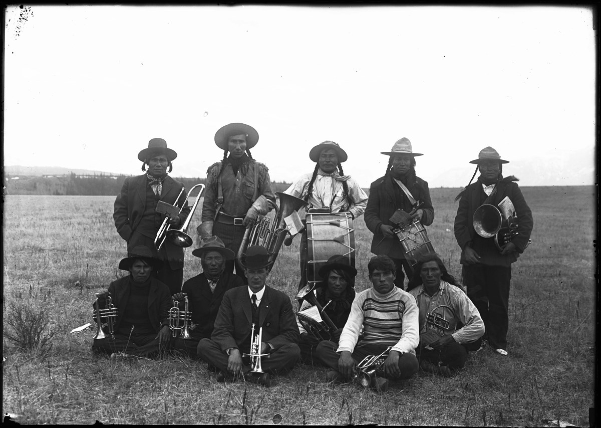
Stoney Nakoda musicians
https://archives.whyte.org/en/permalink/descriptions37912
- Part Of
- Elliott Barnes fonds
- Scope & Content
- Stoney Nakoda Band [musicians]
- Date Range
- 1909
- Reference Code
- V48 / NG - 32
- Description Level
- 6 / Item
- GMD
- Photograph
1 image
- Part Of
- Elliott Barnes fonds
- Description Level
- 6 / Item
- Fonds Number
- V48
- Series
- I. Negative series
- Sous-Fonds
- V48
- Reference Code
- V48 / NG - 32
- GMD
- Photograph
- Date Range
- 1909
- Physical Description
- 1 photograph : negative, glass, 13 x 18 cm or smaller
- Scope & Content
- Stoney Nakoda Band [musicians]
- Subject Access
- Family and personal life
- First nations
- Geographic Access
- Alberta
- Creator
- Elliott Barnes
- Title Source
- Title based on contents of file
- Processing Status
- Processed
Images
This material is presented as originally created; it may contain outdated cultural descriptions and
potentially offensive content.
Read more.
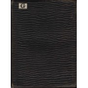
July and August Album
https://archives.whyte.org/en/permalink/descriptions57669
- Part Of
- Alpine Club of Canada fonds
- Scope & Content
- Item consists of 1 photograph album compiled by Frank W. Freeborn of New York City for the Alpine Club of Canada. The album pertains to a 1909 ACC trip in and around Lake Louise, Banff, Lake O'Hara, and Field, as well as the Mt. Hood area of Oregon, and includes black and white photographs, all of …
- Date Range
- 1909
- Reference Code
- V14 / AC 55P / PD - 5
- Description Level
- 6 / Item
- GMD
- Album
- Photograph
1 image
1 Electronic Resource
- Part Of
- Alpine Club of Canada fonds
- Description Level
- 6 / Item
- Fonds Number
- M200 / S6 / V14
- Series
- IV.B. Other material: photographic
- Sous-Fonds
- V14
- Accession Number
- 5200
- Reference Code
- V14 / AC 55P / PD - 5
- GMD
- Album
- Photograph
- Date Range
- 1909
- Physical Description
- 1 album (194 photographs : b&w and col. ; 20.3 x 25.5 cm)
- Scope & Content
- Item consists of 1 photograph album compiled by Frank W. Freeborn of New York City for the Alpine Club of Canada. The album pertains to a 1909 ACC trip in and around Lake Louise, Banff, Lake O'Hara, and Field, as well as the Mt. Hood area of Oregon, and includes black and white photographs, all of which are annotated in white ink. A small white paper with "G" printed on it is adhered to the top left corner of the front cover and "1909" is written in white ink in the middle of the front cover.
- Name Access
- Alpine Club of Canada
- Subject Access
- Activities
- Alpine Club of Canada
- Animals
- Backpacking
- Bow Falls
- Bow River
- Bow Valley
- Buildings
- Camps
- Canadian Pacific Railway
- Chateau Lake Louise
- Climbing
- Clothing and dress
- Club
- Environment and Nature
- Glaciers
- Hiking
- Hotels
- Lake Louise
- Lake O'hara
- Landscapes
- Mountaineering
- Mountaineers
- Mountains
- Period costume
- Photography
- Portrait
- Railways
- Scenery
- scenic
- Trails
- Trains
- Transportation
- Geographic Access
- Lake Louise
- Banff National Park
- Alberta
- Field
- Yoho National Park
- Oregon
- Language
- English
- Finding Aid
- Inventory of the Alpine Club of Canada Collection, 1986, provides group or item-level description to this material
- Title Source
- Title based on item
- Processing Status
- Processed
Electronic Resources
Images

This material is presented as originally created; it may contain outdated cultural descriptions and
potentially offensive content.
Read more.
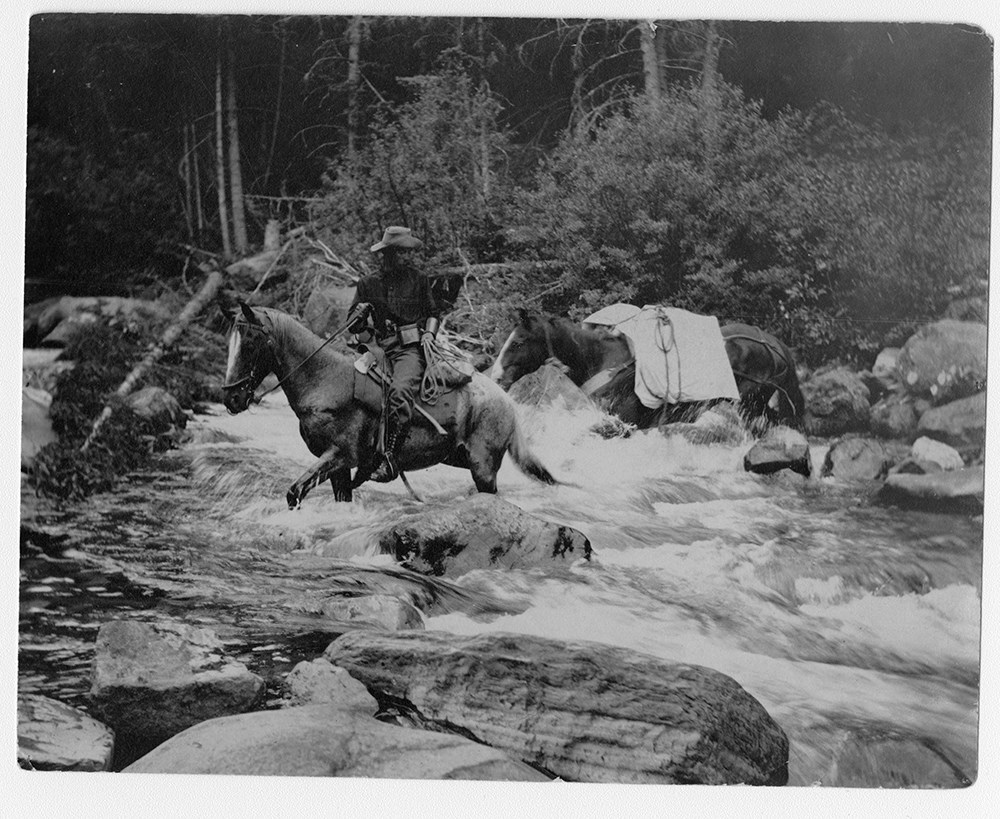
F.H. Riggall and packhourse crossing Boundary Creek
https://archives.whyte.org/en/permalink/descriptions53797
- Part Of
- Bert Riggall fonds
- Scope & Content
- Image depicts Bert Riggall and packhorse crossing Boundary Creek with Phillip R. Goodwin, artist of New York, in August, 1909.
- Date Range
- 1909
- Reference Code
- V26 / III / A1 / PA - 7
- Description Level
- 6 / Item
- GMD
- Photograph
- Photograph print
1 image
- Part Of
- Bert Riggall fonds
- Description Level
- 6 / Item
- Fonds Number
- M376 / V26
- Series
- III. Professional Photography: Guiding and Hunting Trips
- Sous-Fonds
- V26
- Sub-Series
- Goodwin and Proctor Trips
- Accession Number
- 7201
- Reference Code
- V26 / III / A1 / PA - 7
- Date Range
- 1909
- Physical Description
- 1 photograph : b&w print
- Scope & Content
- Image depicts Bert Riggall and packhorse crossing Boundary Creek with Phillip R. Goodwin, artist of New York, in August, 1909.
- Name Access
- Goodwin, Phillip R.
- Riggall, Bert
- Subject Access
- Environment and Nature
- Pack trips
- Exploration
- Horses
- Horse packing
- Geographic Access
- Canada
- British Columbia
- Boundary Creek
- Language
- N/A
- Title Source
- Title based on subject of item
- Processing Status
- Processed
Images
This material is presented as originally created; it may contain outdated cultural descriptions and
potentially offensive content.
Read more.
- Part Of
- Archives General File Collection
- Scope & Content
- File consists of one sketchbook. Sketch book consists of watercolour paintings
- Date Range
- 1909
- Reference Code
- M8 / 134
- Description Level
- 5 / File
- GMD
- Photograph
- Photograph print
- Part Of
- Archives General File Collection
- Description Level
- 5 / File
- Fonds Number
- M8 / V8 / S8
- Series
- 134
- Sous-Fonds
- M8
- Accession Number
- M8 / 134
- Reference Code
- M8 / 134
- Date Range
- 1909
- Physical Description
- 2.5 cm of textual records
- Scope & Content
- File consists of one sketchbook. Sketch book consists of watercolour paintings
- Name Access
- Welby, W.A
- Geographic Access
- Alberta
- Banff National Park
- Language
- English
- Creator
- Welby, W.A
- Title Source
- Title based on contents
- Processing Status
- Processed
This material is presented as originally created; it may contain outdated cultural descriptions and
potentially offensive content.
Read more.
Sectional map
https://archives.whyte.org/en/permalink/catalogue24463
- Medium
- Library - Maps and blueprints (unannotated; published)
- Map
- Published Date
- 1908
- Publisher
- Dept. of the Interior, Ottawa
- Call Number
- C9-6.3
- Publisher
- Dept. of the Interior, Ottawa
- Published Date
- 1908
- Scale
- 6 miles: 1 inch
- Subjects
- Porcupine Sheet
- Accession Number
- 400
- Call Number
- C9-6.3
- Collection
- Archives Library
This material is presented as originally created; it may contain outdated cultural descriptions and
potentially offensive content.
Read more.
Special edition map showing lands disposed of
https://archives.whyte.org/en/permalink/catalogue24586
- Medium
- Library - Maps and blueprints (unannotated; published)
- Map
- Published Date
- 1908
- Publisher
- Dept. of the Interior
- Call Number
- C11-6.9
- Publisher
- Dept. of the Interior
- Published Date
- 1908
- Scale
- 6 miles - 1 inch
- Subjects
- Canada - Prairie Region
- Manitoba
- Notes
- Sectional map
- References: Trails, Trails surveyed, Post Offices, Railway Stations, Range Numbers, Township numbers.....
- Accession Number
- 400
- Call Number
- C11-6.9
- Collection
- Archives Library
This material is presented as originally created; it may contain outdated cultural descriptions and
potentially offensive content.
Read more.
Special edition map showing lands disposed of
https://archives.whyte.org/en/permalink/catalogue24587
- Medium
- Library - Maps and blueprints (unannotated; published)
- Map
- Published Date
- 1908
- Publisher
- Dept. of the Interior
- Call Number
- C11-6.10
- Publisher
- Dept. of the Interior
- Published Date
- 1908
- Scale
- 6 miles - 1 inch
- Notes
- Sectional map
- References: Trails, Trails surveyed, Post Offices, Railway Stations, Range numbers, Township numbers...
- Accession Number
- 400
- Call Number
- C11-6.10
- Collection
- Archives Library
This material is presented as originally created; it may contain outdated cultural descriptions and
potentially offensive content.
Read more.
Special edition map showing lands disposed of
https://archives.whyte.org/en/permalink/catalogue24588
- Medium
- Library - Maps and blueprints (unannotated; published)
- Map
- Published Date
- 1908
- Publisher
- Dept. of the Interior
- Call Number
- C11-6.11
- Publisher
- Dept. of the Interior
- Published Date
- 1908
- Scale
- 6 miles - 1 inch
- Notes
- Sectional map
- References: Trails, Trails surveyed, Post Offices, Railway Stations, Range numbers, Township numbers....
- Accession Number
- 400
- Call Number
- C11-6.11
- Collection
- Archives Library
This material is presented as originally created; it may contain outdated cultural descriptions and
potentially offensive content.
Read more.
A sectional map, special edition showing Lands disposed of
https://archives.whyte.org/en/permalink/catalogue24590
- Medium
- Library - Maps and blueprints (unannotated; published)
- Map
- Published Date
- 1908
- Publisher
- Dept. of the Interior
- Call Number
- C11-6.13
- Publisher
- Dept. of the Interior
- Published Date
- 1908
- Scale
- 6 miles - 1 inch
- Notes
- References: Trails, Trails surveyed, Post Offices, Railway Stations, Range numbers, Township numbers....
- Accession Number
- 400
- Call Number
- C11-6.13
- Collection
- Archives Library
This material is presented as originally created; it may contain outdated cultural descriptions and
potentially offensive content.
Read more.
Sectional Map Showing Lands disposed of
https://archives.whyte.org/en/permalink/catalogue24591
- Medium
- Library - Maps and blueprints (unannotated; published)
- Map
- Published Date
- 1908
- Publisher
- Department of the Interior, Ottawa
- Call Number
- C11-6.14
- Publisher
- Department of the Interior, Ottawa
- Published Date
- 1908
- Scale
- 6 miles - 1 inch
- Notes
- References: Trails, Trails surveyed, Post Offices, Railway Stations, Range
- Accession Number
- 400
- Call Number
- C11-6.14
- Collection
- Archives Library
This material is presented as originally created; it may contain outdated cultural descriptions and
potentially offensive content.
Read more.
Sectional map, special edition, showing lands disposed of
https://archives.whyte.org/en/permalink/catalogue24592
- Medium
- Library - Maps and blueprints (unannotated; published)
- Map
- Published Date
- 1908
- Publisher
- Department of the Interior
- Call Number
- C11-6.15
- Publisher
- Department of the Interior
- Published Date
- 1908
- Scale
- 6 miles - 1 inch
- Notes
- References: Trails, Trails surveyed, Post Offices, Railway Stations, Range numbers
- Accession Number
- 400
- Call Number
- C11-6.15
- Collection
- Archives Library
This material is presented as originally created; it may contain outdated cultural descriptions and
potentially offensive content.
Read more.
Sectional map, special edition, showing lands disposed of
https://archives.whyte.org/en/permalink/catalogue24593
- Medium
- Library - Maps and blueprints (unannotated; published)
- Map
- Published Date
- 1908
- Publisher
- Department of the Interior
- Call Number
- C11-6.16
- Publisher
- Department of the Interior
- Published Date
- 1908
- Scale
- 6 miles - 1 inch
- Notes
- References: Trails, Trails surveyed, Post Offices, Railway Stations, Range numbers
- Accession Number
- 400
- Call Number
- C11-6.16
- Collection
- Archives Library
This material is presented as originally created; it may contain outdated cultural descriptions and
potentially offensive content.
Read more.
Sectional map, special edition, showing lands disposed of
https://archives.whyte.org/en/permalink/catalogue24594
- Medium
- Library - Maps and blueprints (unannotated; published)
- Map
- Published Date
- 1908
- Publisher
- Department of the Interior
- Call Number
- C11-6.17
- Publisher
- Department of the Interior
- Published Date
- 1908
- Scale
- 6 miles - 1 inch
- Notes
- References: Trails, Trails surveyed, Post Offices, Railway Stations, Range numbers
- Accession Number
- 400
- Call Number
- C11-6.17
- Collection
- Archives Library
This material is presented as originally created; it may contain outdated cultural descriptions and
potentially offensive content.
Read more.