Narrow Results By
- Peter and Catharine Whyte fonds 546
- Bruno Engler fonds 107
- Luxton family fonds 106
- Nicholas Morant fonds 98
- Douglas Leighton fonds 37
- George McLean fonds 37
- Kidney family fonds 27
- Trail Riders of the Canadian Rockies fonds 23
- Murray Hay fonds 19
- Archives General File Collection 15
- Ben Gadd fonds 14
- Hans Gmoser fonds 9
[Copton Creek, Alberta]
https://archives.whyte.org/en/permalink/catalogue23560
- Medium
- Library - Maps and blueprints (unannotated; published)
- Map
- Published Date
- 1979
- Publisher
- Dept. of Energy, Mines and Resources
- Edition
- Edition 2
- Call Number
- NTS
- 83L/3
- Edition
- Edition 2
- Publisher
- Dept. of Energy, Mines and Resources
- Published Date
- 1979
- Physical Description
- 1 map : col
- Scale
- Scale: 1:50,000
- Relief: Contour Interval 100 ft.
- Subjects
- Copton Creek
- Alberta
- Notes
- National Topographic System
- Accession Number
- 13,000
- Call Number
- NTS
- 83L/3
- Collection
- Archives Library
This material is presented as originally created; it may contain outdated cultural descriptions and
potentially offensive content.
Read more.
Hector Lake, Alberta-British Columbia
https://archives.whyte.org/en/permalink/catalogue23654
- Medium
- Library - Maps and blueprints (unannotated; published)
- Map
- Published Date
- 1979
- Publisher
- [Ottawa] : Surveys and Mapping Branch, Dept. of Energy, Mines and Resources
- Edition
- 2d ed.
- Call Number
- NTS
- 82N/9
- Edition
- 2d ed.
- Publisher
- [Ottawa] : Surveys and Mapping Branch, Dept. of Energy, Mines and Resources
- Published Date
- 1979
- Physical Description
- 1 map : col
- Scale
- 1:50,000
- Subjects
- Hector Lake (Alta./B.C.)
- Accession Number
- 27,000
- Call Number
- NTS
- 82N/9
- Collection
- Archives Library
This material is presented as originally created; it may contain outdated cultural descriptions and
potentially offensive content.
Read more.
Topographic map of the Mount Fyfe area, Yukon Territories, Ogilvie Mountains
https://archives.whyte.org/en/permalink/catalogue23756
- Medium
- Library - Maps and blueprints (unannotated; published)
- Map
- Published Date
- 1979
- Publisher
- D.E.M.R.
- Call Number
- NTS
- 116H/7
- Publisher
- D.E.M.R.
- Published Date
- 1979
- Scale
- 1:50,000
- Subjects
- Mount Fyfe - Y.T.
- Accession Number
- 11,500
- Call Number
- NTS
- 116H/7
- Collection
- Archives Library
This material is presented as originally created; it may contain outdated cultural descriptions and
potentially offensive content.
Read more.
[Nosehill Creek, Alberta]
https://archives.whyte.org/en/permalink/catalogue23800
- Medium
- Library - Maps and blueprints (unannotated; published)
- Map
- Published Date
- 1979
- Publisher
- Dept of Energy Mines and Resources
- Edition
- 2
- Call Number
- NTS
- 83F/15
- Edition
- 2
- Publisher
- Dept of Energy Mines and Resources
- Published Date
- 1979
- Physical Description
- Colour
- Scale
- Scale: 1:50,000
- Relief: Contour Interval 100 ft.
- Subjects
- Nosehill Creek, Alberta
- Notes
- National Topographic System
- Accession Number
- 13,000
- Call Number
- NTS
- 83F/15
- Collection
- Archives Library
This material is presented as originally created; it may contain outdated cultural descriptions and
potentially offensive content.
Read more.
Transportation Map of Alberta
https://archives.whyte.org/en/permalink/catalogue24403
- Medium
- Library - Maps and blueprints (unannotated; published)
- Map
- Published Date
- 1979
- Publisher
- Surveys and Mapping Branch, Alberta Transportation, Edmonton
- Call Number
- C9-1.13
- Publisher
- Surveys and Mapping Branch, Alberta Transportation, Edmonton
- Published Date
- 1979
- Scale
- Scale: 1:250,000
- Subjects
- Alberta Transportation
- Notes
- Red Deer 83A
- Accession Number
- 3235
- Call Number
- C9-1.13
- Collection
- Archives Library
This material is presented as originally created; it may contain outdated cultural descriptions and
potentially offensive content.
Read more.
Transportation map of Alberta
https://archives.whyte.org/en/permalink/catalogue24404
- Medium
- Library - Maps and blueprints (unannotated; published)
- Map
- Published Date
- 1979
- Publisher
- Surveys and Mapping Branch, Alberta Transportation, Edmonton
- Call Number
- C9-1.14
- Publisher
- Surveys and Mapping Branch, Alberta Transportation, Edmonton
- Published Date
- 1979
- Scale
- Scale: 1:250,000
- Subjects
- Alberta Transportation
- Notes
- Rocky Mountain House 83B
- Accession Number
- 3235
- Call Number
- C9-1.14
- Collection
- Archives Library
This material is presented as originally created; it may contain outdated cultural descriptions and
potentially offensive content.
Read more.
Transportation Map of Alberta
https://archives.whyte.org/en/permalink/catalogue24405
- Medium
- Library - Maps and blueprints (unannotated; published)
- Map
- Published Date
- 1979
- Publisher
- Surveys and Mapping Branch, Alberta Transportation, Edmonton
- Call Number
- C9-1.15
- Publisher
- Surveys and Mapping Branch, Alberta Transportation, Edmonton
- Published Date
- 1979
- Scale
- Scale: 1:250,000
- Subjects
- Alberta Transportation
- Notes
- Wabamun Lake 83G
- Accession Number
- 3235
- Call Number
- C9-1.15
- Collection
- Archives Library
This material is presented as originally created; it may contain outdated cultural descriptions and
potentially offensive content.
Read more.
Transportation Map of Alberta
https://archives.whyte.org/en/permalink/catalogue24406
- Medium
- Library - Maps and blueprints (unannotated; published)
- Map
- Published Date
- 1979
- Publisher
- Surveys and Mapping Branch, Alberta Transportation, Edmonton
- Call Number
- C9-1.16
- Publisher
- Surveys and Mapping Branch, Alberta Transportation, Edmonton
- Published Date
- 1979
- Scale
- Scale: 1:250,000
- Subjects
- Alberta Transportation
- Notes
- Edmonton 83H
- Accession Number
- 3235
- Call Number
- C9-1.16
- Collection
- Archives Library
This material is presented as originally created; it may contain outdated cultural descriptions and
potentially offensive content.
Read more.
Municipalities 1980
https://archives.whyte.org/en/permalink/catalogue24450
- Medium
- Library - Maps and blueprints (unannotated; published)
- Map
- Published Date
- 1979
- Publisher
- Surveys and Mapping Braanch Alberta Transportation
- Call Number
- C9-5.14(f)
- Publisher
- Surveys and Mapping Braanch Alberta Transportation
- Published Date
- 1979
- Scale
- 1 inch = 40 miles, 1 = 2.500,000
- Subjects
- Alberta Municipal Affairs
- Accession Number
- 3235
- Call Number
- C9-5.14(f)
- Collection
- Archives Library
This material is presented as originally created; it may contain outdated cultural descriptions and
potentially offensive content.
Read more.
Kananaskis Lakes (NTS 82J)
https://archives.whyte.org/en/permalink/catalogue24715
- Medium
- Library - Book (including soft-cover and pamphlets)
- Map
- Published Date
- 1979?
- Publisher
- Ottawa : Geological Survey of Canada
- Call Number
- C7-1.27
- Publisher
- Ottawa : Geological Survey of Canada
- Published Date
- 1979?
- Physical Description
- 1 map
- Scale
- 1:126,720
- Notes
- (Open file ; no.634)
- In Oversize Cabinet (rolled up)
- Accession Number
- 12,000
- Call Number
- C7-1.27
- Collection
- Archives Library
This material is presented as originally created; it may contain outdated cultural descriptions and
potentially offensive content.
Read more.
Alberta Landsat Mosaic
https://archives.whyte.org/en/permalink/catalogue24806
- Medium
- Library - Maps and blueprints (unannotated; published)
- Map
- Published Date
- 1979
- Publisher
- Alberta Environment
- Call Number
- C12-4.23
- Publisher
- Alberta Environment
- Published Date
- 1979
- Scale
- 1=1,500,000
- Subjects
- Alberta - Satellite Photo
- Accession Number
- 3235
- Call Number
- C12-4.23
- Collection
- Archives Library
This material is presented as originally created; it may contain outdated cultural descriptions and
potentially offensive content.
Read more.
Townsite of Banff reference plan
https://archives.whyte.org/en/permalink/catalogue23274
- Medium
- Library - Maps and blueprints (unannotated; published)
- Map
- Published Date
- 1979
- Publisher
- Ottawa? : Parks Canada?
- Call Number
- C4-1.17
- Publisher
- Ottawa? : Parks Canada?
- Published Date
- 1979
- Physical Description
- 1 map
- Scale
- Scale: 1 inch = 200 feet
- Subjects
- Banff townsite
- Accession Number
- 6741
- Call Number
- C4-1.17
- Collection
- Archives Library
This material is presented as originally created; it may contain outdated cultural descriptions and
potentially offensive content.
Read more.
Bugaboo Glacier, British Columbia, Canada
https://archives.whyte.org/en/permalink/catalogue23305
- Medium
- Library - Maps and blueprints (unannotated; published)
- Map
- Published Date
- 1979
- Publisher
- Ottawa : Inland Waters Directorate
- Call Number
- C5-2.6e
- Publisher
- Ottawa : Inland Waters Directorate
- Published Date
- 1979
- Physical Description
- 1 map : col
- Scale
- Scale: 1 : 2,500
- Subjects
- Bugaboo Glacier
- Notes
- To be used with publication 03.4/R27/1978
- Accession Number
- 3398
- Call Number
- C5-2.6e
- Collection
- Archives Library
This material is presented as originally created; it may contain outdated cultural descriptions and
potentially offensive content.
Read more.
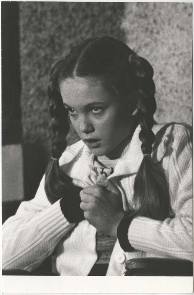
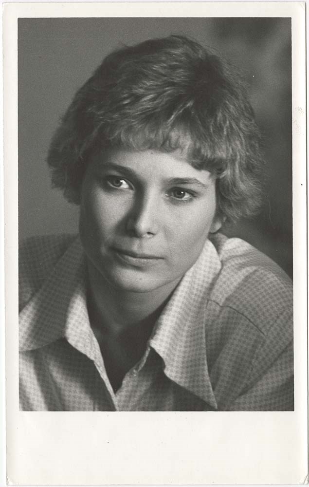
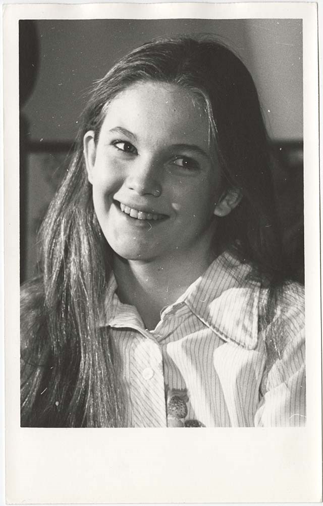
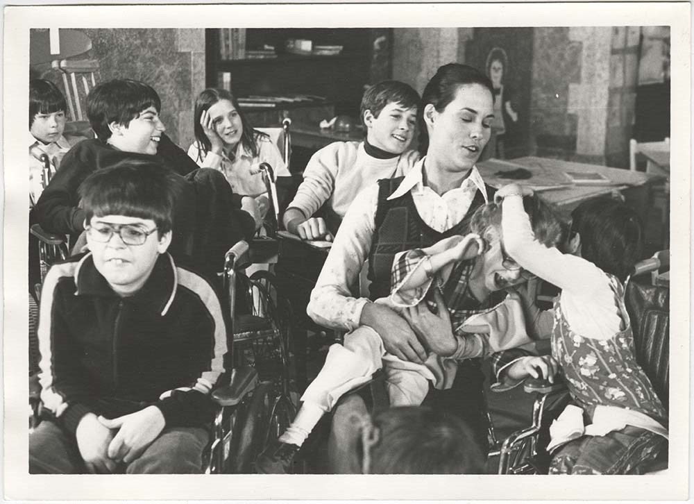
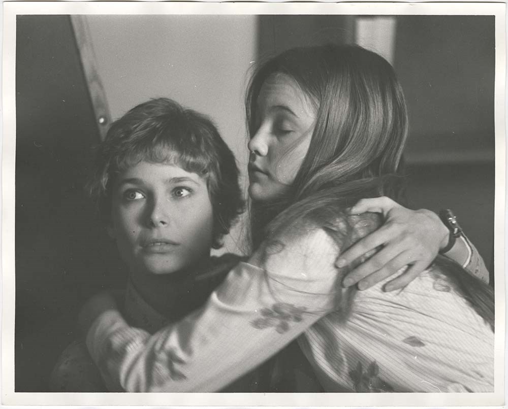
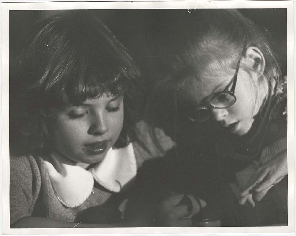
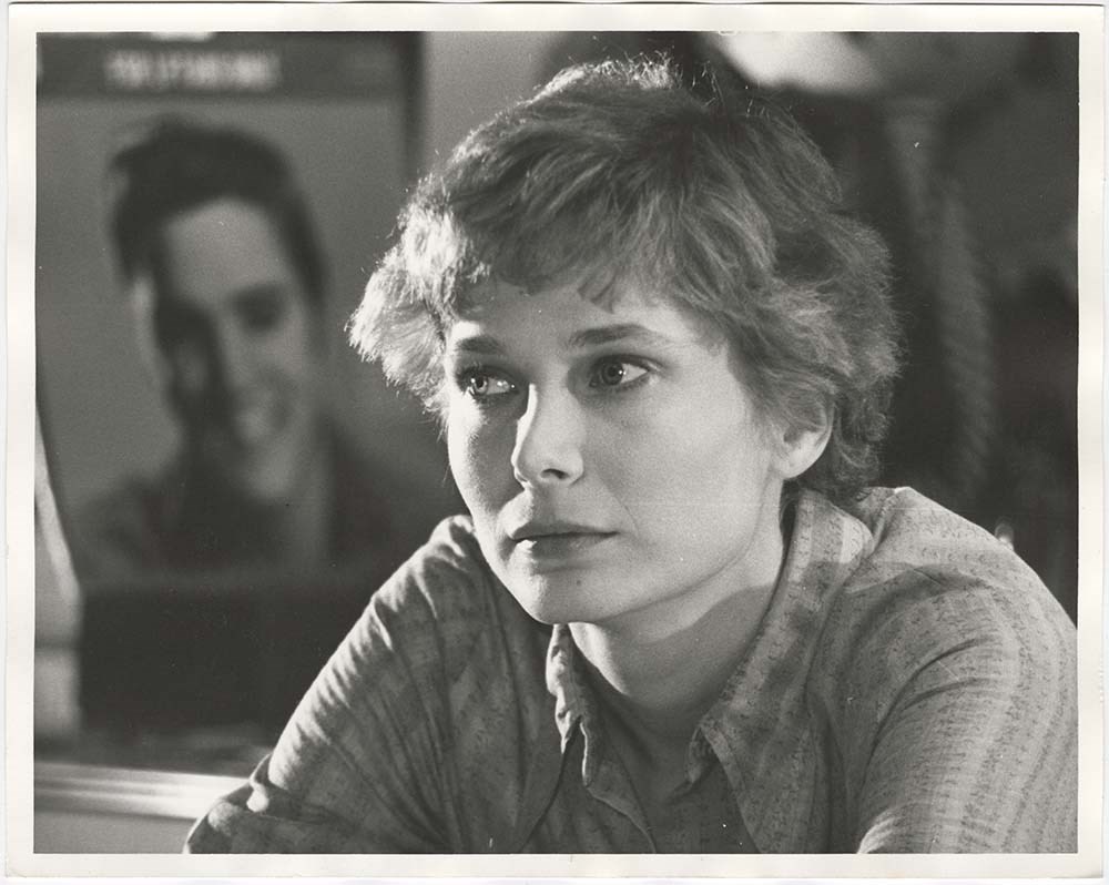
Movie: To Elvis With Love
https://archives.whyte.org/en/permalink/descriptions57211
- Part Of
- Bruno Engler fonds
- Scope & Content
- File pertains to 40 b&w prints of production photos from the shoot of "To Elvis With Love," mostly head-shot style portraits of various actors taken during filming.
- Date Range
- 1979
- Reference Code
- V190 / VI / M / x / f / PA - 01 to PA - 40
- Description Level
- 5 / File
- GMD
- Photograph
9 images
- Part Of
- Bruno Engler fonds
- Description Level
- 5 / File
- Fonds Number
- M323 / S40 / V190
- Series
- VI : Retained file, M : Alphabetical order
- Sous-Fonds
- V190
- Sub-Series
- x : Movies, f : To Elvis With Love
- Accession Number
- 7436
- Reference Code
- V190 / VI / M / x / f / PA - 01 to PA - 40
- GMD
- Photograph
- Date Range
- 1979
- Physical Description
- 39 photographs : b&w & col. ; 25.2 x 20.2 cm or smaller
- History / Biographical
- "To Elvis With Love" also known as "Touched by Love," 1980, directed by Gus Trikonis and starring Deborah Raffin, Diane Lane, Michael Learned, Clu Gulager, and John Amos. Based on a real-life therapist who cared for a wheelchair-bound girl suffering with cerebral-palsy. The young, unresponsive patient is rehabilitated through correspondence with her favourite performer Elvis Presley. Location filming in Banff townsite and vicinity—Banff Springs Golf Course Clubhouse, Banff High School, and Lake Minnewanka road. A number of Banff teenagers were used in the movie as well as a group of special-needs students from Calgary.
- Scope & Content
- File pertains to 40 b&w prints of production photos from the shoot of "To Elvis With Love," mostly head-shot style portraits of various actors taken during filming.
- Subject Access
- Banff Springs Hotel
- Banff townsite
- Buildings
- Children
- Films and film making
- Movie Stars
- Women
- Geographic Access
- Banff
- Banff National Park
- Alberta
- Language
- English
- Related Material
- V190 / VI / M / x / f / NA - 01 to NA - 25
- Creator
- Engler, Bruno
- Biographical Source Notes
- Hollywood in the Canadian Rockies, by Brian Patton, e-book.
- Title Source
- Original title kept
- Processing Status
- Processed
Images


This material is presented as originally created; it may contain outdated cultural descriptions and
potentially offensive content.
Read more.
Jim Murphy fonds
https://archives.whyte.org/en/permalink/descriptions522
- Part Of
- Jim Murphy fonds
- Scope & Content
- Fonds pertains to Bill Peyto cabin at Healy Lakes. Includes views of interior, exterior and surrounding area.
- Date Range
- 1978
- Reference Code
- V451
- Description Level
- 1 / Fonds
- GMD
- Photograph
- Negative
- Photograph print
- Transparency
- Part Of
- Jim Murphy fonds
- Description Level
- 1 / Fonds
- Fonds Number
- V 451
- Sous-Fonds
- V 451
- Accession Number
- 3246
- Reference Code
- V451
- Date Range
- 1978
- Physical Description
- 52 photographs : prints, transparencies, negatives
- History / Biographical
- Jim Murphy was a national park warden at Banff, Alberta, Canada
- Scope & Content
- Fonds pertains to Bill Peyto cabin at Healy Lakes. Includes views of interior, exterior and surrounding area.
- Name Access
- Murphy, Jim
- Peyto, Bill
- Subject Access
- Buildings and facilities
- Cabins and shelters
- Access Restrictions
- No restrictions on access
- Copyright, privacy, commercial use and other restrictions may apply
- Language
- Language is English
- Finding Aid
- Finding aids and reference tools: basic description
- Creator
- Murphy, Jim
- Category
- Family and personal life
- Title Source
- Title based on accession record
- Processing Status
- Processed
This material is presented as originally created; it may contain outdated cultural descriptions and
potentially offensive content.
Read more.
Steve White fonds
https://archives.whyte.org/en/permalink/descriptions567
- Part Of
- Steve White fonds
- Scope & Content
- Fonds pertains to log buildings in Ghost River area; cabin built in 1928 by Jack Rae and Pat Brewster. Photographs by Steve White and Frances Roback.
- Date Range
- 1978
- Reference Code
- V686
- Description Level
- 1 / Fonds
- GMD
- Photograph
- Transparency
- Part Of
- Steve White fonds
- Description Level
- 1 / Fonds
- Fonds Number
- V 686
- Sous-Fonds
- V 686
- Accession Number
- 5379
- Reference Code
- V686
- Date Range
- 1978
- Physical Description
- 14 photographs : transparencies
- Scope & Content
- Fonds pertains to log buildings in Ghost River area; cabin built in 1928 by Jack Rae and Pat Brewster. Photographs by Steve White and Frances Roback.
- Name Access
- Roback, Frances
- White, Steve
- Subject Access
- Buildings and facilities
- Ghost River
- Log structures
- Access Restrictions
- No restrictions on access
- Copyright, privacy, commercial use and other restrictions may apply
- Language
- Language is English
- Creator
- Roback, Frances
- White, Steve
- Category
- Environment
- Title Source
- Title based on accession record
- Processing Status
- Processed
This material is presented as originally created; it may contain outdated cultural descriptions and
potentially offensive content.
Read more.
Topographic map of Blackstone Kale area in the Ogilvie Mountains, Yukon Territory. Blackstone River.
https://archives.whyte.org/en/permalink/catalogue23496
- Medium
- Library - Maps and blueprints (unannotated; published)
- Map
- Published Date
- 1978
- Publisher
- D.E.M.R.
- Call Number
- NTS
- 116H/4
- Publisher
- D.E.M.R.
- Published Date
- 1978
- Scale
- 1: 50,000
- Subjects
- Blackstone Lake
- Yukon Territory
- Accession Number
- 11.500
- Call Number
- NTS
- 116H/4
- Collection
- Archives Library
This material is presented as originally created; it may contain outdated cultural descriptions and
potentially offensive content.
Read more.
[Goodsir, Mount]
https://archives.whyte.org/en/permalink/catalogue23636
- Medium
- Library - Maps and blueprints (unannotated; published)
- Map
- Published Date
- 1978
- Publisher
- Surveys and Mapping Branch, Dept. of Energy, Mines and Resources
- Call Number
- NTS
- 82N/1
- Publisher
- Surveys and Mapping Branch, Dept. of Energy, Mines and Resources
- Published Date
- 1978
- Physical Description
- Colour
- Scale
- Scale: 1:50,000
- Relief: Contour Interval 100 ft.
- Subjects
- Goodsir, Mount
- Notes
- National Topographic System
- Accession Number
- 12,500
- Call Number
- NTS
- 82N/1
- Collection
- Archives Library
This material is presented as originally created; it may contain outdated cultural descriptions and
potentially offensive content.
Read more.
Topographic map, Mount Brimston, Y.T.
https://archives.whyte.org/en/permalink/catalogue23750
- Medium
- Library - Maps and blueprints (unannotated; published)
- Map
- Published Date
- 1978
- Call Number
- NTS
- 116G/11
- Published Date
- 1978
- Scale
- 1:50,000
- Subjects
- Mount Brimston - Y.T.
- Notes
- Nahoni Range (Ogilvie Mountains)
- Accession Number
- 11,500
- Call Number
- NTS
- 116G/11
- Collection
- Archives Library
This material is presented as originally created; it may contain outdated cultural descriptions and
potentially offensive content.
Read more.
Topographic map of the Mount Carter area in the Yukon Territory, Ogilvie Mountains. Blackstone River
https://archives.whyte.org/en/permalink/catalogue23751
- Medium
- Library - Maps and blueprints (unannotated; published)
- Map
- Published Date
- 1978
- Publisher
- D.E.M.R.
- Call Number
- NTS
- 116H/11
- Publisher
- D.E.M.R.
- Published Date
- 1978
- Scale
- 1:50,000
- Subjects
- Mount Carter - Y.T.
- Accession Number
- 11,500
- Call Number
- NTS
- 116H/11
- Collection
- Archives Library
This material is presented as originally created; it may contain outdated cultural descriptions and
potentially offensive content.
Read more.