Narrow Results By
- Murray Hay fonds 20
- Ben Gadd fonds 18
- Nicholas Morant fonds 6
- Trail Riders of the Canadian Rockies fonds 2
- Archives General File Collection 1
- Arnold Wexler fonds 1
- Arthur Oliver Wheeler fonds 1
- Bert Riggall fonds 1
- Bob Hind fonds 1
- Bob Smith fonds 1
- Brewster Transport Company Ltd. fonds 1
- Bruno Engler fonds 1
Deep Powder and Steep Rock - textual
https://archives.whyte.org/en/permalink/descriptions55082
- Part Of
- Chic Scott fonds
- Scope & Content
- Series consists of textual records, including notes, manuscripts and other related materials, pertaining to the creation of the book "Deep Powder and Steep Rock".
- Date Range
- 2009
- Reference Code
- M57 / V
- Description Level
- 3 / Series
- GMD
- Textual record
- Map
- Part Of
- Chic Scott fonds
- Description Level
- 3 / Series
- Fonds Number
- M57 / V40 / S47
- Series
- M57 / V : Deep Powder and Steep Rock
- Sous-Fonds
- M57
- Accession Number
- 2014.8295
- 2015.8559
- Reference Code
- M57 / V
- GMD
- Textual record
- Map
- Date Range
- 2009
- Physical Description
- 30 cm of textual records
- History / Biographical
- Hans Gmoser played a major role in creating Canada’s vibrant mountain community. Although known internationally as the father of heli-skiing, he was much more than that: a talented rock climber, tireless expedition leader, a mountain guide, film maker and organizer. Deep Powder and Steep Rock presents an intimate portrait of this charismatic man. Much of the story is told in Gmoser’s own words, gleaned from his diaries, expedition journals, film commentaries and personal correspondence. It is a unique tale of adventure, hard work, perseverance and ultimate success.
- Scope & Content
- Series consists of textual records, including notes, manuscripts and other related materials, pertaining to the creation of the book "Deep Powder and Steep Rock".
- Notes
- Series consists of five sub-series: M57 / V / A: Research files M57 / V / B: Maps M57 / V / C: Interviews M57 / V / D: Photograph notes M57 / V / E: Draft Manuscript
- Name Access
- Scott, Chic
- Gmoser, Hans
- Subject Access
- Biography
- Personal and Professional Life
- Publication
- Research
- Geography
- Map
- Mountaineers
- Mountaineering
- Skiing
- Sports
- Recreation
- Winter sports
- Canadian Mountain Holidays
- Helicopter skiing
- Tourism
- Climbing
- Geographic Access
- Canada
- Alberta
- Banff
- Banff National Park
- Canadian Rocky Mountains
- Language
- English
- Related Material
- S47 / V
- V40 / V
- Biographical Source Notes
- http://chicscott.com/books.htm
- Title Source
- Title based on contents of file
- Processing Status
- Processed
This material is presented as originally created; it may contain outdated cultural descriptions and
potentially offensive content.
Read more.
Camp coordinator packages, notes and handouts
https://archives.whyte.org/en/permalink/descriptions54472
- Scope & Content
- File consists of introductory packages put together for Camp Coordinators on pack trips led by the Trail Riders of the Canadian Rockies in 2008. File includes contact lists, name lists and basic information about riders, participant reports, printed maps and brochures pertaining to specific packing…
- Date Range
- 2008
- Reference Code
- M545 / II / 14
- Description Level
- 5 / File
- GMD
- Textual record
- Organization record
- Map
- Postcard
- Description Level
- 5 / File
- Fonds Number
- M545 / V635
- Series
- M545 / II : Members, Staff, Personal Content
- Sous-Fonds
- M545
- Accession Number
- 8235
- Reference Code
- M545 / II / 14
- Date Range
- 2008
- Physical Description
- 1.5 cm of textual records
- Scope & Content
- File consists of introductory packages put together for Camp Coordinators on pack trips led by the Trail Riders of the Canadian Rockies in 2008. File includes contact lists, name lists and basic information about riders, participant reports, printed maps and brochures pertaining to specific packing trips in 2008, blank survey sheets and insurance waivers, and itineraries. Items are kept in order of 2008 ride numbers: Ride 1, Ride 2, etc.
- Notes
- Contains numerous duplicates
- Subject Access
- Administration
- Packing
- Travel
- Tourism
- Geography
- Geographic Access
- Canada
- Alberta
- Kananaskis
- Banff
- Access Restrictions
- Restrictions may apply due to personal information
- Reproduction Restrictions
- Restrictions may apply due to personal information
- Language
- English
- Category
- Sports, recreation and leisure
- Title Source
- Title based on contents of file
- Processing Status
- Processed
This material is presented as originally created; it may contain outdated cultural descriptions and
potentially offensive content.
Read more.
[Hightower Creek - Alberta]
https://archives.whyte.org/en/permalink/catalogue23660
- Medium
- Library - Maps and blueprints (unannotated; published)
- Map
- Published Date
- 1949
- Publisher
- Dept. of Mines & Technical Surv.
- Call Number
- NTS
- 83F/13E
- Publisher
- Dept. of Mines & Technical Surv.
- Published Date
- 1949
- Scale
- 1:50,000
- Subjects
- Hightower Creek - Alberta
- Notes
- National Topographic System
- Accession Number
- 12000
- Call Number
- NTS
- 83F/13E
- Collection
- Archives Library
This material is presented as originally created; it may contain outdated cultural descriptions and
potentially offensive content.
Read more.
[Hightower Creek - Alberta]
https://archives.whyte.org/en/permalink/catalogue23661
- Medium
- Library - Maps and blueprints (unannotated; published)
- Map
- Published Date
- 1949
- Publisher
- Dept. of Mines & Technical Survey
- Call Number
- NTS
- 83F/13W
- Publisher
- Dept. of Mines & Technical Survey
- Published Date
- 1949
- Scale
- 1:50,000
- Subjects
- Hightower Creek - Alberta
- Notes
- National Topographic System
- Accession Number
- 12000
- Call Number
- NTS
- 83F/13W
- Collection
- Archives Library
This material is presented as originally created; it may contain outdated cultural descriptions and
potentially offensive content.
Read more.
Topographical Map
https://archives.whyte.org/en/permalink/catalogue24619
- Medium
- Library - Maps and blueprints (unannotated; published)
- Map
- Published Date
- 1948
- Publisher
- Dept. of Mines and Resources
- Call Number
- C3-2.4
- Publisher
- Dept. of Mines and Resources
- Published Date
- 1948
- Physical Description
- Colour
- Scale
- Scale: 1:63,360
- Relief: Contour interval 100'
- Subjects
- Lake Louise
- Accession Number
- 1105
- Call Number
- C3-2.4
- Collection
- Archives Library
This material is presented as originally created; it may contain outdated cultural descriptions and
potentially offensive content.
Read more.
Province of Alberta
https://archives.whyte.org/en/permalink/catalogue24409
- Medium
- Library - Maps and blueprints (unannotated; published)
- Map
- Published Date
- 1947
- Publisher
- Alberta Dept. of Lands and Mines
- Call Number
- C9-1.19
- Publisher
- Alberta Dept. of Lands and Mines
- Published Date
- 1947
- Physical Description
- 1 map
- Scale
- Scale: 1 inch = 16 miles
- Subjects
- Alberta
- Notes
- In oversize cabinet (rolled up)
- Accession Number
- 6406
- Call Number
- C9-1.19
- Collection
- Archives Library
This material is presented as originally created; it may contain outdated cultural descriptions and
potentially offensive content.
Read more.
Topographic Map
https://archives.whyte.org/en/permalink/catalogue24621
- Medium
- Library - Maps and blueprints (unannotated; published)
- Map
- Published Date
- 1947
- Publisher
- Dept. of Mines and Resources
- Call Number
- C3-3.1
- Publisher
- Dept. of Mines and Resources
- Published Date
- 1947
- Physical Description
- Colour
- Scale
- Scale: 1": 1 mile
- Relief: Contour interval 100'
- Subjects
- Sunwapta
- Accession Number
- 442
- Call Number
- C3-3.1
- Collection
- Archives Library
This material is presented as originally created; it may contain outdated cultural descriptions and
potentially offensive content.
Read more.
Jasper Park South Sheet
https://archives.whyte.org/en/permalink/catalogue23180
- Medium
- Library - Maps and blueprints (unannotated; published)
- Map
- Published Date
- 1947
- Publisher
- Dept. of Mines and Resources
- Call Number
- C2-2.7
- Publisher
- Dept. of Mines and Resources
- Published Date
- 1947
- Scale
- Scale: 3 miles to 1 inch
- Notes
- Relief: Contour Interval 200'
- Accession Number
- 400, 718
- Call Number
- C2-2.7
- Collection
- Archives Library
This material is presented as originally created; it may contain outdated cultural descriptions and
potentially offensive content.
Read more.
[Jasper Park]
https://archives.whyte.org/en/permalink/catalogue23181
- Medium
- Library - Maps and blueprints (unannotated; published)
- Map
- Published Date
- 1947
- Publisher
- Dept. of Mines and Technical Surveys
- Call Number
- C2-2.8
- Publisher
- Dept. of Mines and Technical Surveys
- Published Date
- 1947
- Physical Description
- 1 map : col
- Scale
- Scale: 1 inch : 3 miles
- Relief: Contour Interval 200 ft
- Subjects
- Jasper National Park
- Notes
- Dup. in Research Room/2 Dup. in Map Room
- Accession Number
- 3000
- 673
- 1153 M. 171
- 1096
- 3349
- Call Number
- C2-2.8
- Collection
- Archives Library
This material is presented as originally created; it may contain outdated cultural descriptions and
potentially offensive content.
Read more.
[Jasper Park (South Sheet)]
https://archives.whyte.org/en/permalink/catalogue23182
- Medium
- Library - Maps and blueprints (unannotated; published)
- Map
- Published Date
- 1947 (interim corrections 1974)
- Publisher
- Department of Mines and Technical Surveys
- Call Number
- C2-2.8 (a)
- Publisher
- Department of Mines and Technical Surveys
- Published Date
- 1947 (interim corrections 1974)
- Physical Description
- 1 map : col
- Scale
- Scale: I inch: 3 miles
- Relief: Counter interval 200 ft.
- Subjects
- Jasper National Park
- Accession Number
- 7000
- Call Number
- C2-2.8 (a)
- Collection
- Archives Library
This material is presented as originally created; it may contain outdated cultural descriptions and
potentially offensive content.
Read more.
[Deep Valley Creek South, Alberta]
https://archives.whyte.org/en/permalink/catalogue23579
- Medium
- Library - Maps and blueprints (unannotated; published)
- Map
- Published Date
- 1947
- Publisher
- Dept. of Mines & Technical Survey
- Call Number
- NTS
- 82K/4E
- Publisher
- Dept. of Mines & Technical Survey
- Published Date
- 1947
- Scale
- Scale: 1:50,000
- Subjects
- Deep Valley Creek
- Alberta
- Notes
- National Topographic System
- Accession Number
- 12000
- Call Number
- NTS
- 82K/4E
- Collection
- Archives Library
This material is presented as originally created; it may contain outdated cultural descriptions and
potentially offensive content.
Read more.
[Deep Valley Creek South, Alberta]
https://archives.whyte.org/en/permalink/catalogue23580
- Medium
- Library - Maps and blueprints (unannotated; published)
- Map
- Published Date
- 1947
- Publisher
- Dept. of Mines & Technical Survey
- Call Number
- NTS
- 83K/4W
- Publisher
- Dept. of Mines & Technical Survey
- Published Date
- 1947
- Scale
- Scale: 1:50,000
- Subjects
- Deep Valley Creek
- Alberta
- Notes
- National Topographic System
- Accession Number
- 12000
- Call Number
- NTS
- 83K/4W
- Collection
- Archives Library
This material is presented as originally created; it may contain outdated cultural descriptions and
potentially offensive content.
Read more.
[United States]
https://archives.whyte.org/en/permalink/catalogue24812
- Medium
- Library - Maps and blueprints (unannotated; published)
- Map
- Published Date
- 1946
- Publisher
- National Geographic Society
- Call Number
- C13-1.1(d)
- Publisher
- National Geographic Society
- Published Date
- 1946
- Scale
- Scale: 78.91 miles to 1 inch
- Relief: Bench marks
- Subjects
- United States
- Accession Number
- 495
- Call Number
- C13-1.1(d)
- Collection
- Archives Library
This material is presented as originally created; it may contain outdated cultural descriptions and
potentially offensive content.
Read more.
[RECONNAISSANCE PLAN: BANFF_MT. ASSINIBOINE PARK ROUTE 4 via Healy Creek, Sunshine Lodge, Citadel Pass]
https://archives.whyte.org/en/permalink/catalogue24909
- Medium
- Library - Maps and blueprints (unannotated; published)
- Map
- Published Date
- 1946 (transfered to manuscript Oct. 1994)
- Call Number
- C2-10.1 (d)
- Published Date
- 1946 (transfered to manuscript Oct. 1994)
- Scale
- 1) Scale: 4 ": 1 mile
- Relief - Counter interval 50 ft.
- 2) Scale: 1 ": 200 ft.
- Relief - Counter interval: 5 ft.
- Subjects
- Mount Assiniboine Provincial Park
- Notes
- 2) = Plan of Healy Creek_Mt. Assiniboine Proposed Location Class "C" Highway Survey 1946/Section 1_Banff to Healy Creek
- 5) Sunshine to Quartz Hill
- 6) 3 sections
- Accession Number
- 2158
- Call Number
- C2-10.1 (d)
- Collection
- Archives Library
This material is presented as originally created; it may contain outdated cultural descriptions and
potentially offensive content.
Read more.
Map showing Coalfields, Potential Coal Areas and Coal occurences of Canada
https://archives.whyte.org/en/permalink/catalogue21472
- Medium
- Library - Book (including soft-cover and pamphlets)
- Map
- Published Date
- 1946
- Publisher
- Dept. of Mines and Resources
- Call Number
- C7-5.7
- Publisher
- Dept. of Mines and Resources
- Published Date
- 1946
- Subjects
- Canada - Coal Areas
- Accession Number
- 3071
- Call Number
- C7-5.7
- Collection
- Archives Library
This material is presented as originally created; it may contain outdated cultural descriptions and
potentially offensive content.
Read more.
Glacier Park, B.C.
https://archives.whyte.org/en/permalink/catalogue23225
- Medium
- Library - Maps and blueprints (unannotated; published)
- Map
- Published Date
- 1946
- Publisher
- Ottawa, Tophographical Survey of Canada
- Call Number
- C2-7.5a
- Publisher
- Ottawa, Tophographical Survey of Canada
- Published Date
- 1946
- Physical Description
- 1 map : col
- Scale
- Scale: 1:126,720
- Subjects
- Glacier National Park
- Accession Number
- 3349
- Call Number
- C2-7.5a
- Collection
- Archives Library
This material is presented as originally created; it may contain outdated cultural descriptions and
potentially offensive content.
Read more.
[Blairmore 82G/9 West, Alberta]
https://archives.whyte.org/en/permalink/catalogue23501
- Medium
- Library - Maps and blueprints (unannotated; published)
- Map
- Published Date
- 1946
- Publisher
- Dept. of Mines and Techinical Surveys
- Call Number
- NTS
- 82G/9W
- Publisher
- Dept. of Mines and Techinical Surveys
- Published Date
- 1946
- Physical Description
- 1 map : col
- Scale
- Scale: 1:50,000
- Relief: Contour interval 100'
- Subjects
- Blairmore
- Western Alberta
- Notes
- National Topographic System
- Call Number
- NTS
- 82G/9W
- Collection
- Archives Library
This material is presented as originally created; it may contain outdated cultural descriptions and
potentially offensive content.
Read more.
[Moberly Creek - Alberta]
https://archives.whyte.org/en/permalink/catalogue23741
- Medium
- Library - Maps and blueprints (unannotated; published)
- Map
- Published Date
- 1946
- Publisher
- Dept. of Mines & Technical Surveys
- Call Number
- NTS
- 83E/9
- Publisher
- Dept. of Mines & Technical Surveys
- Published Date
- 1946
- Scale
- 1:50,000
- Subjects
- Moberly Creek - Alberta
- Notes
- National Topographic System
- Provisional Map
- Accession Number
- 12000
- Call Number
- NTS
- 83E/9
- Collection
- Archives Library
This material is presented as originally created; it may contain outdated cultural descriptions and
potentially offensive content.
Read more.
[Waterton Lakes Park]
https://archives.whyte.org/en/permalink/catalogue23214
- Medium
- Library - Maps and blueprints (unannotated; published)
- Map
- Published Date
- 1945
- Publisher
- Dept. of Mines and Resources
- Call Number
- C2-6.4
- Publisher
- Dept. of Mines and Resources
- Published Date
- 1945
- Physical Description
- 1 map : col
- Scale
- Scale: 1 inch : 1 mile
- Contour Interval 100 ft.
- Subjects
- Waterton Lakes National Park
- Notes
- 1 duplicate - Accn. 2781
- Accession Number
- 718
- 2781
- Call Number
- C2-6.4
- Collection
- Archives Library
This material is presented as originally created; it may contain outdated cultural descriptions and
potentially offensive content.
Read more.
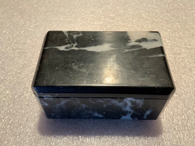
- Date
- 1945 – 1945
- Material
- stone
- Catalogue Number
- 102.04.0201
- Description
- A hand-carved, well-made, lidded box carved from soft Rocky Mountain marble. The box has a front and a back. The front has bevelled corners, whereas the back has square corners. The box interior has rounded corners and the lid fits smoothly and flushly into the cutout. Base is felted with green fel…
1 image
- Title
- Trinket Box
- Date
- 1945 – 1945
- Material
- stone
- Dimensions
- 4.3 x 5.7 x 9.2 cm
- Description
- A hand-carved, well-made, lidded box carved from soft Rocky Mountain marble. The box has a front and a back. The front has bevelled corners, whereas the back has square corners. The box interior has rounded corners and the lid fits smoothly and flushly into the cutout. Base is felted with green felt. The marble is black, streaked with white.
- Credit
- Gift of Catharine Robb Whyte, O. C., Banff, 1979
- Catalogue Number
- 102.04.0201
Images
This material is presented as originally created; it may contain outdated cultural descriptions and
potentially offensive content.
Read more.