Narrow Results By
Map of North America engraved to illustrate Mitchell's school and family geography
https://archives.whyte.org/en/permalink/catalogue24834
- Medium
- Library - Maps and blueprints (unannotated; published)
- Map
- Published Date
- 1852
- Publisher
- Pennsylvania : S. Augustus Mitchell
- Call Number
- C13.4.6
- Publisher
- Pennsylvania : S. Augustus Mitchell
- Published Date
- 1852
- Physical Description
- 1 map : col
- Scale
- 1 inch = ca 600 miles
- Subjects
- North America
- Hooker, Mount
- Brown, Mount
- Notes
- Map shows Mts. Hooker and Brown, and gives altitudes of same
- Accession Number
- 3612
- Call Number
- C13.4.6
- Collection
- Archives Library
This material is presented as originally created; it may contain outdated cultural descriptions and
potentially offensive content.
Read more.
- Date
- 1850 – 1900
- Material
- wood
- Catalogue Number
- 102.04.0200
- Description
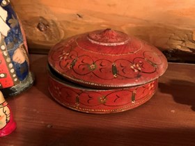
- A lathe-turned round-dish, flat-bottomed box with a domed, lapping lid which fits flushly over a flange on the box body. Box and lid are painted a boxcar red and decorated with designs of circles and flowers, varnish over paint has oxidized. Interior of box has been painted a dark green.
1 image
- Title
- Trinket Box
- Date
- 1850 – 1900
- Material
- wood
- Dimensions
- 6.3 x 13.0 cm
- Description
- A lathe-turned round-dish, flat-bottomed box with a domed, lapping lid which fits flushly over a flange on the box body. Box and lid are painted a boxcar red and decorated with designs of circles and flowers, varnish over paint has oxidized. Interior of box has been painted a dark green.
- Subject
- households
- decorative
- Credit
- Gift of Catharine Robb Whyte, O. C., Banff, 1979
- Catalogue Number
- 102.04.0200
Images
This material is presented as originally created; it may contain outdated cultural descriptions and
potentially offensive content.
Read more.


