Narrow Results By
- Boorne and May fonds 102
- Vaux family fonds 45
- Mary Schaffer fonds 42
- Moore family fonds 23
- Alpine Club of Canada fonds 6
- Luxton family fonds 6
- Archives General File Collection 5
- Peter and Catharine Whyte fonds 5
- Nicholas Morant fonds 4
- Dorothy Cranstone fonds 3
- Jim Brewster family fonds 3
- Charles Reid fonds 2
- Boorne & May Photographers (Calgary, NWT) 100
- Vaux family (Philadelphia USA) 24
- Mary M. Vaux (Philadelphia USA) 10
- Alpine Club of Canada 6
- Mary Schaffer (Philadelphia, USA) - attributed to 6
- [Mary Schaffer] 4
- Adams, Molly 3
- Boorne and May 3
- Cranstone, Dorothy 3
- McDougall, David 3
- McLean, George 3
- Schaffer, Mary 3
July and August Album
https://archives.whyte.org/en/permalink/descriptions57669
- Part Of
- Alpine Club of Canada fonds
- Scope & Content
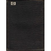
- Item consists of 1 photograph album compiled by Frank W. Freeborn of New York City for the Alpine Club of Canada. The album pertains to a 1909 ACC trip in and around Lake Louise, Banff, Lake O'Hara, and Field, as well as the Mt. Hood area of Oregon, and includes black and white photographs, all of …
- Date Range
- 1909
- Reference Code
- V14 / AC 55P / PD - 5
- Description Level
- 6 / Item
- GMD
- Album
- Photograph
1 image
1 Electronic Resource
- Part Of
- Alpine Club of Canada fonds
- Description Level
- 6 / Item
- Fonds Number
- M200 / S6 / V14
- Series
- IV.B. Other material: photographic
- Sous-Fonds
- V14
- Accession Number
- 5200
- Reference Code
- V14 / AC 55P / PD - 5
- GMD
- Album
- Photograph
- Date Range
- 1909
- Physical Description
- 1 album (194 photographs : b&w and col. ; 20.3 x 25.5 cm)
- Scope & Content
- Item consists of 1 photograph album compiled by Frank W. Freeborn of New York City for the Alpine Club of Canada. The album pertains to a 1909 ACC trip in and around Lake Louise, Banff, Lake O'Hara, and Field, as well as the Mt. Hood area of Oregon, and includes black and white photographs, all of which are annotated in white ink. A small white paper with "G" printed on it is adhered to the top left corner of the front cover and "1909" is written in white ink in the middle of the front cover.
- Name Access
- Alpine Club of Canada
- Subject Access
- Activities
- Alpine Club of Canada
- Animals
- Backpacking
- Bow Falls
- Bow River
- Bow Valley
- Buildings
- Camps
- Canadian Pacific Railway
- Chateau Lake Louise
- Climbing
- Clothing and dress
- Club
- Environment and Nature
- Glaciers
- Hiking
- Hotels
- Lake Louise
- Lake O'hara
- Landscapes
- Mountaineering
- Mountaineers
- Mountains
- Period costume
- Photography
- Portrait
- Railways
- Scenery
- scenic
- Trails
- Trains
- Transportation
- Geographic Access
- Lake Louise
- Banff National Park
- Alberta
- Field
- Yoho National Park
- Oregon
- Language
- English
- Finding Aid
- Inventory of the Alpine Club of Canada Collection, 1986, provides group or item-level description to this material
- Title Source
- Title based on item
- Processing Status
- Processed
Electronic Resources
Images

This material is presented as originally created; it may contain outdated cultural descriptions and
potentially offensive content.
Read more.
Sectional map
https://archives.whyte.org/en/permalink/catalogue24461
- Medium
- Library - Maps and blueprints (unannotated; published)
- Map
- Published Date
- 1909
- Publisher
- Dept. of the Interior, Ottawa
- Call Number
- C9-6.1
- Publisher
- Dept. of the Interior, Ottawa
- Published Date
- 1909
- Scale
- 6 miles: 1 inch
- Subjects
- Pincher Creek Sheet
- Accession Number
- 400
- Call Number
- C9-6.1
- Collection
- Archives Library
This material is presented as originally created; it may contain outdated cultural descriptions and
potentially offensive content.
Read more.
Sectional map
https://archives.whyte.org/en/permalink/catalogue24462
- Medium
- Library - Maps and blueprints (unannotated; published)
- Map
- Published Date
- 1909
- Publisher
- Dept. of the Interior, Ottawa
- Call Number
- C9-6.2
- Publisher
- Dept. of the Interior, Ottawa
- Published Date
- 1909
- Scale
- 6 miles: 1 inch
- Subjects
- Lethbridge Sheet
- Accession Number
- 400
- Call Number
- C9-6.2
- Collection
- Archives Library
This material is presented as originally created; it may contain outdated cultural descriptions and
potentially offensive content.
Read more.
Sectional Map, Special Edition showing Lands disposed of
https://archives.whyte.org/en/permalink/catalogue24589
- Medium
- Library - Maps and blueprints (unannotated; published)
- Map
- Published Date
- 1909
- Call Number
- C11-6.12
- Published Date
- 1909
- Scale
- 6 miles - 1 inch
- Notes
- References: Trails, Trails surveyed, Post Offices, Railway Stations, Range numbers, Township numbers......
- Accession Number
- 400
- Call Number
- C11-6.12
- Collection
- Archives Library
This material is presented as originally created; it may contain outdated cultural descriptions and
potentially offensive content.
Read more.
CPR Plan and Profile of Line Change, Rogers Pass
https://archives.whyte.org/en/permalink/catalogue24796
- Medium
- Library - Maps and blueprints (unannotated; published)
- Map
- Published Date
- 1909
- Call Number
- C12-1.28
- Published Date
- 1909
- Scale
- 400 feet to the inch
- Subjects
- Rogers Pass
- Notes
- Photostatic copy from the B.C. Provincial Archives
- Accession Number
- 2353
- Call Number
- C12-1.28
- Collection
- Archives Library
This material is presented as originally created; it may contain outdated cultural descriptions and
potentially offensive content.
Read more.
1908 Calgary Exhibition souvenir album
https://archives.whyte.org/en/permalink/descriptions55236
- Part Of
- Malcolm Geddes fonds
- Scope & Content
- File consists of one souvenir album pertaining to the Calgary Exhibition held in 1908. Album contains 28 b&w photographs which depict staff involved with the exhibition, views of exhibition grounds, a parade, and other related subjects.
- Date Range
- 1908
- Reference Code
- V756 / III / C / PD - 1
- Description Level
- 5 / File
- GMD
- Album
- Photograph
- Photograph print
- Part Of
- Malcolm Geddes fonds
- Description Level
- 5 / File
- Fonds Number
- M39
- V756
- Series
- V756 / III : Personal and family records
- Sous-Fonds
- V756
- Sub-Series
- V756 / III / C : Other personal and family records
- Accession Number
- 2015.8558
- Reference Code
- V756 / III / C / PD - 1
- Date Range
- 1908
- Physical Description
- 1 album (28 photographs : b&w ; 28 x 20 cm or smaller)
- Scope & Content
- File consists of one souvenir album pertaining to the Calgary Exhibition held in 1908. Album contains 28 b&w photographs which depict staff involved with the exhibition, views of exhibition grounds, a parade, and other related subjects.
- Subject Access
- Activities
- Community events
- Events
- Horses
- Leisure
- Public events
- Recreation
- Souvenir
- Tourism
- Geographic Access
- Canada
- Alberta
- Calgary
- Language
- English
- Conservation
- Item has been interleaved
- Category
- Sports, recreation and leisure
- Title Source
- Title based on contents of file
- Processing Status
- Processed
This material is presented as originally created; it may contain outdated cultural descriptions and
potentially offensive content.
Read more.
Papaschase Indian Reserve land zoning map
https://archives.whyte.org/en/permalink/descriptions55611
- Part Of
- Luxton family fonds
- Scope & Content
- File consists of one zoning map depicting the Papaschase Indian Reserve south of the Saskatchewan River and surrounding area. Map is titled "Plan of Township 52 Range 24 West of the Fourth Meridian".
- Date Range
- 1908
- Reference Code
- LUX / III / C2 / 22
- Description Level
- 5 / File
- GMD
- Map
- Part Of
- Luxton family fonds
- Description Level
- 5 / File
- Fonds Number
- LUX
- Series
- LUX / III / C : Extended family
- Sous-Fonds
- LUX / III : Luxton family sous-fonds
- Sub-Series
- LUX / III / C2 : McDougall and Ross families papers and photographs
- Accession Number
- LUX
- Reference Code
- LUX / III / C2 / 22
- GMD
- Map
- Responsibility
- Produced by the Canadian Department of the Interior
- Date Range
- 1908
- Physical Description
- 1 map : b&w photozincograph print ; 34 x 41 cm
- Scope & Content
- File consists of one zoning map depicting the Papaschase Indian Reserve south of the Saskatchewan River and surrounding area. Map is titled "Plan of Township 52 Range 24 West of the Fourth Meridian".
- Geographic Access
- Canada
- Alberta
- Saskatchewan River
- Edmonton
- Access Restrictions
- Fragile material - handle with caution
- Language
- English
- Title Source
- Title based on contents of file
- Processing Status
- Processed
This material is presented as originally created; it may contain outdated cultural descriptions and
potentially offensive content.
Read more.
Canadian Mountains Album
https://archives.whyte.org/en/permalink/descriptions57661
- Part Of
- Alpine Club of Canada fonds
- Scope & Content
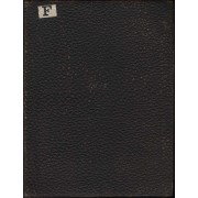
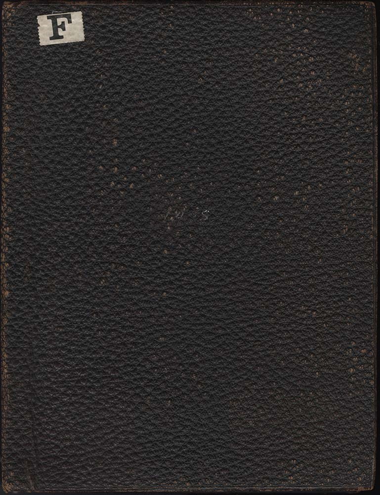
- Item consists of 1 photograph album compiled by Frank W. Freeborn of New York City for the Alpine Club of Canada. The album pertains to a 1908 ACC trip in and around the Lake Louise & Field, BC, areas and includes black and white photographs, all of which are annotated in white ink. A small white p…
- Date Range
- 1908
- Reference Code
- V14 / AC 55P / PD - 4
- Description Level
- 6 / Item
- GMD
- Album
- Photograph
1 image
1 Electronic Resource
- Part Of
- Alpine Club of Canada fonds
- Description Level
- 6 / Item
- Fonds Number
- M200 / S6 / V14
- Series
- IV.B. Other material: photographic
- Sous-Fonds
- V14
- Accession Number
- 5200
- Reference Code
- V14 / AC 55P / PD - 4
- GMD
- Album
- Photograph
- Date Range
- 1908
- Physical Description
- 1 album (159 photographs : b&w and col. ; 20.3 x 25.5 cm)
- Scope & Content
- Item consists of 1 photograph album compiled by Frank W. Freeborn of New York City for the Alpine Club of Canada. The album pertains to a 1908 ACC trip in and around the Lake Louise & Field, BC, areas and includes black and white photographs, all of which are annotated in white ink. A small white paper with "F" printed on it is adhered to the top left corner of the front cover and "1908" is written in white ink on the spine.
- Name Access
- Alpine Club of Canada
- Subject Access
- Activities
- Alpine Club of Canada
- Animals
- Backpacking
- Bears
- Bow Falls
- Bow River
- Bow Valley
- Buildings
- Camps
- Canadian Pacific Railway
- Chateau Lake Louise
- Climbing
- Clothing and dress
- Club
- Environment and Nature
- Glaciers
- Hiking
- Hotels
- Lake Louise
- Landscapes
- Mountaineering
- Mountaineers
- Mountains
- Period costume
- Photography
- Portrait
- Railways
- Scenery
- scenic
- Trails
- Trains
- Transportation
- Geographic Access
- Lake Louise
- Banff National Park
- Alberta
- Field
- Emerald Lake
- Yoho National Park
- British Columbia
- Ottawa
- Ontario
- Language
- English
- Finding Aid
- Inventory of the Alpine Club of Canada Collection, 1986, provides group or item-level description to this material
- Title Source
- Title based on item
- Processing Status
- Processed
Electronic Resources
Images
This material is presented as originally created; it may contain outdated cultural descriptions and
potentially offensive content.
Read more.
Sampson's Map '08
https://archives.whyte.org/en/permalink/descriptions38042
- Part Of
- Mary Schaffer fonds
- Scope & Content
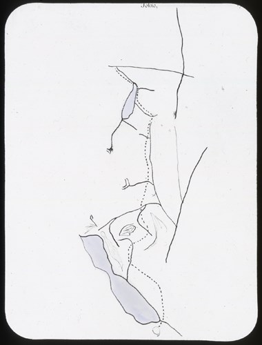
- Sampson Beaver's map, 1908
- Date Range
- 1908
- Reference Code
- V527 / PS 1 - 53
- Description Level
- 6 / Item
- GMD
- Photograph
- Lantern slide
- Transparency
1 image
- Part Of
- Mary Schaffer fonds
- Description Level
- 6 / Item
- Fonds Number
- .
- Series
- II. Photography series
- Sous-Fonds
- .
- Sub-Series
- A. Lantern slides 1. Travels to Maligne Lake and Yellowhead area
- Reference Code
- V527 / PS 1 - 53
- Date Range
- 1908
- Physical Description
- 1 transparency : lantern slide
- Scope & Content
- Sampson Beaver's map, 1908
- Subject Access
- Discovery and Exploration
- First nations
- Geographic Access
- Alberta
- Processing Status
- Processed
Images
This material is presented as originally created; it may contain outdated cultural descriptions and
potentially offensive content.
Read more.
Morley sheet special edition shewing lands disposed of to Mar. 15th, 1908
https://archives.whyte.org/en/permalink/catalogue21410
- Medium
- Library - Maps and blueprints (unannotated; published)
- Map
- Published Date
- 1908
- Publisher
- Dept. of the Interior
- Edition
- special edition
- Call Number
- C9-7.8
- Edition
- special edition
- Publisher
- Dept. of the Interior
- Published Date
- 1908
- Subjects
- Morley
- Notes
- photostatic copy from P.A.C.
- Accession Number
- 675
- Call Number
- C9-7.8
- Collection
- Archives Library
This material is presented as originally created; it may contain outdated cultural descriptions and
potentially offensive content.
Read more.
A special map showing townsite and area surrounding area of Rossland, B.C.
https://archives.whyte.org/en/permalink/catalogue23291
- Medium
- Library - Maps and blueprints (unannotated; published)
- Map
- Published Date
- 1908
- Publisher
- Dept. of the Interior
- Call Number
- C4-5.1
- Publisher
- Dept. of the Interior
- Published Date
- 1908
- Scale
- Relief: Contour interval 20'
- Subjects
- Rossland, BC
- Accession Number
- 400
- Call Number
- C4-5.1
- Collection
- Archives Library
This material is presented as originally created; it may contain outdated cultural descriptions and
potentially offensive content.
Read more.
Sectional map
https://archives.whyte.org/en/permalink/catalogue24463
- Medium
- Library - Maps and blueprints (unannotated; published)
- Map
- Published Date
- 1908
- Publisher
- Dept. of the Interior, Ottawa
- Call Number
- C9-6.3
- Publisher
- Dept. of the Interior, Ottawa
- Published Date
- 1908
- Scale
- 6 miles: 1 inch
- Subjects
- Porcupine Sheet
- Accession Number
- 400
- Call Number
- C9-6.3
- Collection
- Archives Library
This material is presented as originally created; it may contain outdated cultural descriptions and
potentially offensive content.
Read more.
Special edition map showing lands disposed of
https://archives.whyte.org/en/permalink/catalogue24586
- Medium
- Library - Maps and blueprints (unannotated; published)
- Map
- Published Date
- 1908
- Publisher
- Dept. of the Interior
- Call Number
- C11-6.9
- Publisher
- Dept. of the Interior
- Published Date
- 1908
- Scale
- 6 miles - 1 inch
- Subjects
- Canada - Prairie Region
- Manitoba
- Notes
- Sectional map
- References: Trails, Trails surveyed, Post Offices, Railway Stations, Range Numbers, Township numbers.....
- Accession Number
- 400
- Call Number
- C11-6.9
- Collection
- Archives Library
This material is presented as originally created; it may contain outdated cultural descriptions and
potentially offensive content.
Read more.
Special edition map showing lands disposed of
https://archives.whyte.org/en/permalink/catalogue24587
- Medium
- Library - Maps and blueprints (unannotated; published)
- Map
- Published Date
- 1908
- Publisher
- Dept. of the Interior
- Call Number
- C11-6.10
- Publisher
- Dept. of the Interior
- Published Date
- 1908
- Scale
- 6 miles - 1 inch
- Notes
- Sectional map
- References: Trails, Trails surveyed, Post Offices, Railway Stations, Range numbers, Township numbers...
- Accession Number
- 400
- Call Number
- C11-6.10
- Collection
- Archives Library
This material is presented as originally created; it may contain outdated cultural descriptions and
potentially offensive content.
Read more.
Special edition map showing lands disposed of
https://archives.whyte.org/en/permalink/catalogue24588
- Medium
- Library - Maps and blueprints (unannotated; published)
- Map
- Published Date
- 1908
- Publisher
- Dept. of the Interior
- Call Number
- C11-6.11
- Publisher
- Dept. of the Interior
- Published Date
- 1908
- Scale
- 6 miles - 1 inch
- Notes
- Sectional map
- References: Trails, Trails surveyed, Post Offices, Railway Stations, Range numbers, Township numbers....
- Accession Number
- 400
- Call Number
- C11-6.11
- Collection
- Archives Library
This material is presented as originally created; it may contain outdated cultural descriptions and
potentially offensive content.
Read more.
A sectional map, special edition showing Lands disposed of
https://archives.whyte.org/en/permalink/catalogue24590
- Medium
- Library - Maps and blueprints (unannotated; published)
- Map
- Published Date
- 1908
- Publisher
- Dept. of the Interior
- Call Number
- C11-6.13
- Publisher
- Dept. of the Interior
- Published Date
- 1908
- Scale
- 6 miles - 1 inch
- Notes
- References: Trails, Trails surveyed, Post Offices, Railway Stations, Range numbers, Township numbers....
- Accession Number
- 400
- Call Number
- C11-6.13
- Collection
- Archives Library
This material is presented as originally created; it may contain outdated cultural descriptions and
potentially offensive content.
Read more.
Sectional Map Showing Lands disposed of
https://archives.whyte.org/en/permalink/catalogue24591
- Medium
- Library - Maps and blueprints (unannotated; published)
- Map
- Published Date
- 1908
- Publisher
- Department of the Interior, Ottawa
- Call Number
- C11-6.14
- Publisher
- Department of the Interior, Ottawa
- Published Date
- 1908
- Scale
- 6 miles - 1 inch
- Notes
- References: Trails, Trails surveyed, Post Offices, Railway Stations, Range
- Accession Number
- 400
- Call Number
- C11-6.14
- Collection
- Archives Library
This material is presented as originally created; it may contain outdated cultural descriptions and
potentially offensive content.
Read more.
Sectional map, special edition, showing lands disposed of
https://archives.whyte.org/en/permalink/catalogue24592
- Medium
- Library - Maps and blueprints (unannotated; published)
- Map
- Published Date
- 1908
- Publisher
- Department of the Interior
- Call Number
- C11-6.15
- Publisher
- Department of the Interior
- Published Date
- 1908
- Scale
- 6 miles - 1 inch
- Notes
- References: Trails, Trails surveyed, Post Offices, Railway Stations, Range numbers
- Accession Number
- 400
- Call Number
- C11-6.15
- Collection
- Archives Library
This material is presented as originally created; it may contain outdated cultural descriptions and
potentially offensive content.
Read more.
Sectional map, special edition, showing lands disposed of
https://archives.whyte.org/en/permalink/catalogue24593
- Medium
- Library - Maps and blueprints (unannotated; published)
- Map
- Published Date
- 1908
- Publisher
- Department of the Interior
- Call Number
- C11-6.16
- Publisher
- Department of the Interior
- Published Date
- 1908
- Scale
- 6 miles - 1 inch
- Notes
- References: Trails, Trails surveyed, Post Offices, Railway Stations, Range numbers
- Accession Number
- 400
- Call Number
- C11-6.16
- Collection
- Archives Library
This material is presented as originally created; it may contain outdated cultural descriptions and
potentially offensive content.
Read more.
Sectional map, special edition, showing lands disposed of
https://archives.whyte.org/en/permalink/catalogue24594
- Medium
- Library - Maps and blueprints (unannotated; published)
- Map
- Published Date
- 1908
- Publisher
- Department of the Interior
- Call Number
- C11-6.17
- Publisher
- Department of the Interior
- Published Date
- 1908
- Scale
- 6 miles - 1 inch
- Notes
- References: Trails, Trails surveyed, Post Offices, Railway Stations, Range numbers
- Accession Number
- 400
- Call Number
- C11-6.17
- Collection
- Archives Library
This material is presented as originally created; it may contain outdated cultural descriptions and
potentially offensive content.
Read more.