Narrow Results By
[Northwest Territories]
https://archives.whyte.org/en/permalink/catalogue24375
- Medium
- Library - Maps and blueprints (unannotated; published)
- Map
- Published Date
- 1929
- Publisher
- Dept. of the Interior
- Call Number
- C8-3.1
- Publisher
- Dept. of the Interior
- Published Date
- 1929
- Physical Description
- 1 map : col
- Scale
- Scale: 60 miles to 1 inch
- Subjects
- Northwest Territories
- Notes
- R.C.M.P. posts, Radio Stations, Trading Posts, Boundaries and Names of Preserves
- Call Number
- C8-3.1
- Collection
- Archives Library
This material is presented as originally created; it may contain outdated cultural descriptions and
potentially offensive content.
Read more.
[Chipewyan, Alberta] Topographical Survey
https://archives.whyte.org/en/permalink/catalogue24413
- Medium
- Library - Maps and blueprints (unannotated; published)
- Map
- Published Date
- 1929
- Publisher
- Dept. of the Interior
- Call Number
- C9-2.1
- Publisher
- Dept. of the Interior
- Published Date
- 1929
- Physical Description
- 1 map : col
- Scale
- Scale: 4 miles: 1 inch
- Relief: Spot heights
- Subjects
- Chipewyan, Alberta
- Accession Number
- 400
- Call Number
- C9-2.1
- Collection
- Archives Library
This material is presented as originally created; it may contain outdated cultural descriptions and
potentially offensive content.
Read more.
[Stikine River, Northern B.C.]
https://archives.whyte.org/en/permalink/catalogue24528
- Medium
- Library - Maps and blueprints (unannotated; published)
- Map
- Published Date
- 1929
- Publisher
- Department of Lands, B.C.
- Call Number
- C10-3.6
- Publisher
- Department of Lands, B.C.
- Published Date
- 1929
- Scale
- Scale: 5 miles: 1 inch
- Relief: contour interval 500 ft.
- Subjects
- Northern British Columbia
- Stikine River
- Accession Number
- 495
- Call Number
- C10-3.6
- Collection
- Archives Library
This material is presented as originally created; it may contain outdated cultural descriptions and
potentially offensive content.
Read more.
[Europe and the Near East]
https://archives.whyte.org/en/permalink/catalogue24854
- Medium
- Library - Maps and blueprints (unannotated; published)
- Map
- Published Date
- 1929
- Publisher
- National Geographic Society
- Call Number
- C13-12.1
- Publisher
- National Geographic Society
- Published Date
- 1929
- Scale
- 94.7 miles to 1 inch
- Subjects
- Europe and the Near East
- Accession Number
- 400
- Call Number
- C13-12.1
- Collection
- Archives Library
This material is presented as originally created; it may contain outdated cultural descriptions and
potentially offensive content.
Read more.
Banff National Park, Yoho Park and Kootenay Park
https://archives.whyte.org/en/permalink/catalogue21447
- Medium
- Library - Maps and blueprints (unannotated; published)
- Map
- Published Date
- 1929
- Publisher
- Canadian Pacific Railway
- Call Number
- C3-6.3(a)
- Publisher
- Canadian Pacific Railway
- Published Date
- 1929
- Physical Description
- Colour
- Subjects
- Canadian Rockies
- Notes
- Panoramic map showing main and branch lines of C.P.R.
- 3 duplicates in Map Room
- Accession Number
- 131
- 110
- 1120
- 3072
- Call Number
- C3-6.3(a)
- Collection
- Archives Library
This material is presented as originally created; it may contain outdated cultural descriptions and
potentially offensive content.
Read more.
[Rocky Mountains and Jasper Parks] Showing areas which it is proposed to withdraw from
https://archives.whyte.org/en/permalink/catalogue23194
- Medium
- Library - Maps and blueprints (unannotated; published)
- Map
- Published Date
- 1929
- Publisher
- Dept. of the Interior
- Call Number
- C2-3.8
- Publisher
- Dept. of the Interior
- Published Date
- 1929
- Physical Description
- 1 map : col
- Scale
- Scale: 1:792,000
- Subjects
- Rocky Mountains and Jasper Parks
- Accession Number
- 1230
- Call Number
- C2-3.8
- Collection
- Archives Library
This material is presented as originally created; it may contain outdated cultural descriptions and
potentially offensive content.
Read more.
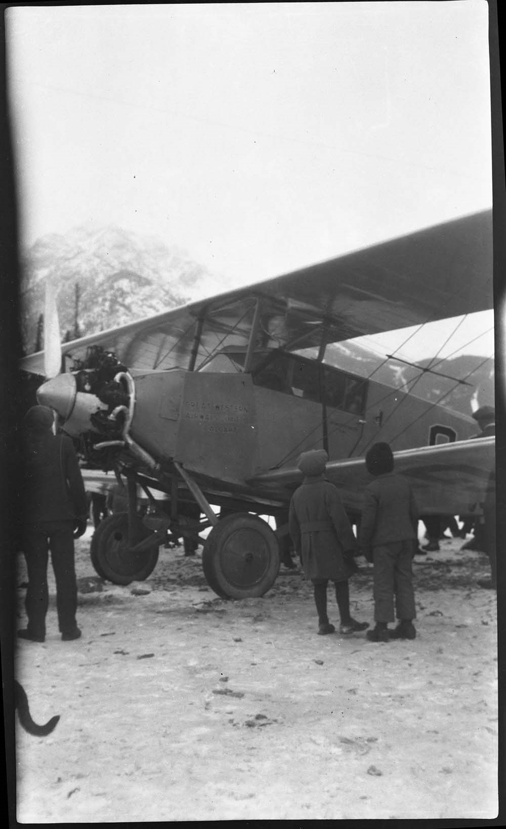
[Airplane on Bow River]
https://archives.whyte.org/en/permalink/descriptions23805
- Part Of
- Luxton family fonds
- Scope & Content
- Item consists of a b&w photograph negative of an airplane on the Bow River.
- Date Range
- 1929
- Reference Code
- LUX / I / D6c / NA - 65
- Description Level
- 6 / Item
- GMD
- Photograph
- Negative
1 image
- Part Of
- Luxton family fonds
- Description Level
- 6 / Item
- Fonds Number
- LUX
- Series
- LUX / I / D : Personal and professional
- Sous-Fonds
- LUX / I : Norman Luxton sous-fonds
- Sub-Series
- LUX / I / D / 6 : Other activities and interests
- Reference Code
- LUX / I / D6c / NA - 65
- GMD
- Photograph
- Negative
- Date Range
- 1929
- Physical Description
- 1photograph: b&w negative ; 15.2 x 9 cm
- Scope & Content
- Item consists of a b&w photograph negative of an airplane on the Bow River.
- Notes
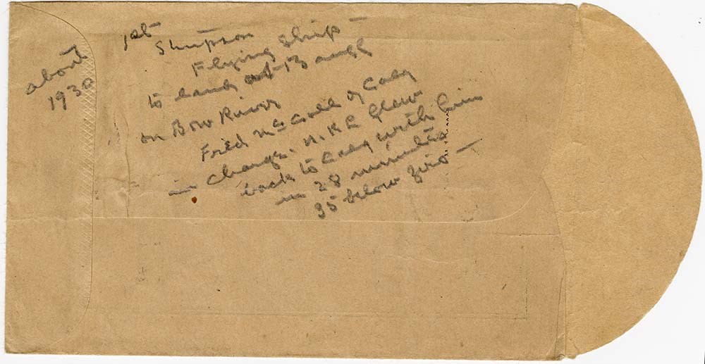
- Annotated envelope with LUX / I / D6c / NA - 66 indicates this is Fred McCall's landing of the Stinson Detrioter on the Bow River in January 1929
- Name Access
- Luxton, Norman
- McCall, Fred
- Geographic Access
- Banff
- Banff National Park
- Bow River
- Related Material
- LUX / I / D6c / NA - 66
- Title Source
- Title based on contents of file
- Processing Status
- Processed
Images
This material is presented as originally created; it may contain outdated cultural descriptions and
potentially offensive content.
Read more.
George Crawler (Yuzabi Toga), Stoney Nakoda
https://archives.whyte.org/en/permalink/descriptions29482
- Part Of
- Byron Harmon fonds
- Scope & Content
- George Crawler (Yuzabi Toga) at Banff Indian Days Stoney First Nation
- Date Range
- 1929
- Reference Code
- V263 / NA - 3267
- Description Level
- 6 / Item
- GMD
- Photograph
- Negative
1 image
- Part Of
- Byron Harmon fonds
- Description Level
- 6 / Item
- Fonds Number
- V263
- Series
- I. Scenic / commercial series
- Sous-Fonds
- V263
- Sub-Series
- A.1.a. Negatives, Main series : 13 x 18 cm and smaller
- Accession Number
- 2770
- Reference Code
- V263 / NA - 3267
- GMD
- Photograph
- Negative
- Parallel Title
- 540. Indian chief
- Other Title Info
- Parallel title is original title
- Date Range
- 1929
- Physical Description
- 1 photograph : negative, 13 x 18 cm or smaller
- Scope & Content
- George Crawler (Yuzabi Toga) at Banff Indian Days
- Stoney First Nation
- Name Access
- Crawler, George
- Subject Access
- Indigenous Peoples
- Stoney Nakoda
- First Nations
- Geographic Access
- Alberta
- Creator
- Byron Harmon (Banff, Alberta)
- Title Source
- Title based on contents of file
- Content Details
- Original identification made by Byron Harmon, his staff or Harmon family
- Processing Status
- Processed
Images

This material is presented as originally created; it may contain outdated cultural descriptions and
potentially offensive content.
Read more.
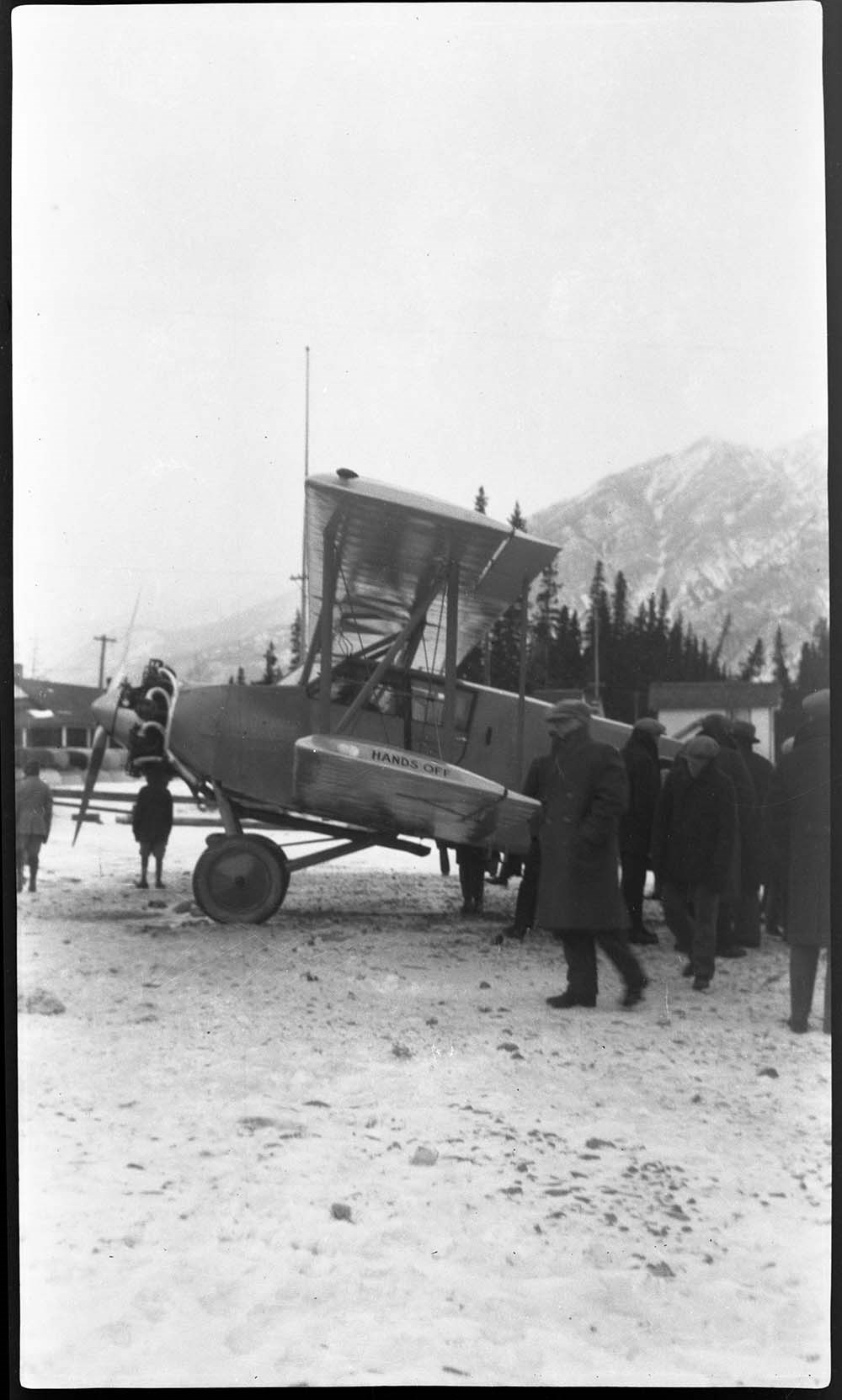
[Airplane on Bow River]
https://archives.whyte.org/en/permalink/descriptions57544
- Part Of
- Luxton family fonds
- Scope & Content
- Item consists of a b&w photograph negative of an airplane on the Bow River.
- Date Range
- 1929
- Reference Code
- LUX / I / D6c / NA - 66
- Description Level
- 6 / Item
- GMD
- Photograph
- Negative
3 images
- Part Of
- Luxton family fonds
- Description Level
- 6 / Item
- Fonds Number
- LUX
- Series
- LUX / I / D : Personal and professional
- Sous-Fonds
- LUX / I : Norman Luxton sous-fonds
- Sub-Series
- LUX / I / D / 6 : Other activities and interests
- Reference Code
- LUX / I / D6c / NA - 66
- GMD
- Photograph
- Negative
- Date Range
- 1929
- Physical Description
- 1photograph: b&w negative ; 15.2 x 9 cm
- Scope & Content
- Item consists of a b&w photograph negative of an airplane on the Bow River.
- Notes
- Annotated George Noble processing envelope indicates this is Fred McCall's landing of the Stinson Detrioter on the Bow River in January 1929
- Name Access
- Luxton, Norman
- McCall, Fred
- Geographic Access
- Banff
- Banff National Park
- Bow River
- Related Material
- LUX / I / D6c / NA - 66
- Title Source
- Title based on contents of file
- Processing Status
- Processed
Images
This material is presented as originally created; it may contain outdated cultural descriptions and
potentially offensive content.
Read more.
(Canmore area)
https://archives.whyte.org/en/permalink/catalogue24469
- Medium
- Library - Maps and blueprints (unannotated; published)
- Map
- Published Date
- October 22, 1928
- Publisher
- Dept. of the Interior
- Call Number
- C9-7.24
- Publisher
- Dept. of the Interior
- Published Date
- October 22, 1928
- Physical Description
- 1 map : black and white
- Scale
- 40 chains: 1 "
- Accession Number
- SG7500
- Call Number
- C9-7.24
- Collection
- Archives Library
This material is presented as originally created; it may contain outdated cultural descriptions and
potentially offensive content.
Read more.
[Northern Peace River Sheet] Pre-emptor's map
https://archives.whyte.org/en/permalink/catalogue24525
- Medium
- Library - Maps and blueprints (unannotated; published)
- Map
- Published Date
- 1928
- Publisher
- Department of Lands, B.C.
- Call Number
- C10-3.3
- Publisher
- Department of Lands, B.C.
- Published Date
- 1928
- Scale
- Scale: 4 miles: 1 inch
- Subjects
- British Columbia
- Northern Peace River
- Accession Number
- 495
- Call Number
- C10-3.3
- Collection
- Archives Library
This material is presented as originally created; it may contain outdated cultural descriptions and
potentially offensive content.
Read more.
- Medium
- Library - Maps and blueprints (unannotated; published)
- Map
- Published Date
- 1928
- Publisher
- Source: Canadian Geographica Survey
- Call Number
- C3-4.2
- Publisher
- Source: Canadian Geographica Survey
- Published Date
- 1928
- Scale
- Scale: 2 miles to 1 inch
- Relief: Contour interval 200'
- Subjects
- Windermere
- Accession Number
- 400
- Call Number
- C3-4.2
- Collection
- Archives Library
This material is presented as originally created; it may contain outdated cultural descriptions and
potentially offensive content.
Read more.
Boston in picture and story
https://archives.whyte.org/en/permalink/catalogue21516
- Medium
- Library - Maps and blueprints (unannotated; published)
- Map
- Published Date
- 1928
- Call Number
- C13-1.14
- Published Date
- 1928
- Subjects
- Boston, United States
- Notes
- 300 years of progress
- Accession Number
- 400
- Call Number
- C13-1.14
- Collection
- Archives Library
This material is presented as originally created; it may contain outdated cultural descriptions and
potentially offensive content.
Read more.
Kootenay Park
https://archives.whyte.org/en/permalink/catalogue23208
- Medium
- Library - Maps and blueprints (unannotated; published)
- Map
- Published Date
- 1928
- Publisher
- Ottawa: Office of the Surveyor General
- Call Number
- C2-5.3a
- Publisher
- Ottawa: Office of the Surveyor General
- Published Date
- 1928
- Physical Description
- 1 map : col
- Scale
- Scale: 1:126,720
- Subjects
- Kootenay National Park
- Accession Number
- 3206
- Call Number
- C2-5.3a
- Collection
- Archives Library
This material is presented as originally created; it may contain outdated cultural descriptions and
potentially offensive content.
Read more.
[Waterton Lakes Park]
https://archives.whyte.org/en/permalink/catalogue23215
- Medium
- Library - Maps and blueprints (unannotated; published)
- Map
- Published Date
- 1928
- Publisher
- Dept. of Mines and Technical Surveys
- Call Number
- C2-6.4(a)
- Publisher
- Dept. of Mines and Technical Surveys
- Published Date
- 1928
- Physical Description
- 1 map : col
- Scale
- Scale: 1 mile to 1 inch
- Subjects
- Waterton Lakes National Park
- Accession Number
- 2781
- Call Number
- C2-6.4(a)
- Collection
- Archives Library
This material is presented as originally created; it may contain outdated cultural descriptions and
potentially offensive content.
Read more.
Waterton Lakes Park
https://archives.whyte.org/en/permalink/catalogue23216
- Medium
- Library - Maps and blueprints (unannotated; published)
- Map
- Published Date
- 1928
- Publisher
- Ottawa : Topographical Survey of Canada
- Call Number
- C2-6.4b
- Publisher
- Ottawa : Topographical Survey of Canada
- Published Date
- 1928
- Physical Description
- 1 map : col
- Scale
- Scale: 1:63,360
- Subjects
- Waterton Lakes National Park
- Accession Number
- 3206
- Call Number
- C2-6.4b
- Collection
- Archives Library
This material is presented as originally created; it may contain outdated cultural descriptions and
potentially offensive content.
Read more.
[Silver fox furs]
https://archives.whyte.org/en/permalink/descriptions23840
- Part Of
- Luxton family fonds
- Scope & Content
- File consists of negatives of silver fox furs ; Mr. Lou Luxton, April 25, 1928.
- Date Range
- 1928
- Reference Code
- LUX / I / E4 / NA - 78 to NA - 79
- Description Level
- 5 / File
- GMD
- Photograph
- Negative
2 images
- Part Of
- Luxton family fonds
- Description Level
- 5 / File
- Fonds Number
- LUX
- Series
- LUX / I / E : Collected Material
- Sous-Fonds
- LUX / I : Norman Luxton sous-fonds
- Sub-Series
- LUX / I / E / 4 : Photographs
- Reference Code
- LUX / I / E4 / NA - 78 to NA - 79
- GMD
- Photograph
- Negative
- Date Range
- 1928
- Physical Description
- 2 photographs: b&w negatives ; 15 x 12 cm
- Scope & Content
- File consists of negatives of silver fox furs ; Mr. Lou Luxton, April 25, 1928.
- Subject Access
- Hunting
- Commercial products
- Geographic Access
- Banff
- Banff National Park
- Alberta
- Related Material
- See corresponding prints LUX / I / E4 PA-431.
- Processing Status
- Processed
Images


This material is presented as originally created; it may contain outdated cultural descriptions and
potentially offensive content.
Read more.
Geographic Board of Canada Map
https://archives.whyte.org/en/permalink/catalogue24354
- Medium
- Library - Maps and blueprints (unannotated; published)
- Map
- Published Date
- 1927
- Publisher
- Geographic Board of Canada
- Call Number
- C6-7.5(a)
- Publisher
- Geographic Board of Canada
- Published Date
- 1927
- Scale
- 35 miles to 1 inch
- Subjects
- Alberta
- Notes
- Illustrating "Place Names of Alberta"
- Accession Number
- 576
- Call Number
- C6-7.5(a)
- Collection
- Archives Library
This material is presented as originally created; it may contain outdated cultural descriptions and
potentially offensive content.
Read more.
- Medium
- Library - Maps and blueprints (unannotated; published)
- Map
- Published Date
- 1927
- Publisher
- Dept. of the Interior, Ottawa
- Call Number
- C9-1.2
- Publisher
- Dept. of the Interior, Ottawa
- Published Date
- 1927
- Physical Description
- 1 map: col
- Scale
- Scale: 12 1/2 miles: 1 inch
- Subjects
- Alberta
- Accession Number
- 400
- Call Number
- C9-1.2
- Collection
- Archives Library
This material is presented as originally created; it may contain outdated cultural descriptions and
potentially offensive content.
Read more.
Canadian Pacific Railway and connecting lines
https://archives.whyte.org/en/permalink/catalogue24565
- Medium
- Library - Maps and blueprints (unannotated; published)
- Map
- Published Date
- 1927
- Publisher
- [Montreal] : C.P.R.
- Call Number
- C11-3.17
- Publisher
- [Montreal] : C.P.R.
- Published Date
- 1927
- Physical Description
- 1 map : col
- Scale
- 1 inch = 110 miles
- Subjects
- Canadian Pacific Railway
- Accession Number
- 6596
- Call Number
- C11-3.17
- Collection
- Archives Library
This material is presented as originally created; it may contain outdated cultural descriptions and
potentially offensive content.
Read more.