Narrow Results By
- Byron Harmon fonds 3347
- George Noble fonds 2353
- Luxton family fonds 122
- Alpine Club of Canada fonds 21
- Tom Wilson family fonds 21
- Peter and Catharine Whyte fonds 18
- Bert Riggall fonds 10
- Arthur A. Goodsell fonds 7
- George Paris fonds 7
- Associated Screen News fonds 5
- Bruno Engler fonds 5
- James Irving McLeod fonds 5
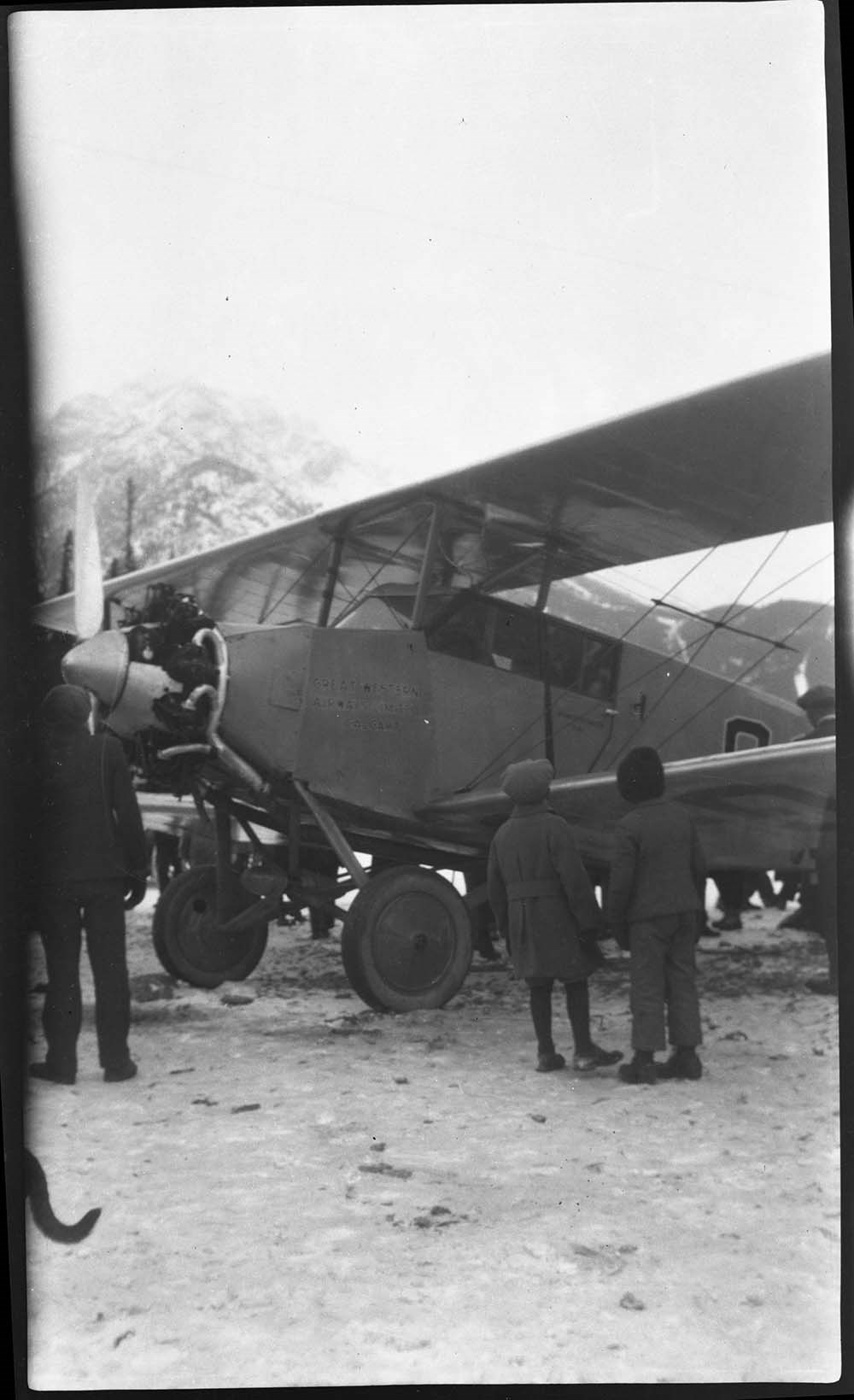
[Airplane on Bow River]
https://archives.whyte.org/en/permalink/descriptions23805
- Part Of
- Luxton family fonds
- Scope & Content
- Item consists of a b&w photograph negative of an airplane on the Bow River.
- Date Range
- 1929
- Reference Code
- LUX / I / D6c / NA - 65
- Description Level
- 6 / Item
- GMD
- Photograph
- Negative
1 image
- Part Of
- Luxton family fonds
- Description Level
- 6 / Item
- Fonds Number
- LUX
- Series
- LUX / I / D : Personal and professional
- Sous-Fonds
- LUX / I : Norman Luxton sous-fonds
- Sub-Series
- LUX / I / D / 6 : Other activities and interests
- Reference Code
- LUX / I / D6c / NA - 65
- GMD
- Photograph
- Negative
- Date Range
- 1929
- Physical Description
- 1photograph: b&w negative ; 15.2 x 9 cm
- Scope & Content
- Item consists of a b&w photograph negative of an airplane on the Bow River.
- Notes
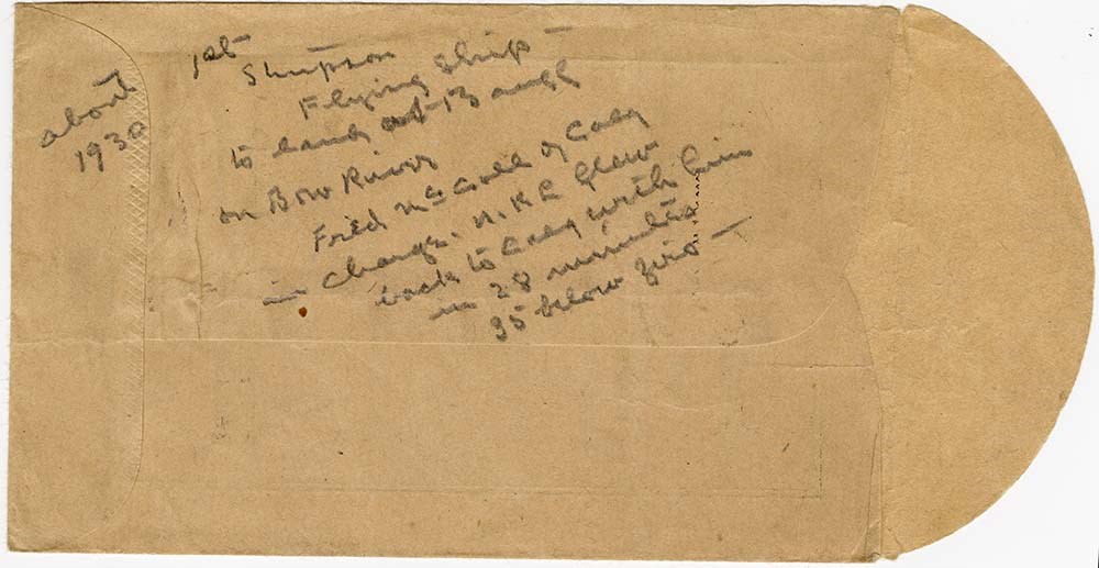
- Annotated envelope with LUX / I / D6c / NA - 66 indicates this is Fred McCall's landing of the Stinson Detrioter on the Bow River in January 1929
- Name Access
- Luxton, Norman
- McCall, Fred
- Geographic Access
- Banff
- Banff National Park
- Bow River
- Related Material
- LUX / I / D6c / NA - 66
- Title Source
- Title based on contents of file
- Processing Status
- Processed
Images
This material is presented as originally created; it may contain outdated cultural descriptions and
potentially offensive content.
Read more.
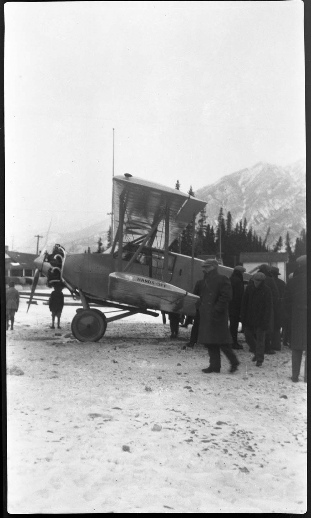
[Airplane on Bow River]
https://archives.whyte.org/en/permalink/descriptions57544
- Part Of
- Luxton family fonds
- Scope & Content
- Item consists of a b&w photograph negative of an airplane on the Bow River.
- Date Range
- 1929
- Reference Code
- LUX / I / D6c / NA - 66
- Description Level
- 6 / Item
- GMD
- Photograph
- Negative
3 images
- Part Of
- Luxton family fonds
- Description Level
- 6 / Item
- Fonds Number
- LUX
- Series
- LUX / I / D : Personal and professional
- Sous-Fonds
- LUX / I : Norman Luxton sous-fonds
- Sub-Series
- LUX / I / D / 6 : Other activities and interests
- Reference Code
- LUX / I / D6c / NA - 66
- GMD
- Photograph
- Negative
- Date Range
- 1929
- Physical Description
- 1photograph: b&w negative ; 15.2 x 9 cm
- Scope & Content
- Item consists of a b&w photograph negative of an airplane on the Bow River.
- Notes
- Annotated George Noble processing envelope indicates this is Fred McCall's landing of the Stinson Detrioter on the Bow River in January 1929
- Name Access
- Luxton, Norman
- McCall, Fred
- Geographic Access
- Banff
- Banff National Park
- Bow River
- Related Material
- LUX / I / D6c / NA - 66
- Title Source
- Title based on contents of file
- Processing Status
- Processed
Images
This material is presented as originally created; it may contain outdated cultural descriptions and
potentially offensive content.
Read more.
[Europe and the Near East]
https://archives.whyte.org/en/permalink/catalogue24854
- Medium
- Library - Maps and blueprints (unannotated; published)
- Map
- Published Date
- 1929
- Publisher
- National Geographic Society
- Call Number
- C13-12.1
- Publisher
- National Geographic Society
- Published Date
- 1929
- Scale
- 94.7 miles to 1 inch
- Subjects
- Europe and the Near East
- Accession Number
- 400
- Call Number
- C13-12.1
- Collection
- Archives Library
This material is presented as originally created; it may contain outdated cultural descriptions and
potentially offensive content.
Read more.
George Crawler (Yuzabi Toga), Stoney Nakoda
https://archives.whyte.org/en/permalink/descriptions29482
- Part Of
- Byron Harmon fonds
- Scope & Content
- George Crawler (Yuzabi Toga) at Banff Indian Days Stoney First Nation
- Date Range
- 1929
- Reference Code
- V263 / NA - 3267
- Description Level
- 6 / Item
- GMD
- Photograph
- Negative
1 image
- Part Of
- Byron Harmon fonds
- Description Level
- 6 / Item
- Fonds Number
- V263
- Series
- I. Scenic / commercial series
- Sous-Fonds
- V263
- Sub-Series
- A.1.a. Negatives, Main series : 13 x 18 cm and smaller
- Accession Number
- 2770
- Reference Code
- V263 / NA - 3267
- GMD
- Photograph
- Negative
- Parallel Title
- 540. Indian chief
- Other Title Info
- Parallel title is original title
- Date Range
- 1929
- Physical Description
- 1 photograph : negative, 13 x 18 cm or smaller
- Scope & Content
- George Crawler (Yuzabi Toga) at Banff Indian Days
- Stoney First Nation
- Name Access
- Crawler, George
- Subject Access
- Indigenous Peoples
- Stoney Nakoda
- First Nations
- Geographic Access
- Alberta
- Creator
- Byron Harmon (Banff, Alberta)
- Title Source
- Title based on contents of file
- Content Details
- Original identification made by Byron Harmon, his staff or Harmon family
- Processing Status
- Processed
Images

This material is presented as originally created; it may contain outdated cultural descriptions and
potentially offensive content.
Read more.
Banff National Park, Yoho Park and Kootenay Park
https://archives.whyte.org/en/permalink/catalogue21447
- Medium
- Library - Maps and blueprints (unannotated; published)
- Map
- Published Date
- 1929
- Publisher
- Canadian Pacific Railway
- Call Number
- C3-6.3(a)
- Publisher
- Canadian Pacific Railway
- Published Date
- 1929
- Physical Description
- Colour
- Subjects
- Canadian Rockies
- Notes
- Panoramic map showing main and branch lines of C.P.R.
- 3 duplicates in Map Room
- Accession Number
- 131
- 110
- 1120
- 3072
- Call Number
- C3-6.3(a)
- Collection
- Archives Library
This material is presented as originally created; it may contain outdated cultural descriptions and
potentially offensive content.
Read more.
[Rocky Mountains and Jasper Parks] Showing areas which it is proposed to withdraw from
https://archives.whyte.org/en/permalink/catalogue23194
- Medium
- Library - Maps and blueprints (unannotated; published)
- Map
- Published Date
- 1929
- Publisher
- Dept. of the Interior
- Call Number
- C2-3.8
- Publisher
- Dept. of the Interior
- Published Date
- 1929
- Physical Description
- 1 map : col
- Scale
- Scale: 1:792,000
- Subjects
- Rocky Mountains and Jasper Parks
- Accession Number
- 1230
- Call Number
- C2-3.8
- Collection
- Archives Library
This material is presented as originally created; it may contain outdated cultural descriptions and
potentially offensive content.
Read more.
[Northwest Territories]
https://archives.whyte.org/en/permalink/catalogue24375
- Medium
- Library - Maps and blueprints (unannotated; published)
- Map
- Published Date
- 1929
- Publisher
- Dept. of the Interior
- Call Number
- C8-3.1
- Publisher
- Dept. of the Interior
- Published Date
- 1929
- Physical Description
- 1 map : col
- Scale
- Scale: 60 miles to 1 inch
- Subjects
- Northwest Territories
- Notes
- R.C.M.P. posts, Radio Stations, Trading Posts, Boundaries and Names of Preserves
- Call Number
- C8-3.1
- Collection
- Archives Library
This material is presented as originally created; it may contain outdated cultural descriptions and
potentially offensive content.
Read more.
[Chipewyan, Alberta] Topographical Survey
https://archives.whyte.org/en/permalink/catalogue24413
- Medium
- Library - Maps and blueprints (unannotated; published)
- Map
- Published Date
- 1929
- Publisher
- Dept. of the Interior
- Call Number
- C9-2.1
- Publisher
- Dept. of the Interior
- Published Date
- 1929
- Physical Description
- 1 map : col
- Scale
- Scale: 4 miles: 1 inch
- Relief: Spot heights
- Subjects
- Chipewyan, Alberta
- Accession Number
- 400
- Call Number
- C9-2.1
- Collection
- Archives Library
This material is presented as originally created; it may contain outdated cultural descriptions and
potentially offensive content.
Read more.
[Stikine River, Northern B.C.]
https://archives.whyte.org/en/permalink/catalogue24528
- Medium
- Library - Maps and blueprints (unannotated; published)
- Map
- Published Date
- 1929
- Publisher
- Department of Lands, B.C.
- Call Number
- C10-3.6
- Publisher
- Department of Lands, B.C.
- Published Date
- 1929
- Scale
- Scale: 5 miles: 1 inch
- Relief: contour interval 500 ft.
- Subjects
- Northern British Columbia
- Stikine River
- Accession Number
- 495
- Call Number
- C10-3.6
- Collection
- Archives Library
This material is presented as originally created; it may contain outdated cultural descriptions and
potentially offensive content.
Read more.
(Canmore area)
https://archives.whyte.org/en/permalink/catalogue24469
- Medium
- Library - Maps and blueprints (unannotated; published)
- Map
- Published Date
- October 22, 1928
- Publisher
- Dept. of the Interior
- Call Number
- C9-7.24
- Publisher
- Dept. of the Interior
- Published Date
- October 22, 1928
- Physical Description
- 1 map : black and white
- Scale
- 40 chains: 1 "
- Accession Number
- SG7500
- Call Number
- C9-7.24
- Collection
- Archives Library
This material is presented as originally created; it may contain outdated cultural descriptions and
potentially offensive content.
Read more.
[Silver fox furs]
https://archives.whyte.org/en/permalink/descriptions23840
- Part Of
- Luxton family fonds
- Scope & Content
- File consists of negatives of silver fox furs ; Mr. Lou Luxton, April 25, 1928.
- Date Range
- 1928
- Reference Code
- LUX / I / E4 / NA - 78 to NA - 79
- Description Level
- 5 / File
- GMD
- Photograph
- Negative
2 images
- Part Of
- Luxton family fonds
- Description Level
- 5 / File
- Fonds Number
- LUX
- Series
- LUX / I / E : Collected Material
- Sous-Fonds
- LUX / I : Norman Luxton sous-fonds
- Sub-Series
- LUX / I / E / 4 : Photographs
- Reference Code
- LUX / I / E4 / NA - 78 to NA - 79
- GMD
- Photograph
- Negative
- Date Range
- 1928
- Physical Description
- 2 photographs: b&w negatives ; 15 x 12 cm
- Scope & Content
- File consists of negatives of silver fox furs ; Mr. Lou Luxton, April 25, 1928.
- Subject Access
- Hunting
- Commercial products
- Geographic Access
- Banff
- Banff National Park
- Alberta
- Related Material
- See corresponding prints LUX / I / E4 PA-431.
- Processing Status
- Processed
Images


This material is presented as originally created; it may contain outdated cultural descriptions and
potentially offensive content.
Read more.
Boston in picture and story
https://archives.whyte.org/en/permalink/catalogue21516
- Medium
- Library - Maps and blueprints (unannotated; published)
- Map
- Published Date
- 1928
- Call Number
- C13-1.14
- Published Date
- 1928
- Subjects
- Boston, United States
- Notes
- 300 years of progress
- Accession Number
- 400
- Call Number
- C13-1.14
- Collection
- Archives Library
This material is presented as originally created; it may contain outdated cultural descriptions and
potentially offensive content.
Read more.
Kootenay Park
https://archives.whyte.org/en/permalink/catalogue23208
- Medium
- Library - Maps and blueprints (unannotated; published)
- Map
- Published Date
- 1928
- Publisher
- Ottawa: Office of the Surveyor General
- Call Number
- C2-5.3a
- Publisher
- Ottawa: Office of the Surveyor General
- Published Date
- 1928
- Physical Description
- 1 map : col
- Scale
- Scale: 1:126,720
- Subjects
- Kootenay National Park
- Accession Number
- 3206
- Call Number
- C2-5.3a
- Collection
- Archives Library
This material is presented as originally created; it may contain outdated cultural descriptions and
potentially offensive content.
Read more.
[Waterton Lakes Park]
https://archives.whyte.org/en/permalink/catalogue23215
- Medium
- Library - Maps and blueprints (unannotated; published)
- Map
- Published Date
- 1928
- Publisher
- Dept. of Mines and Technical Surveys
- Call Number
- C2-6.4(a)
- Publisher
- Dept. of Mines and Technical Surveys
- Published Date
- 1928
- Physical Description
- 1 map : col
- Scale
- Scale: 1 mile to 1 inch
- Subjects
- Waterton Lakes National Park
- Accession Number
- 2781
- Call Number
- C2-6.4(a)
- Collection
- Archives Library
This material is presented as originally created; it may contain outdated cultural descriptions and
potentially offensive content.
Read more.
Waterton Lakes Park
https://archives.whyte.org/en/permalink/catalogue23216
- Medium
- Library - Maps and blueprints (unannotated; published)
- Map
- Published Date
- 1928
- Publisher
- Ottawa : Topographical Survey of Canada
- Call Number
- C2-6.4b
- Publisher
- Ottawa : Topographical Survey of Canada
- Published Date
- 1928
- Physical Description
- 1 map : col
- Scale
- Scale: 1:63,360
- Subjects
- Waterton Lakes National Park
- Accession Number
- 3206
- Call Number
- C2-6.4b
- Collection
- Archives Library
This material is presented as originally created; it may contain outdated cultural descriptions and
potentially offensive content.
Read more.
[Northern Peace River Sheet] Pre-emptor's map
https://archives.whyte.org/en/permalink/catalogue24525
- Medium
- Library - Maps and blueprints (unannotated; published)
- Map
- Published Date
- 1928
- Publisher
- Department of Lands, B.C.
- Call Number
- C10-3.3
- Publisher
- Department of Lands, B.C.
- Published Date
- 1928
- Scale
- Scale: 4 miles: 1 inch
- Subjects
- British Columbia
- Northern Peace River
- Accession Number
- 495
- Call Number
- C10-3.3
- Collection
- Archives Library
This material is presented as originally created; it may contain outdated cultural descriptions and
potentially offensive content.
Read more.
- Medium
- Library - Maps and blueprints (unannotated; published)
- Map
- Published Date
- 1928
- Publisher
- Source: Canadian Geographica Survey
- Call Number
- C3-4.2
- Publisher
- Source: Canadian Geographica Survey
- Published Date
- 1928
- Scale
- Scale: 2 miles to 1 inch
- Relief: Contour interval 200'
- Subjects
- Windermere
- Accession Number
- 400
- Call Number
- C3-4.2
- Collection
- Archives Library
This material is presented as originally created; it may contain outdated cultural descriptions and
potentially offensive content.
Read more.
Calgary Stampede rodeo postcards
https://archives.whyte.org/en/permalink/descriptions55012
- Part Of
- Luxton family fonds
- Scope & Content
- File consists of 6 postcard prints pertaining to events at the Calgary Stampede in 1927. Includes images of participants riding horses and cattle during calf roping and other rodeo events. Named individuals in photographs are : Ted McCroey, Chester Byers, Walter Heacock, Emil Small Face, Cheyenne K…
- Date Range
- 1927
- Reference Code
- LUX / I / D3c / PG - 1 to 6
- Description Level
- 5 / File
- GMD
- Postcard
- Part Of
- Luxton family fonds
- Description Level
- 5 / File
- Fonds Number
- LUX
- Series
- LUX / I / D : Personal and Professional
- Sous-Fonds
- LUX / I : Norman Luxton sous-fonds
- Sub-Series
- LUX / I / D3 : Organizations
- Accession Number
- LUX
- Reference Code
- LUX / I / D3c / PG - 1 to 6
- Date Range
- 1927
- Physical Description
- 6 prints : b&w postcards ; 14 x 8.5 cm
- Scope & Content
- File consists of 6 postcard prints pertaining to events at the Calgary Stampede in 1927. Includes images of participants riding horses and cattle during calf roping and other rodeo events. Named individuals in photographs are : Ted McCroey, Chester Byers, Walter Heacock, Emil Small Face, Cheyenne Kaiser, and T. Parchuk.
- Material Details
- Items each annotated on front side in white lettering at bottom of image; back sides are blank
- Subject Access
- Events
- Public events
- Calgary Stampede
- Animals
- Horses
- Competition
- Sports and recreation
- Geographic Access
- Canada
- Alberta
- Calgary
- Language
- English
- Conservation
- Original paper envelope which held postcards may need to be removed from file or placed in mylar due to contact with photographic material
- Category
- Sports, recreation and leisure
- Title Source
- Title based on contents of file
- Processing Status
- Processed
This material is presented as originally created; it may contain outdated cultural descriptions and
potentially offensive content.
Read more.
Map of the mountains from Calgary to Sicamous
https://archives.whyte.org/en/permalink/catalogue21446
- Medium
- Library - Maps and blueprints (unannotated; published)
- Map
- Published Date
- 1927
- Publisher
- Canadian Pacific Railway
- Call Number
- C3-6.2
- Publisher
- Canadian Pacific Railway
- Published Date
- 1927
- Physical Description
- Colour
- Subjects
- Canadian Pacific Rockies
- Notes
- Panoramic map
- Accession Number
- 74
- 3069
- 2933
- Call Number
- C3-6.2
- Collection
- Archives Library
This material is presented as originally created; it may contain outdated cultural descriptions and
potentially offensive content.
Read more.
- Medium
- Library - Maps and blueprints (unannotated; published)
- Map
- Published Date
- 1927
- Publisher
- Ottawa: Topographical Survey of Canada
- Call Number
- C2-4.3a
- Publisher
- Ottawa: Topographical Survey of Canada
- Published Date
- 1927
- Physical Description
- 1 map : col
- Scale
- Scale: 1:126,270
- Subjects
- Yoho National Park
- Accession Number
- 4008 deaccessioned
- 3069
- 5956 deaccessioned
- Call Number
- C2-4.3a
- Collection
- Archives Library
This material is presented as originally created; it may contain outdated cultural descriptions and
potentially offensive content.
Read more.