Narrow Results By
- Luxton family fonds 79
- George McLean fonds 36
- Nicholas Morant fonds 36
- Kidney family fonds 25
- Eliza Hunter fonds 14
- Archives General File Collection 11
- Trail Riders of the Canadian Rockies fonds 9
- Dorothy Cranstone fonds 8
- Dorothy Wardle fonds 8
- Lawrence Grassi fonds 8
- Jean Knox Petrie fonds 6
- Alpine Club of Canada fonds 5
[Hightower Creek - Alberta]
https://archives.whyte.org/en/permalink/catalogue23660
- Medium
- Library - Maps and blueprints (unannotated; published)
- Map
- Published Date
- 1949
- Publisher
- Dept. of Mines & Technical Surv.
- Call Number
- NTS
- 83F/13E
- Publisher
- Dept. of Mines & Technical Surv.
- Published Date
- 1949
- Scale
- 1:50,000
- Subjects
- Hightower Creek - Alberta
- Notes
- National Topographic System
- Accession Number
- 12000
- Call Number
- NTS
- 83F/13E
- Collection
- Archives Library
This material is presented as originally created; it may contain outdated cultural descriptions and
potentially offensive content.
Read more.
[Hightower Creek - Alberta]
https://archives.whyte.org/en/permalink/catalogue23661
- Medium
- Library - Maps and blueprints (unannotated; published)
- Map
- Published Date
- 1949
- Publisher
- Dept. of Mines & Technical Survey
- Call Number
- NTS
- 83F/13W
- Publisher
- Dept. of Mines & Technical Survey
- Published Date
- 1949
- Scale
- 1:50,000
- Subjects
- Hightower Creek - Alberta
- Notes
- National Topographic System
- Accession Number
- 12000
- Call Number
- NTS
- 83F/13W
- Collection
- Archives Library
This material is presented as originally created; it may contain outdated cultural descriptions and
potentially offensive content.
Read more.
Topographical Map
https://archives.whyte.org/en/permalink/catalogue24619
- Medium
- Library - Maps and blueprints (unannotated; published)
- Map
- Published Date
- 1948
- Publisher
- Dept. of Mines and Resources
- Call Number
- C3-2.4
- Publisher
- Dept. of Mines and Resources
- Published Date
- 1948
- Physical Description
- Colour
- Scale
- Scale: 1:63,360
- Relief: Contour interval 100'
- Subjects
- Lake Louise
- Accession Number
- 1105
- Call Number
- C3-2.4
- Collection
- Archives Library
This material is presented as originally created; it may contain outdated cultural descriptions and
potentially offensive content.
Read more.
Province of Alberta
https://archives.whyte.org/en/permalink/catalogue24409
- Medium
- Library - Maps and blueprints (unannotated; published)
- Map
- Published Date
- 1947
- Publisher
- Alberta Dept. of Lands and Mines
- Call Number
- C9-1.19
- Publisher
- Alberta Dept. of Lands and Mines
- Published Date
- 1947
- Physical Description
- 1 map
- Scale
- Scale: 1 inch = 16 miles
- Subjects
- Alberta
- Notes
- In oversize cabinet (rolled up)
- Accession Number
- 6406
- Call Number
- C9-1.19
- Collection
- Archives Library
This material is presented as originally created; it may contain outdated cultural descriptions and
potentially offensive content.
Read more.
Topographic Map
https://archives.whyte.org/en/permalink/catalogue24621
- Medium
- Library - Maps and blueprints (unannotated; published)
- Map
- Published Date
- 1947
- Publisher
- Dept. of Mines and Resources
- Call Number
- C3-3.1
- Publisher
- Dept. of Mines and Resources
- Published Date
- 1947
- Physical Description
- Colour
- Scale
- Scale: 1": 1 mile
- Relief: Contour interval 100'
- Subjects
- Sunwapta
- Accession Number
- 442
- Call Number
- C3-3.1
- Collection
- Archives Library
This material is presented as originally created; it may contain outdated cultural descriptions and
potentially offensive content.
Read more.
Jasper Park South Sheet
https://archives.whyte.org/en/permalink/catalogue23180
- Medium
- Library - Maps and blueprints (unannotated; published)
- Map
- Published Date
- 1947
- Publisher
- Dept. of Mines and Resources
- Call Number
- C2-2.7
- Publisher
- Dept. of Mines and Resources
- Published Date
- 1947
- Scale
- Scale: 3 miles to 1 inch
- Notes
- Relief: Contour Interval 200'
- Accession Number
- 400, 718
- Call Number
- C2-2.7
- Collection
- Archives Library
This material is presented as originally created; it may contain outdated cultural descriptions and
potentially offensive content.
Read more.
[Jasper Park]
https://archives.whyte.org/en/permalink/catalogue23181
- Medium
- Library - Maps and blueprints (unannotated; published)
- Map
- Published Date
- 1947
- Publisher
- Dept. of Mines and Technical Surveys
- Call Number
- C2-2.8
- Publisher
- Dept. of Mines and Technical Surveys
- Published Date
- 1947
- Physical Description
- 1 map : col
- Scale
- Scale: 1 inch : 3 miles
- Relief: Contour Interval 200 ft
- Subjects
- Jasper National Park
- Notes
- Dup. in Research Room/2 Dup. in Map Room
- Accession Number
- 3000
- 673
- 1153 M. 171
- 1096
- 3349
- Call Number
- C2-2.8
- Collection
- Archives Library
This material is presented as originally created; it may contain outdated cultural descriptions and
potentially offensive content.
Read more.
[Jasper Park (South Sheet)]
https://archives.whyte.org/en/permalink/catalogue23182
- Medium
- Library - Maps and blueprints (unannotated; published)
- Map
- Published Date
- 1947 (interim corrections 1974)
- Publisher
- Department of Mines and Technical Surveys
- Call Number
- C2-2.8 (a)
- Publisher
- Department of Mines and Technical Surveys
- Published Date
- 1947 (interim corrections 1974)
- Physical Description
- 1 map : col
- Scale
- Scale: I inch: 3 miles
- Relief: Counter interval 200 ft.
- Subjects
- Jasper National Park
- Accession Number
- 7000
- Call Number
- C2-2.8 (a)
- Collection
- Archives Library
This material is presented as originally created; it may contain outdated cultural descriptions and
potentially offensive content.
Read more.
[Deep Valley Creek South, Alberta]
https://archives.whyte.org/en/permalink/catalogue23579
- Medium
- Library - Maps and blueprints (unannotated; published)
- Map
- Published Date
- 1947
- Publisher
- Dept. of Mines & Technical Survey
- Call Number
- NTS
- 82K/4E
- Publisher
- Dept. of Mines & Technical Survey
- Published Date
- 1947
- Scale
- Scale: 1:50,000
- Subjects
- Deep Valley Creek
- Alberta
- Notes
- National Topographic System
- Accession Number
- 12000
- Call Number
- NTS
- 82K/4E
- Collection
- Archives Library
This material is presented as originally created; it may contain outdated cultural descriptions and
potentially offensive content.
Read more.
[Deep Valley Creek South, Alberta]
https://archives.whyte.org/en/permalink/catalogue23580
- Medium
- Library - Maps and blueprints (unannotated; published)
- Map
- Published Date
- 1947
- Publisher
- Dept. of Mines & Technical Survey
- Call Number
- NTS
- 83K/4W
- Publisher
- Dept. of Mines & Technical Survey
- Published Date
- 1947
- Scale
- Scale: 1:50,000
- Subjects
- Deep Valley Creek
- Alberta
- Notes
- National Topographic System
- Accession Number
- 12000
- Call Number
- NTS
- 83K/4W
- Collection
- Archives Library
This material is presented as originally created; it may contain outdated cultural descriptions and
potentially offensive content.
Read more.
[Moberly Creek - Alberta]
https://archives.whyte.org/en/permalink/catalogue23741
- Medium
- Library - Maps and blueprints (unannotated; published)
- Map
- Published Date
- 1946
- Publisher
- Dept. of Mines & Technical Surveys
- Call Number
- NTS
- 83E/9
- Publisher
- Dept. of Mines & Technical Surveys
- Published Date
- 1946
- Scale
- 1:50,000
- Subjects
- Moberly Creek - Alberta
- Notes
- National Topographic System
- Provisional Map
- Accession Number
- 12000
- Call Number
- NTS
- 83E/9
- Collection
- Archives Library
This material is presented as originally created; it may contain outdated cultural descriptions and
potentially offensive content.
Read more.
[United States]
https://archives.whyte.org/en/permalink/catalogue24812
- Medium
- Library - Maps and blueprints (unannotated; published)
- Map
- Published Date
- 1946
- Publisher
- National Geographic Society
- Call Number
- C13-1.1(d)
- Publisher
- National Geographic Society
- Published Date
- 1946
- Scale
- Scale: 78.91 miles to 1 inch
- Relief: Bench marks
- Subjects
- United States
- Accession Number
- 495
- Call Number
- C13-1.1(d)
- Collection
- Archives Library
This material is presented as originally created; it may contain outdated cultural descriptions and
potentially offensive content.
Read more.
[RECONNAISSANCE PLAN: BANFF_MT. ASSINIBOINE PARK ROUTE 4 via Healy Creek, Sunshine Lodge, Citadel Pass]
https://archives.whyte.org/en/permalink/catalogue24909
- Medium
- Library - Maps and blueprints (unannotated; published)
- Map
- Published Date
- 1946 (transfered to manuscript Oct. 1994)
- Call Number
- C2-10.1 (d)
- Published Date
- 1946 (transfered to manuscript Oct. 1994)
- Scale
- 1) Scale: 4 ": 1 mile
- Relief - Counter interval 50 ft.
- 2) Scale: 1 ": 200 ft.
- Relief - Counter interval: 5 ft.
- Subjects
- Mount Assiniboine Provincial Park
- Notes
- 2) = Plan of Healy Creek_Mt. Assiniboine Proposed Location Class "C" Highway Survey 1946/Section 1_Banff to Healy Creek
- 5) Sunshine to Quartz Hill
- 6) 3 sections
- Accession Number
- 2158
- Call Number
- C2-10.1 (d)
- Collection
- Archives Library
This material is presented as originally created; it may contain outdated cultural descriptions and
potentially offensive content.
Read more.
Map showing Coalfields, Potential Coal Areas and Coal occurences of Canada
https://archives.whyte.org/en/permalink/catalogue21472
- Medium
- Library - Book (including soft-cover and pamphlets)
- Map
- Published Date
- 1946
- Publisher
- Dept. of Mines and Resources
- Call Number
- C7-5.7
- Publisher
- Dept. of Mines and Resources
- Published Date
- 1946
- Subjects
- Canada - Coal Areas
- Accession Number
- 3071
- Call Number
- C7-5.7
- Collection
- Archives Library
This material is presented as originally created; it may contain outdated cultural descriptions and
potentially offensive content.
Read more.
Glacier Park, B.C.
https://archives.whyte.org/en/permalink/catalogue23225
- Medium
- Library - Maps and blueprints (unannotated; published)
- Map
- Published Date
- 1946
- Publisher
- Ottawa, Tophographical Survey of Canada
- Call Number
- C2-7.5a
- Publisher
- Ottawa, Tophographical Survey of Canada
- Published Date
- 1946
- Physical Description
- 1 map : col
- Scale
- Scale: 1:126,720
- Subjects
- Glacier National Park
- Accession Number
- 3349
- Call Number
- C2-7.5a
- Collection
- Archives Library
This material is presented as originally created; it may contain outdated cultural descriptions and
potentially offensive content.
Read more.
[Blairmore 82G/9 West, Alberta]
https://archives.whyte.org/en/permalink/catalogue23501
- Medium
- Library - Maps and blueprints (unannotated; published)
- Map
- Published Date
- 1946
- Publisher
- Dept. of Mines and Techinical Surveys
- Call Number
- NTS
- 82G/9W
- Publisher
- Dept. of Mines and Techinical Surveys
- Published Date
- 1946
- Physical Description
- 1 map : col
- Scale
- Scale: 1:50,000
- Relief: Contour interval 100'
- Subjects
- Blairmore
- Western Alberta
- Notes
- National Topographic System
- Call Number
- NTS
- 82G/9W
- Collection
- Archives Library
This material is presented as originally created; it may contain outdated cultural descriptions and
potentially offensive content.
Read more.
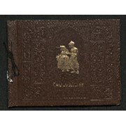
Trail ride album
https://archives.whyte.org/en/permalink/descriptions14151
- Scope & Content
- Photograph album contains 182 black and white prints pertaining to trail rides in July/August, 1945 through Baker Creek, Ptarmigan Lake, Skoki and Lake Louise; and Lake O'Hara, Lake McArthur and Odaray Trail. Images depict riders on horseback, scenic views of mountains, waterfalls, forests and land…
- Date Range
- 1945
- Reference Code
- V635 / I / PD - 3
- Description Level
- 5 / File
- GMD
- Album
- Photograph
- Photograph print
- Textual record
1 image
1 Electronic Resource
- Description Level
- 5 / File
- Fonds Number
- M545 / V635
- Series
- V635 / I : Events and Activities
- Sous-Fonds
- V635
- Accession Number
- 5757
- Reference Code
- V635 / I / PD - 3
- Responsibility
- Trail Riders of the Canadian Rockies
- Date Range
- 1945
- Physical Description
- 1 photograph album (182 prints)
- Scope & Content
- Photograph album contains 182 black and white prints pertaining to trail rides in July/August, 1945 through Baker Creek, Ptarmigan Lake, Skoki and Lake Louise; and Lake O'Hara, Lake McArthur and Odaray Trail. Images depict riders on horseback, scenic views of mountains, waterfalls, forests and landscapes, individual and group photographs of riders, and campsites. Most photographs not annotated and people in photographs not named. Album also contains three pamphlets pertaining to 1945 trail rides with lists of locations and attendees.
- Subject Access
- Travel
- Hiking
- Packing
- Horses
- Mountain
- Waterfall
- Landscapes
- Trail
- Lake
- Trail Riders of the Canadian Rockies
- Geographic Access
- Canada
- Alberta
- Canadian Rocky Mountains
- Language
- English
- Creator
- Unknown
- Title Source
- Title based on contents of file
- Processing Status
- Processed
Electronic Resources
Images

This material is presented as originally created; it may contain outdated cultural descriptions and
potentially offensive content.
Read more.
[Waterton Lakes Park]
https://archives.whyte.org/en/permalink/catalogue23214
- Medium
- Library - Maps and blueprints (unannotated; published)
- Map
- Published Date
- 1945
- Publisher
- Dept. of Mines and Resources
- Call Number
- C2-6.4
- Publisher
- Dept. of Mines and Resources
- Published Date
- 1945
- Physical Description
- 1 map : col
- Scale
- Scale: 1 inch : 1 mile
- Contour Interval 100 ft.
- Subjects
- Waterton Lakes National Park
- Notes
- 1 duplicate - Accn. 2781
- Accession Number
- 718
- 2781
- Call Number
- C2-6.4
- Collection
- Archives Library
This material is presented as originally created; it may contain outdated cultural descriptions and
potentially offensive content.
Read more.
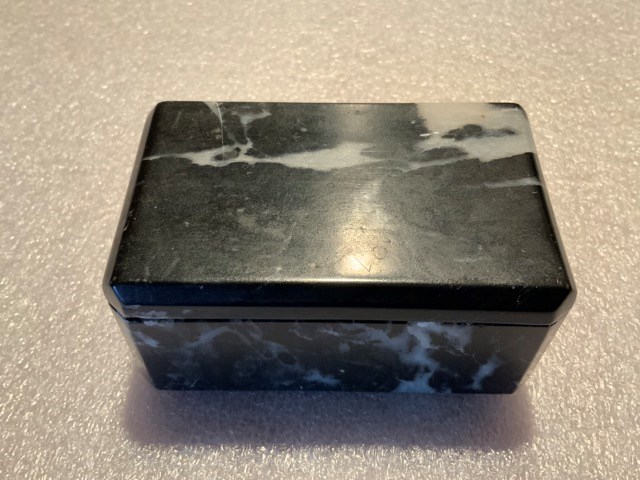
- Date
- 1945 – 1945
- Material
- stone
- Catalogue Number
- 102.04.0201
- Description
- A hand-carved, well-made, lidded box carved from soft Rocky Mountain marble. The box has a front and a back. The front has bevelled corners, whereas the back has square corners. The box interior has rounded corners and the lid fits smoothly and flushly into the cutout. Base is felted with green fel…
1 image
- Title
- Trinket Box
- Date
- 1945 – 1945
- Material
- stone
- Dimensions
- 4.3 x 5.7 x 9.2 cm
- Description
- A hand-carved, well-made, lidded box carved from soft Rocky Mountain marble. The box has a front and a back. The front has bevelled corners, whereas the back has square corners. The box interior has rounded corners and the lid fits smoothly and flushly into the cutout. Base is felted with green felt. The marble is black, streaked with white.
- Credit
- Gift of Catharine Robb Whyte, O. C., Banff, 1979
- Catalogue Number
- 102.04.0201
Images
This material is presented as originally created; it may contain outdated cultural descriptions and
potentially offensive content.
Read more.
[Mountain View 82 H/4 East - Alberta]
https://archives.whyte.org/en/permalink/catalogue23785
- Medium
- Library - Maps and blueprints (unannotated; published)
- Map
- Published Date
- 1944
- Publisher
- Dept. of Mines and Technical Surveys
- Call Number
- NTS
- 82H/4E
- Publisher
- Dept. of Mines and Technical Surveys
- Published Date
- 1944
- Physical Description
- Black and White
- Scale
- Scale: 1:50,000
- Relief: Contour interval 100'
- Subjects
- Mountain View 82 H/4 East - Alberta
- Notes
- National Topographic System
- Call Number
- NTS
- 82H/4E
- Collection
- Archives Library
This material is presented as originally created; it may contain outdated cultural descriptions and
potentially offensive content.
Read more.